

Mori Atlas logo
Marine protected areaMontebello Islands Marine Park

Mapping the remote reef systems and tropical island landscapes of Western Australia

Montebello Islands Marine Park: An Offshore Marine Protected Area and Archipelago Geography

(Montebello Island Marine Park)

The Montebello Islands Marine Park encompasses a scattered archipelago and extensive reef systems off the northwest coast of Western Australia. As a vital marine protected area, it features diverse underwater topography where shallow tropical lagoons meet the edge of the continental shelf. This geography supports critical sea turtle nesting grounds and complex coral ecosystems, situated within a broader regional network of protected marine habitats.

marine parktropical marine ecosystemcoral reefssea turtlesisland archipelagomangroves

Montebello Islands Marine Park

Marine protected area

Park overview

Structured park overview, official facts, and landscape profile for Montebello Islands Marine Park

Montebello Islands Marine Park park facts, protected area profile, and essential visitor context

Review the core facts for Montebello Islands Marine Park, including designation, size, terrain, visitor scale, habitats, and operating context in one park-focused overview.

About Montebello Islands Marine Park

The Montebello Islands Marine Park is a Western Australian offshore marine protected area that covers the entire Montebello Islands archipelago, a group of low-lying islands and islets scattered across the tropical waters off Australia's Pilbara coast. Although the islands themselves are small and largely uninhabited today, the surrounding marine environment is highly productive, supporting tropical reef systems, mangrove communities, and important populations of marine mammals, sea turtles, and pelagic species.

Geographically, the marine park sits on the edge of the continental shelf, where shallow coastal waters transition into deeper oceanic environments. This transition zone helps explain the area's biological richness, because nutrient exchange across the shelf edge supports both reef-building corals and the broader food webs that sustain sea turtles, whales, dolphins, and large predatory fish. The reef and seabed environments shelter hard corals, echinoderms such as sea stars and sea cucumbers, and a wide spectrum of molluscs, creating a foundation for the park's wider ecological identity.

Equally important to the park's character is its geographic and political context. The marine park lies within one of Australia's most significant hydrocarbon regions, directly adjacent to the Gorgon gas field, which is considered one of the country's largest natural gas resources. The coexistence of major industrial activity and strict marine protection gives the area a distinctive dual identity, making the Montebello Islands Marine Park both an ecological refuge and a node within a heavily used coastal-industrial zone.

The park is administered as an IUCN Category II area, reflecting a strong level of protection for its natural and scenic values, and it forms part of a larger marine conservation network alongside neighbouring Barrow Island reserves. Together these protections help safeguard breeding populations of marine turtles, populations of resident and migratory cetaceans, and the reef and mangrove habitats that anchor the broader marine ecosystem of the region.

Quick facts and research context for Montebello Islands Marine Park

The Montebello Islands Marine Park covers an area of about 58,331 hectares and was formally gazetted on 10 December 2004. It is administered by the Western Australian Department of Biodiversity, Conservation and Attractions and is classified as an IUCN Category II protected area, equivalent to a national park.

The park lies more than a hundred kilometres offshore from the Pilbara coast and is composed of the full Montebello Islands archipelago, surrounded by tropical waters that support coral reefs, mangrove-fringed lagoons, and a wide variety of marine life. Nearby reserves include the much larger Barrow Island Marine Management Area, which extends protection across an even broader marine landscape adjacent to the park.

Protection and recognition

Explore documented marine conservation scope and international recognition details

Montebello Islands Marine Park Protection Status and Designation Records

Montebello Islands Marine Park maintains a defined marine conservation scope within its regional protected area framework. Structured designation records outline the formal management parameters associated with this marine environment.

Protection details

Protection scope
Marine
Transboundary protection
No
Park context

Deeper park guide and search-rich context for Montebello Islands Marine Park

Montebello Islands Marine Park history, landscape, wildlife, and travel context

Explore Montebello Islands Marine Park through its history, landscape character, ecosystems, wildlife, conservation priorities, cultural context, and seasonal travel timing in a structured park guide built for atlas discovery and search intent.

Why Montebello Islands Marine Park stands out

The Montebello Islands Marine Park is best known for its role as a key breeding and nesting area for several species of sea turtles, including flatback, green, and hawksbill turtles, as well as occasional loggerhead turtles. The archipelago's beaches and lagoon systems provide important conditions for turtle reproduction in a region where such habitat is otherwise limited. The park is also known for the diversity of its marine ecosystems, with roughly 150 species of hard corals, more than 450 fish species, 170 echinoderm species, and over 630 mollusc species documented in surrounding waters. Six mangrove species colonize parts of the coastline and lagoon systems, adding a productive tropical estuarine element to the marine environment. Beyond its ecology, the area is recognized for its layered human history, including British-Australian nuclear testing during the 1950s and its proximity to the strategically important Gorgon gas project.
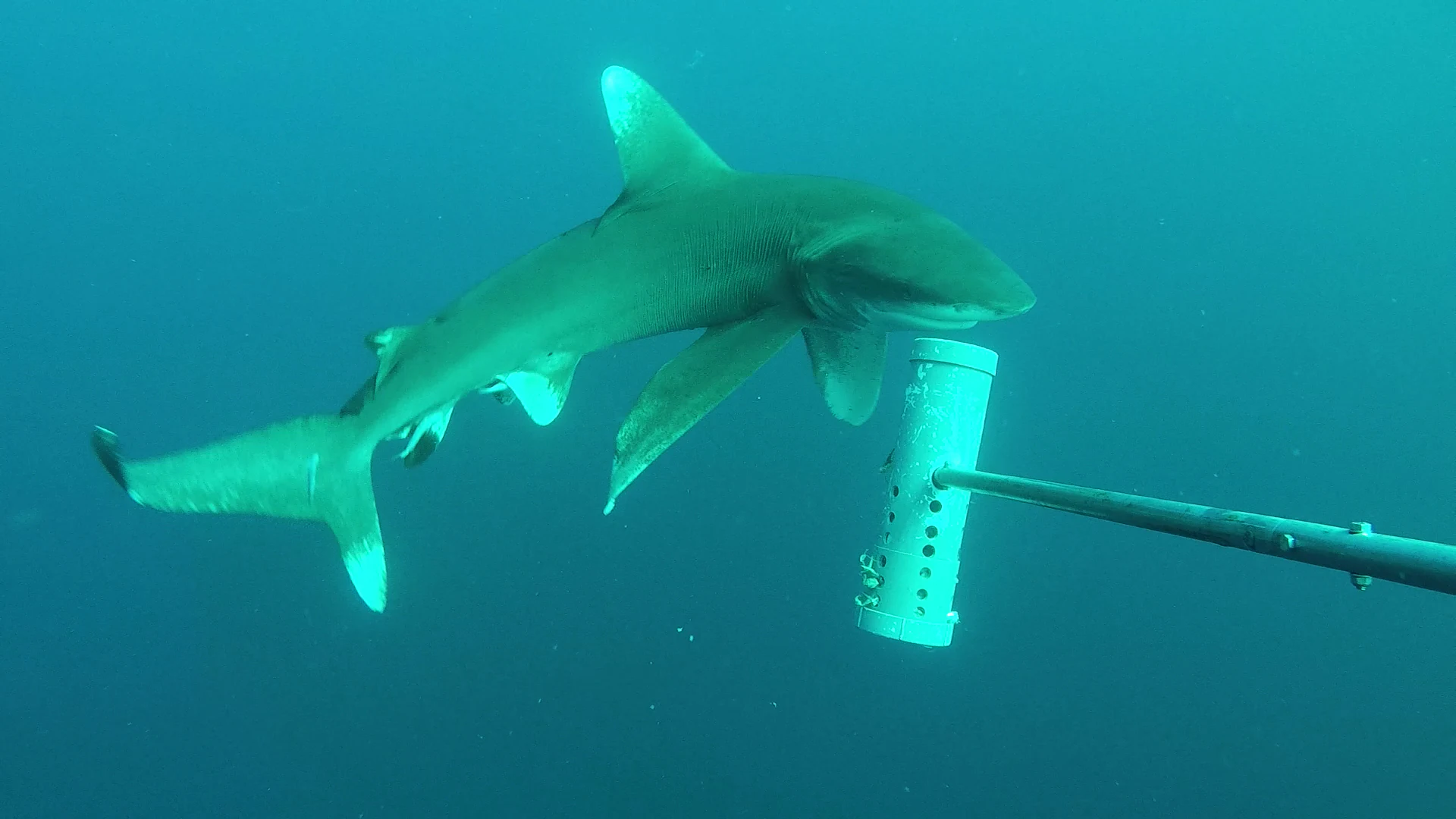
An oceanic whitetip shark swimming in clear blue water, approaching a white, cylindrical, perforated research bait canister mounted on a pole.
An oceanic whitetip shark investigated by a research tool in Montebello Islands Marine Park.

Montebello Islands Marine Park history and protected-area timeline

The Montebello Islands Marine Park was formally established on 10 December 2004, creating a formal protection regime over the entire Montebello Islands group and the surrounding waters. The designation came as part of a broader wave of marine conservation planning in Western Australia, with the park and its neighbouring Barrow Island reserves forming one of the largest contiguous marine protection complexes along the state's northwest coast.

The islands themselves, however, have a much longer and more complicated history. In 1952 and again in 1956, the British and Australian governments conducted atomic weapons tests on and near Alpha and Tremouille Islands in the Montebello group, leaving a legacy of nuclear testing activity that continues to influence how the islands are managed and studied. These tests shaped both the physical and cultural memory of the archipelago long before formal marine protection was established.

The region also carries a long history of marine resource use. Cultured pearl production has been carried out in the broader area since 1902, and commercial fishing for sharks and turtles has occurred in waters around the islands. Today those activities coexist with recreational fishing, diving, snorkelling, wildlife observation, and other nature-based tourism that forms part of the modern economic profile of the marine park and its surroundings.

Montebello Islands Marine Park landscape and geographic character

The Montebello Islands Marine Park is defined less by dramatic terrestrial scenery than by the marine seascape that surrounds it. The park consists of a scattered archipelago of low islands and islets sitting near the edge of the northwest Australian continental shelf, where warm tropical waters of the Indian Ocean meet deeper offshore environments. This shelf-edge setting gives the area a varied underwater topography composed of reef flats, submerged banks, and sloping seabeds that support hard corals and a wide range of associated marine life.

On the islands themselves, the physical environment remains relatively subdued, with low-relief landforms typical of the Pilbara offshore islands. Sandy beaches and sheltered lagoon systems form important shoreline features, while the coastline is fringed in places by mangrove communities that thrive in the protected shallow waters. These mangrove-lined coasts and lagoon environments provide sheltered habitat for juvenile fish, invertebrates, and the turtle populations for which the park is widely recognized.

Beyond the islands, the broader marine landscape continues into deeper waters where pelagic species move along productive oceanic routes. The combination of shallow reef and lagoon environments with deeper offshore waters gives the park a layered physical setting, in which reef-building corals, soft-bottom communities, and open-water ecosystems are all represented within a single protected area.

Montebello Islands Marine Park ecosystems, habitats, and plant life

The marine ecosystems of the Montebello Islands Marine Park reflect the broader tropical character of northwest Australian coastal waters, where reef, mangrove, and pelagic systems interact across the continental shelf. Hard coral communities form the structural backbone of much of the reef environment, with roughly 150 species of hard corals documented in the marine area. These corals support dense and varied reef fish communities, with more than 450 fish species recorded across the park.

Mangrove environments play an important ecological role along parts of the coastline and within lagoon systems. Six mangrove species are present, creating sheltered habitats that serve as nursery areas for marine life and stabilise shoreline sediments. These mangrove fringes, together with the reef systems, support an unusually diverse array of invertebrates, including 170 echinoderm species and more than 630 mollusc species that contribute to the overall biodiversity of the marine park.

The tropical setting also supports seasonal movements of large marine animals, including migratory cetaceans that travel through the offshore waters. The combined effect of reef, mangrove, lagoon, and oceanic habitats makes the park an unusually rich convergence zone where tropical marine species and migratory pelagic species share the same protected environment.

Montebello Islands Marine Park wildlife and species highlights

Wildlife is one of the defining features of the Montebello Islands Marine Park, particularly its role as a breeding and nesting area for several species of sea turtles. Flatback, green, and hawksbill turtles are documented in the park, with occasional loggerhead turtles also recorded. The sandy beaches and sheltered waters around the islands provide important nesting and foraging habitat for these populations, which is one of the main reasons the marine park is recognised at a regional level.

The offshore and shelf-edge waters support a wide variety of marine mammals, including minke whales, Bryde's whales, humpback whales, sperm whales, short-finned pilot whales, killer whales, and false killer whales. Several dolphin species are also present, including common dolphins, striped dolphins, and bottlenose dolphins, indicating that the area serves as both a habitat and a movement corridor for toothed cetaceans across the northwest Australian shelf.

Dugongs are also part of the park's recorded fauna, reflecting the tropical seagrass and shallow-water habitats that surround parts of the archipelago. Large pelagic sharks also occur in the area, with the oceanic whitetip shark photographed within the park itself. Together with the turtles, cetaceans, and reef fish communities, this wildlife profile gives the park a strong identity as a major habitat for both resident and migratory marine species.

Montebello Islands Marine Park conservation status and protection priorities

The Montebello Islands Marine Park holds clear conservation significance because it protects a substantial portion of the marine environment surrounding the Montebello Islands, including reef systems, mangrove communities, and important sea turtle nesting areas. Its designation as an IUCN Category II protected area signals that the area is managed primarily for ecosystem protection and the conservation of its natural values, and it forms part of a larger conservation network that includes the neighbouring Barrow Island Marine Park and the much larger Barrow Island Marine Management Area.

The park's conservation value is heightened by its ecological richness, particularly the documented presence of numerous hard coral species, a broad fish fauna, large invertebrate communities, and multiple species of marine mammals and sea turtles. By formalising protection over the entire island group, the marine park helps safeguard breeding populations and habitat continuity across an area that might otherwise be exposed to greater industrial and extractive pressure, given the proximity of the Gorgon gas field.

At the same time, the conservation context of the park is unusual because it sits adjacent to one of Australia's most important oil and gas extraction zones. This makes the marine park part of a broader regional landscape where conservation, industry, and a layered nuclear-testing history all intersect. The persistence of healthy reef systems and diverse turtle populations in such a setting underlines the practical importance of protected-area status for sustaining biodiversity in heavily used marine regions.

Montebello Islands Marine Park cultural meaning and human context

The cultural context of the Montebello Islands Marine Park is shaped by a notable absence on the archaeological record combined with a strong industrial and military history. Archaeological traces of Aboriginal presence have not yet been found on the coast of the marine park, which itself reflects an unresolved dimension of the region's deeper human story.

What defines the area culturally is its more recent layered history. British-Australian atomic weapons testing in 1952 and 1956 on and near Alpha and Tremouille Islands left a lasting imprint on the Montebello group, while the long-standing practice of cultured pearl production in surrounding waters since 1902 points to a multi-decade history of marine resource use. Together these layers of pearl industry, nuclear testing, modern hydrocarbon development, and contemporary marine conservation give the park a cultural profile that extends well beyond its ecological value.

Top sights and standout views in Montebello Islands Marine Park

The Montebello Islands Marine Park stands out for the combination of high marine biodiversity, important sea turtle nesting habitat, and a distinctive position next to the Gorgon gas field. Its roughly 150 hard coral species, 450-plus fish species, and more than 630 mollusc species make it a notably rich tropical marine environment within the Western Australian protected-area system.

Equally distinctive is the park's place in a wider conservation network that includes the neighbouring Barrow Island Marine Park and Barrow Island Marine Management Area, producing one of the largest contiguous marine protection zones along the Pilbara coast. The park's history of nuclear testing and its proximity to major energy infrastructure give it a uniquely layered character among Australian marine parks.

Best time to visit Montebello Islands Marine Park

The Montebello Islands Marine Park lies in a tropical region of northwest Western Australia where seasonal conditions strongly influence both wildlife activity and visitor experience. Warmer months and transitional periods tend to coincide with active sea turtle nesting and hatching along the islands' beaches, while cooler, drier periods generally offer calmer conditions for marine-based activities such as diving and snorkelling across the reef systems.

Because the park is remote and offshore, weather and sea conditions play a major role in shaping any visit, and visitors typically engage with the area through organised nature-based trips focused on diving, snorkelling, and wildlife observation rather than independent or improvised travel.
Monthly climate preview

Long term representative temperature and monthly precipitation patterns across the marine park

Montebello Islands Marine Park Climate Normals and Average Temperature Profiles

Representative coordinate measurements reveal a measured annual rhythm of sustained monthly warmth and varying precipitation levels across Montebello Islands Marine Park. Analyzing the full twelve month climate record provides deeper context for long term temperature variations and seasonal moisture trends.
Annual mean26 °C
22 °C29 °C
Jan28°
Feb28°
Mar29°
Apr28°
May26°
Jun24°
Jul22°
Aug22°
Sep23°
Oct24°
Nov25°
Dec26°
Warmest month
March

28.8 °C

Coolest month
July

22.5 °C

Wettest month
February

2.8 mm/day

Driest month
October

0 mm/day

Park location guide

Geography guide, regional context, and park location map for Montebello Islands Marine Park

Montebello Islands Marine Park park geography, regions, and map view in Australia

Understand where Montebello Islands Marine Park sits in Australia through a broader geographic reading of the surrounding landscape, nearby location context, and its mapped position within the national park landscape.

How Montebello Islands Marine Park fits into Australia

Australia is a constitutional monarchy and federal parliamentary democracy comprising six states and ten territories. With a population of nearly 28 million, it is one of the world's most urbanised countries, with most people concentrated on the eastern seaboard. The country has a high Human Development Index and is known for its cultural diversity, ancient Aboriginal heritage, and unique wildlife.

Wider geography shaping Montebello Islands Marine Park in Australia

Australia occupies the entire Australian continent, the island of Tasmania, and numerous smaller islands. It is the world's flattest and driest inhabited continent, featuring vast deserts in the interior (the Outback), tropical rainforests along the eastern coast, and a coastline bordering the Indian and Pacific Oceans.

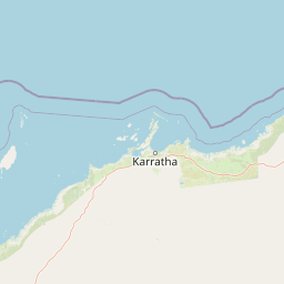
Map view of Montebello Islands Marine Park

Use this park location map to pinpoint Montebello Islands Marine Park in Australia, understand its exact geographic position, and read its mapped placement within the surrounding landscape more clearly.

Pigeon | © OpenStreetMap contributors

Location context for Montebello Islands Marine Park

Western Australia
Recorded earthquake history

Explore Recorded Earthquake History for Montebello Islands Marine Park

Examine the historical catalogue of seismic events recorded near the Montebello Islands Marine Park. This dataset organizes regional earthquake data to provide context on documented geological activity across these remote Western Australian waters.

Montebello Islands Marine Park Earthquake History

Catalogued events

2 events

Strongest magnitude

Magnitude 3.7

Most recent event

Mar 19, 2005

This history includes earthquakes recorded inside the park or within 50 km of its borders

Visual exploration of tropical reef systems, island lagoons, and marine habitats

Montebello Islands Marine Park Photos and Landscape Scenery

Photographic records reveal the distinct marine scenery and low island terrain defining the protected waters of Montebello Islands Marine Park. Visual documentation highlights the coral ecosystems, mangrove fringes, and remote offshore environments supporting regional biodiversity.

An oceanic whitetip shark swimming in clear blue water, approaching a white, cylindrical, perforated research bait canister mounted on a pole.

Park atlas

Compare adjacent marine reserves and regional coastal habitats in Western Australia

Exploring Parks Near Montebello Islands Marine Park and Surrounding Protected Areas

Browse nearby marine reserves and connected coastal protected areas extending along the Pilbara shelf. Comparing adjacent marine ecosystems provides deeper context for regional reef habitats and offshore conservation zones.
National parkPilbara
111 km away#1 closest

East

Murujuga National Park: Pilbara Region's Protected Natural Landscape

Explore mapped park boundaries and regional geography.

Murujuga National Park represents a vital protected territory within the Pilbara region of Australia. This page provides focused atlas information on the park's geographic scope, mapped terrain, and its significance as a national park. Understand the unique landscape context of Murujuga National Park and its place within the broader regional geography, offering detailed insights for geographic exploration.

Area
48.51 km²
Established
2013
Climate
Arid
Access
Moderate access
Marine protected areaWestern Australia
121 km away#2 closest

East

Dampier Marine Park: Geographic Overview and Marine Protected Area Mapping

Protected shelf ecosystems of the Pilbara coast, Western Australia

Dampier Marine Park spans a mosaic of shallow shelf waters near the Dampier Archipelago. This protected area integrates diverse management zones to support migratory pathways for marine megafauna and preserve benthic habitats across the Northwest Shelf Province. Understanding its boundaries provides insight into the intersection of conservation and marine spatial planning in one of Australia's most significant coastal bioregions.

Area
1,252 km²
Established
2018
IUCN
VI
Relief
Lowland
National parkWestern Australia
156 km away#3 closest

Southeast

Millstream Chichester National Park: A Mapped Protected Landscape in Western Australia

Explore its geographic spread and natural terrain features.

Millstream Chichester National Park is a designated national park within the vast geographic expanse of Western Australia. This entry provides detailed atlas-level information focused on its protected boundaries and distinct landscape characteristics. Understand the park's role within the regional geography and its significance as a mapped natural area for discovery and exploration.

Area
2,381.67 km²
Established
1970
IUCN
II
Relief
Mixed relief
Marine protected areaWestern Australia
176 km away#4 closest

Southwest

Gascoyne Marine Park: Protected Marine Geography and Seafloor Terrain Map

Marine protected area situated along the Western Australian coast

Gascoyne Marine Park encompasses a significant offshore region defined by its shallow continental shelf and varied seafloor structures. This protected marine area supports vital habitats for migratory species and contributes to the broader ecological network of the North-west Marine Parks system, offering a clear view of specialized aquatic environments through detailed mapping.

Area
81,766 km²
Established
2018
IUCN
IV
Relief
Lowland
Marine protected areaWestern Australia
176 km away#5 closest

Southwest

Ningaloo Marine Park: Mapping Western Australia's Protected Marine Geography and Habitats

Examining the oceanic shelf and reef environments of this key marine protected area

Ningaloo Marine Park safeguards a dynamic mosaic of shallow lagoons, reef edges, and deeper slope environments off the coast of Western Australia. This protected expanse is central to the regional conservation of whale shark feeding grounds and humpback whale migratory routes, offering a detailed perspective on the geomorphological character of the Central Western Shelf Transition.

Area
2,435 km²
Established
1987
IUCN
IV
Relief
Lowland
Watercolor illustration showing a coastal scene with shoreline, water, and landforms
National parkWestern Australia
210 km away#6 closest

Southwest

Cape Range National Park: Exploring Western Australia's Protected Landscape Identity

Mapped boundaries and regional geographic context.

Cape Range National Park is a vital protected area located in Western Australia, offering a distinct geographic profile for atlas exploration. This entry focuses on its identity as a national park, detailing its mapped landscape and regional context. Users can discover the park's place within the state's diverse terrain and understand its significance as a mapped conservation area, contributing to a structured understanding of Australia's protected lands.

Area
476.55 km²
Established
1965
IUCN
II
Relief
Highland
National parkAustralia
271 km away#7 closest

Southwest

Cape Range (South) National Park: Exploring Australia's Arid Semiarid Landscape Atlas

Mapped protected boundaries and regional terrain in Western Australia.

Cape Range (South) National Park, situated in Western Australia, is a vital protected area safeguarding a significant portion of the Carnarvon xeric shrublands. This national park offers a glimpse into a unique arid-zone landscape defined by low ranges, sandy plains, and characteristic acacia shrubland. Its establishment extends conservation efforts in the Gascoyne region, providing crucial context for mapped geography and the distribution of arid-adapted ecosystems within Australia's broader atlas.

Area
270.72 km²
Established
2020
IUCN
II
Relief
Upland
Marine protected areaWestern Australia
296 km away#8 closest

Northeast

Argo-Rowley Terrace Marine Park: Mapped Geography and Marine Protected Area Context

Expansive oceanic territory within the Western Australian region

Argo-Rowley Terrace Marine Park represents a vast offshore environment protecting diverse aquatic life and unique seafloor features. This marine protected area bridges the gap between the isolated Rowley Shoals and deep-water abyssal hills. The region is essential for understanding the structural geology of the ocean floor, encompassing everything from shallow reefs to abyssal plains in the remote north-west of Australia.

Area
146,003 km²
Established
2018
IUCN
VI
Relief
Lowland

Common questions about visiting, size, designation, and location context for Montebello Islands Marine Park

Montebello Islands Marine Park FAQs for park facts, access, geography, and protected area context

Find quick answers about Montebello Islands Marine Park, including protected-area facts, park geography, trail and visitor context, and how the park fits into its surrounding country and regional landscape.
MoriAtlas Explorer

Continue Your Protected Areas Search Across the Global Atlas

Deepen your exploration by continuing the structured search for national parks and protected areas worldwide. Utilize the comprehensive filtering capabilities to compare different conservation landscapes and refine your understanding of global park geography. Discover more about the distribution and characteristics of protected natural areas.

Global natural geography