Mori Atlas logo
Natural monumentMonumento natural Cueva Alfredo Jahn

Geographic analysis of an active limestone cave network within the Cordillera de la Costa

Monumento natural Cueva Alfredo Jahn: Mapping the Karst Landscapes and Cave Systems of Miranda

(Monumento Natural Cueva Alfredo Jahn)

Monumento natural Cueva Alfredo Jahn represents an extensive, hydrologically active limestone cave system spanning over four kilometers in the Miranda state of Venezuela. Carved into the Mesozoic Las Mercedes Formation by the Quebrada Cambural, this protected natural monument features complex horizontal galleries, large chambers like the Rain Hall, and diverse mineralogical formations. This analysis details the park's topography, subterranean passages, and its broader role within the coastal mountain range terrain.

cavekarstlimestone cavespeleologystalactitesstalagmites

Monumento natural Cueva Alfredo Jahn

Natural monument

Park overview

Structured park overview, official facts, and landscape profile for Monumento Natural Cueva Alfredo Jahn

Monumento Natural Cueva Alfredo Jahn park facts, protected area profile, and essential visitor context

Review the core facts for Monumento Natural Cueva Alfredo Jahn, including designation, size, terrain, visitor scale, habitats, and operating context in one park-focused overview.

About Monumento Natural Cueva Alfredo Jahn

Monumento Natural Cueva Alfredo Jahn protects a hydrologically active cave system set in the coastal mountains of north-central Venezuela. The monument lies within the state of Miranda, on the eastern edge of the Serranía Litoral of the Cordillera de la Costa, just inland from the Caribbean coast near the town of Birongo. Its setting is semi-scarp terrain of calcareous hills, with elevations ranging between roughly 60 and 300 meters above sea level, and a rainy tropical climate that sustains dense surrounding forest.

The cave is the principal feature of the protected area, and at about 4.29 kilometers of mapped horizontal galleries with a vertical relief of 67 meters, it is the largest cave of central Venezuela and the sixth largest in the country. Fifteen known entrances open into six distinct sectors that include the Galería de la Quebrada, the Arrastradero, the Galería del Río, the Codazzi Gallery leading to the famous Sala del Chaguaramo and Sala de la Lluvia, the Galería del Sifón del Diablo, and the Galería Henri Pittier. These passages range from roomy halls to low crawls and stream-crossed corridors, offering both scenic passages and genuine adventure terrain.

Geologically, the cave is carved into calcitic and calcitic-dolomitic marbles of the Mesozoic Las Mercedes Formation. The Quebrada Cambural, a perennial stream, infiltrates the rock for several hundred meters before resurfacing inside the cave system, and during the rainy season excess water continues over the surface into the cave, re-emerging at Boca 1. This continuous erosion and corrosion has produced a young cave system where active shaping dominates over the slower deposition of carbonate speleothems, although beautiful stalactites, stalagmites, and columns have still formed, reaching their greatest development in the Rain Hall.

Ecologically, the surrounding 58 hectares protect a dense pre-montane seasonally semi-deciduous forest with common species such as araguaney, indio desnudo, ramón, tuque, and palo de vaca. Frequent flooding inside the cave has limited the establishment of true cave-obligate fauna, but the system supports abundant insects and arachnids and important bat populations, including the common vampire bat. The monument is also notable for the cultural heritage of nearby Birongo, a historic Afro-Venezuelan community, and for the ongoing scientific research the cave has supported since its first exploration in 1952.

Quick facts and research context for Monumento Natural Cueva Alfredo Jahn

Cueva Alfredo Jahn is a Natural Monument located in Miranda state, Venezuela, about 4 km west of Birongo. It sits on the eastern end of the Serranía Litoral of the Cordillera de la Costa, between roughly 60 and 300 m above sea level, in a rainy warm climate with annual precipitation near 1,970 mm. The cave system has about 4.29 km of horizontal galleries, 67 m of vertical relief, fifteen entrances, and is divided into six sectors, and it is recognized as the largest cave of central Venezuela and the sixth largest in the country.

The protected area covers about 58 hectares and is administered by INPARQUES, with the eastern sector of Parque Nacional El Ávila (Waraira Repano) sharing oversight responsibilities. Decreed on December 12, 1978, in honor of scientist Alfredo Jahn, the monument protects one of the country's most visited caves, attracting an estimated 2,000 to 5,000 visitors per year.

Protection and recognition

Documented terrestrial protection scope, designation year, and international recognition records

Monumento natural Cueva Alfredo Jahn Protection Status and Designation History

Monumento natural Cueva Alfredo Jahn maintains a documented terrestrial protection status established in 1978. Structured facts outline the official designation history and management scope for this protected area.

Protection details

Protection scope
Terrestrial
Designated year
1978
Transboundary protection
No
Park context

Deeper park guide and search-rich context for Monumento Natural Cueva Alfredo Jahn

Monumento Natural Cueva Alfredo Jahn history, landscape, wildlife, and travel context

Explore Monumento Natural Cueva Alfredo Jahn through its history, landscape character, ecosystems, wildlife, conservation priorities, cultural context, and seasonal travel timing in a structured park guide built for atlas discovery and search intent.

Why Monumento Natural Cueva Alfredo Jahn stands out

Cueva Alfredo Jahn is best known as a young, hydrologically active limestone cave whose still-flowing Quebrada Cambural continues to sculpt and decorate its galleries. Its most celebrated feature is the Sala del Chaguaramo, also called the Rain Hall, where dense stalactites and a six-meter column shaped like the local Chaguaramo palm give the cave its signature appearance. Beyond its scenic formations, the cave is recognized for its mineralogical significance: rare minerals such as koktaite, ammoniojarosite, and manganberzeliite have been documented here, with some not reported in any other cave in the world. It is also notable for the bats that inhabit its dry sections and for the paleontological and paleoclimatological studies conducted on its stalagmites.

Monumento Natural Cueva Alfredo Jahn history and protected-area timeline

Cueva Alfredo Jahn was first scientifically explored in 1952 by the speleology section of the Sociedad Venezolana de Ciencias Naturales. Explorers Juan Antonio Tronchoni, Eugenio De Bellard, and Roberto Contreras reached the cave guided by local hunters who knew it by the older name Cueva de la Tapa de Cambural. They renamed it in honor of Alfredo Jahn, the Venezuelan engineer, explorer, and founder of the Sociedad Venezolana de Ciencias Naturales, who pioneered geography, geology, botany, astronomy, anthropology, linguistics, and several other scientific fields in the country.

The cave was later surveyed and officially registered in the National Speleological Cadastre by the Sociedad Venezolana de Espeleología in 1973. On December 12, 1978, it was decreed a Natural Monument through Decree No. 2,989, with the designation published in the Gaceta Oficial No. 2,417 on March 7, 1979. The decree recognized the cave as one of Venezuela's most significant karst features and aimed to protect its galleries, speleothems, and scenic value.

Since its protection, the monument has continued to attract research. Carlos Bordón produced the principal descriptive synthesis of the cave fauna as part of the 1973 cadastre, and Franco Urbani and collaborators later conducted studies on water chemistry and cave mineralogy. In the early 21st century, the cave's stalagmites have also been used in paleoclimatological studies, and the site has become an important case study in the epidemiology of histoplasmosis in South American caves.

Monumento Natural Cueva Alfredo Jahn landscape and geographic character

Cueva Alfredo Jahn occupies a semi-scarp landscape of low calcareous hills on the eastern end of the Serranía Litoral, the coastal range that runs parallel to the Caribbean in north-central Venezuela. Elevations within the protected area range from roughly 60 to 300 meters above sea level, and the surrounding terrain blends karst hills with the broader foothill slopes of the Cordillera de la Costa.

The cave's interior is the most distinctive landscape element. Horizontal galleries stretch for about 4.29 kilometers, and the system contains a varied sequence of passages: rooms like the Sala del Chaguaramo that open about 30 meters across, narrower crawlways such as the Arrastradero where visitors must crouch and slide, and stream-crossed sections like the Paso del Tremedal, where water can reach chest height. The signature feature is a six-meter column in the Rain Hall whose shape evokes the leaves of the local Chaguaramo palm.

Above ground, the landscape is shaped by tropical rainfall averaging nearly 1,970 mm per year and by perennial streams such as the Quebrada Cambural and the Quebrada Casupal. These waterways feed the cave system and carve the local marbles of the Las Mercedes Formation. Forests close to the cave are dense and seasonally semi-deciduous, with intermittent agricultural clearings and small rural settlements breaking up the wooded cover.

Monumento Natural Cueva Alfredo Jahn ecosystems, habitats, and plant life

The natural monument protects a roughly 58-hectare patch of pre-montane seasonally semi-deciduous forest that surrounds the cave. This forest is structured in three dense tree strata and supports common species such as araguaney, indio desnudo, ramón, tuque, and palo de vaca, which are typical of lowland and premontane forest communities in the Cordillera de la Costa.

Within the cave, ecological dynamics are shaped by the Quebrada Cambural. Frequent flooding has prevented the establishment of true cave-obligate species, so the subterranean fauna is dominated by troglophile and trogloxene organisms rather than fully cave-adapted species. The system nevertheless supports a rich assemblage of insects from at least six orders, including ants, beetles, flies, lacewings, hemipterans, and cockroaches, as well as spiders, at least two shrimp species, and an abundant population of bats whose guano supports an entire community of associated invertebrates.

The microclimate inside the cave is stable and warm, with interior temperatures between about 22°C and 26°C, and humidity is consistently high. These conditions, combined with the active hydrology, make the cave a living laboratory for studying how ongoing karst processes interact with surrounding tropical forest ecosystems.

Monumento Natural Cueva Alfredo Jahn wildlife and species highlights

Cueva Alfredo Jahn is notable for the richness of its cave fauna, even though the cave's active hydrology limits the development of species that complete their entire life cycle underground. The most prominent wildlife group is bats, with at least four species recorded, including the moustache bat, the funnel-eared bat, the greater spear-nosed bat, and the common vampire bat, which forms the largest colonies.

Insects are also abundant, with representatives of six orders documented, including ants, beetles, dipterans, lacewings, true bugs, and cockroaches. Arachnid diversity is similarly notable, with at least five orders represented and three spider species recorded, including species of the genera Priscula, Wendilgarda, and Achacaranea. At least two species of freshwater shrimp inhabit the Quebrada Cambural waters that flow through the cave.

The cave's bat colonies are concentrated in dry sections near entrances two, three, and four, where the floor is covered by important guano deposits. These deposits sustain the associated community of guano-loving invertebrates and are also relevant for the epidemiology of histoplasmosis, a fungal disease associated with bat and bird droppings.

Monumento Natural Cueva Alfredo Jahn conservation status and protection priorities

Cueva Alfredo Jahn was declared a Natural Monument in 1978 specifically to protect a karst system of national significance, including its multi-entrance structure, extensive galleries, and exceptional calcite formations. The monument is administered by INPARQUES, and oversight is shared with Parque Nacional El Ávila (Waraira Repano), whose eastern guard also monitors the cave.

The conservation significance of the site extends beyond its scenic formations. The cave system is still actively evolving through erosion and corrosion by the Quebrada Cambural, making it a valuable natural laboratory for karst science, mineralogy, and paleoclimatology. It has also yielded rare minerals not reported in other caves worldwide, and its bat fauna is ecologically important to the broader landscape.

Despite its protected status, the monument faces conservation challenges. The current boundaries do not fully cover the cave's hydrological catchment, agricultural expansion and deforestation in the Quebrada Cambural microbasin threaten to alter the cavemnation's groundwater flows, and there is concern about a decrease in stream discharge as forest cover is reduced. Recommendations have been made to expand Parque Nacional El Ávila into the cave's catchment, strengthen ranger presence, and develop monitored, small-group adventure tourism to minimize speleothem damage and graffiti impacts.

Monumento Natural Cueva Alfredo Jahn cultural meaning and human context

The cultural character of the area surrounding Cueva Alfredo Jahn is shaped by the town of Birongo, one of the most important centers of Afro-Venezuelan religious practice on the country's coast. Birongo originated as a cumbe, a settlement of escaped slaves who fled coastal cacao plantations and withdrew into the mountains, remaining isolated for long periods. This heritage is central to the regional identity of the cave's surroundings.

Local residents of the nearby hamlets of Casupal and La Oficina, both within the protected area, maintain traditional agricultural practices, cultivating cacao, ocumo, yuca, mapuey, yam, plantain, and banana. Until relatively recently, many local residents avoided the cave and did not know its recreational potential, reflecting long-standing cultural attitudes toward the underground environment.

Birongo is located in Municipio Brión, whose capital Higuerote is a coastal tourist hub with hotels and restaurants. The combination of Afro-Venezuelan cultural heritage, small-scale cacao cultivation, and proximity to the coast gives the cave's surroundings a distinctive cultural identity, even though the monument itself is primarily valued for its natural and scientific importance.

Top sights and standout views in Monumento Natural Cueva Alfredo Jahn

Cueva Alfredo Jahn offers a striking combination of geological activity, mineralogical rarity, and tropical forest setting. Its more than four kilometers of galleries, fifteen entrances, and well-defined sectors make it the most extensive cave in central Venezuela and one of the most adventurous underground sites in the country.

The Rain Hall and the Sala del Chaguaramo are the cave's signature spaces, where dense stalactites, stalagmites, and the iconic Chaguaramo column showcase the beauty of ongoing calcite deposition. Beyond the formations, the site attracts researchers for its rare minerals, its still-active Quebrada Cambural, its bat colonies, and its stalagmite-based paleoclimate record. For visitors, the cave provides a genuine small-group adventure experience within easy reach of the Afro-Venezuelan cultural landscape of Birongo.

Best time to visit Monumento Natural Cueva Alfredo Jahn

Cueva Alfredo Jahn is in a rainy tropical climate, so visits are typically most comfortable during the drier months of the year when stream levels inside the cave are lower and crawls such as the Paso del Tremedal are less likely to be flooded. The interior maintains a stable temperature of about 22 to 26 degrees Celsius regardless of season.

Because the cave is highly humid year round and has limited large chambers, small-group adventure visits are recommended regardless of when one goes. Visitors should plan to spend roughly four to five hours inside the cave during a connected traverse of its main sectors. Those interested in seeing the bat colonies most easily may prefer the dry sections near entrances two, three, and four, while rainy-season visits increase the experience of the cave's active hydrology but also raise flood risk in lower passages.
Monthly climate preview

Long-term temperature and monthly precipitation averages for representative coordinate sampling

Monumento natural Cueva Alfredo Jahn Climate Normals and Annual Weather Patterns

Monumento natural Cueva Alfredo Jahn records measured monthly temperatures ranging between 24.84 and 26.83 degrees Celsius alongside distinct precipitation variations across the annual cycle. Reviewing the complete twelve-month climatology dataset clarifies long-term baseline averages across the representative sample point.
Annual mean26 °C
25 °C27 °C
Jan25°
Feb25°
Mar25°
Apr26°
May27°
Jun26°
Jul26°
Aug26°
Sep27°
Oct27°
Nov26°
Dec26°
Warmest month
September

26.8 °C

Coolest month
February

24.8 °C

Wettest month
August

4.3 mm/day

Driest month
March

0.5 mm/day

Park location guide

Geography guide, regional context, and park location map for Monumento Natural Cueva Alfredo Jahn

Monumento Natural Cueva Alfredo Jahn park geography, regions, and map view in Venezuela

Understand where Monumento Natural Cueva Alfredo Jahn sits in Venezuela through a broader geographic reading of the surrounding landscape, nearby location context, and its mapped position within the national park landscape.

How Monumento Natural Cueva Alfredo Jahn fits into Venezuela

Venezuela is a country in northern South America with coastline along the Caribbean Sea and Atlantic Ocean. It borders Colombia, Brazil, Guyana, and Trinidad and Tobago. The country has an area of approximately 916,445 km² and a population of about 31.8 million. Caracas is the capital and largest city. Venezuela consists of 23 states and the Capital District.

Wider geography shaping Monumento Natural Cueva Alfredo Jahn in Venezuela

Venezuela is located on the northern coast of South America. The continental territory is bordered by the Caribbean Sea and Atlantic Ocean to the north, Colombia to the west, Brazil to the south, and Guyana to the east. Trinidad and Tobago lies to the northeast. The country includes various islands and islets in the Caribbean Sea known as the Federal Dependencies.

Map view of Monumento Natural Cueva Alfredo Jahn

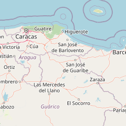
Use this park location map to pinpoint Monumento Natural Cueva Alfredo Jahn in Venezuela, understand its exact geographic position, and read its mapped placement within the surrounding landscape more clearly.

Pigeon | © OpenStreetMap contributors

Location context for Monumento Natural Cueva Alfredo Jahn

Miranda
Park atlas

Compare regional geography, coastal range terrain, and connected limestone landscapes

Explore Protected Areas and Parks Near Monumento natural Cueva Alfredo Jahn

Browse other parks and protected areas near Monumento natural Cueva Alfredo Jahn to examine broader regional geography and karst terrain. Comparing adjacent conservation landscapes provides valuable context on the tropical ecosystems of northern Venezuela.
Watercolor painting showing a winding river flowing through a landscape with rolling hills in the background
National parkVenezuela
About 0.6 km away#1 closest

West

El Ávila National Park: Venezuela's Premier Coastal Mountain National Park Exploration

Discover diverse terrain, mapped boundaries, and unique geographic context.

El Ávila National Park offers an exceptional gateway into Venezuela's mountainous protected landscapes. This national park features a dramatic rise from the Caribbean coast into varied terrain, including unique cloud forest and alpine zones. Its mapped geography showcases steep slopes, deep ravines, and remarkable elevation changes, providing a significant atlas-style study of coastal mountain environments. Exploring El Ávila National Park reveals a vital natural barrier and a rich ecosystem supporting diverse flora and fauna, making it a key destination for understanding regional protected areas.

Area
819 km²
Established
1958
IUCN
II
Relief
Mountain
Watercolor painting of a lagoon surrounded by green vegetation and mountains in the background
National parkMiranda State
About 39 km away#2 closest

Southeast

Laguna de Tacarigua National Park: Protected Area and Miranda State Geography

Mapped natural landscape and park boundaries in Venezuela.

Laguna de Tacarigua National Park is a designated national park offering critical protected landscape features within Miranda State. This park provides essential context for understanding Venezuela's protected areas, with a focus on its mapped boundaries and regional geographic setting. Dive into the atlas-style details to comprehend its place in the natural landscape.

Area
391 km²
Established
1974
IUCN
II
Relief
Lowland
National parkMiranda
About 48 km away#3 closest

South

Guatopo National Park: Venezuela's National Park Mapped Landscape Context

Discover Guatopo National Park's protected area geography.

Guatopo National Park represents a key protected natural landscape in Venezuela's Miranda region. This entry offers detailed geographic context, focusing on the park's mapped boundaries and its status as a national park. It is designed for users seeking structured information about protected areas, enabling a deeper understanding of natural landscapes and their regional distribution within an atlas framework. Explore the park's distinct protected-area identity and its place in the national geography.

Area
1,224.64 km²
Established
1958
IUCN
II
Relief
Mixed relief
Natural monumentGuárico State
About 78 km away#4 closest

Southwest

Monumento natural Morros de Macaira: Mapping the Karst Geology of Guárico State

Limestone massifs, vertical cliff profiles, and protected cavern networks.

Monumento natural Morros de Macaira features a distinct landscape dominated by three limestone massifs. These formations, characterized by sheer vertical cliffs and carved cavern systems, provide a unique geological footprint within the broader plains of Guárico State. The area acts as a vital transition point, sheltering montane vegetation and complex karstic structures that define its role in regional environmental conservation.

Area
0.99 km²
Established
1978
Relief
Upland
Access
Access unknown
National parkVenezuela
About 85 km away#5 closest

West

Macarao National Park: Venezuela's National Park with Mapped Boundaries and Regional Atlas Context

Explore its protected landscape and geographic setting within South America.

Delve into Macarao National Park, a significant national park situated in Venezuela. This page offers an atlas-centric view of the park, detailing its mapped boundaries and highlighting its importance within the regional geography of northern South America. Understand how Macarao National Park contributes to the country's network of protected landscapes and provides foundational geographic context for explorers and researchers.

Area
150 km²
Established
1973
IUCN
II
Relief
Mountain
Natural monumentAragua
About 113 km away#6 closest

West

Monumento Natural Pico Codazzi: Karst Landscapes and Mountain Corridors in Aragua

Exploring protected summit terrain and regional mountain connectivity

Spanning over 11,850 hectares, Monumento Natural Pico Codazzi preserves a complex mountain landscape defined by limestone massifs, vertical cliffs, and subterranean cave systems. Located in Aragua, this protected area functions as a biological bridge between major national parks, safeguarding a critical environment for migratory bird transit and high-altitude cloud forest stability across the Coastal Range.

Area
118.5 km²
Established
1991
Relief
Mountain
Climate
Tropical
Watercolor painting depicting mountains, a lake, and green vegetation
National parkVenezuela
About 124 km away#7 closest

West

Henri Pittier National Park: Venezuela's Oldest National Park, Coastal Range Geography

Explore protected landscapes, cloud forests, and birdwatching geography.

Henri Pittier National Park is Venezuela's foundational protected area, established in 1937 and spanning over 107,800 hectares within the Venezuelan Coastal Range. This national park is renowned for its exceptional biodiversity, particularly its over 500 bird species and its distinctive cloud forest ecosystems, which include the iconic Gyranthera caribensis tree. The park's geography extends from rugged mountain terrain to coastal bays and beaches, with the Paso de Portachuelo serving as a significant migratory bird corridor. Its mapped boundaries enclose a rich mosaic of natural landscapes vital for understanding regional conservation and protected area geography in northern South America.

Area
1,078 km²
Established
1937
IUCN
II
Relief
Mountain
National parkVenezuela
About 137 km away#8 closest

North

Archipiélago Los Roques National Park: Venezuela's Caribbean Marine Protected Landscape Explorer

Mapped coral reefs, protected islands, and Caribbean geography.

Archipiélago Los Roques National Park is a critical national park in Venezuela, safeguarding a remarkable archipelago in the Caribbean Sea. The park's landscape is defined by its vibrant coral reef systems, pristine white-sand beaches, and diverse marine habitats. Users can explore the geographic extent of this protected marine area, understanding its importance for conservation and its unique position within the southern Caribbean's natural geography.

IUCN
II
Climate
Tropical
Scope
Marine
Water
Water-dominated

Common questions about visiting, size, designation, and location context for Monumento Natural Cueva Alfredo Jahn

Monumento Natural Cueva Alfredo Jahn FAQs for park facts, access, geography, and protected area context

Find quick answers about Monumento Natural Cueva Alfredo Jahn, including protected-area facts, park geography, trail and visitor context, and how the park fits into its surrounding country and regional landscape.
MoriAtlas Explorer

Continue Your Protected Areas Search Across the Global Atlas

Deepen your exploration by continuing the structured search for national parks and protected areas worldwide. Utilize the comprehensive filtering capabilities to compare different conservation landscapes and refine your understanding of global park geography. Discover more about the distribution and characteristics of protected natural areas.

Global natural geography