
Mori Atlas logo
National parkMount Arayat National Park

Explore the mapped geography and protected boundaries of this Philippine natural landscape.

Mount Arayat National Park: Philippines National Park and Protected Landscape Atlas

Mount Arayat National Park stands as a significant protected area within the Philippines, offering a unique lens for geographic discovery. As a designated national park, its mapped boundaries define a protected landscape crucial for understanding the nation's diverse natural terrain. This entry provides an atlas-style context for Mount Arayat National Park, highlighting its role in the Philippines' broader geographic framework and inviting exploration of its unique natural features.

volcanic mountainsforest protectionCentral Luzonwatershed conservationPhilippines protected areastropical forest

Mount Arayat National Park

National park

Park overview

Structured park overview, official facts, and landscape profile for Mount Arayat National Park

Mount Arayat National Park park facts, protected area profile, and essential visitor context
Review the core facts for Mount Arayat National Park, including designation, size, terrain, visitor scale, habitats, and operating context in one park-focused overview.

About Mount Arayat National Park

Mount Arayat National Park protects a volcanic mountain and its surrounding landscape in the heart of Central Luzon, one of the Philippines' most productive agricultural regions. The park was established to conserve the natural forests and ecological resources of Mount Arayat, which serves as an important watershed for the surrounding farmland and communities. The mountain is an inactive stratovolcano that forms a prominent landmark visible across the flat terrain of Pampanga and adjacent provinces. The protected area encompasses the mountain's slopes from base to summit, preserving areas of tropical forest that provide habitat for native wildlife species and help maintain soil stability on the volcanic terrain. The park's establishment reflects recognition that even inactive volcanic landscapes require protection to preserve their ecological and watershed values.

Quick facts and research context for Mount Arayat National Park

Mount Arayat National Park is situated in Pampanga province, Central Luzon region of the Philippines. The protected area centers on Mount Arayat, an inactive volcanic mountain that stands as a prominent geographic feature in the otherwise flat terrain of the Central Luzon plain. The park was established to protect the mountain's forest cover, watershed values, and ecological biodiversity. The area features tropical forest vegetation on its slopes and supports various wildlife species native to the Luzon island ecosystem.

Park context

Deeper park guide and search-rich context for Mount Arayat National Park

Mount Arayat National Park history, landscape, wildlife, and travel context
Explore Mount Arayat National Park through its history, landscape character, ecosystems, wildlife, conservation priorities, cultural context, and seasonal travel timing in a structured park guide built for atlas discovery and search intent.

Why Mount Arayat National Park stands out

The park is best known for its protection of Mount Arayat, a distinctive volcanic peak that rises dramatically from the Central Luzon plains. The mountain's forested slopes and summit area represent a rare forested wilderness in an otherwise agricultural region, providing important ecological services including watershed protection and biodiversity conservation.

Mount Arayat National Park history and protected-area timeline

The specific establishment date and administrative history of Mount Arayat National Park are not fully detailed in available sources. Protected area status for Mount Arayat reflects broader Philippine conservation efforts to preserve remaining forest cover in heavily agricultural regions like Central Luzon. The mountain has long served as a cultural and geographic landmark for communities in Pampanga, with local communities having traditional associations with the area.

Mount Arayat National Park landscape and geographic character

The landscape of Mount Arayat National Park is defined by the volcanic mountain itself, which rises from the flat alluvial plains of Central Luzon. The mountain features forested slopes that transition from lowland vegetation near the base to montane forest at higher elevations. The terrain includes volcanic ridges, steep slopes, and a summit area that provides panoramic views of the surrounding agricultural landscape. The contrast between the forested mountain and the cultivated plain below creates a distinctive visual landscape characteristic of the region.

Mount Arayat National Park ecosystems, habitats, and plant life

The park protects tropical forest ecosystems on the slopes of Mount Arayat. Forest vegetation includes combinations of dipterocarp trees, secondary growth areas, and montane species at higher elevations. The protected area maintains ecological connectivity in a landscape otherwise dominated by agricultural land, serving as a refuge for forest-dwelling species and providing watershed functions that support downstream farmland and communities.

Mount Arayat National Park wildlife and species highlights

The forest cover on Mount Arayat provides habitat for various wildlife species typical of Luzon's tropical forests. While specific species documentation is limited in available sources, the protected area likely supports populations of birds, small mammals, and other fauna adapted to the mountain's forest habitats. The isolated forest ecosystem of the mountain serves as an important biodiversity refuge in the agricultural landscape of Central Luzon.

Mount Arayat National Park conservation status and protection priorities

Mount Arayat National Park represents an important conservation initiative in a region where agricultural expansion has reduced natural forest cover. The protected area helps preserve the mountain's watershed function, protecting water resources that support agricultural productivity in the surrounding plains. Forest protection on the volcanic slopes also helps prevent soil erosion and maintains soil stability on terrain that could be vulnerable to degradation if cleared.

Mount Arayat National Park cultural meaning and human context

Mount Arayat holds cultural significance for local communities in Pampanga province. The mountain appears in local traditions and folklore, and the area has historical associations with the region. The distinctive peak serves as a visual landmark that contributes to regional identity in Central Luzon.

Top sights and standout views in Mount Arayat National Park

The standout feature of Mount Arayat National Park is the mountain's prominence as a forested volcanic peak rising from the flat Central Luzon plain, creating a rare mountain wilderness in an otherwise agricultural landscape. The park provides important watershed protection for surrounding farmland while preserving forest habitat for native wildlife.

Best time to visit Mount Arayat National Park

The best time to visit Mount Arayat National Park corresponds to the Philippines' dry season, typically from November through May, when rainfall is reduced and conditions are more favorable for outdoor exploration of the mountain trails. The wet season from June to October brings heavier rainfall that can make trail conditions more challenging and viewpoints less accessible.
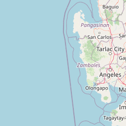

Park location guide

Geography guide, regional context, and park location map for Mount Arayat National Park

Mount Arayat National Park park geography, regions, and map view in Philippines
Understand where Mount Arayat National Park sits in Philippines through a broader geographic reading of the surrounding landscape, nearby location context, and its mapped position within the national park landscape.

How Mount Arayat National Park fits into Philippines

The Philippines, officially the Republic of the Philippines, is an archipelagic nation in Southeast Asia comprising approximately 7,641 islands categorized into three main geographical divisions: Luzon, Visayas, and Mindanao. Located in the western Pacific Ocean, it shares maritime borders with Taiwan, Japan, Palau, Indonesia, Malaysia, Vietnam, and China. Manila serves as the capital city, while Quezon City is the most populated city, both within Metro Manila.

Wider geography shaping Mount Arayat National Park in Philippines

The Philippines is an archipelagic nation in Southeast Asia, positioned in the western Pacific Ocean. Its islands are bounded by the South China Sea to the west, Philippine Sea to the east, and Celebes Sea to the south. The country shares maritime borders with Taiwan to the north, Japan to the northeast, Palau to the east and southeast, Indonesia to the south, Malaysia to the southwest, Vietnam to the west, and China to the northwest.

Common questions about visiting, size, designation, and location context for Mount Arayat National Park

Mount Arayat National Park FAQs for park facts, access, geography, and protected area context
Find quick answers about Mount Arayat National Park, including protected-area facts, park geography, trail and visitor context, and how the park fits into its surrounding country and regional landscape.
MoriAtlas Explorer

Continue Your Protected Areas Search Across the Global Atlas

Deepen your exploration by continuing the structured search for national parks and protected areas worldwide. Utilize the comprehensive filtering capabilities to compare different conservation landscapes and refine your understanding of global park geography. Discover more about the distribution and characteristics of protected natural areas.

Global natural geography