Mori Atlas logo
National parkMount Elgon National Park

Discover the mapped boundaries and unique geography of this transboundary national park.

Mount Elgon National Park: Uganda's Volcanic Protected Landscape and Atlas Entry

Mount Elgon National Park represents a significant protected landscape in Uganda, centered on the massive extinct shield volcano of Mount Elgon. This page provides detailed atlas-level information, focusing on the park's mapped boundaries, diverse vegetation zones from montane forest to afro-alpine moorland, and unique geological features like its famous cave systems. Understand the park's role as a vital watershed and a center of botanical diversity within East Africa's broader geographic context.

volcanic landscapetransboundary protected areaafro-alpine environmentmontane forestcave systemsmountain hiking

Mount Elgon National Park

National park

Park overview

Structured park overview, official facts, and landscape profile for Mount Elgon National Park

Mount Elgon National Park park facts, protected area profile, and essential visitor context

Review the core facts for Mount Elgon National Park, including designation, size, terrain, visitor scale, habitats, and operating context in one park-focused overview.

About Mount Elgon National Park

Mount Elgon National Park protects one of East Africa's most distinctive volcanic mountains, a massive shield volcano that straddles the Uganda-Kenya border. The park's transboundary nature presents both management challenges and opportunities for international conservation cooperation. The mountain rises from surrounding savanna to a series of peaks and cliffs, with the highest point on the Kenyan side reaching 4,155 meters at Koitoboss. The landscape is characterized by dramatic escarpments, deep gorges, and the distinctive volcanic plugs of Jackson's Peak and Endebess Bluff. Below the rocky summits, the mountain's slopes support forests that have been shaped by centuries of environmental change and more recent human activity. The park's cave systems, carved into the volcanic rock by millennia of erosion, represent a unique geological feature that also serves as an important ecological resource, providing mineral supplements for large mammals. Hot springs in the volcano's crater bubble at temperatures reaching 48 degrees Celsius, adding another dimension to the park's geothermal character.

Quick facts and research context for Mount Elgon National Park

Mount Elgon National Park lies approximately 140 kilometers northeast of Lake Victoria, with the nearest major town being Mbale in Uganda. The Kenyan portion was gazetted in 1968, while the Ugandan side achieved national park status in 1992. The park encompasses the western and eastern slopes of Mount Elgon, an extinct volcano reaching 4,155 meters at its highest peak, Koitoboss. The mountain's slopes are a critical watershed, feeding rivers that drain into both Lake Victoria and Lake Turkana. The park's vegetation ranges from wet montane forest through bamboo zones to high-altitude moorland, creating distinct ecological bands as elevation increases.

Protection and recognition

Verifying terrestrial conservation scope and transboundary park alignment within East Africa

Mount Elgon National Park Protection Status and UNESCO Biosphere Reserve Designation

Factual records compile the terrestrial protection status and transboundary conservation frameworks established for Mount Elgon National Park. Scholars and geographers can verify documented conservation designations, including the regional Mount Elgon UNESCO Biosphere Reserve integration.

International recognition

Protection details

Protection scope
Terrestrial
Designated year
2005
Transboundary protection
Yes
Core area
793.75 km²
Buffer area
327.42 km²
Park context

Deeper park guide and search-rich context for Mount Elgon National Park

Mount Elgon National Park history, landscape, wildlife, and travel context

Explore Mount Elgon National Park through its history, landscape character, ecosystems, wildlife, conservation priorities, cultural context, and seasonal travel timing in a structured park guide built for atlas discovery and search intent.

Why Mount Elgon National Park stands out

Mount Elgon National Park is best known for its extraordinary botanical diversity and unique cave systems. The mountain supports a remarkable series of vegetation zones, from Elgon olive and Aningeria wet montane forest at lower elevations through Afrocarpus and bamboo zones to heath-covered moorland at the summit. The park contains at least 400 plant species, including several that occur only in the high-elevation broadleaf montane forests here, such as Ardisiandra wettsteinii and Ranunculus keniensis. The four explorable caves, particularly Kitum Cave with its crystalline walls extending 200 meters into the mountainside, are famous not only for their geological beauty but also for the nocturnal visits by elephants and buffalo that come to lick natural salt from the cave walls. The park is also notable for its population of the endangered lammergeier (bearded vulture) and other restricted-range bird species.

Mount Elgon National Park history and protected-area timeline

The land around Mount Elgon was traditionally managed through indigenous power structures that regulated resource use on the communally owned upper elevations of the mountain. These traditional systems maintained sustainable use of natural resources until population pressures increased dramatically. Under British colonial administration, the Ugandan side was gazetted as a Forest Reserve in 1929, managed by the Forestry Department. The boundary survey was completed in 1937, though parcels were repeatedly degazetted to provide land for local residents. The area became the Mount Elgon Crown Forest in 1940 and a Central Forest Reserve in 1951. In 1983, the Ugandan government opened 6,000 hectares of the reserve for settlement by the Benet-Ndorobo group, with an additional 1,500 hectares settled illegally. This land was officially degazetted in 2002. During Uganda's civil conflicts, park management deteriorated significantly. In January 1994, the reserve was finally converted into a national park, though timber harvesting continued in some areas. The Kenyan portion was gazetted in 1968, establishing the modern protected area system.

Mount Elgon National Park landscape and geographic character

The physical landscape of Mount Elgon is dominated by the massive proportions of the extinct shield volcano, whose slopes radiate outward from a series of peaks and cliffs. The mountain's western flank features the dramatic free-standing volcanic plug of Jackson's Peak, rising to 4,165 meters beside Jackson's Pool at 4,050 meters. Endebess Bluff offers panoramic views of the surrounding escarpments, gorges, mesas, and rivers. The landscape includes dramatic cliffs, deep gorges carved by water flow, and the distinctive flat-topped mesas typical of eroded volcanic terrain. The cave systems, particularly Kitum Cave, represent remarkable geological features carved into the mountainside, with crystalline walls catching light in ways that have drawn visitors for generations. The crater contains hot springs that bubble with geothermal energy, reaching temperatures of 48 degrees Celsius. The terrain varies dramatically from the lower slopes, where the mountain rises from surrounding savanna, through the forested zones to the rocky summit areas and moorland.

Mount Elgon National Park ecosystems, habitats, and plant life

The ecological character of Mount Elgon is defined by its extraordinary elevation gradient and the corresponding zonation of vegetation types. The lower slopes are covered with Elgon olive and Aningeria wet montane forest, transitioning at higher elevations to olive and Afrocarpus forest, then to an Afrocarpus and bamboo zone dominated by Yushania alpina. Higher still, a Hagenia abyssinica zone gives way to moorland with heaths and tussock grasses. The giant lobelia (Lobelia telekii), groundsel (Dendrosenecio species), and heather create a distinctive afro-alpine character at the highest elevations. The botanical diversity is remarkable, with 400 species recorded including several endemics found only in the high-elevation broadleaf montane forest. African juniper, pillarwood, elderberry, and many orchid species add to the botanical richness. The climate is moist to moderate dry with annual rainfall exceeding 1,270 millimeters, supporting these diverse forest and moorland communities.

Mount Elgon National Park wildlife and species highlights

The mammal community of Mount Elgon includes large species such as elephants and buffalo that frequent the lower slopes and are famous for their nocturnal visits to the caves to obtain mineral salts. The park supports various antelope and duiker species, while the forest canopy is home to several primate species including black-and-white colobus, blue monkey, and red-tailed monkey, the latter reportedly rediscovered after being thought locally extinct. Predators present include leopard and hyena. The bird fauna is particularly noteworthy, with at least 144 species recorded. Of special conservation interest are Jackson's spurfowl, eastern bronze-naped pigeon, Hartlaub's turaco, Tacazze sunbird, and the endangered lammergeier, all of which have restricted ranges that make Mount Elgon an important stronghold. The invertebrate fauna includes Maathai's longleg, an endangered dragonfly discovered in 2005 and named after Nobel laureate Wangari Maathai. Remarkably, half of Uganda's butterfly species have been reported from Mount Elgon, indicating extraordinary invertebrate diversity.

Mount Elgon National Park conservation status and protection priorities

Mount Elgon National Park represents an important conservation area for both its unique species and its critical watershed function. The mountain's status as a major water catchment for rivers feeding both Lake Victoria and Lake Turkana gives it regional significance beyond its biodiversity value. The park's high-elevation endemic species, including several plants found only on Mount Elgon, make it important for botanical conservation. The presence of the endangered lammergeier and Maathai's longleg dragonfly adds to the conservation significance. However, the park faces significant challenges from historical encroachment, illegal settlement, and the legacy of civil conflict on the Ugandan side. The transboundary nature of the park requires coordination between Kenya Wildlife Service and Uganda Wildlife Authority for effective management. The cave systems, where elephants and other mammals contribute to cave formation through their salt-mining activities, represent a unique example of animal-mediated geological processes.

Mount Elgon National Park cultural meaning and human context

Mount Elgon holds cultural significance for the local communities who have historically depended on the mountain's resources. Before colonial administration, indigenous power structures and rules governed sustainable use of natural resources on communally owned upper elevations. The Benet-Ndorobo group has a particular historical connection to the mountain, with settlement issues creating ongoing management challenges. The mountain was named after the Elgon people, though the specific cultural associations vary between different ethnic groups in the region. Frederick Jackson, after whom Jackson's Pool and Jackson's Peak are named, was the first European to climb Mount Elgon in 1889, marking the beginning of systematic documentation of the mountain by outsiders. The caves have featured in literature, including parts of Richard Preston's The Hot Zone and possibly inspiring elements of King Solomon's Mines by Henry Rider Haggard.

Top sights and standout views in Mount Elgon National Park

The highlights of Mount Elgon National Park include the spectacular cave systems, particularly Kitum Cave with its crystalline walls, where elephants and buffalo come to lick salt at night. The hiking opportunities to Koitoboss Peak and Endebess Bluff offer access to panoramic views of the surrounding landscape. The unique vegetation zonation from forest through bamboo zones to afro-alpine moorland provides ecological interest. The wildlife, including elephants, buffalo, colobus monkeys, and the endangered lammergeier, adds to the park's appeal. The hot springs in the crater and the ancient cave paintings near Budadiri provide additional attractions. The transboundary character of the park, spanning Uganda and Kenya, offers a distinctive experience of international conservation cooperation.

Best time to visit Mount Elgon National Park

The climate of Mount Elgon features moist conditions with moderate dry periods, with annual rainfall exceeding 1,270 millimeters. The dry seasons run from June to August and from December to March, offering generally more favorable conditions for hiking and wildlife viewing. However, rain can occur at any time of year. The dry seasons provide clearer visibility for the panoramic views from Endebess Bluff and easier access to the higher elevation areas. The period from June to August corresponds to the northern hemisphere summer and is typically the most popular time for visitors. The wetter periods bring lush vegetation and full waterfalls but can make some trails more difficult. For cave exploration, the dry seasons offer more comfortable conditions for exploring the cave systems.

Monthly climate preview

Analyzing average temperatures and precipitation cycles at the representative mountain elevation of 1952 meters.

Mount Elgon National Park Monthly Weather Normals and Climate Patterns

Decades of climate measurements recorded at a representative elevation of 1952 meters show a moderate temperature regime with monthly means ranging from 16 to 20 degrees Celsius. Accessing the complete monthly profile provides historical weather by month, tracing daily precipitation averages and seasonal moisture patterns across the park landscape.
Annual mean18 °C
16 °C20 °C
Jan18°
Feb19°
Mar20°
Apr19°
May18°
Jun17°
Jul16°
Aug17°
Sep18°
Oct18°
Nov17°
Dec17°
Warmest month
March

19.8 °C

Coolest month
July

16.4 °C

Wettest month
May

7.1 mm/day

Driest month
January

1.4 mm/day

Park location guide

Geography guide, regional context, and park location map for Mount Elgon National Park

Mount Elgon National Park park geography, regions, and map view in Uganda

Understand where Mount Elgon National Park sits in Uganda through a broader geographic reading of the surrounding landscape, nearby location context, and its mapped position within the national park landscape.

How Mount Elgon National Park fits into Uganda

Uganda is a landlocked East African nation spanning approximately 241,000 km². It borders five countries and contains part of Lake Victoria, the world's second-largest freshwater lake. The country operates as a presidential republic with Kampala as its capital and largest city.

Wider geography shaping Mount Elgon National Park in Uganda

Uganda is situated in East Africa, bordered by Kenya to the east, South Sudan to the north, the Democratic Republic of the Congo to the west, Rwanda to the southwest, and Tanzania to the south. The southern portion includes a substantial part of Lake Victoria. The terrain features volcanic hills, mountains, and lakes.

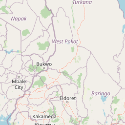
Map view of Mount Elgon National Park

Use this park location map to pinpoint Mount Elgon National Park in Uganda, understand its exact geographic position, and read its mapped placement within the surrounding landscape more clearly.

Pigeon | © OpenStreetMap contributors
Park atlas

Discover surrounding protected landscapes and compare regional park geography across East Africa, extending beyond the transboundary Mount Elgon.

Explore Other National Parks and Protected Areas Near Mount Elgon National Park

After exploring Mount Elgon National Park, browse other national parks and protected areas mapped within its surrounding East African geography, encompassing both Uganda and Kenya's connected landscapes. Compare diverse volcanic terrains, montane forests, and unique cave systems, gaining a broader atlas perspective on conservation efforts and regional park characteristics.
National parkTrans-Nzoia County
About 60 km away#1 closest

East

Saiwa Swamp National Park National Park: Mapped Protected Area in Trans-Nzoia County

Explore the geographic context and protected landscape features.

Saiwa Swamp National Park serves as a vital national park within Trans-Nzoia County, Kenya, offering a unique perspective on protected lands. This page details its mapped geography and landscape characteristics, providing essential context for atlas-based exploration of its protected boundaries and regional setting. Understand the specific features that define this important conservation area.

Area
3 km²
Established
1974
IUCN
II
Relief
Lowland
National parkNyanza Province
About 199 km away#2 closest

South

Ruma National Park: Kenya National Park within Nyanza Province Geographic Atlas

Explore its protected landscape and mapped geographic boundaries.

This MoriAtlas entry details Ruma National Park, a designated national park situated in Kenya's Nyanza Province. The focus is on its identity as a protected landscape, its specific geographic footprint, and its representation within a mapped atlas of natural areas. Users can investigate the park's terrain context, its regional placement, and the precise nature of its protected boundaries, offering structured geographic insight.

Area
120 km²
Established
1983
IUCN
II
Relief
Lowland
National parkKenya
About 230 km away#3 closest

Southeast

Lake Nakuru National Park: An Atlas of Kenyan Rift Valley Protected Landscapes

Geographic boundaries, terrain analysis, and ecosystem context.

Investigate the physical layout and protected status of Lake Nakuru National Park, a critical habitat located within Kenya's Great Rift Valley. This record details the park's alkaline lake basin, surrounding woodland transitions, and its broader role in regional conservation, providing a clear atlas perspective on one of the country's most significant natural protected areas.

Area
188 km²
Established
1961
Relief
Lowland
Climate
Subtropical
National parkRift Valley
About 235 km away#4 closest

Southeast

Lake Nakuru National Park: Geography and Protected Area Atlas Profile for Rift Valley

Mapped soda lake landscapes and rhino sanctuary boundaries

Lake Nakuru National Park is a prominent protected landscape situated in central Kenya, defined by its shallow alkaline lake and surrounding acacia forests. This profile explores the park's geographic footprint, including its role as a fenced sanctuary for rhinoceros and its location within the volcanic Rift Valley system. The terrain provides a clear study in how tectonic structures and water chemistry shape specialized habitats for large mammals and avian populations.

Area
188 km²
Established
1968
IUCN
II
Relief
Mixed relief
National parkMara Region
About 283 km away#5 closest

South

Serengeti National Park: National Park Atlas and Protected Landscape Discovery

Explore savanna grasslands, regional geography, and mapped park boundaries.

Serengeti National Park, a significant national park within Tanzania's Mara Region, offers an unparalleled view into a vast protected landscape. This page provides access to the park's geographic identity, its defining savanna ecosystem, and its role as a critical component of the regional atlas. Understand the mapped extent of its protected boundaries and the unique natural context that supports its renowned wildlife.

Area
14,763 km²
Established
1940
IUCN
II
Visitors
350K annual
Illustrated landscape with winding river, mountains, acacia trees, and green savannah
National parkKaramoja
About 292 km away#6 closest

North

Kidepo Valley National Park: Remote Protected Savannah Landscape in Karamoja

Explore Uganda's expansive national park mapped geography and wildlife

Kidepo Valley National Park represents a significant protected area within the Karamoja region of Uganda. Its rugged terrain features sweeping savannah plains, distinctive granite kopjes, and seasonal river systems, forming a unique geographic tapestry. This park is crucial for understanding the distribution of protected landscapes in East Africa, offering a distinct atlas perspective on its diverse ecosystems and wildlife concentrations across the mapped terrain.

Area
1,442 km²
Established
1958
IUCN
II
Visitors
2.3K annual
National parkNyeri County
About 295 km away#7 closest

Southeast

Aberdare National Park: Mapped Protected Landscape in Nyeri County

National Park Geography and Atlas Context

Aberdare National Park is a protected national park located within Nyeri County, Kenya. This entry offers detailed geographic information and map context, highlighting its protected boundaries and landscape characteristics. Users can explore its regional setting, understand its specific terrain features, and discover its significance as a conservation area within the Kenyan geography. Access structured data that clarifies the park's identity as a vital protected landscape.

Area
767 km²
Established
1950
IUCN
II
Relief
Mountain
National parkNakuru County
About 297 km away#8 closest

Southeast

Hell's Gate National Park: National Park Atlas and Mapped Landscape Exploration

Discover Nakuru County's protected terrain and geographic context.

Explore the mapped boundaries and unique geographic identity of Hell's Gate National Park, a protected national park within Kenya's Nakuru County. This detailed atlas view focuses on the park's natural landscape and its place within the regional geography, offering structured discovery of its protected terrain and surrounding context. Understand the visual and geographic essence of this significant conservation area.

Area
68.25 km²
Established
1984
IUCN
II
Relief
Mountain

Common questions about visiting, size, designation, and location context for Mount Elgon National Park

Mount Elgon National Park FAQs for park facts, access, geography, and protected area context

Find quick answers about Mount Elgon National Park, including protected-area facts, park geography, trail and visitor context, and how the park fits into its surrounding country and regional landscape.
MoriAtlas Explorer

Continue Your Protected Areas Search Across the Global Atlas

Deepen your exploration by continuing the structured search for national parks and protected areas worldwide. Utilize the comprehensive filtering capabilities to compare different conservation landscapes and refine your understanding of global park geography. Discover more about the distribution and characteristics of protected natural areas.

Global natural geography