Mori Atlas logo
Wildlife reserveMountain Lakes Wilderness

Explore the unique square boundary and high-altitude alpine lake networks of this southern Oregon wilderness.

Mountain Lakes Wilderness: A Geologic Atlas of Southern Cascade Volcanic Peaks and Glacial Basins

Mountain Lakes Wilderness encompasses a complex of four overlapping shield volcanoes in the southern Cascade Range of Oregon. This protected area stands out for its perfectly square administrative boundary and an interior terrain shaped by Pleistocene glacial activity. Over twenty distinct lakes now occupy the glacial cirques carved into the volcanic summits, creating a high-altitude landscape of sweeping ridgelines and enclosed alpine basins that reflect the region's ancient volcanic history.

southern Cascadesshield volcanoesglacial cirquesalpine lakeswilderness areaFremont-Winema National Forest

Mountain Lakes Wilderness

Wildlife reserve

Park overview

Structured park overview, official facts, and landscape profile for Mountain Lakes Wilderness

Mountain Lakes Wilderness park facts, protected area profile, and essential visitor context

Review the core facts for Mountain Lakes Wilderness, including designation, size, terrain, visitor scale, habitats, and operating context in one park-focused overview.

About Mountain Lakes Wilderness

Mountain Lakes Wilderness occupies a section of the southern Cascade Range where the typical Cascade pattern of volcanic cones and forested slopes gives way to a more open, lake-studded alpine environment. The area sits within the Fremont–Winema National Forest, and its identity is shaped by both the volcanic geology of the Cascades and the legacy of Pleistocene glaciation, which together produce the rugged skyline and basin-filled terrain that the wilderness protects.

The heart of Mountain Lakes Wilderness is a group of four overlapping shield volcanoes, a class of broad, gently sloped volcanic structures built by repeated flows of fluid lava. The tallest of these is Aspen Butte, whose summit reaches above 8,200 feet and defines much of the wilderness's high-country character. Surrounding these peaks are large cirque basins, the curved amphitheater-like hollows that glaciers carve into mountainsides. In Mountain Lakes, these cirques hold more than twenty lakes, ranging from small tarns to larger basin waters such as Harriette, Como, West, Mystic, Paragon, and South Pass Lakes. The combination of volcanic ridges falling into lake-filled glacial bowls gives the area a strongly mountainous but distinctive Cascade feel, quite different from the steep stratovolcanoes found farther north in the range.

Administratively, Mountain Lakes Wilderness is unique in the American wilderness system. Its boundaries are drawn as a perfect square, aligning precisely with the edges of a single survey township of roughly 36 square miles. No other designated U.S. wilderness area shares this geometric exactness, and the clean square outline has become a recognized geographic curiosity associated with the area.

Human use of the wilderness is deliberately limited to protect its wilderness character. The U.S. Forest Service maintains a small set of trails rather than a dense trail network, and recreational use centers on low-impact activities such as hiking, camping, fishing, and in winter, cross-country skiing. The area is reached from Klamath Falls and surrounding southern Oregon communities, and it offers visitors an experience that combines Cascade volcanic scenery with the quieter atmosphere of a glacially sculpted, lake-rich high country.

Quick facts and research context for Mountain Lakes Wilderness

Mountain Lakes Wilderness is a federally designated wilderness area of about 23,071 acres, located in the southern Cascade Range of Oregon within the Fremont–Winema National Forest. It was officially established on September 3, 1964, and is managed by the U.S. Forest Service. The wilderness is classified as IUCN Category Ib, recognizing its protected status as a true wilderness area.

The defining geographic feature of Mountain Lakes is a cluster of four overlapping shield volcanoes including 8,208-foot Aspen Butte. Glaciers during the Ice Age carved broad cirques near the volcanic summits, and these basins now hold more than twenty small lakes, giving the area both its name and its alpine character. The nearest city and main access hub is Klamath Falls, Oregon.

Protection and recognition

Terrestrial conservation scope, designation history, and administrative status facts

Mountain Lakes Wilderness Protection Status and Recognition Records

Mountain Lakes Wilderness holds a documented terrestrial protection scope within the regional conservation network. Administrative records outline current management parameters and official designation criteria for the protected area.

Protection details

Protection scope
Terrestrial
Transboundary protection
No
Park context

Deeper park guide and search-rich context for Mountain Lakes Wilderness

Mountain Lakes Wilderness history, landscape, wildlife, and travel context

Explore Mountain Lakes Wilderness through its history, landscape character, ecosystems, wildlife, conservation priorities, cultural context, and seasonal travel timing in a structured park guide built for atlas discovery and search intent.

Why Mountain Lakes Wilderness stands out

Mountain Lakes Wilderness is best known for its rare geologic pairing of overlapping shield volcanoes with glacially carved lake basins. The wilderness centers on Aspen Butte and its neighboring peaks, where Ice Age glaciers hollowed out broad cirques near the summits; today those bowls hold a string of small lakes, more than twenty in all, scattered across the high volcanic terrain. The wilderness is also famous among those familiar with U.S. protected areas for its perfectly square boundary. By aligning exactly with the lines of a single survey township, the area forms a unique footprint among American wildernesses, combining natural volcanic and glacial character with an unusually tidy administrative shape.

Mountain Lakes Wilderness history and protected-area timeline

Mountain Lakes Wilderness was formally established on September 3, 1964, when it was designated as part of the National Wilderness Preservation System. Its establishment added a significant block of high volcanic and glacial terrain in the southern Cascades to the growing federal network of lands set aside for their wilderness character.

The wilderness is administered by the U.S. Forest Service, and its setting within the Fremont–Winema National Forest reflects the broader pattern of Cascade protection, in which large national forest units manage both working forest landscapes and designated wilderness areas. The square external boundary corresponds to a single survey township, a remnant of the systematic land-survey grid used across much of the western United States, and gives the wilderness its distinctive shape on maps.

Since designation, the area has been managed with an emphasis on preserving its wilderness values, limiting road building, mechanized use, and development. Fish stocking in selected lakes has continued as part of managed recreational fishing, while trail access has been kept minimal to maintain a primitive, non-motorized experience for visitors.

Mountain Lakes Wilderness landscape and geographic character

The landscape of Mountain Lakes Wilderness is defined by the meeting of volcanic and glacial forces. The dominant features are four overlapping shield volcanoes, broad cones built up by successive lava flows rather than explosive eruptions. Aspen Butte, the tallest of these, rises above 8,200 feet and anchors the high country of the wilderness.

Cirques carved by Pleistocene glaciers ring the upper slopes of these volcanoes. These horseshoe-shaped basins, scooped out when enormous alpine glaciers ground into the mountain flanks, now form the floors that hold the lakes for which the area is named. More than twenty lakes lie in these glacial bowls, perched along the upper ridges and summits of the volcanic complex. The combination of shield-volcano slopes and steep cirque walls creates a terrain of long, sweeping ridgelines interrupted by sudden drops into lake-filled hollows.

Below the high country the volcanic slopes grade into forested terrain typical of the southern Cascades. Drainages such as Clover Creek and Varney Creek descend from the wilderness into the surrounding national forest. Because the highest lakes sit in glacially carved basins near the summits, the visual rhythm of the wilderness is one of open ridgelines, exposed rock and meadow, and sudden clusters of water that appear in the otherwise dry upper basins.

Mountain Lakes Wilderness ecosystems, habitats, and plant life

Ecologically, Mountain Lakes Wilderness combines elements of the southern Cascade Range's volcanic and montane systems. The upper elevations around the shield volcanoes and their glacial cirques support subalpine vegetation communities tolerant of short growing seasons, exposed rock, and winter snowpack. These high-country habitats sit above the denser conifer forests that clothe the lower slopes, creating a clear vegetation gradient from forested valleys up to open, rocky, alpine-influenced basins.

The chain of lakes within the cirques adds wetland and aquatic habitats to an otherwise relatively dry volcanic upland. These waters and their fringing meadows support aquatic invertebrates, fish where stocking has occurred, and surrounding plant communities adapted to cold, short summers.

The broader wilderness area, situated within the Fremont–Winema National Forest, sits in a transition zone between the more heavily forested Cascades to the north and the more open, drier landscapes toward the interior of southern Oregon. This transitional character, layered over volcanic and glacial terrain, gives Mountain Lakes a habitat mosaic that is distinct within the southern Cascades.

Mountain Lakes Wilderness wildlife and species highlights

Wildlife in Mountain Lakes Wilderness reflects the mixed subalpine and forested character of the southern Cascade Range. Mammals typical of Cascade forests, including deer and small carnivores, are present in the wooded slopes below the high country, while the open ridges and cirque basins provide habitat for wildlife adapted to rocky terrain and seasonal snow.

The lakes and their surrounding meadows attract waterfowl and other birdlife that use both the open water and the wet margins of the cirque basins. Raptors are associated with the higher, more exposed ridges and cliff edges around the shield volcanoes and cirques.

Fish populations in the lakes are an important element of the wilderness's wildlife profile. Brook trout and rainbow trout are stocked in selected lakes, including Harriette, Como, and West Lakes, which receive both species, while Mystic, Paragon, and South Pass Lakes receive only brook trout. Stocking occurs on a roughly alternate-year cycle and forms part of the recreational fishing experience in the wilderness.

Mountain Lakes Wilderness conservation status and protection priorities

Mountain Lakes Wilderness is protected primarily for its wilderness character and the distinctive combination of volcanic and glacial landforms it preserves. Its establishment in 1964 placed roughly 23,000 acres of high southern Cascade terrain into the National Wilderness Preservation System, where it receives the strong legal protections associated with that designation.

From a conservation standpoint, the area is significant for safeguarding a representative piece of the southern Cascade shield-volcano landscape, including the cirques and lakes formed during the Ice Age. By limiting road construction, mechanized travel, and large-scale development, the wilderness designation helps maintain its hydrological systems, subalpine vegetation communities, and wildlife habitat in a largely unmodified state. The clean, square boundary also makes the area a clear unit for long-term monitoring and land management.

Mountain Lakes Wilderness cultural meaning and human context

Mountain Lakes Wilderness sits within a region of southern Oregon with deep ties to the Cascade Range's natural resource history, including logging, grazing, and recreation traditions associated with the national forest system. The wilderness itself, however, is primarily valued for its natural and wilderness character rather than for built cultural landmarks.

Indigenous peoples historically occupied the broader southern Cascade region, including areas that now lie within the Fremont–Winema National Forest, and the surrounding landscape carries that longer human history. Detailed cultural information specific to the wilderness area itself is limited, and this context is therefore treated only in broad terms here.

Top sights and standout views in Mountain Lakes Wilderness

The signature highlights of Mountain Lakes Wilderness are its overlapping shield volcanoes, its twenty-plus glacial cirque lakes, and its unmistakable square boundary. Aspen Butte anchors the skyline, while lakes such as Harriette, Como, West, Mystic, Paragon, and South Pass fill the bowls around it.

A secondary set of highlights is the simplicity of its trail network, which keeps visitor use low-impact. Clover Creek, Mountain Lakes, and Varney Creek Trails provide access into a landscape that pairs classic Cascade forests below with an open, lake-dotted volcanic high country above.

Best time to visit Mountain Lakes Wilderness

Mountain Lakes Wilderness changes character meaningfully with the seasons. Summer is the most accessible period, when the high country is largely free of snow, the lakes are thawed, and the trails into the cirque basins are most safely traveled. This is also the main season for hiking and lake fishing, and the wildflower displays in the meadows around the lakes tend to peak in early to mid-summer.

Winter brings heavy snow to the higher elevations, which is why cross-country skiing is one of the recognized recreational activities in the area. Visitors in winter should expect snow-covered terrain, limited trail access, and conditions that require solid winter travel skills; in summer, visitors should expect cooler temperatures than in the surrounding lowlands and the possibility of sudden weather changes typical of the Cascades.

Monthly climate preview

Long-term representative averages tracking monthly temperature and precipitation cycles

Mountain Lakes Wilderness Climate Normals and Annual Temperature Rhythm

Historical data for Mountain Lakes Wilderness maps sustained annual shifts in monthly temperature ranges and precipitation rates from representative coordinates. Reviewing the complete twelve-month climatology provides deeper insight into measured long-term atmospheric patterns across the protected landscape.
Annual mean7 °C
-2 °C19 °C
Jan-2°
Feb
Mar
Apr
May
Jun13°
Jul19°
Aug18°
Sep15°
Oct
Nov
Dec-2°
Warmest month
July

19 °C

Coolest month
December

-1.9 °C

Wettest month
December

3.9 mm/day

Driest month
July

0.3 mm/day

Park location guide

Geography guide, regional context, and park location map for Mountain Lakes Wilderness

Mountain Lakes Wilderness park geography, regions, and map view in United States of America

Understand where Mountain Lakes Wilderness sits in United States of America through a broader geographic reading of the surrounding landscape, nearby location context, and its mapped position within the national park landscape.

How Mountain Lakes Wilderness fits into United States of America

The United States of America is a federal presidential republic and one of the world's largest countries by area and population. It consists of 50 states across a vast territory spanning multiple time zones, with its capital in Washington, D.C. and largest city in New York City. The nation has a diverse economy, influential political system, and significant cultural and military presence globally.

Wider geography shaping Mountain Lakes Wilderness in United States of America

The United States occupies a vast territory in North America, bordered by Canada to the north and Mexico to the south. The 48 contiguous states stretch from the Atlantic to the Pacific Ocean, while Alaska occupies the northwestern region and Hawaii is an archipelago in the Pacific. The country encompasses diverse terrain including the Rocky Mountains, Appalachian Mountains, Great Plains, and extensive river systems.

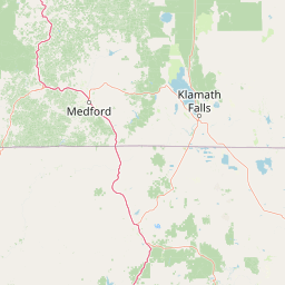
Map view of Mountain Lakes Wilderness

Use this park location map to pinpoint Mountain Lakes Wilderness in United States of America, understand its exact geographic position, and read its mapped placement within the surrounding landscape more clearly.

Pigeon | © OpenStreetMap contributors

Location context for Mountain Lakes Wilderness

Oregon
Recorded earthquake history

Review Recorded Earthquake Activity Near Mountain Lakes Wilderness

Access a detailed catalogue of historical seismic events associated by location with Mountain Lakes Wilderness. This MoriAtlas resource helps track documented earthquake records in the southern Cascades, offering a clear view of historical activity and epicentre proximity for this specific protected landscape.

Mountain Lakes Wilderness Earthquake History

Catalogued events

76 events

Strongest magnitude

Magnitude 6

Most recent event

Mar 24, 2013

This history includes earthquakes recorded inside the park or within 50 km of its borders

Park atlas

Compare adjacent volcanic terrain and connected regional wilderness zones

Parks Near Mountain Lakes Wilderness and Surrounding Protected Areas

Browse nearby national parks and protected areas sharing the volcanic and glacial characteristics of Mountain Lakes Wilderness. Extending the geographic review allows comparison of regional forest reserves and high elevation terrain across the southern Cascades.
An artistic watercolor illustration showing a line of green evergreen trees in the foreground with hazy, distant mountains in the background against a light, neutral sky.
Protected landscapeOregon
5.1 km away#1 closest

West

Rogue River, Siskiyou National Forest: Mapped Geography and Protected Area Overview

Tracing volcanic peaks and river-carved mountain terrain in Oregon

Spanning nearly 7,300 square kilometers, the Rogue River, Siskiyou National Forest acts as a crucial ecological anchor in the Pacific Northwest. This overview details its unique mountain geography, the extensive wilderness tracts within its boundaries, and the river systems that define its mountainous character.

Area
6,973.46 km²
Established
2004
Visitors
915K annual
Relief
Mountain
Protected landscapeCalifornia
39 km away#2 closest

South

Butte Valley National Grassland: Geographic Overview and Protected Landscape Mapping

High-desert sagebrush steppe in Northern California

Butte Valley National Grassland is a singular protected landscape in northern California, known for its expansive sagebrush steppe and dry lakebed terrain. Centered in the Klamath River basin, the grassland provides an essential high-desert habitat framed by the dramatic volcanic presence of the Cascade Range and Mount Shasta. This atlas entry details the geography, soil composition, and mountain-framed boundaries of this unique protected area.

Area
74.56 km²
Established
1991
Relief
Upland
Climate
Temperate
National parkOregon
42 km away#3 closest

North

Crater Lake National Park: Oregon National Park Atlas of Volcanic Landscapes

Explore mapped boundaries and unique caldera geography.

Crater Lake National Park represents a significant protected area within Oregon, defined by the dramatic volcanic caldera it contains. This national park is celebrated for its exceptionally deep, clear blue lake, formed by the collapse of Mount Mazama, offering a unique subject for geographic and landscape study. Users can explore its mapped boundaries and understand its position within the broader atlas of protected lands and mountainous terrain of the Cascade Range.

Area
741.48 km²
Established
1902
IUCN
II
Visitors
527K annual
Protected landscapeCalifornia
55 km away#4 closest

Southeast

Modoc National Forest: Protected Landscape and Warner Mountains Geography

High desert volcanic terrain in northeastern California

Modoc National Forest encompasses a massive expanse of volcanic plateaus and rugged mountain ridges in the northeastern corner of California. This protected area offers significant geographic variety, transitioning from arid sagebrush basins to lush, high-elevation conifer forests. It serves as a vital natural landscape, home to the South Warner Wilderness and large stands of old-growth timber, reflecting the unique geologic history of the regional lava flows.

Area
6,695.09 km²
Established
1904
Relief
Mountain
Access
Moderate access
Wildlife reserveOregon
68 km away#5 closest

North

Rogue-Umpqua Divide Wilderness: Protected Ridge Landscape and Watershed Geography

High-country wilderness area in southwestern Oregon

Rogue-Umpqua Divide Wilderness preserves a dense, high-elevation ridge environment that separates the Rogue and Umpqua river drainages. Featuring a complex mix of volcanic and sedimentary rock outcrops within a continuous conifer canopy, the area offers a unique look at forest ecology in the Klamath Mountains. The geography provides extensive views across both watersheds and stands as a primary example of protected montane forest terrain within the Oregon landscape.

Area
134 km²
Established
1984
IUCN
Ib
Water
Minor water
A watercolor illustration of rolling green hills, a small body of water, and distant mountain peaks against a plain white background.
Wildlife reserveOregon
79 km away#6 closest

North

Mount Thielsen Wilderness: Protected Volcanic Terrain and Glacial Landscapes in Oregon

Southern Cascade Range mountain and forest geography

Mount Thielsen Wilderness offers a compact yet dramatic study of southern Cascade topography. Dominated by its signature lightning-struck volcanic peak, the area encompasses a complex network of glacial cirques, deep valleys, and high-altitude forest zones. This map-rich entry point provides a closer look at the protected boundaries and natural geological features that define this significant segment of Oregon wilderness.

Area
223 km²
Established
1984
IUCN
Ib
Relief
Mountain
A soft watercolor painting depicting a serene landscape with gentle green hills, a small forest, and a calm lake at sunrise or sunset.
Protected landscapeCalifornia
82 km away#7 closest

South

Shasta, Trinity National Forest: Mapping the Protected Landscapes of Northern California

Volcanic peaks, expansive reservoirs, and rugged mountain wilderness

Spanning over two million acres, Shasta, Trinity National Forest represents a major protected landscape in Northern California. The geography includes the iconic Mount Shasta volcano and the complex shoreline of Shasta Lake, while hosting expansive wilderness areas and diverse terrain ranging from oak-forested foothills to alpine meadows.

Area
8,942.87 km²
Established
1954
Relief
Mountain
Climate
Temperate
A soft watercolor illustration depicting a series of distant mountain ranges behind a line of evergreen trees against a white background.
Wildlife reserveCalifornia
90 km away#8 closest

South

Mount Shasta Wilderness: A Geographic Profile of California Volcanic and Alpine Landscapes

Mapping protected volcanic peaks and glacial ecosystems

Deeply explore the protected geography of Mount Shasta Wilderness, a 38,200-acre reserve in Northern California. This record details the park's stratovolcano foundations, glacial terrain, and forested corridors, offering a clear view of the complex landforms and boundary systems that define this significant high-elevation protected area.

Area
155 km²
Established
1984
IUCN
Ib
Relief
Mountain

Common questions about visiting, size, designation, and location context for Mountain Lakes Wilderness

Mountain Lakes Wilderness FAQs for park facts, access, geography, and protected area context

Find quick answers about Mountain Lakes Wilderness, including protected-area facts, park geography, trail and visitor context, and how the park fits into its surrounding country and regional landscape.
MoriAtlas Explorer

Continue Your Protected Areas Search Across the Global Atlas

Deepen your exploration by continuing the structured search for national parks and protected areas worldwide. Utilize the comprehensive filtering capabilities to compare different conservation landscapes and refine your understanding of global park geography. Discover more about the distribution and characteristics of protected natural areas.

Global natural geography