Mori Atlas logo
Biosphere reserveMura-Drava-Danube

A transboundary protected landscape spanning dynamic river corridors and rich wetland ecosystems

Mura-Drava-Danube Biosphere Reserve: Mapping Central European River Floodplain Geography

The Mura-Drava-Danube Biosphere Reserve protects a vast, interconnected network of lowland river floodplains across the borders of Central Europe. This expansive protected area preserves dynamic river channels, sandbanks, oxbow lakes, and dense riparian forests that function as an essential corridor for biodiversity. Through careful mapping of its terrain and water-dominated features, this biosphere reserve remains a critical model for large-scale transboundary conservation.

transboundary biosphere reservewetlandsfloodplainriverine ecosystemsDanubeDrava

Mura-Drava-Danube

Biosphere reserve

Park overview

Structured park overview, official facts, and landscape profile for Mura-Drava-Danube

Mura-Drava-Danube park facts, protected area profile, and essential visitor context

Review the core facts for Mura-Drava-Danube, including designation, size, terrain, visitor scale, habitats, and operating context in one park-focused overview.

About Mura-Drava-Danube

Mura-Drava-Danube is a transnational biosphere reserve built around the lower reaches of the Mura and Drava rivers and a stretch of the Danube, with its core areas concentrated along the Croatia-Hungary border. Covering roughly 631,460 hectares, the reserve is one of the largest protected wetland complexes in Central Europe. It is not a single continuous park in the traditional sense, but a coordinated network of national parks, nature parks, and Natura 2000 sites managed jointly across international boundaries.

The reserve's defining feature is its connectivity. Flood prevention dams along the rivers divide the wider landscape into a seasonally flooded zone and a flood-protected zone, but the system as a whole retains ecological functions that have largely vanished from regulated European rivers. Natural river dynamics, including shifting channels, sediment transport, and seasonal inundation, continue to shape forests, meadows, and aquatic habitats. As a result, the reserve preserves large-scale ecological processes alongside individual species and habitats, something relatively rare in European conservation.

Beyond its ecological role, Mura-Drava-Danube represents a long-term model of transboundary conservation. It emerged from cooperation among five countries (Austria, Slovenia, Croatia, Hungary, and Serbia) and was officially designated by UNESCO in 2017 under the UNESCO title Bačko Podunavlje. The reserve combines biodiversity protection with sustainable economic development, organic production, tourism, and the protection of cultural heritage in each participating country. Today it stands as a flagship example of how international cooperation can scale up conservation across Europe's most heavily modified river landscapes.

Quick facts and research context for Mura-Drava-Danube

Mura-Drava-Danube is a UNESCO Biosphere Reserve spanning approximately 6,300 square kilometres across Croatia and Hungary. It follows the Mura, Drava, and Danube rivers, and is best described as a landscape-scale wetland and floodplain reserve rather than a single contiguous park. Its heart includes existing protected areas such as Kopački rit in Croatia and the Danube-Drava National Park in Hungary, with connected Natura 2000 sites extending into Austria, Slovenia, and Serbia. The reserve is widely known as the Amazon of Europe because of its exceptional riverine and forest floodplain character.

Protection and recognition

Documented transboundary designation history and conservation scope

Mura-Drava-Danube Protection Status and International Recognition Data

Terrestrial protected area records for Mura-Drava-Danube outline established 2016 designation timelines and formal transboundary status. Official recognition datasets detail international biosphere reserve listings and documented management frameworks.

International recognition

Protection details

Protection scope
Terrestrial
Designated year
2016
Transboundary protection
Yes
Core area
665.88 km²
Buffer area
850.98 km²
Park context

Deeper park guide and search-rich context for Mura-Drava-Danube

Mura-Drava-Danube history, landscape, wildlife, and travel context

Explore Mura-Drava-Danube through its history, landscape character, ecosystems, wildlife, conservation priorities, cultural context, and seasonal travel timing in a structured park guide built for atlas discovery and search intent.

Why Mura-Drava-Danube stands out

Mura-Drava-Danube is most recognised for preserving a vast, still-functioning network of Central European river floodplains. The reserve protects dynamic river channels, oxbow lakes, sand and gravel bars, willow and poplar forests, and seasonally flooded meadows that have been heavily altered or destroyed elsewhere in the Danube basin. It is also known as the Amazon of Europe, a nickname reflecting both the scale of the wetland system and the perception that it remains one of Europe's best-preserved river wildernesses. The reserve is equally well known for being a major stronghold for birds, fish, and other wetland wildlife. Its mosaic of aquatic, marsh, and forest habitats hosts internationally important populations of breeding, wintering, and migratory species, and the rivers themselves remain relatively undisturbed spawning grounds in a region where most lowland rivers have been heavily regulated. This combination of intact river morphology, large floodplain forests, and high biodiversity is what most strongly defines the reserve.
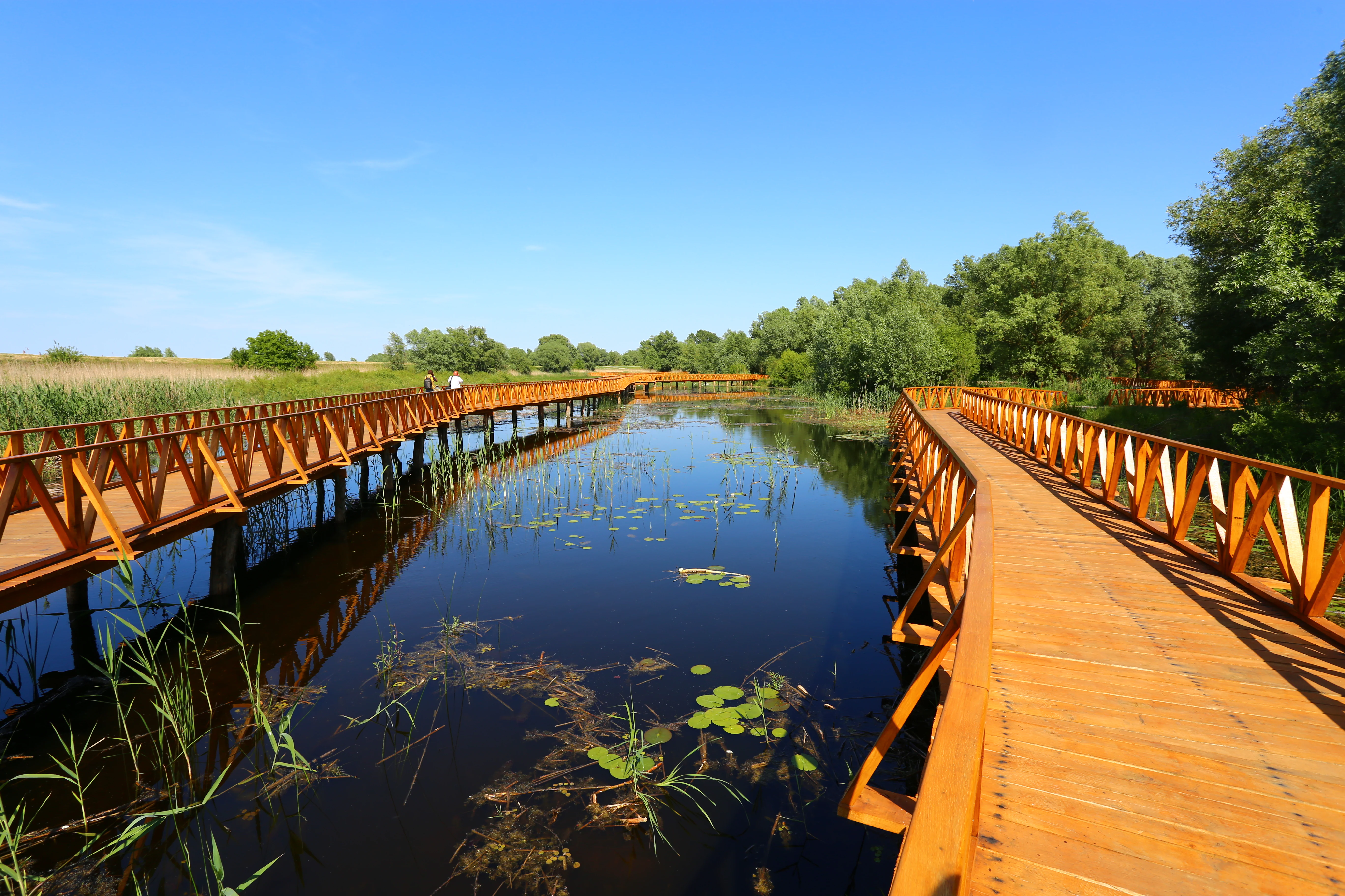
A bright orange wooden boardwalk extends over dark wetland water, with lush green trees and reeds in the background under a clear blue sky.
A wooden boardwalk path winds through the wetlands of Kopački rit.

Mura-Drava-Danube history and protected-area timeline

The idea of a large, cross-border protected area along the Mura, Drava, and Danube rivers developed over more than a decade of regional cooperation. In 2009, a preliminary bilateral agreement between Croatia and Hungary laid the groundwork for creating a joint natural reserve in the Drava-Danube region. By March 2011, environment ministries from five countries (Austria, Slovenia, Croatia, Hungary, and Serbia) had agreed on the creation of a Trans-boundary Biosphere Reserve that would encompass existing protected areas, buffer zones, and transitional zones linked to the rivers.

The plan envisioned a reserve made up of more than 700 square kilometres of core zone, around 2,300 square kilometres of buffer zones, and roughly 7,000 square kilometres of transitional zones, for a combined area of approximately 10,000 square kilometres. It incorporated established protected areas such as Kopački rit and Veliki Pažut in Croatia, the Danube-Drava National Park in Hungary, and Gornje Podunavlje, Karađorđevo, and Tikvara in Serbia, along with related Natura 2000 sites in Austria, Slovenia, and Hungary. Because of its scale and ecological character, the project was nicknamed the Amazon of Europe.

In June 2016, UNESCO officially designated the reserve, and in September 2016, five ministers formally opened it and agreed on future cooperation and joint management. The reserve was subsequently confirmed as a UNESCO Biosphere Reserve on 14 June 2017 under the title Bačko Podunavlje. Today, the Croatian portion is administered by Croatia's Ministry of Culture, while the Hungarian portion is overseen by the Danube-Drava National Park Directorate.

Mura-Drava-Danube landscape and geographic character

The landscape of Mura-Drava-Danube is shaped almost entirely by large lowland rivers and their floodplains. The Mura, Drava, and Danube each carve wide corridors through the Pannonian Plain, leaving a mosaic of active channels, abandoned meanders, oxbow lakes, sand and gravel bars, river islands, and low terraces. Vegetation hugs the natural moisture gradient, creating a layered patchwork of aquatic habitats, reedbeds, wet meadows, willow and poplar floodplain forests, and more stable hardwood stands on higher ground.

Flood prevention infrastructure strongly influences how the landscape functions. Dams along the rivers split the reserve into a naturally flooded side, where seasonal inundation continues to restructure habitats, and a flood-protected side, where land use and forests have stabilised over many decades. The result is a landscape that still feels dynamic and wild along the active rivers, while also including long-established rural and forest areas in the protected side. Dramatic features include large meander cutoffs, shifting gravel banks that act as natural breeding grounds for birds and fish, and broad stands of riparian forest that stretch for kilometres along the river corridors.

This is not a mountainous or coastal landscape. Instead, Mura-Drava-Danube offers an expansive, flat, river-dominated scenery defined by water, sediment, and forest. The visual character ranges from open, braided river channels with light-coloured gravel through dense, dark riparian woodland to wide marshlands and open water surfaces, all reinforcing the reserve's nickname as the Amazon of Europe.

Mura-Drava-Danube ecosystems, habitats, and plant life

Mura-Drava-Danube protects one of the most ecologically significant floodplain-wetland systems in the Danube basin. The reserve combines still-functioning river dynamics with extensive wetland and forest habitats, supporting an unusually high concentration of aquatic, semi-aquatic, and forest species. The combination of flowing rivers, standing oxbow waters, marshes, wet meadows, and floodplain forests gives the area a layered ecological structure that is increasingly rare in heavily regulated Central European lowlands.

Ecological processes remain a central part of the reserve's identity. Seasonal flooding redistributes nutrients, creates new sandbars and gravel bars, and rewrites forest edges along the river corridors. These processes support characteristic riparian vegetation, including willow and poplar-dominated softwood forest on younger alluvial soils and mixed hardwood floodplain forest on more stable ground. Where land use is more controlled, traditional grassland and wetland communities survive alongside the wilder core areas, increasing overall habitat diversity.

Because the reserve integrates multiple national parks, nature parks, and Natura 2000 sites, ecological management is coordinated at a landscape scale. Nature protection, water management, and sustainable land use are linked together to maintain biodiversity while recognising that much of the area has a long history of human use. The aim is to preserve ecological functions, including natural river dynamics, across a much larger area than any single protected area within the reserve could achieve on its own.

Mura-Drava-Danube wildlife and species highlights

Mura-Drava-Danube is an internationally important area for wetland and riverine wildlife. The reserve's combination of braided rivers, oxbows, reedbeds, and floodplain forest supports large populations of fish, amphibians, reptiles, mammals, and especially birds. The region's intact river channels and gravel banks make it a particularly valuable refuge for species that depend on dynamic, unmodified river systems, which have largely disappeared elsewhere along the Danube and its tributaries.

The reserve is a major site for waterbirds and birds of prey, with the river corridors, oxbows, and reedy marshlands offering breeding, wintering, and stopover habitat for migratory and resident species. Mammals associated with intact floodplain environments from the region, including species linked to large reedbeds, wet meadows, and old riparian forest, are also supported here. The rivers themselves remain ecologically functional spawning and nursery areas for freshwater fish, reinforcing the reserve's significance for aquatic biodiversity.

Although the source material does not provide explicit species lists, the reserve's overall design consolidates existing national parks and Natura 2000 sites that together represent one of the strongest concentrations of protected wetland and river wildlife in the Danube basin. The wildlife value of Mura-Drava-Danube is closely tied to the continued presence of natural river processes, seasonal flooding, and connected floodplain habitats, rather than to any single flagship species.

Mura-Drava-Danube conservation status and protection priorities

Mura-Drava-Danube is a flagship example of large-scale, transboundary wetland conservation in Europe. Its core conservation significance lies in the preservation of intact river and floodplain processes across an area spanning more than 6,300 square kilometres, far larger than most traditional protected areas in the region. By uniting existing national parks, nature parks, and Natura 2000 sites into a single biosphere reserve framework, the area secures ecological connectivity that no individual site could maintain alone.

UNESCO Biosphere Reserve status, attained in 2017 under the title Bačko Podunavlje, recognises the reserve as a model for combining biodiversity protection, sustainable development, and cultural heritage conservation. Management explicitly integrates ecological objectives such as renewing and protecting natural wetlands and biodiversity with socio-economic goals including organic agriculture, sustainable tourism, drinking water protection, and the preservation of diverse cultural traditions across the participating countries.

The reserve also illustrates the conservation importance of leaving floodplain dynamics intact. The split between flooded and flood-protected zones allows natural river processes to continue shaping core areas while supporting traditional land use elsewhere, providing a working example of how to reconcile ecosystem functioning with human activity in heavily populated lowland Europe.

Mura-Drava-Danube cultural meaning and human context

Mura-Drava-Danube reflects a long history of human interaction with large Central European rivers. The floodplain landscapes it protects have supported traditional agriculture, fishing, forestry, and river-based transport for centuries, and the region's communities retain distinct cultural traditions tied to floodplain life. The reserve's management explicitly recognises this heritage and includes the protection of diverse cultural traditions alongside ecological conservation.

The transboundary character of the reserve is itself a cultural statement. It pools expertise and conservation responsibility across five countries (Austria, Slovenia, Croatia, Hungary, and Serbia), and symbolises a regional effort to preserve a shared natural and cultural inheritance. The UNESCO title Bačko Podunavlje reflects this regional identity, drawing on the local Slavic word Podunavlje, meaning the Danube region.

Top sights and standout views in Mura-Drava-Danube

Mura-Drava-Danube stands out for combining vast scale with genuinely intact river and floodplain dynamics, anchored by recognised sites such as Kopački rit in Croatia and the Danube-Drava National Park in Hungary. The reserve offers some of Europe's best-preserved braided river sections, extensive willow and poplar floodplain forests, and large oxbow and marsh complexes that support internationally important waterbird populations. Its nickname, the Amazon of Europe, captures both the area's scale and the perception that it behaves more like a wilderness than a traditional park.

The reserve is equally notable as a global model for transboundary conservation. Its UNESCO Biosphere Reserve designation and coordinated management across five countries demonstrate how ecological connectivity, sustainable regional development, and cultural heritage protection can be pursued together across national borders.

Best time to visit Mura-Drava-Danube

The Mura-Drava-Danube reserve changes character meaningfully with the seasons, shaped by river dynamics, flooding cycles, and bird migration. Spring and early summer are especially notable for elevated water levels, active floodplains, lush riparian vegetation, and a wide variety of breeding and migrant birdlife. Wetland and river conditions are most dynamic in months when snowmelt and rainfall feed the rivers, which can also mean that some floodplain paths and trails are temporarily inaccessible.

Late summer and early autumn tend to produce lower water levels, more accessible gravel banks, and stable conditions for walking along rivers and through riparian forests. Winter brings quieter landscapes, concentrations of waterfowl, and clear views across open floodplain meadows and river channels, though weather along the Pannonian lowlands can be cold. Across all seasons, the reserve's character is shaped more by water levels and seasonal ecology than by dramatic changes in scenery.
Monthly climate preview

Long-term representative temperature and precipitation rhythms across twelve months

Mura-Drava-Danube Climate Normals and Measured Annual Weather Patterns

Representative coordinate records show measured monthly temperature variations spanning sub-zero winter minimums to high summer maximums alongside consistent precipitation rates. Examining the complete monthly climate profile reveals detailed long-term temperature and moisture distributions for Mura-Drava-Danube.
Annual mean12 °C
-1 °C24 °C
Jan-1°
Feb
Mar
Apr12°
May17°
Jun21°
Jul24°
Aug24°
Sep18°
Oct12°
Nov
Dec
Warmest month
July

23.7 °C

Coolest month
January

-0.7 °C

Wettest month
June

2.4 mm/day

Driest month
January

1.3 mm/day

Park location guide

Geography guide, regional context, and park location map for Mura-Drava-Danube

Mura-Drava-Danube park geography, regions, and map view in Croatia

Understand where Mura-Drava-Danube sits in Croatia through a broader geographic reading of the surrounding landscape, nearby location context, and its mapped position within the national park landscape.

How Mura-Drava-Danube fits into Croatia

Croatia is a unitary parliamentary republic located in Central and Southeast Europe along the Adriatic Sea. With an area of approximately 56,600 km² and a population of nearly 3.9 million, it is a member of the European Union and uses the Euro as its currency. Zagreb serves as both the capital and largest city.

Wider geography shaping Mura-Drava-Danube in Croatia

Croatia is located in Central and Southeast Europe, bordering Slovenia and Hungary to the northwest and northeast respectively, Serbia to the east, Bosnia and Herzegovina and Montenegro to the southeast, with a maritime border with Italy to the west. The country occupies the eastern shores of the Adriatic Sea and spans the Dinaric Alps, Pannonian plain, and coastal islands.

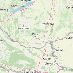
Map view of Mura-Drava-Danube

Use this park location map to pinpoint Mura-Drava-Danube in Croatia, understand its exact geographic position, and read its mapped placement within the surrounding landscape more clearly.

Pigeon | © OpenStreetMap contributors

Explore floodplain habitats, riparian forests, and dynamic river channels through park photography.

Mura-Drava-Danube Photos and Scenery: Visualizing Central Europe River Landscapes

Visual documentation reveals the intricate network of braided river channels, oxbow lakes, and expansive willow forests that define the lowland reserve. Examining these protected landscapes helps researchers and visitors understand the natural flood dynamics and rich wetland habitats of the Danube basin.

A bright orange wooden boardwalk extends over dark wetland water, with lush green trees and reeds in the background under a clear blue sky.

Park atlas

Compare adjacent river corridors, lowland floodplains, and regional transboundary reserves

Parks Near Mura-Drava-Danube and Connected Protected Landscapes

Browsing parks near Mura-Drava-Danube reveals broader ecological networks across Central European river basins. Comparing related protected areas expands regional geography understanding beyond single wetland corridors.
A watercolor painting showing a winding river through a flat, green landscape with clusters of trees and soft, rolling hills in the background.
Nature reserveHungary
About 13 km away#1 closest

North

Gemenc Nature Reserve, A Protected Danube Floodplain Landscape in Hungary

Explore the geography of alluvial forests and river-fed wetlands

Gemenc stands as a testament to natural floodplain dynamics, stretching along the Danube in southern Hungary as a vast corridor of alluvial woodland. The protected area encompasses a rich variety of riverine terrain, including meandering oxbows, islands, and diverse forest mosaics that host significant animal populations. Utilize this geographic reference to understand the landscape context and natural boundaries of one of the most prominent wetland reserves in the Carpathian Basin.

Area
340 km²
Established
1977
Relief
Lowland
Climate
Temperate
Watercolor illustration of a river flowing through wetland vegetation with distant hills under a light sky
Protected landscapeOsijek-Baranja County
About 18 km away#2 closest

South

Kopački Rit Protected Landscape: A Key European Wetland Ecosystem in Osijek-Baranja County

Mapped natural terrain and protected landscape geography.

Delve into the protected landscape of Kopački Rit, a pivotal European wetland situated within Osijek-Baranja County, Croatia. This page offers a detailed look at its dynamic floodplain ecosystem, mapped water channels, marshes, and riparian forests, highlighting its importance for biodiversity and regional geography. Understand the park's extensive protected boundaries and its place in the broader continental atlas.

Area
177 km²
Established
1976
IUCN
V
Relief
Lowland
Watercolor illustration of a river landscape with grassy banks, trees, and hills in the background
National parkHungary
About 36 km away#3 closest

North

Danube-Drava National Park: Hungary's Premier Riverine Protected Area and Floodplain Landscape

Mapping the protected river corridors and vital wetland ecosystems

Danube-Drava National Park showcases the dynamic geography of Central Europe's largest riverine protected area, integrating floodplains, riparian woodlands, and extensive marshes along the Danube and Drava rivers. As a National Park and a Ramsar site, it protects crucial habitats like the Gemenc forest and supports exceptional biodiversity, including significant populations of white-tailed eagles. This page provides a structured overview of its mapped boundaries and ecological importance within the European protected lands atlas.

Area
490 km²
Established
1996
IUCN
II
Relief
Lowland
Watercolor illustration of a winding river through grassy fields with wildflowers and distant hills
Protected landscapeSerbia
About 65 km away#4 closest

Northeast

Subotička Peščara Protected Landscape: A Mapped Inland Dune System in Serbia

Explore unique Pannonian Plain geography and rare habitats.

Subotička Peščara Protected Landscape offers a deep dive into an exceptional inland dune ecosystem, a key feature of Serbia's Pannonian Plain geography. This protected area's mapped terrain includes a mosaic of forest, steppe, and wetland habitats, supporting rare flora and fauna. Discover the unique contours of this aeolian landscape and its significance within the regional geographic context.

Area
53.7 km²
Established
2002
IUCN
V
Relief
Lowland
Watercolor illustration of Lake Palić showing a body of water with green and pink trees on the shore, rolling hills in the background
Protected areaSerbia
About 65 km away#5 closest

East

Lake Palić Protected Area: Serbia's Mapped Landscape and Regional Geography Exploration

Understand the protected landscape and park boundaries of Lake Palić.

Delve into the specifics of Lake Palić, a designated protected area in Serbia. This resource offers a deep dive into the park's mapped landscape, helping to illustrate its protected boundaries and geographic significance. Gain a clear understanding of its regional context and its contribution to the atlas of protected natural areas within Serbia.

IUCN
IV
Watercolor painting of rolling hills, green fields, and a winding path
National parkHungary
About 73 km away#6 closest

North

Kiskunság National Park: Explore Hungary's Puszta Grassland and Unique Sand Dune Terrain

Discover protected landscapes, alkaline lakes, and bird habitats.

Kiskunság National Park in Hungary offers a rare glimpse into the traditional puszta grassland ecosystem, featuring dynamic sand dunes and numerous alkaline lakes. This protected area is vital for migratory bird populations and showcases a distinctive lowland geography shaped by natural processes and pastoral heritage. Explore its scattered territorial units to understand the unique landscape context of the Great Hungarian Plain.

Area
530 km²
Established
1975
IUCN
II
Relief
Lowland
Watercolor illustration of a landscape with mountains, wildflowers, and a river
National parkSerbia
About 84 km away#7 closest

Southeast

Fruška Gora National Park: Mapped Protected Landscape and Geological Heritage

Discover unique island mountain geography and Serbian Orthodox heritage.

Investigate Fruška Gora National Park, an extraordinary protected landscape rising from the Pannonian Plain. This national park is celebrated for its ancient forests, significant paleontological sites with fossils spanning millions of years, and an exceptional density of 17 historic Serbian Orthodox monasteries. MoriAtlas provides essential geographic context and mapped boundaries for understanding this unique island mountain within its regional context, ideal for structured atlas exploration.

Area
266.72 km²
Established
1960
IUCN
II
Relief
Mountain
Watercolor painting of a mountain landscape featuring a river, hills, and vegetation
Nature reservePožega-Slavonia County
About 94 km away#8 closest

Southwest

Papuk Nature Park: Explore Croatia's Foremost Geopark and Mountain Landscape

Mapped protected area with significant geological heritage in Slavonia.

Papuk Nature Park stands as a cornerstone of geological discovery in Croatia, celebrated as the nation's first UNESCO Global Geopark. Within Požega-Slavonia County, its mountainous terrain features dramatic ridgelines, ancient rock formations like Sokoline stijene, and extensive forests. This protected area offers a unique landscape context for atlas-driven exploration, detailing its mapped boundaries and its critical role in preserving Slavonia's highland geography and geological heritage.

Established
1999
IUCN
V
Relief
Highland
Climate
Temperate

Common questions about visiting, size, designation, and location context for Mura-Drava-Danube

Mura-Drava-Danube FAQs for park facts, access, geography, and protected area context

Find quick answers about Mura-Drava-Danube, including protected-area facts, park geography, trail and visitor context, and how the park fits into its surrounding country and regional landscape.
MoriAtlas Explorer

Continue Your Protected Areas Search Across the Global Atlas

Deepen your exploration by continuing the structured search for national parks and protected areas worldwide. Utilize the comprehensive filtering capabilities to compare different conservation landscapes and refine your understanding of global park geography. Discover more about the distribution and characteristics of protected natural areas.

Global natural geography