
Mori Atlas logo
Natural monumentNa víně

Examining the ecological significance and botanical heritage within the Jičín Upland landscape context

Na víně Natural Monument: Analyzing Protected Grassland Landscapes and Opoka Geological Terrain

(Přírodní památka Na víně)

Na víně stands as a distinctive natural monument in the Královéhradecký kraj, preserving a compact ecosystem of broadleaved dry grasslands upon calcareous opoka slopes. This protected area within the Jičín Upland exhibits unique geological characteristics linked to the Bohemian Cretaceous Basin, where sediment layers create specialized habitats for thermophilous flora. Exploration of this site provides insight into the delicate balance of rare plant populations like the wild pasqueflower and the geomorphological structure of cuesta landscapes.

dry grasslandbroadleaved dry grasslandcalcareous slopesopoka geologythermpophilous florawild pasqueflower
A graphic illustration showing a lush valley surrounded by steep cliffs, with a small waterfall flowing into a river in the distance and pine trees in the foreground.

Na víně

Natural monument

Park overview

Structured park overview, official facts, and landscape profile for Na víně

Na víně park facts, protected area profile, and essential visitor context

Review the core facts for Na víně, including designation, size, terrain, visitor scale, habitats, and operating context in one park-focused overview.

About Na víně

Na víně sits on a named hill overlooking the municipality of Újezd pod Troskami, in the Jičín District within the Hradec Králové Region of the Czech Republic. Although it covers only a few hectares, the site captures an unusually well-preserved example of the dry calcareous grasslands that develop on Cretaceous opoka outcrops in this part of Bohemia. Its protection is anchored in the high botanical value of these slopes, particularly for rare thermophilous species whose populations have contracted across much of central Europe.

The nature monument was designated in September 1990, during the period when many small, biologically valuable localities in the Czech countryside were being formally placed under protection. The site's geological base is formed by Upper Cretaceous marine sediments, primarily calcareous claystones, marlstones, and opokas of the Teplice Formation, locally overlain by Pleistocene loess deposits. The resulting soils are calcium-rich cambisols and luvisols with elevated pH, a substrate that strongly favors the characteristic flora of the dry grasslands.

Within the geomorphological hierarchy of the Bohemian landscape, Na víně falls inside the Jičínská pahorkatina (Jičín Upland), specifically the Turnovská pahorkatina sub-unit and the Turnovská stupňovina area, and lies in the catchment of the Libuňka river. Geomorphologically, it is part of the Klokočsko-Rovenské cuestas and their Volavecká cuesta section, giving the site its distinctive stepped, slope-dominated relief. The combination of warm, south- or south-west-facing slopes and base-rich bedrock supports the open, light-loving plant communities for which the area is designated.

The site is administered by the Regional Authority of the Hradec Králové Region and is catalogued among the protected natural monuments of the Jičín District. Although small, Na víně contributes to the broader conservation mosaic of the Jičín Upland, where hedgerows, woodlands, agricultural fields, and relict grassland patches together maintain regional biodiversity. Its conservation challenge is typical of dry grassland reserves across central Europe: without regular management, shrub encroachment is gradually degrading the open plant communities that the monument was created to protect.

Quick facts and research context for Na víně

Na víně is a Czech nature monument (přírodní památka) with an area of about 5.46 hectares, declared in September 1990 by the former District National Committee in Jičín. It lies on a hill near Újezd pod Troskami in the Jičín District and is managed by the Regional Authority of the Hradec Králové Region. Its IUCN category is IV, designating a habitat or species management area. The site's defining features are Cretaceous opoka bedrock, Pleistocene loess overlays, and broadleaved dry grassland hosting thermophilous plants.

Protection and recognition

Terrestrial protection scope and official designation records

Na víně Protection Status and Documented Conservation Frameworks

Terrestrial conservation frameworks define the documented protection status and management scope established for Na víně. Official records track the legal parameters and designation history associated with this protected natural area.

Protection details

Protection scope
Terrestrial
Park context

Deeper park guide and search-rich context for Na víně

Na víně history, landscape, wildlife, and travel context

Explore Na víně through its history, landscape character, ecosystems, wildlife, conservation priorities, cultural context, and seasonal travel timing in a structured park guide built for atlas discovery and search intent.

Why Na víně stands out

Na víně is principally known for its opoka slopes covered with broadleaved dry grassland and for the local occurrence of the wild pasqueflower (Anemone sylvestris), a rare species in the Czech flora. The site combines a small but ecologically significant botanical refuge with a typical Cretaceous geological substrate of the Jičín Upland.
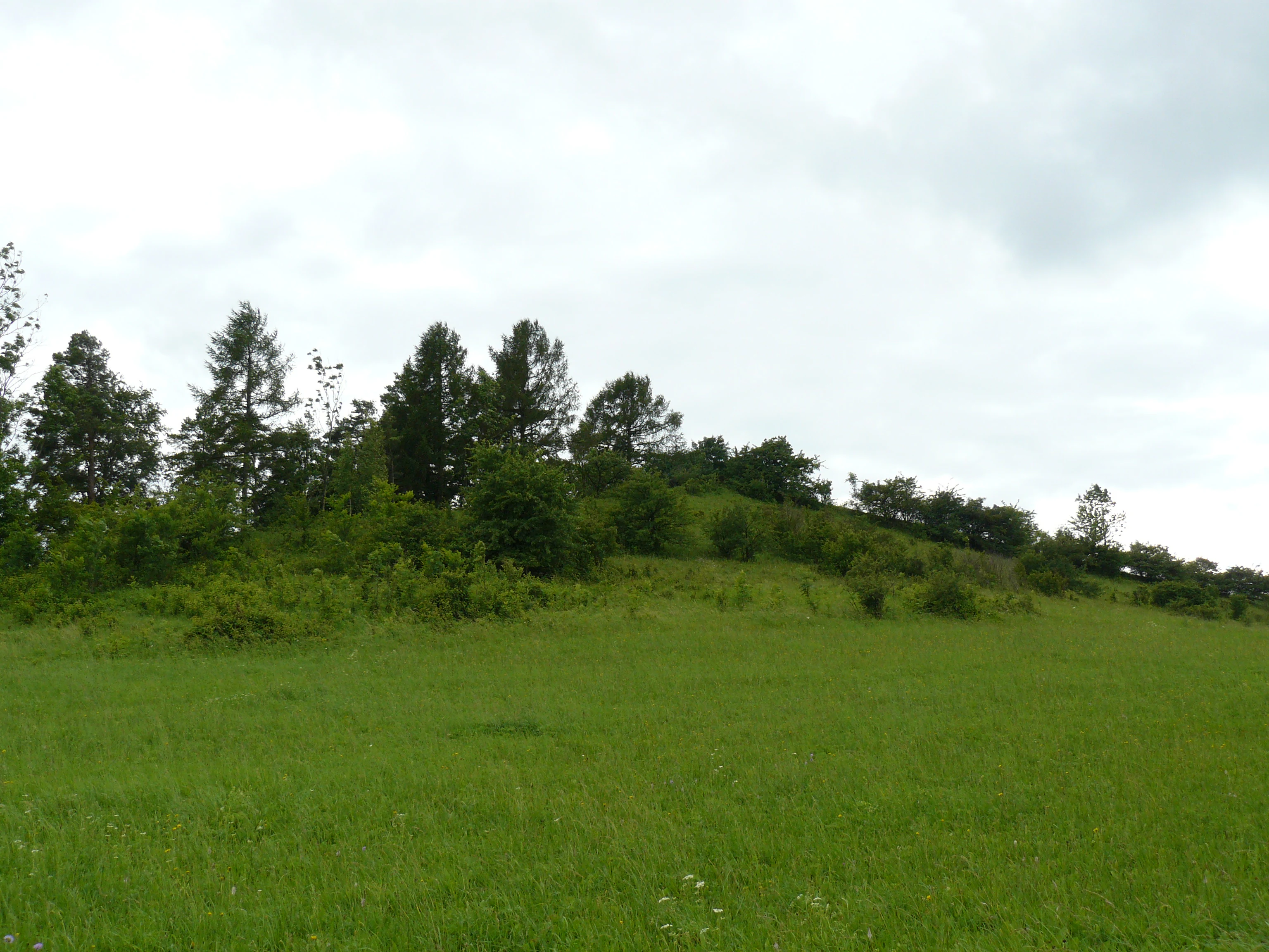
A view of a green, grassy slope with scattered trees and shrubs under a cloudy sky at the Na víně natural monument in the Czech Republic.
The rolling grassy hills and scrubby woodland of the Na víně natural monument.

Na víně history and protected-area timeline

Na víně was formally declared a natural monument on 26 September 1990 by the District National Committee in Jičín at a time when Czech conservation authorities were systematically identifying and protecting small but biologically valuable localities. The site had long been recognized for its thermophilous grassland flora growing on Cretaceous opoka, which made it a candidate for protection as part of the broader Czech network of přírodní památky (natural monuments). Management responsibility has subsequently passed to the Regional Authority of the Hradec Králové Region, which oversees the site as habitat under IUCN Category IV designation. Since its establishment, the principal concern recorded for the area has been the gradual encroachment of invasive shrubs and scrub due to the absence of regular agricultural or conservation management.

Na víně landscape and geographic character

The protected area occupies the summit and a segment of the slopes of a small hill that rises to roughly 356 meters in elevation. Geomorphologically, the hill is set within the Jičínská pahorkatina and forms part of the Klokočsko-Rovenské cuestas, specifically the Volavecká cuesta subsection of the Turnovská stupňovina. Its stepped, slope-dominated relief is characteristic of the cuesta landscape of the Bohemian Cretaceous Basin, where alternating hard and soft sedimentary layers produce pronounced ridges and gentler footslopes.

The bedrock consists of Upper Cretaceous calcareous claystones, marlstones, and opokas belonging to the Teplice Formation, locally mantled by Pleistocene loess deposits, particularly on the western side of the site. The calcium-rich mineralogy and the loess-derived soils give the slopes their distinctive dry, warm character and inform the kind of plant communities that can thrive there. Within the broader area, the hill is drained toward the Libuňka river, which shapes the regional hydrology of the Jičín Upland.

Na víně ecosystems, habitats, and plant life

The defining ecological feature of Na víně is its community of broadleaved dry grassland, a habitat type that has become increasingly rare and fragmented in the Czech countryside. The grassland develops on the calcareous opoka slopes and benefits from the warm microclimate of the sun-exposed hillsides and the high base status of the soils. These conditions sustain a species-rich assemblage of thermophilous herbs and grasses rather than closed woodland.

The botanical composition includes several species of conservation concern and characteristic dry-grassland plants. The flagship species is the wild pasqueflower (Anemone sylvestris), whose presence is one of the principal reasons for the site's protected status. It is accompanied by a suite of typical warmth-loving species such as the yellow woundwort (Stachys recta), clustered bellflower (Campanula glomerata), stemless thistle (Cirsium acaule), large speedwell (Veronica teucrium), hart's tongue (Peucedanum cervaria), Spanish salsify (Scorzonera hispanica), white helleborine (Cephalanthera damasonium), fringed gentian (Gentianopsis ciliata), and cowslip (Primula veris). The combination of orchids, gentians, and grassland forbs gives the slopes a notably rich seasonal display.

Ecologically, the site is classified as a habitat and species management area (IUCN Category IV). However, in the absence of grazing, mowing, or other active management, the open grassland is progressively being invaded by successional shrubs and woody species. This shift in vegetation structure poses the main long-term ecological threat and shapes ongoing conservation decisions for the site.

Na víně wildlife and species highlights

The wildlife information in the source material is limited primarily to the invertebrate and pollinator support associated with the site's herb-rich grassland. The dry calcareous slopes of Na víně are explicitly noted not only for rare plants but also for associated rare and endangered animal species that benefit from the open, warm habitat. Beyond this general reference, no detailed fauna inventory is provided, so further specifics about birds, mammals, or invertebrates cannot be reliably drawn from the sources.

Na víně conservation status and protection priorities

Na víně is protected as a přírodní památka (natural monument), the second-tier category of small-scale conservation areas used in the Czech system for sites of botanical, geological, or habitat importance. Under international classifications, it falls within IUCN Category IV, recognizing it as an area primarily managed to conserve particular species or habitats. Its designation reflects the recognition that broadleaved dry grasslands on calcareous substrates have become a priority for conservation across central Europe due to historical agricultural changes.

The conservation significance of the site rests on three pillars: its Cretaceous opoka geology with calcium-rich soils; its population of the wild pasqueflower and other thermophilous plants; and its role as a refuge for grassland-dependent fauna. However, abandonment of traditional land use has allowed scrub and woody species to encroach on the open slopes, gradually reducing the extent of the very grassland that the monument was designed to protect. Continued conservation effort focuses on maintaining open habitat conditions, which may include targeted management interventions to remove invasive shrubs and restore traditional disturbance regimes.

Top sights and standout views in Na víně

The standout features of Na víně are its compact but botanically rich surface of broadleaved dry grassland on a calcareous opoka hill, its population of the regionally rare wild pasqueflower, and its geological setting within the cuesta landscape of the Jičín Upland that shapes both the topography and the calcium-rich soils. The site's small scale emphasizes its quality: a tight ecological island where the interplay of geology, microclimate, and species composition is unusually concentrated for such a small area.

Best time to visit Na víně

Dry grasslands on warm slopes such as those at Na víně are typically most rewarding in late spring and early summer, when the highest diversity of thermophilous herbs and grasses is in flower and the open character of the habitat is most visible. Late summer and early autumn can offer second-bloom activity for species such as gentians and autumn-flowering composites, though later in the year the encroaching shrubs increasingly obscure the grassland structure. Because the site is a sensitive protected area, visits should be planned as low-impact, observational walks rather than as formal recreation, with timing chosen to coincide with peak botanical interest and mild, stable weather.

Monthly climate preview

Track monthly temperature ranges and precipitation patterns across the protected landscape

Na víně Climate Normals, Long-Term Temperature and Precipitation Rhythms

Historical climate data for Na víně documents measurable annual variations in temperature extremes and precipitation averages across representative coordinates. Exploring the complete monthly climate record reveals deeper insights into long-term environmental patterns and weather norms.
Annual mean8 °C
-3 °C19 °C
Jan-3°
Feb-2°
Mar
Apr
May13°
Jun17°
Jul19°
Aug18°
Sep13°
Oct
Nov
Dec-2°
Warmest month
July

18.7 °C

Coolest month
January

-3.1 °C

Wettest month
July

2.9 mm/day

Driest month
April

1.3 mm/day

Park location guide

Geography guide, regional context, and park location map for Na víně

Na víně park geography, regions, and map view in Czechia

Understand where Na víně sits in Czechia through a broader geographic reading of the surrounding landscape, nearby location context, and its mapped position within the national park landscape.

How Na víně fits into Czechia

Czech Republic is a landlocked Central European country with a population of approximately 10.9 million people. The nation was established as an independent state on January 1, 1993, following the dissolution of Czechoslovakia. Its capital and largest city is Prague, with other major urban centers including Brno, Ostrava, Plzeň, and Liberec.

Wider geography shaping Na víně in Czechia

The Czech Republic is a landlocked country in Central Europe. It is bordered by Germany to the west, Austria to the south, Poland to the northeast, and Slovakia to the southeast. The landscape is predominantly hilly, with the territory covering 78,871 square kilometers.

Map view of Na víně

Use this park location map to pinpoint Na víně in Czechia, understand its exact geographic position, and read its mapped placement within the surrounding landscape more clearly.

Pigeon | © OpenStreetMap contributors

Location context for Na víně

Královéhradecký kraj

Explore detailed imagery of dry grassland habitats and geological terrain

Na Víně Photos and Landscape Scenery: Visualizing Calcareous Slopes

Visual documentation captures the distinctive calcareous opoka slopes and rare botanical communities defining Na víně. Detailed photography reveals the unique topography and protected habitat structure across the Jičín Upland terrain.

A view of a green, grassy slope with scattered trees and shrubs under a cloudy sky at the Na víně natural monument in the Czech Republic.

Park atlas

Compare regional protected landscapes and discover adjacent dry grassland habitats.

Explore Protected Areas and Parks Near Na Víně in the Jičín Upland

Browse nearby protected natural monuments and surrounding conservation sites connected to the regional ecology of Na víně. Comparing these adjacent reserves reveals the broader distribution of calcareous grasslands across the Bohemian Cretaceous Basin.
Watercolor illustration of sandstone rock towers and coniferous trees in a landscape setting with a light color palette.
Nature reserveKrálovéhradecký kraj
About 5.6 km away#1 closest

South

Prachovské skály Nature Reserve: Geologic Atlas of Bohemian Sandstone Formations

Mapped sandstone towers and protected forest terrain in Královéhradecký kraj

Prachovské skály consists of a concentrated sandstone massif characterized by towering pinnacles and labyrinthine gorges. This nature reserve serves as a prime example of sedimentary erosion in the Bohemian Paradise region, offering a distinct landscape profile that stands in sharp contrast to the surrounding agricultural plains of the Czech Republic.

Area
2.624 km²
Established
1928
IUCN
IV
Visitors
300K annual
Watercolor painting showing a river, grassy banks, scattered trees, and distant hills
Protected landscapeCzechia
About 7.1 km away#2 closest

West

Bohemian Paradise Protected Landscape: Discover Czech Republic's Sandstone Geology and Park Boundaries

Mapped sandstone formations and historic regional geography.

Delve into Bohemian Paradise, a protected landscape in the Czech Republic celebrated for its dramatic sandstone rock formations and ancient castles. This detailed entry provides context on its unique geological character, the extent of its protected boundaries, and its significant position within the regional geography. Explore the mapped terrain and understand the atlas value of this historic protected area.

Area
181.17 km²
Established
1955
IUCN
V
Relief
Upland
A minimalist watercolor painting showing a horizontal landscape with a pond in the foreground, green fields in the midground, and soft rolling hills in the background.
Natural monumentKrálovéhradecký
About 8.5 km away#3 closest

South

Rybník Jíkavec Natural Monument: Mapping Protected Wetland Habitats in Královéhradecký

A preserved pond and meadow landscape in central Czechia

Rybník Jíkavec protects a compact cluster of wetland habitats, including open water and sedge-rich meadows within the Královéhradecký region. This nature monument highlights the ecological importance of traditionally managed fishponds and their role in maintaining rare inland marsh flora across the local Bohemian countryside.

Area
0.073 km²
Established
1998
IUCN
IV
Relief
Lowland
Natural monumentKrálovéhradecký kraj
About 9.1 km away#4 closest

West

Meziluží Natural Monument: Mapping Protected Landscape Geography in Královéhradecký Kraj

A study of sandstone terrain and historic conservation within the Bohemian Paradise

Meziluží provides a detailed look at the geography of small-scale protected sites in the Czech Republic. By analyzing its steep sandstone slopes and traditional orchard-pasture land use, users gain a clearer understanding of the complex relationship between regional geology and botanical conservation history in the Bohemian Paradise area.

Area
0.015 km²
Established
1997
Relief
Upland
Scope
Terrestrial
Natural monumentSemily District
About 11 km away#5 closest

Northwest

Vústra Natural Monument: Mapping the Protected Wetland Landscapes of the Semily District

A concentrated botanical and geological sanctuary in the Bohemian Paradise

Vústra is a highly localized natural monument in the Semily District that preserves a vital wetland complex including a pond and calcareous fen. Surrounded by characteristic sandstone rock towers and alder-spruce forests, the site serves as a vital ecological anchor within the wider Bohemian landscape. This detail page traces the specific boundaries and topographical features that define this protected monument.

Area
0.023 km²
Established
1996
IUCN
IV
Relief
Lowland
Natural monumentStředočeský kraj
About 13 km away#6 closest

West

V Dubech Natural Monument: Protected Wetland Landscapes and Geography in Czech Republic

A compact wetland mosaic in the Středočeský kraj region

V Dubech is a protected natural monument situated at the base of the Příhrazské skály sandstone formations in the Czech Republic. This site preserves a valuable wetland mosaic, including base-rich peat meadows and alder woodlands that support rare species. The park provides an essential look at the localized, water-dominated geography within the broader context of the Bohemian Paradise protected landscape.

Area
0.047 km²
Established
1998
IUCN
III
Relief
Lowland
A soft watercolor illustration of a rolling natural landscape with green trees, distant hills, and gentle colors on a white background.
Natural monumentLiberec Region
About 13 km away#7 closest

North

Na Vápenici Natural Monument: Geological Mapping and Protected Landscape Analysis

Calcareous outcrops and rare forest microhabitats in the Liberec Region

Na Vápenici represents a focused example of geological diversity, where a distinct limestone outcrop supports unique vegetation and paleontological richness. This natural monument provides a case study for understanding how isolated calcareous substrates contribute to the broader ecological health and terrain character of the Liberec Region.

Area
0.079 km²
Established
2008
IUCN
IV
Relief
Upland
Watercolor painting showing green forests, a valley, and distant mountains under a soft sky
National parkLiberec Region
About 19 km away#8 closest

Northeast

Krkonoše National Park: Central European Alpine Protected Area and Map Context

Discover glacial landforms and unique ecosystems in the Giant Mountains.

Krkonoše National Park, situated in the Liberec Region, is a premier example of a protected alpine landscape in Central Europe. This page facilitates exploration of its significant glacial geography, including distinct cirques, rockfields, and valleys, providing vital context for understanding its protected area status. Engage with the mapped terrain and discover the unique ecological features that make this national park a cornerstone of conservation and geographic study within the Czech Republic.

Area
363.52 km²
Established
1963
IUCN
II
Visitors
12.1M annual

Common questions about visiting, size, designation, and location context for Na víně

Na víně FAQs for park facts, access, geography, and protected area context

Find quick answers about Na víně, including protected-area facts, park geography, trail and visitor context, and how the park fits into its surrounding country and regional landscape.
MoriAtlas Explorer

Continue Your Protected Areas Search Across the Global Atlas

Deepen your exploration by continuing the structured search for national parks and protected areas worldwide. Utilize the comprehensive filtering capabilities to compare different conservation landscapes and refine your understanding of global park geography. Discover more about the distribution and characteristics of protected natural areas.

Global natural geography