
Mori Atlas logo
Protected landscapeNaturpark Hoher Fläming

Trace the intersection of ancient moraine ridges, deep dry valleys, and expansive lowland meadows.

Naturpark Hoher Fläming: An Expansive Protected Landscape and Glacial Geography in Brandenburg

Naturpark Hoher Fläming represents a major protected landscape in the German state of Brandenburg, defined by a dramatic contrast between high forested ridges and low-lying meadow basins. This geography features the distinctive Rummeln, a network of dry valleys cut into the ancient glacial plateaus, providing a unique look at ice-age landforms. The region preserves an intricate mosaic of woodland, agricultural fields, and historic rural heritage across more than 800 square kilometers of protected terrain.

nature parkBrandenburglow mountain ridgeancient moraine landscapeunfragmented forestwoodland and farmland mosaic
A flat-style digital illustration depicting a mountain valley featuring a central waterfall, surrounded by forest and green hills under a clear blue sky.

Naturpark Hoher Fläming

Protected landscape

Park overview

Structured park overview, official facts, and landscape profile for Naturpark Hoher Fläming

Naturpark Hoher Fläming park facts, protected area profile, and essential visitor context

Review the core facts for Naturpark Hoher Fläming, including designation, size, terrain, visitor scale, habitats, and operating context in one park-focused overview.

About Naturpark Hoher Fläming

Naturpark Hoher Fläming was formally designated in November 1997 by the Brandenburg Ministry for the Environment, making it one of the state's older large protected areas and its third-largest Großschutzgebiet. The park takes its name from the Hoher Fläming, the elevated, southern section of the broader Fläming ridge that stretches westward from Brandenburg into Saxony-Anhalt. It is operated by the state of Brandenburg through a dedicated Naturparkverwaltung housed in the restored "Alte Brennerei" at the foot of Burg Rabenstein in the village of Raben.

Geographically, the park is split into two strongly contrasting zones. In the south, the Hoher Fläming forms a hilly, heavily forested upland whose elevations date from the older Saale glaciation more than 140,000 years ago, an interval of cold conditions that left this part of Brandenburg unglaciated during the later Weichsel glaciation. The northern edge of the park plunges in steep slopes, sometimes up to 60 meters high, into the broad Baruther Urstromtal, opening into the Belziger Landschaftswiesen, a flat meadow and wetland landscape shaped by the meltwater of the much younger Weichsel glaciers.

The natural value of the park rests on the unusual combination of extensive, largely unfragmented forests, a mosaic of agricultural fields, exceptionally clean small streams, and pockets of near-natural beech woodland. Almost all of this area is protected as a Landschaftsschutzgebiet, while nine Naturschutzgebiete (nature reserves) safeguard particularly important habitats, from the Flämingbuchen beech forests and Werbiger Heide to the Belziger Landschaftswiesen and several protected stream corridors. The streams are widely considered among the cleanest in Brandenburg and harbor trout, brook lampreys, crayfish, and white-throated dippers, while the open landscapes support endangered species such as the great bustard.

Culturally, the park is anchored by a remarkable line-up of medieval castles and stone churches, alongside Renaissance-era town centers in Bad Belzig and Ziesar, a renowned English-style landscape park around Schloss Wiesenburg, and a contemporary art-trail project ("kunst land hoher fläming") that links artworks to the regional rail and walking network. Today the park blends nature conservation, sustainable regional development, cultural tourism, and barrier-free accessibility under the motto "Naturpark für alle."

Quick facts and research context for Naturpark Hoher Fläming

Naturpark Hoher Fläming lies in the southwestern part of Brandenburg, Germany, within the Potsdam-Mittelmark district and just south of the A2 motorway between Berlin and Hanover. With an area of approximately 827 square kilometers, it ranks as the third-largest Großschutzgebiet (large protected area) in Brandenburg and borders the separately designated Naturpark Fläming in Saxony-Anhalt.

The landscape is almost evenly split between woodland and agricultural land, with very limited open water but a rich network of small, ecologically valuable streams known as Flämingbäche. Almost the entire park carries landscape protection status, and within its boundaries sit nine nature reserves, including beech forests, heathlands, river valleys, and the floodplain meadows of the Belziger Landschaftswiesen. The nearby towns of Bad Belzig, Wiesenburg/Mark, and Görzke serve as key gateways to the park.

Protection and recognition

Terrestrial conservation framework established in 1997

Naturpark Hoher Fläming Protection Status and Designation History

Naturpark Hoher Fläming maintains a documented terrestrial protection status established in 1997 without imported international recognition sources. Reviewing the designated history clarifies the formal conservation framework and management scope governing the protected landscape.

Protection details

Protection scope
Terrestrial
Designated year
1997
Transboundary protection
No
Park context

Deeper park guide and search-rich context for Naturpark Hoher Fläming

Naturpark Hoher Fläming history, landscape, wildlife, and travel context

Explore Naturpark Hoher Fläming through its history, landscape character, ecosystems, wildlife, conservation priorities, cultural context, and seasonal travel timing in a structured park guide built for atlas discovery and search intent.

Why Naturpark Hoher Fläming stands out

Naturpark Hoher Fläming is best known for the unusual geological feature known as the Rummeln, a network of dry valleys that cut through the ancient, forested ridge of the Hoher Fläming. These dry valleys are both a geomorphological curiosity and a botanical refuge, supporting rare plant communities in a landscape otherwise dominated by woodland and farmland. Equally distinctive is the park's cultural layering: four medieval castles (Eisenhardt in Bad Belzig, Rabenstein, Ziesar, and Schloss Wiesenburg) along with numerous medieval Feldsteinkirchen give the protected area an unusually strong historical identity. Combined with the clean, ecologically valuable streams populated by brown trout, brook lampreys, and white-throated dippers, the park represents a rare blend of unfragmented forest, glacial geology, and living rural heritage.
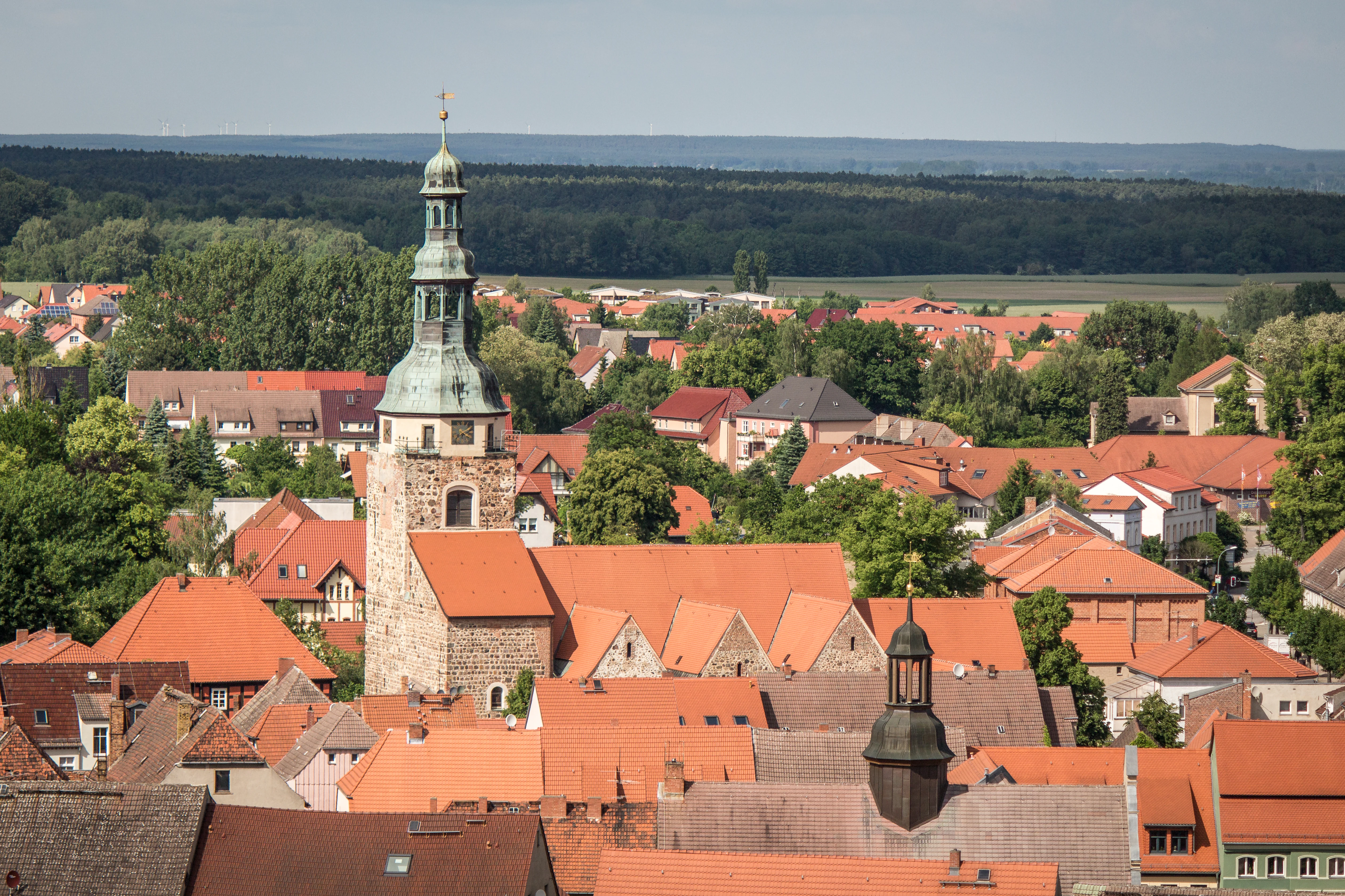
High angle view of a German town with red tiled roofs and a prominent church tower, with forested rolling hills in the background.
Panoramic view overlooking the town of Bad Belzig and the surrounding Naturpark Hoher Fläming landscape.

Naturpark Hoher Fläming history and protected-area timeline

The Hoher Fläming region carries a deep cultural past. Four medieval castles once guarded this ridge: Burg Eisenhardt in the present-day spa town of Bad Belzig, Burg Rabenstein, Burg Ziesar, and the precursor fortification of Schloss Wiesenburg. Wiesenburg's current form is a Neo-Renaissance palace, but it preserves elements of its medieval predecessor and also hosts the 123-hectare landscape park that is regarded as the most important garden monument between Potsdam and the Dessau-Wörlitz Garden Realm.

The protected area itself is comparatively recent. In 1993, civic and municipal actors created the Naturparkverein Hoher Fläming e. V. to push for formal recognition of the region. Their efforts succeeded when, on 28 November 1997, Brandenburg's environment ministry officially declared the Hoher Fläming a Naturpark. Almost simultaneously, on 17 November 1997, the larger regional landscape protection area "Hoher Fläming-Belziger Landschaftswiesen" came into force, formalizing conservation across most of the current park territory.

The information and visitor infrastructure for the new protected area was built around the historic "Alte Brennerei" in Raben, an outbuilding of Burg Rabenstein dating from around 1700 and formerly used as a horse-powered pumping station for the castle's water supply. After decades of decay following the Second World War, the building was restored by the Landkreis Potsdam-Mittelmark in 1996, and the Naturparkzentrum opened there in May 1997. Since 1991 the region has also hosted pioneering alternative-living projects, most notably the ZEGG community near Belzig and the Gut Schmerwitz initiative founded by Synanon and later continued as an organic farm.

Naturpark Hoher Fläming landscape and geographic character

The landscape of Naturpark Hoher Fläming is essentially a two-part composition of upland and lowland. In the south, the Hoher Fläming rises as a rolling plateau of forested hills and open fields, with elevations high enough to deliver sweeping views west toward the Baruther Urstromtal in the north. The hills are remnants of the older Saale glaciation, left ice-free during the later Weichsel glaciation, and they preserve a particularly mature, contiguous forested character. The entire southern portion is roughly half woodland and half agricultural land, producing a characteristic mosaic of alternating forest and field edges.

At the boundary between the two zones, the terrain drops sharply. Steep slopes, in places up to 60 meters high, descend from the forested ridge into the Baruther Urstromtal. Beyond this escarpment, the northern portion of the park opens into the Belziger Landschaftswiesen, a flat, open landscape of meadows, marshy patches, and scattered ponds. These lowland meadows were not shaped by the Saale glaciers but by the meltwater of the much more recent Weichsel glaciers, making them geologically part of the younger Jungmoränen landscape even though they sit immediately next to the much older Hoher Fläming.

A defining micro-feature of the landscape is the system of Rummeln: shallow, dry valleys etched into the surface of the Hoher Fläming. They form both a geomorphological curiosity and an ecological niche. Although the park has almost no lakes or large open waters beyond a handful of small Sölle and the ponds near Wiesenburg, it is threaded with numerous small, ecologically valuable streams that descend from the higher ground toward the northern lowlands. Long avenues of mature trees line many of the historical roads through the protected area, including the famously preserved old avenue near Klein Glien.
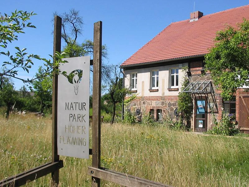
A sign on wooden posts in the foreground identifies the Naturpark Hoher Fläming, with a traditional brick and stone building visible in the background.
The nature park center in Raben, Naturpark Hoher Fläming.

Naturpark Hoher Fläming ecosystems, habitats, and plant life

Ecologically, Naturpark Hoher Fläming is a transitional landscape where ancient upland forest meets more dynamic lowland meadow and wetland. About half of the park remains under woodland cover, much of it in large, unfragmented blocks; surviving patches of near-natural beech forest with characteristic ground flora persist in places such as the Flämingbuchen reserve, recognized as a nature reserve since 1961. The other half of the park is agricultural, and the constant alternation between forest and field creates richly varied edge habitats and a continuous ecological gradient from dry upland to wet lowland.

The streams of the Fläming, especially the protected Verlorenwasserbach, Bullenberger Bach, and Planetal, are among the cleanest flowing waters in Brandenburg and rank as a key natural asset of the park. Their beds support brown trout, brook lampreys, and crayfish, while the waterside habitat provides nesting and foraging territory for white-throated dippers. The northern Belziger Landschaftswiesen, by contrast, are managed as a wet-meadow landscape, with rare plants such as the broad-leaved marsh orchid and threatened bird species such as the great bustard.

The park's territorial mosaic is reinforced by a layered system of designations that together cover essentially the entire park area. Almost the whole park is a Landschaftsschutzgebiet; on top of that sit nine Naturschutzgebiete focusing on specific high-value habitats: beech forest (Flämingbuchen, Klein Marzehns), heath (Werbiger Heide, Spring), river valleys (Bullenberger Bach, Verlorenwasserbach Oberlauf, Planetal), Rabenstein, and the Belziger Landschaftswiesen. Some of these reserves were already designated during the GDR era, giving the park a conservation heritage that predates reunification.
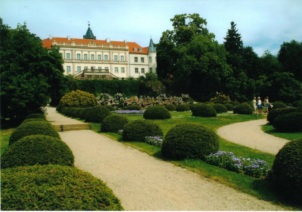
A wide view of Schloss Wiesenburg, a large historic building with a red roof, viewed from behind manicured hedges and winding gravel paths in a garden.
Schloss Wiesenburg situated within the grounds of Naturpark Hoher Fläming.

Naturpark Hoher Fläming wildlife and species highlights

The Hoher Fläming forests support healthy populations of typical central European woodland game, including fallow deer, red deer, raccoon dogs, and European mouflon. Large, unfragmented forest blocks, combined with old avenues and remnant beech stands, provide shelter and movement corridors for these species across the southern portion of the park.

The park places particular emphasis on three flagship species in its public communications: the black stork, the common noctule bat (a forest-dwelling bat species), and the middle spotted woodpecker, which the park administration has adopted as a kind of emblematic bird. The structural diversity of the woodland, with old trees and standing-dead wood, is critical for each of them.

In and along the streams of the Fläming, the aquatic and riparian fauna is unusually rich for Brandenburg. Brown trout, brook lampreys, white-throated dippers, and crayfish make their homes in the clean, gravel-bedded brooks, while the Belziger Landschaftswiesen in the north harbor rare meadow species, including breeding populations of the great bustard alongside wetland plants such as the broad-leaved marsh orchid.
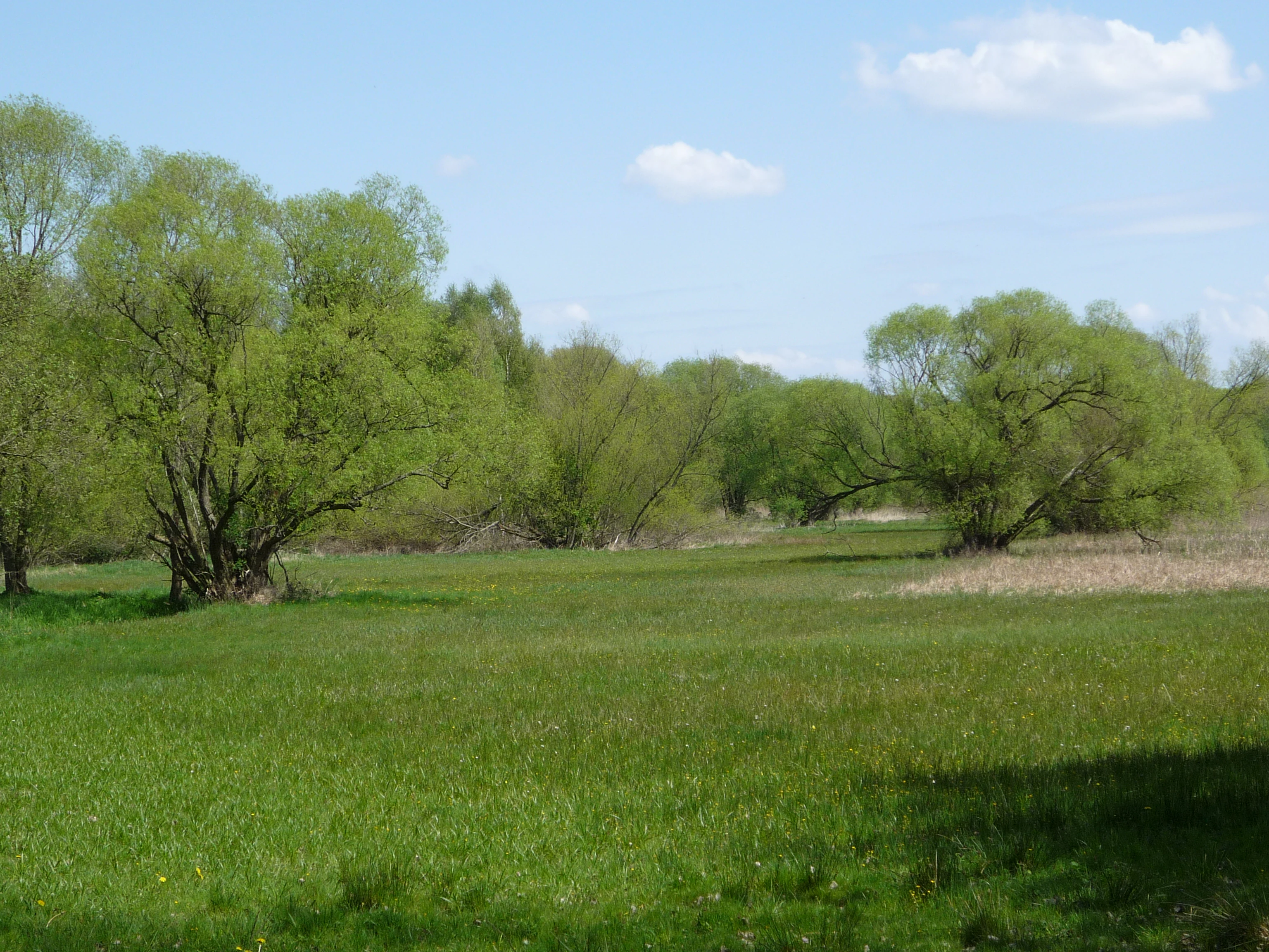
A wide view of a vibrant green meadow with scattered deciduous trees under a partially cloudy blue sky.
The green meadows of Belziger Burgwiesen in Naturpark Hoher Fläming.

Naturpark Hoher Fläming conservation status and protection priorities

Naturpark Hoher Fläming is a conservation area of regional and supraregional significance, ranking as the third-largest protected landscape in Brandenburg by area. Almost its entire 827 square kilometers are formally protected as the Landschaftsschutzgebiet "Hoher Fläming-Belziger Landschaftswiesen" under a regulation in force since 3 December 1997. Embedded within this framework are nine Naturschutzgebiete that safeguard the most sensitive habitats, ranging from beech forests and heathlands to stream valleys and floodplain meadows.

From a conservation perspective, the park's most important contributions are the protection of extensive, largely unfragmented forest on an unusually old glacial surface, the preservation of a network of exceptionally clean streams, and the maintenance of the open Belziger Landschaftswiesen as habitat for endangered meadow species such as the great bustard. The protected area also functions as a habitat network element across the broader Fläming ridge, linking with the Saxony-Anhalt Naturpark Fläming, declared in 2005.

The conservation status of the park has been a matter of active public debate. Plans for three large wind parks within or adjacent to the protected area, linked to investors such as JLW Holding AG and ABO Energy, have been widely criticized as conflicting with the regional renewable energy plan and as threatening the continuity of the forests. Local civic initiatives have campaigned to preserve the park, and a separate plan to afforest approximately 3.5 square kilometers of agricultural land is currently the largest planned conversion to forestland in Brandenburg. The Naturparkverwaltung and Naturwacht together manage species monitoring, biotope care, contract-based nature conservation with farmers, and visitor guidance to keep these multiple pressures in balance.

Naturpark Hoher Fläming cultural meaning and human context

The cultural identity of Naturpark Hoher Fläming rests on a tightly woven fabric of medieval and early modern heritage set within a deeply rural landscape. Four castles once controlled the ridge: Burg Eisenhardt (now a museum and hotel in Bad Belzig), Burg Rabenstein (now a herrgstätte hosting medieval festivals and a Christmas market), Burg Ziesar (a museum dedicated to the Christianization of the Mark Brandenburg), and Schloss Wiesenburg (a private Neo-Renaissance palace with a major historic landscape park). Bad Belzig and Ziesar are both members of the working group of historic town centers in Brandenburg, and Niemegk preserves a Renaissance-era town hall.

A second cultural strand is the region's medieval Feldsteinkirchen (fieldstone churches), small Romanesque and Gothic structures built from glacial boulders, of which many are still well preserved in villages throughout the Fläming. These stone churches are characteristic of the Fläming region as a whole, and the park's official List of Feldsteinkirchen im Fläming documents the most significant examples.

A more recent layer is the contemporary art and sustainable-living movement that has reshaped parts of the park region since the 1990s. The "kunst land hoher fläming" initiative, which began with a 2004 sculpture garden at Schloss Wiesenburg, has produced the 2.5 km Kunstspur trail and the 17 km Kunstwanderweg connecting Bad Belzig and Wiesenburg, as well as a 16 km southern route featuring artists from Flanders and the Fläming. The region also hosts the ZEGG community near Belzig, founded in 1991 on a former Stasi site, and the Bioland farm and addiction-help center at Gut Schmerwitz. Culinary heritage is part of this cultural landscape too: regional identity is tied to the potato (the "Kulinarische Kartoffeltour"), the Flämingforelle trout raised in local hatcheries, forested game and mushrooms, and the Klemmkuchen waffle cake said to have been brought to the region by Flemish settlers in the 12th and 13th centuries.
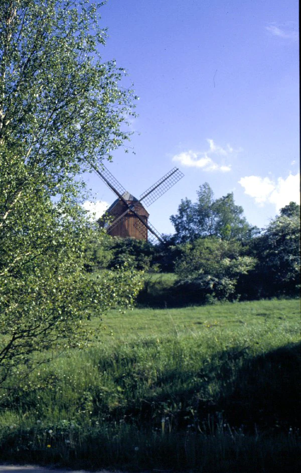
A wooden post windmill stands on a grassy hill surrounded by trees, with clear blue sky above.
Historic post mill in Borne, situated within the landscape of Naturpark Hoher Fläming.

Top sights and standout views in Naturpark Hoher Fläming

Among the park's standout features are the Rummeln, the unusual dry valleys that define the Hoher Fläming landscape, and the contrasting glacial scenery of the steep northern edge falling into the Belziger Landschaftswiesen. Equally distinctive is the line-up of four medieval castles with their associated museums, hotels, and festival traditions, supported by one of Germany's densest ensembles of medieval Feldsteinkirchen. The clean, ecologically valuable Fläming streams, the surviving beech forest patches, and the great bustard population of the northern meadows round out a conservation profile that few other Brandenburg protected areas of comparable size can match.
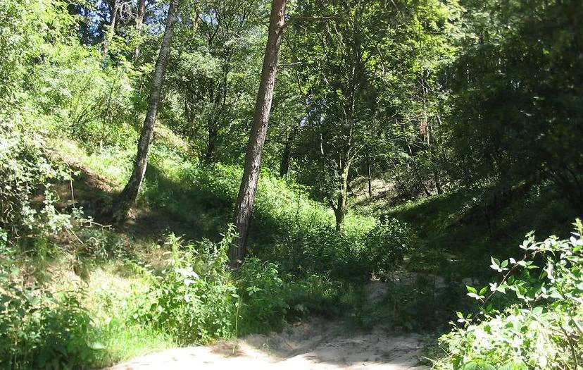
A view into the Brautrummel, a sandy dry valley gorge surrounded by lush deciduous and pine forest in a hilly region.
The Brautrummel dry valley, a characteristic geological feature within Naturpark Hoher Fläming near Grubo.

Best time to visit Naturpark Hoher Fläming

The Hoher Fläming rewards visitors differently through the year. Spring brings blossoming avenues, woodland ground flora, and popular open-air events such as the Mittelalterspektakel at Burg Rabenstein around Easter, the ceramics market in Görzke, and the Blumenmarkt in Wiesenburg. Early summer is a comfortable time for walking the Kunstwanderweg, cycling segments of the Europaradweg R1, and visiting the Wiesenburger Parkfest and Altstadtsommer events around Bad Belzig. Late summer and early autumn are widely considered the prime season for forest produce: the woodlands yield mushrooms such as chanterelles, porcini, and bay boletes, and the "48-Stunden-Fläming" regional festival in late September or early October is one of the park's signature events. Winter closes the year with traditional Christmas markets on Burg Rabenstein, in Bad Belzig, and at the Naturparkzentrum, often opened with a torch-lit procession to the castle and back.

Monthly climate preview

Long-term temperature and precipitation records measured across twelve representative months

Naturpark Hoher Fläming Climate Normals and Average Temperature Rhythms

Naturpark Hoher Fläming experiences measured monthly mean temperatures ranging from sub-zero winter readings to mid-summer maximums exceeding thirty degrees Celsius alongside stable daily precipitation. Reviewing the complete twelve-month climate profile provides detailed historical baseline data for temperature and precipitation patterns across the protected landscape.
Annual mean9 °C
0 °C20 °C
Jan
Feb
Mar
Apr
May14°
Jun18°
Jul20°
Aug20°
Sep15°
Oct
Nov
Dec
Warmest month
July

20 °C

Coolest month
January

-0.5 °C

Wettest month
July

2.4 mm/day

Driest month
April

1.1 mm/day

Park location guide

Geography guide, regional context, and park location map for Naturpark Hoher Fläming

Naturpark Hoher Fläming park geography, regions, and map view in Germany

Understand where Naturpark Hoher Fläming sits in Germany through a broader geographic reading of the surrounding landscape, nearby location context, and its mapped position within the national park landscape.

How Naturpark Hoher Fläming fits into Germany

Germany is a federal republic in Western and Central Europe with a population of over 83 million across sixteen constituent states. It is Europe's largest economy by nominal GDP and a major global exporter and importer. The capital is Berlin, and the country borders Denmark, Poland, Czech Republic, Austria, Switzerland, France, Luxembourg, Belgium, and the Netherlands.

Wider geography shaping Naturpark Hoher Fläming in Germany

Germany is located in Western and Central Europe, spanning 357,022 km². It borders Denmark to the north, Poland and the Czech Republic to the east, Austria and Switzerland to the south, and France, Luxembourg, Belgium, and the Netherlands to the west. The country has coastlines on the Baltic Sea and North Sea to the north, with the Alps located in the southern region.

Map view of Naturpark Hoher Fläming

Use this park location map to pinpoint Naturpark Hoher Fläming in Germany, understand its exact geographic position, and read its mapped placement within the surrounding landscape more clearly.

Pigeon | © OpenStreetMap contributors

Location context for Naturpark Hoher Fläming

Brandenburg

Visual reference for forested ridges, dry valleys, and glacial lowlands

Naturpark Hoher Fläming Landscape Photos and Protected Area Scenery

Explore detailed imagery of Naturpark Hoher Fläming to understand its unique upland terrain and glacial valley formations. Visual documentation reveals the distinct habitats, escarpments, and landscape character defining this protected German region.

High angle view of a German town with red tiled roofs and a prominent church tower, with forested rolling hills in the background.

A dirt path flanked by large, green leafy trees forming an avenue, leading into the distance with a wooden fence on the left and yellow fields on the right.

A sign on wooden posts in the foreground identifies the Naturpark Hoher Fläming, with a traditional brick and stone building visible in the background.

A wide view of Schloss Wiesenburg, a large historic building with a red roof, viewed from behind manicured hedges and winding gravel paths in a garden.

A wide view of a vibrant green meadow with scattered deciduous trees under a partially cloudy blue sky.

Two large geometric wooden cube sculptures partially integrated around pine trees in a forest.

A wooden post windmill stands on a grassy hill surrounded by trees, with clear blue sky above.

A view into the Brautrummel, a sandy dry valley gorge surrounded by lush deciduous and pine forest in a hilly region.

Park atlas

Discover adjacent protected landscapes and surrounding regional park geography.

Other Parks Near Naturpark Hoher Fläming for Regional Protected Area Comparison

Compare Naturpark Hoher Fläming with other nearby protected areas across the surrounding central German region. Broaden your geographic exploration by examining adjacent forest reserves, glacial uplands, and river valley landscapes.
Nature reserveBrandenburg
About 18 km away#1 closest

North

Belziger Landschaftswiesen Nature Reserve: Protected Wetland Geography and Glacial Valley Mapping

Regional landscape profile, peatland ecology, and glacial valley terrain

Spanning over 7,000 hectares in the Baruther Urstromtal, the Belziger Landschaftswiesen serves as a vital nature reserve and lowland habitat in Brandenburg. This geography-focused profile traces the wetland's identity as a through-flow peatland, its role in hosting rare meadow birds, and the defining physical edges where the flat valley floor meets the high Fläming ridge.

Area
45 km²
Established
2005
Relief
Lowland
Climate
Temperate
A watercolor illustration showing a landscape with small clusters of trees and grassy ground under a soft, light-filled sky.
Nature reserveBrandenburg
About 28 km away#2 closest

Northeast

Lehniner Mittelheide und Quellgebiet der Emster: Nature Reserve and Protected Landscape Atlas

Mapping Brandenburg inland heath and spring valley terrain

Examine the geographic layout of Lehniner Mittelheide und Quellgebiet der Emster, a nature reserve in the Brandenburg district of Potsdam-Mittelmark. This protected area connects dry sandy heathland with the aquatic corridors of the Emster headwaters and Mühlenteich pond, offering a clear example of glacial lowland landscape integration.

Area
6.4 km²
Established
1996
IUCN
IV
Relief
Lowland
A wide watercolor illustration depicting a calm river bordered by green grasses and shrubs, with soft pink and grey hills in the background.
Protected areaBrandenburg
About 34 km away#3 closest

Northwest

Vogelschutzgebiet Fiener Bruch: Regional Geography and Protected Wetland Landscapes

A critical Natura 2000 sanctuary in the Brandenburg glacial valley.

The Vogelschutzgebiet Fiener Bruch functions as a large-scale wetland mosaic within the Glogau-Baruth Urstromtal, characterized by flat meadows and drainage channels. This protected area supports an intensive conservation landscape for great bustards and various waterbird populations, serving as an essential component of the regional natural geography in eastern Germany.

Area
100.05 km²
Established
1979
Relief
Lowland
Climate
Temperate
A soft watercolor illustration of a gentle river winding through green meadows and low hills under a hazy, warm sky.
Nature reserveBrandenburg
About 36 km away#4 closest

East

Europäisches Vogelschutzgebiet Nuthe-Nieplitz-Niederung Protected Area in Brandenburg

Glacial lake and river floodplain landscape context

This significant nature reserve forms a major ecological hub south of Berlin, characterized by its interplay of river floodplains, shallow glacial lakes, and open meadows. It is a critical site for breeding and migratory birds, offering a unique look at the hydrological systems and lowland geography that define the rural character of Brandenburg.

Area
61.44 km²
Established
2007
Relief
Lowland
Climate
Temperate
A panoramic watercolor illustration showing a meadow with green grasses, pink and purple wildflowers, shrubs, a misty water body, rolling green hills in the background, and a bird flying in a pale yellow sky
Protected landscapeBrandenburg
About 36 km away#5 closest

East

Naturpark Nuthe-Nieplitz: Geographic Overview of a Brandenburg Protected Landscape

Glacial river valleys and rewilded pine forest terrain

Naturpark Nuthe-Nieplitz represents a significant protected area in Brandenburg, Germany, characterized by its interconnected river lowlands and glacial features. The terrain features a rich mix of reed-fringed lakes, alder woodlands, and former military grounds currently undergoing ecological restoration. This overview traces the boundaries and landscape character of the park, providing essential context for its role in regional conservation.

Area
623.23 km²
Established
1999
Relief
Lowland
Climate
Temperate
A soft watercolor illustration showing rolling green hills, a small stream winding through the foreground, and distant purple-toned peaks against a white background.
Nature reserveBrandenburg
About 39 km away#6 closest

Northeast

Glindower Alpen: Protected Nature Reserve and Clay Mining Geography in Brandenburg

A striking post-industrial landscape and nature reserve

Glindower Alpen is a 120-hectare nature reserve near Werder, Germany, characterized by an atypical terrain of deep ravines and ridges resulting from historical clay mining. This protected area stands out as an island of mixed deciduous forests and dry grasslands amidst the broader flat geography of the Brandenburg region.

Area
1.19 km²
Established
1995
Relief
Upland
Climate
Temperate
Nature reserveRhineland-Palatinate
About 41 km away#7 closest

East

Bärluch Nature Reserve: Protected Wetland Terrain and Regional Geography in Brandenburg

Post-glacial fens and swamp forest mosaic

Bärluch represents an essential protected nature reserve in Germany, defined by its bowl-shaped post-glacial depressions and diverse wetland habitats. The area preserves a rare ecological mosaic of oak-dominated forests, wet grasslands, and swampy lowland basins that provide vital breeding grounds for disturbance-sensitive bird populations and specialized regional wildlife.

Area
1.6 km²
Established
2000
Relief
Lowland
Climate
Temperate
Watercolor painting of a lush, flat landscape with low green hills in the distance and wetland vegetation in the foreground.
Protected landscapeBrandenburg
About 43 km away#8 closest

North

Landschaftsschutzgebiet Brandenburger Osthavelniederung: Protected Landscape and Regional Geography

Mapped Havel River floodplain and glacial moraine terrain in Brandenburg.

Covering over 9,000 hectares, this protected landscape serves as a prime example of the Brandenburg Havel region. The area integrates a network of canals, dikes, and backwater lakes with isolated moraine ridges, creating a diverse geographic mosaic of river-managed lowlands and forested glacial remnants.

Area
93.81 km²
Established
1998
Relief
Lowland
Climate
Temperate

Common questions about visiting, size, designation, and location context for Naturpark Hoher Fläming

Naturpark Hoher Fläming FAQs for park facts, access, geography, and protected area context

Find quick answers about Naturpark Hoher Fläming, including protected-area facts, park geography, trail and visitor context, and how the park fits into its surrounding country and regional landscape.
MoriAtlas Explorer

Continue Your Protected Areas Search Across the Global Atlas

Deepen your exploration by continuing the structured search for national parks and protected areas worldwide. Utilize the comprehensive filtering capabilities to compare different conservation landscapes and refine your understanding of global park geography. Discover more about the distribution and characteristics of protected natural areas.

Global natural geography