
Mori Atlas logo
Protected landscapeNaturpark Mecklenburgische Schweiz und Kummerower See

A mosaic of glacial lake basins, winding river valleys, and historical estate woodlands

Naturpark Mecklenburgische Schweiz und Kummerower See Protected Landscape and Regional Geography

Naturpark Mecklenburgische Schweiz und Kummerower See serves as a major protected region in Mecklenburg-Vorpommern, where the Peene river valley and three large glacial lakes define the terrain. This landscape integrates centuries-old oak stands, diverse wetland habitats, and agricultural plains. The area functions as a vital corridor for migratory waterfowl while preserving a unique cultural history marked by manor houses and historical estate parks.

nature parkglacial lakesriver valleyPeene rivermigratory waterfowlmanor houses
A flat vector-style illustration of a lake landscape with green and orange bushes in the foreground, yellow grasses, and a calm body of water reaching toward distant rolling hills under a soft sky.

Naturpark Mecklenburgische Schweiz und Kummerower See

Protected landscape

Park overview

Structured park overview, official facts, and landscape profile for Naturpark Mecklenburgische Schweiz und Kummerower See

Naturpark Mecklenburgische Schweiz und Kummerower See park facts, protected area profile, and essential visitor context

Review the core facts for Naturpark Mecklenburgische Schweiz und Kummerower See, including designation, size, terrain, visitor scale, habitats, and operating context in one park-focused overview.

About Naturpark Mecklenburgische Schweiz und Kummerower See

Naturpark Mecklenburgische Schweiz und Kummerower See lies in the central-northern part of Mecklenburg-Vorpommern, in a region that carries the informal name of "Mecklenburg Switzerland" because of its rolling, richly varied terrain. The park covers around 673 square kilometers and was formally established in 1997 as one of several nature parks in the state. It sits north of the much larger Mecklenburgische Seenplatte and bridges an area between the lake district around Güstrow and Waren and the lower-lying landscapes toward Demmin and the Peene.

Geographically, the park is organized around water. Three significant lakes anchor its identity: Malchiner See, Kummerower See, and Teterower See. The Peene, the largest river within the park, threads through the area and connects many of these features, creating a transition zone between open water, marshy floodplain, and cultivated ground. The interplay between wide lake surfaces, gentle river meanders, forested ridges, and open fields gives the region a layered, scenic quality that is rare in this part of northern Germany.

About 19 percent of the park is forested, while roughly another 10 percent consists of lakes and rivers. The remaining area is shaped by centuries of human use, expressed not only in farmland and meadows but also in the dense concentration of manor houses, castles, and Gutsparks, the landscaped parks of former noble estates. These estates, along with stands of old oak trees, contribute strongly to the park's identity and reinforce the impression of a working, lived-in cultural landscape rather than a purely wild one.

Ecologically, the park is notable as a staging and resting area for migratory waterfowl, particularly northern duck species that use the lakes and river wetlands during their seasonal movements. The combination of large open water bodies, sheltered bays, and wet meadows makes it attractive for these species and has helped secure its conservation status. Within the park, nine nature reserves overlap with its territory, including the large Peenetal reserve between Salem and Jarmen and several smaller sites protecting forests, moors, and moraine features.

The park is also a cultural landscape, with its estates, castles, and historical parks forming an important part of what draws visitors and explains the area's heritage. The park administration is seated in Basedow, a village closely associated with one of the region's prominent estates. Access is straightforward for travelers in the region: the A 19 motorway via the Krakow am See and Güstrow exits, and the A 20 via the Tessin and Bad Sülze exits, all connect to the surrounding areas of the park.

Quick facts and research context for Naturpark Mecklenburgische Schweiz und Kummerower See

Naturpark Mecklenburgische Schweiz und Kummerower See was formally designated in 1997 and covers an area of about 673 km², making it one of the larger nature parks in Mecklenburg-Vorpommern. Its territory stretches across the Mecklenburgische Seenplatte and Rostock districts and includes the towns of Dargun, Demmin, Teterow, Malchin, and Waren (Müritz) on its perimeter.

Forests make up roughly 19 percent of the park, while lakes and rivers account for about 10 percent, with the rest shaped by cultural countryside. The park is anchored by three large lakes: Malchiner See, Kummerower See, and Teterower See, and is drained primarily by the Peene, its principal river. Several nature reserves fall entirely or partly within the park, with the extensive Peenetal reserve being the largest. The park administration is based in Basedow.

Protection and recognition

Explore documented terrestrial protection scope and international recognition sources.

Naturpark Mecklenburgische Schweiz und Kummerower See Protection Status

Naturpark Mecklenburgische Schweiz und Kummerower See maintains a documented terrestrial protection scope within regional conservation frameworks. Official records aggregate available designation details, management boundaries, and international recognition sources for structured analysis.

Protection details

Protection scope
Terrestrial
Transboundary protection
No
Park context

Deeper park guide and search-rich context for Naturpark Mecklenburgische Schweiz und Kummerower See

Naturpark Mecklenburgische Schweiz und Kummerower See history, landscape, wildlife, and travel context

Explore Naturpark Mecklenburgische Schweiz und Kummerower See through its history, landscape character, ecosystems, wildlife, conservation priorities, cultural context, and seasonal travel timing in a structured park guide built for atlas discovery and search intent.

Why Naturpark Mecklenburgische Schweiz und Kummerower See stands out

The park is best known for the combination of broad glacial lakes and the winding Peene river landscape, which together create a distinctive mosaic of water, woodland, and agricultural land in northeastern Germany. It is also recognized for its centuries-old oaks, its dense network of manor houses and castles with associated historical parks, and its significance as a stopover for northern duck species during migration. These features together give the park an unusually rich blend of natural and cultural landscape qualities.
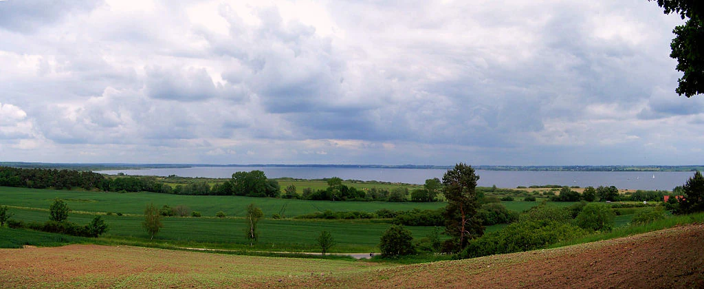
Panoramic landscape view of a large lake in the distance, framed by green meadows, cultivated fields, and trees under a cloudy sky.
A wide view over the rolling fields and forests surrounding Kummerower See.

Naturpark Mecklenburgische Schweiz und Kummerower See history and protected-area timeline

The Naturpark Mecklenburgische Schweiz und Kummerower See was formally established in 1997 through a state ordinance, becoming one of the designated nature parks of Mecklenburg-Vorpommern. The underlying landscape, however, had been shaped long before that designation, by glacial processes that created the lakes and moraines, and by centuries of agriculture, estate development, and forest management that produced the cultural landscape visible today.

The estate structures, manor houses, and landscaped parks that are now a defining feature of the area reflect the long aristocratic and landowning traditions of Mecklenburg. Old oak stands and park woodlands associated with these estates speak to centuries of continuity in the management of the land. The formal protection of the area as a Naturpark in the late twentieth century brought these older patterns of landscape use into a structured framework of conservation, recreation, and regional identity.

Naturpark Mecklenburgische Schweiz und Kummerower See landscape and geographic character

The landscape of the park is a classic example of the young moraine scenery of northern Germany, shaped by the last glaciation and then smoothed and modified by centuries of human use. The terrain is gently rolling rather than mountainous, with a pattern of low ridges, hollows, and basins that hold the area's lakes and wetlands.

Three large lakes dominate the visible geography: Malchiner See, Kummerower See, and Teterower See. These are broad, shallow lakes typical of the region, bordered by mixed forests, meadows, reed beds, and small settlements. Beyond them, the Peene river and its tributaries carve soft, meandering valleys through the terrain, producing a very different atmosphere of slow-moving water, marshland, and floodplain woodland.

Forests are a consistent companion to this water-led scenery. Woodlands, including old oak stands associated with historical estates, frame many of the lakes and river reaches. Between these natural elements, the cultural landscape of fields, pasture, villages, and estate parks fills out the remainder of the view, giving the park a layered quality in which water, woodland, and farmland are all closely interwoven.
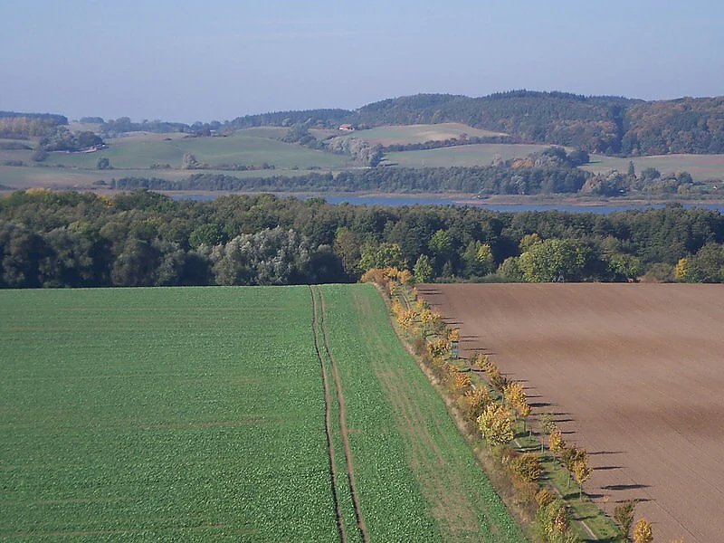
An elevated, wide-angle view of a rolling rural landscape showing a green field on the left and a tilled brown field on the right, separated by a line of trees. In the distance, a lake stretches across the horizon, bordered by forested hills under a hazy sky.
A view across agricultural fields and forests toward Malchiner See in Naturpark Mecklenburgische Schweiz und Kummerower See.

Naturpark Mecklenburgische Schweiz und Kummerower See ecosystems, habitats, and plant life

Ecologically, the park is best understood as a transition zone between the lake district to its south and the river and coastal lowlands to its north. The combination of large open lakes, sheltered bays, river meanders, wet meadows, and patches of deciduous forest creates a mosaic of habitats that supports a diverse community of plants and animals, and especially a rich community of water-associated species.

Forests cover around nineteen percent of the park and include both managed woodland and older, structurally richer stands, some associated with long-established estate parks and notable for their centuries-old oaks. Lakes and rivers account for roughly ten percent of the surface area and provide the most distinctive ecological element, while the remainder of the park is cultural landscape of fields, meadows, and settlements.

The protected status of the area is reinforced by a network of nature reserves, including the extensive Peenetal reserve between Salem and Jarmen, the Gruber Forst, the Teterower Heidberge, and several smaller reserves protecting moors, moraines, and lakeshore features. Together these reserves protect specific elements of the park's biodiversity that complement the broader landscape-level protection of the Naturpark itself.

Naturpark Mecklenburgische Schweiz und Kummerower See wildlife and species highlights

The park is most closely associated with waterfowl, and it has a recognized role as a resting area for migratory ducks that breed further north. The combination of large, open lake surfaces, sheltered bays, reed-fringed shores, and the slow-moving Peene river valley creates ideal conditions for these seasonal visitors to feed and rest during their migrations.

Beyond waterfowl, the lakes, rivers, and forests of the park support a broader community of wetland, woodland, and farmland-associated species typical of the northeastern German countryside. Wet meadows and floodplain sections along the Peene, along with the reed zones of Malchiner See, Kummerower See, and Teterower See, are particularly important for marshland and aquatic wildlife.

Naturpark Mecklenburgische Schweiz und Kummerower See conservation status and protection priorities

From a conservation perspective, the park is significant because it protects not only a single landscape type but a layered combination of glacially formed lakes, river wetlands, old-growth oaks, and historical cultural landscape elements. This layered character, together with its role as a stopover for migratory waterfowl, gives it ecological value that extends beyond the region itself.

Protection operates on two levels. The broader Naturpark designation, established in 1997, frames the area as a landscape-level protection zone focused on sustainable use, biodiversity, and recreation. Within this frame, nine nature reserves add targeted protection to specific sites, including the large Peenetal between Salem and Jarmen, parts of the Gruber Forst, the Teterower Heidberge, the Barschmoor, the Hellgrund, the Stauchmoräne north of Remplin, the Binsenbrink in the Teterower See, the Wüste und Glase reserve, and the Kalk-Zwischenmoor Wendischhagen. These reserves focus on habitats such as river floodplains, forests, moors, and moraine features that are less common in the surrounding agricultural landscape.

Naturpark Mecklenburgische Schweiz und Kummerower See cultural meaning and human context

The cultural character of the park is inseparable from its physical landscape. Mecklenburg has long been dominated by large estates, and the Naturpark contains a remarkable concentration of manor houses, castles, and Gutsparks, the landscaped parks once attached to noble and large landowning estates. These buildings and their parklands shape the visual identity of the region as much as its lakes and forests do.

Old estate-associated oak stands, village churches, and smaller rural settlements add further historical depth. The combination of these estate landscapes with the glacial lakes and Peene river valley has produced a regional identity that the Naturpark explicitly seeks to preserve, framing the area not just as a natural reserve but as a long-inhabited cultural landscape.

Top sights and standout views in Naturpark Mecklenburgische Schweiz und Kummerower See

The park's most distinctive qualities lie in its combination of three large lakes and the deeply meandering Peene river, framed by forests that include centuries-old oaks. This natural setting is closely entwined with a dense network of manor houses, castles, and historical estate parks that define much of the region's visual and cultural character.

Its role as a stopover for migratory ducks, and the strong network of nature reserves, especially the large Peenetal reserve, give it lasting ecological significance. Together, these features make the park a place where glacial landscape, waterfowl habitat, and historical countryside meet.

Best time to visit Naturpark Mecklenburgische Schweiz und Kummerower See

The park's character shifts gently with the seasons, and several periods stand out for different reasons. Spring is when waterfowl movement peaks in the lakes and along the Peene, and when deciduous woodland and estate parks come into fresh leaf, making the cultural landscape feel particularly alive.

Summer brings warm, long days suited to lake and river scenery, with stable conditions for exploring the estates and the broader countryside. Autumn adds strong color to the deciduous forests, including the old oak stands, and brings renewed migratory bird activity. Winter offers quieter conditions, frozen or near-frozen lake edges, and an atmospheric view of the estates and villages, though services across the park are typically reduced outside the main seasons.

Monthly climate preview

Long-term temperature and precipitation patterns sampled from representative park coordinates

Naturpark Mecklenburgische Schweiz und Kummerower See Annual Climate Normals

Naturpark Mecklenburgische Schweiz und Kummerower See exhibits a measured annual cycle of monthly temperature variations alongside recorded precipitation patterns from 1991 to 2020. Reviewing the complete twelve-month climatology profile provides deeper insight into long-term environmental averages across the protected area.
Annual mean9 °C
0 °C18 °C
Jan
Feb
Mar
Apr
May12°
Jun16°
Jul18°
Aug18°
Sep14°
Oct
Nov
Dec
Warmest month
July

18.1 °C

Coolest month
January

-0.1 °C

Wettest month
July

2.4 mm/day

Driest month
April

1.3 mm/day

Park location guide

Geography guide, regional context, and park location map for Naturpark Mecklenburgische Schweiz und Kummerower See

Naturpark Mecklenburgische Schweiz und Kummerower See park geography, regions, and map view in Germany

Understand where Naturpark Mecklenburgische Schweiz und Kummerower See sits in Germany through a broader geographic reading of the surrounding landscape, nearby location context, and its mapped position within the national park landscape.

How Naturpark Mecklenburgische Schweiz und Kummerower See fits into Germany

Germany is a federal republic in Western and Central Europe with a population of over 83 million across sixteen constituent states. It is Europe's largest economy by nominal GDP and a major global exporter and importer. The capital is Berlin, and the country borders Denmark, Poland, Czech Republic, Austria, Switzerland, France, Luxembourg, Belgium, and the Netherlands.

Wider geography shaping Naturpark Mecklenburgische Schweiz und Kummerower See in Germany

Germany is located in Western and Central Europe, spanning 357,022 km². It borders Denmark to the north, Poland and the Czech Republic to the east, Austria and Switzerland to the south, and France, Luxembourg, Belgium, and the Netherlands to the west. The country has coastlines on the Baltic Sea and North Sea to the north, with the Alps located in the southern region.

Map view of Naturpark Mecklenburgische Schweiz und Kummerower See

Use this park location map to pinpoint Naturpark Mecklenburgische Schweiz und Kummerower See in Germany, understand its exact geographic position, and read its mapped placement within the surrounding landscape more clearly.

Pigeon | © OpenStreetMap contributors

Location context for Naturpark Mecklenburgische Schweiz und Kummerower See

Mecklenburg-Vorpommern

Visualizing glacial lakes, river valleys, and protected nature park scenery

Naturpark Mecklenburgische Schweiz und Kummerower See Photos and Landscapes

Visual documentation captures glacial lakes, winding river valleys, and old forest stands across Naturpark Mecklenburgische Schweiz und Kummerower See. Examining protected area imagery reveals terrain patterns and habitat features that define the regional landscape character.

Panoramic landscape view of a large lake in the distance, framed by green meadows, cultivated fields, and trees under a cloudy sky.

A wide, calm lake surrounded by low-lying hills and reedy marshes under a clear, bright blue sky.

An elevated, wide-angle view of a rolling rural landscape showing a green field on the left and a tilled brown field on the right, separated by a line of trees. In the distance, a lake stretches across the horizon, bordered by forested hills under a hazy sky.

Park atlas

Compare regional protected areas and connected glacial lake landscapes

Parks Near Naturpark Mecklenburgische Schweiz und Kummerower See

Browse protected areas and wetland reserves located near Naturpark Mecklenburgische Schweiz und Kummerower See to compare regional glacial lake geography. Evaluating adjacent natural terrain helps establish broader ecological context across the wider northeastern German lake district.
Watercolor painting of a landscape with a lake, trees, and distant hills
National parkMecklenburg-Vorpommern
About 31 km away#1 closest

South

Müritz National Park: Explore Protected Beech Forests and Glacial Lakelands in Mecklenburg-Vorpommern

Germany's largest national park: mapped boundaries and terrain.

Müritz National Park represents a significant protected landscape within northeastern Germany's Mecklenburg-Vorpommern region. Its expansive territory encompasses not only Germany's largest lake, Müritz, but also substantial tracts of ancient beech forests awarded UNESCO World Heritage status. Users can explore the park's glacial terrain, its intricate network of lakes and wetlands, and understand its position within the regional geography, making it a key destination for structured atlas-based discovery of German protected areas.

Area
318 km²
Established
1990
IUCN
II
Relief
Lowland
Protected landscapeMecklenburg-Vorpommern
About 40 km away#2 closest

Southwest

Naturpark Nossentiner/Schwinzer Heide: Geographic Atlas of an Inland Protected Landscape

Glacial Sanders and Lake Ecosystems in Mecklenburg-Vorpommern

This protected landscape features extensive pine-covered outwash plains and diverse kettle lakes shaped by glacial meltwater. Spanning the Mecklenburg-Vorpommern region, the park provides an essential study in inland natural geography, ranging from its unique sandy forest clearings to the protected moorland habitats that shelter bird populations.

Area
355 km²
Established
1990
Relief
Lowland
Scope
Terrestrial
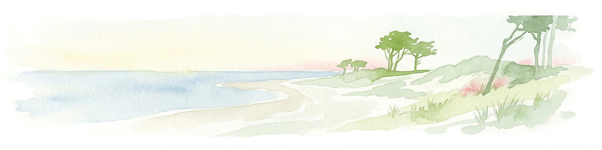
Watercolor illustration showing a coastal lagoon with sandy shoreline, calm water, sand dunes, and sparse vegetation including trees and grasses
National parkMecklenburg-Vorpommern
About 65 km away#3 closest

North

Western Pomerania Lagoon Area National Park: Detailed Geographic and Protected Landscape Context

Explore its mapped boundaries and unique Baltic Sea coastal geography.

Western Pomerania Lagoon Area National Park is a vital protected landscape in Mecklenburg-Vorpommern, renowned for its complex network of peninsulas, islands, and extremely shallow brackish 'bodden' waters. This page serves as an atlas entry, detailing the park's geographic features, its distinctive wind-driven water level fluctuations, and its ecological importance as a major migratory bird staging area. Users can investigate the mapped extent of this significant German national park and understand its unique place within the regional geography.

Area
805 km²
Established
1990
IUCN
II
Relief
Lowland
Watercolor illustration of a winding river surrounded by soft green trees and low hills under a pale sky.
Nature reserveBrandenburg
About 68 km away#4 closest

Southeast

Kastavenseen-Molkenkammersee Protected Nature Reserve: Mapped Lake Geography and Forest Terrain

A key node in the Brandenburg lake and forest conservation network

Kastavenseen-Molkenkammersee is a notable nature reserve in Brandenburg defined by its four core waterbodies. The area features a complex mosaic of wetlands, reedbeds, and mixed woodland typical of the post-glacial lake districts. As a protected landscape, it serves as an essential link in the ecological corridor between the Uckermark and the neighboring Mecklenburg borderlands.

Area
2.68 km²
Established
2009
IUCN
IV
Nature reserveBrandenburg
About 73 km away#5 closest

Southwest

Dömnitz Nature Reserve: Geographic Atlas and Protected Landscape Overview in Brandenburg

Riparian corridor mapping and lowland habitat preservation

The Dömnitz Nature Reserve, located in Brandenburg, protects 160 hectares of diverse riparian and forest habitat along a tributary of the Stepenitz. This atlas entry provides geographic data on the reserve, tracing its function as a managed wetland corridor and its place within the broader network of nature reserves defining the Prignitz countryside.

Area
1.6 km²
Established
2018
IUCN
IV
Relief
Lowland
Nature reserveBrandenburg
About 79 km away#6 closest

Southeast

Zerweliner Koppel Nature Reserve: Mapped Protected Landscapes in the Brandenburg Region

A preserved mosaic of woodland and lakeside habitats

Located in the Uckermark district, Zerweliner Koppel represents a vital protected area characterized by its interweaving of wet and dry habitats. This nature reserve supports an array of ecosystems ranging from nutrient-poor lakes and calcareous fens to oak and beech forests, providing a stable refuge for diverse wildlife species in northeastern Germany.

Area
1.93 km²
Established
2005
IUCN
IV
Relief
Lowland
Nature reserveBrandenburg
About 85 km away#7 closest

Southeast

Kleine Schorfheide Nature Reserve: Brandenburg Protected Area and Landscape Atlas

Mapped terrain, river floodplains, and forest mosaic in Northern Brandenburg

Spanning over 73 square kilometres, Kleine Schorfheide stands as a significant nature reserve in Brandenburg. It protects a vast, contiguous mosaic of open former military training lands, the natural Havel river floodplain, and the Himmelpforter Heide forest, creating a distinct regional landscape defined by its varied terrain and interconnected lake systems.

Area
73.75 km²
Established
1994
IUCN
IV
Watercolor painting of a coastal landscape with green grass in the foreground, a line of trees in the midground, and a soft pink horizon in the distance.
Protected landscapeMecklenburg-Vorpommern
About 89 km away#8 closest

East

Naturpark Insel Usedom: Geography and Protected Landscape Atlas

Coastal cliffs, lagoon systems, and diverse forest terrain in Mecklenburg-Vorpommern

Naturpark Insel Usedom encompasses the German side of Usedom Island, offering a condensed landscape that bridges the Baltic Sea with inland brackish lagoons. This protected area integrates sandy shorelines, steep moraine cliffs, and varied wetland habitats, making it an essential subject for understanding the ecological and geographic character of northeastern Germany.

Area
632 km²
Established
1999
Relief
Lowland
Climate
Temperate

Common questions about visiting, size, designation, and location context for Naturpark Mecklenburgische Schweiz und Kummerower See

Naturpark Mecklenburgische Schweiz und Kummerower See FAQs for park facts, access, geography, and protected area context

Find quick answers about Naturpark Mecklenburgische Schweiz und Kummerower See, including protected-area facts, park geography, trail and visitor context, and how the park fits into its surrounding country and regional landscape.
MoriAtlas Explorer

Continue Your Protected Areas Search Across the Global Atlas

Deepen your exploration by continuing the structured search for national parks and protected areas worldwide. Utilize the comprehensive filtering capabilities to compare different conservation landscapes and refine your understanding of global park geography. Discover more about the distribution and characteristics of protected natural areas.

Global natural geography