
Mori Atlas logo
Nature reserveNaturschutzgebiet Diemelsee

Analyzing the ecological mosaic and shoreline boundaries of this Waldeck-Frankenberg wetland

Naturschutzgebiet Diemelsee Nature Reserve: Mapped Protected Landscapes and Geographic Context

Naturschutzgebiet Diemelsee represents a compact but ecologically rich nature reserve located in the Waldeck-Frankenberg district of northern Hesse, Germany. This protected area focuses on the dynamic transition zone where the Itter stream meets the reservoir, creating an essential refuge for specialized wetland plants and water-associated birdlife. The landscape is defined by seasonal water level fluctuations that expose mudflats and pioneer vegetation, providing a vital case study in the interaction between managed reservoir environments and indigenous river-mouth ecosystems.

wetlandreservoir marginbird sanctuarypioneer vegetationreed bedswillow scrub
Vector-style illustration of a valley with a winding river, evergreen forest, and gentle hills under a soft, hazy sky.

Naturschutzgebiet Diemelsee

Nature reserve

Park overview

Structured park overview, official facts, and landscape profile for Naturschutzgebiet Diemelsee

Naturschutzgebiet Diemelsee park facts, protected area profile, and essential visitor context

Review the core facts for Naturschutzgebiet Diemelsee, including designation, size, terrain, visitor scale, habitats, and operating context in one park-focused overview.

About Naturschutzgebiet Diemelsee

Naturschutzgebiet Diemelsee is a small yet distinctive nature reserve located at the western tip of the western arm of the Diemelsee reservoir, in the Hessian part of the Waldeck-Frankenberg district. Although the surrounding Diemelsee is a substantial artificial lake in the foothills of the Rothaargebirge and the eastern Sauerland, the reserve itself is a focused wetland area of about 18.7 hectares where the Itter river enters the lake. This setting gives the protected area a very different character from the wooded uplands and open water of the broader reservoir landscape, concentrating ecological value in a narrow band of shoreline, inlet, and stream corridor.

The reserve was first protected in 1965, specifically because of its importance to birds, and was re-designated in 1982, a common pattern in Germany where nature reserves are periodically reaffirmed under updated legal frameworks. Its location within the Naturpark Diemelsee places it inside a larger landscape of recreation, low mountain forest, and reservoir scenery, but the reserve itself is managed primarily for its ecological functions rather than visitor use. The northern boundary is marked by the L 393 state road, while the shoreline of the lake and the lower course of the Itter form its ecological core.

Because water levels in the reservoir vary substantially through the year, the reserve experiences recurring cycles of inundation and exposure. During summer drawdowns, freshly uncovered sediments emerge along the shore, allowing pioneer plant communities to colonize the bare ground. Over time, these open zones transition back into reed, willow scrub, and swamp-like woodland nearer the Itter. This constant reshaping of habitats is central to the reserve's character and to its continued importance for the birdlife that it was originally protected to safeguard.

Quick facts and research context for Naturschutzgebiet Diemelsee

The Naturschutzgebiet Diemelsee covers around 18.7 hectares and lies within the municipality of Diemelsee in the Waldeck-Frankenberg district of Hesse, Germany. It sits at the western end of the western arm of the Diemelsee reservoir, where the Itter river enters the lake. It was first designated as a nature reserve in 1965 for its significance to birds, then re-designated in 1982. The protected area is enclosed within the larger Naturpark Diemelsee and is bordered to the north by the L 393 state road.

Protection and recognition

Documented terrestrial protection metrics and official designation data

Naturschutzgebiet Diemelsee Protection Status and Conservation Scope

Terrestrial protection status for Naturschutzgebiet Diemelsee outlines the documented management scope and conservation boundaries for the reserve. Official designation records provide structured oversight details for evaluating regional environmental governance frameworks.

Protection details

Protection scope
Terrestrial
Transboundary protection
No
Park context

Deeper park guide and search-rich context for Naturschutzgebiet Diemelsee

Naturschutzgebiet Diemelsee history, landscape, wildlife, and travel context

Explore Naturschutzgebiet Diemelsee through its history, landscape character, ecosystems, wildlife, conservation priorities, cultural context, and seasonal travel timing in a structured park guide built for atlas discovery and search intent.

Why Naturschutzgebiet Diemelsee stands out

Naturschutzgebiet Diemelsee is best known for its value as a bird habitat along the fluctuating shoreline of the Diemelsee reservoir, particularly where the Itter stream meets the lake. The reserve is recognized for the seasonal drawdown zones where pioneer plant communities develop on freshly exposed mudflats, alongside dense reed and willow growth in the wetter margins. These short-lived but ecologically rich transitions between open water, muddy shore, and shrubby wetland make it a notable small refuge for water-associated birdlife and specialized wetland plants in the Waldeck-Frankenberg region.
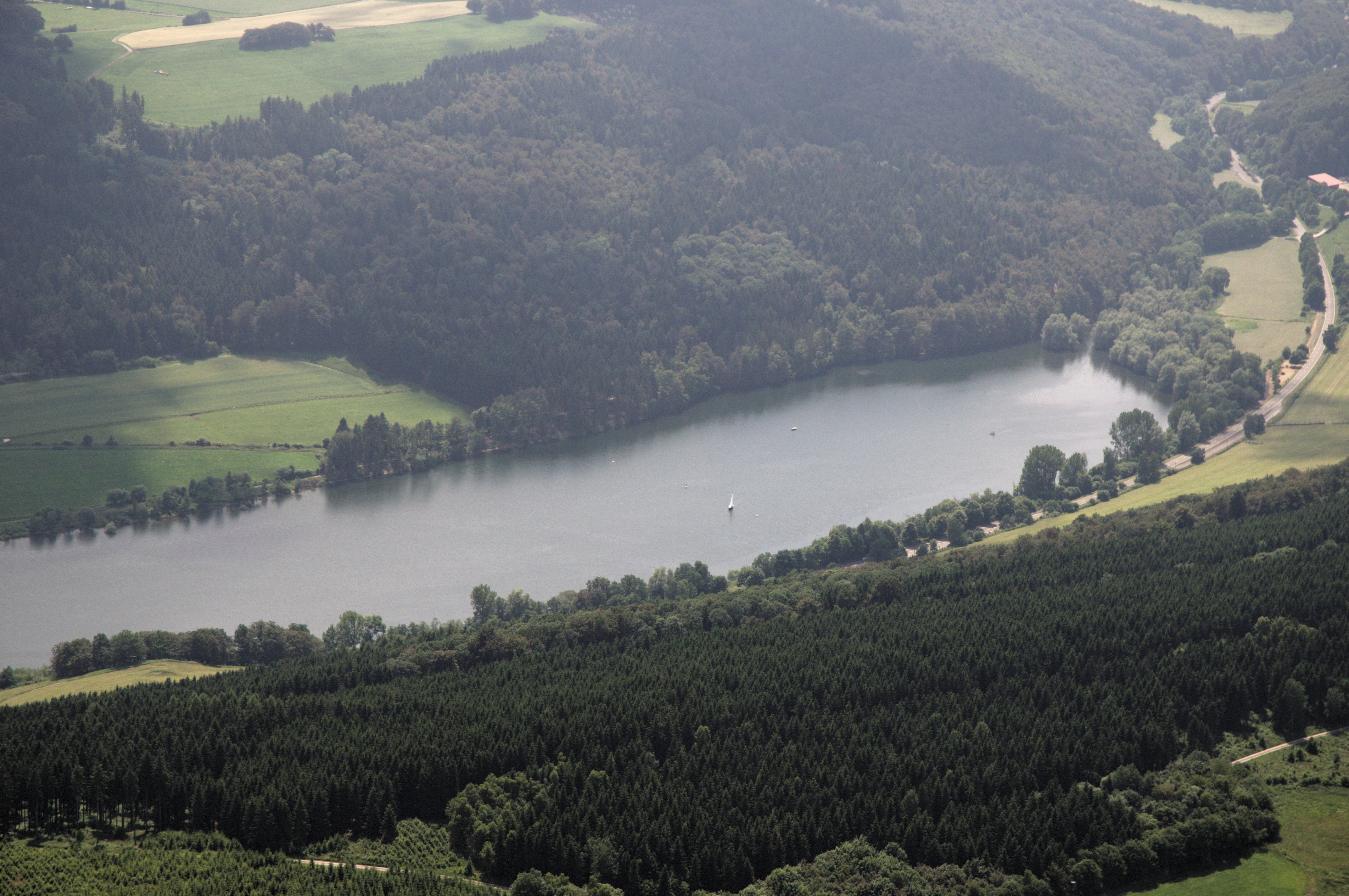
Aerial perspective of a calm lake surrounded by dense forests, meadows, and a winding road in the Sauerland countryside.
Aerial view of the Diemelsee reservoir and surrounding nature reserve in the Sauerland region.

Naturschutzgebiet Diemelsee history and protected-area timeline

Naturschutzgebiet Diemelsee was first designated in 1965, with its protection explicitly grounded in the importance of the area for birds. In the German nature conservation framework of that period, such designations typically recognized habitat value based on the rarity, special character, and beauty of an area. The reserve was re-designated in 1982, reaffirming and updating its protected status under evolving conservation law and consolidating its role as a recognized site for waterbird and wetland habitat within the Waldeck-Frankenberg district.

The reserve sits within the larger Naturpark Diemelsee, a broader landscape designation that frames the reservoir and its surroundings as a region for both nature protection and low-key recreation. The history of the protected area is therefore closely tied to the man-made character of the lake itself: the Diemelsee reservoir was created by damming the Diemel river, and the wildlife interest of the reserve has grown from the dynamic ecological edge that resulted at the confluence with the Itter stream. The repeated designation of the reserve reflects an evolving recognition that reservoir margins can, over time, develop into valuable secondary habitats for wetland species.

Naturschutzgebiet Diemelsee landscape and geographic character

The landscape of Naturschutzgebiet Diemelsee is defined by the meeting of water and shore at the westernmost end of the western arm of the Diemelsee reservoir. Although the reserve's name evokes the broader lake, only about a quarter of its actual area is open water; the remainder consists of shoreline, exposed lake bed, and the lower reaches of the Itter stream. The terrain is generally flat to gently sloping, shaped by the reservoir's operational water levels rather than by dramatic relief.

The most visually distinctive landscape feature is the seasonal drawdown zone. When the water level of the Diemelsee drops in summer, wide stretches of bare, freshly exposed sediment appear along the shore. These create a soft, open character of mudflats and shallow margins that contrasts with the deeper, more stable reservoir water further out. As the season progresses, this zone becomes a transition landscape between open water, muddy banks, and increasingly vegetated shoreline.

Along the Itter itself the character shifts again, with denser, more structured vegetation framing the slow-moving stream as it approaches the lake. The overall impression is one of a small but layered wetland margin, where the geometric lines of a managed reservoir give way to a more irregular mosaic of water, mud, reed, and shrubby growth.

Naturschutzgebiet Diemelsee ecosystems, habitats, and plant life

Ecologically, Naturschutzgebiet Diemelsee is best understood as a reservoir-edge wetland complex, shaped by the seasonal rhythm of the Diemelsee water levels. The most distinctive ecological feature is the pioneer vegetation that colonizes the drawdown zone each summer. As water recedes, exposed sediments are occupied by so-called pioneer communities adapted to unstable, nutrient-rich, often muddy substrates, including mudflat-style pioneer floras and two-tooth (Bidens-type) communities that thrive in freshly disturbed wet ground.

Closer to the stable waterline, reed sweet-grass (Phalaris arundinacea) stands form denser reed fringes, interspersed with thick willow scrub that stabilizes the shore and provides cover along the transition to terrestrial vegetation. Along the Itter, sections of the stream corridor develop a more wooded character with alder-dominated, swamp-forest-like structures, where periodically saturated soils support moisture-loving tree species and a more shaded, structurally complex habitat.

This shifting mosaic of open mud, annual pioneer plants, emergent reeds, willow thickets, and wet woodland is the core of the reserve's ecological identity. It is essentially a small-scale example of how reservoir margins in central German low mountain landscapes can develop into ecologically dynamic zones, distinct from both the open water of the lake and the surrounding forested uplands of the Naturpark Diemelsee.

Naturschutzgebiet Diemelsee wildlife and species highlights

Wildlife interest in Naturschutzgebiet Diemelsee centers on birds, which were the explicit reason for the reserve's original designation in 1965. The combination of open water, seasonal mudflats, reed beds, willow scrub, and wet woodland along the Itter provides a varied suite of habitats that can support water-associated species throughout the year.

The open water of the reservoir hosts waterbirds typical of larger Hessian low-mountain lakes, including various duck species, while the seasonally exposed muddy shores offer attractive feeding conditions for waders and other shore birds during summer drawdown. Reed fringes and willow thickets provide nesting cover and refuge from disturbance, and the wet woodland along the Itter adds a further habitat layer for species associated with damp, structurally rich forest edges.

Beyond birds, the quieter margins of the Itter also support mammals adapted to wetland environments. The reserve is known in particular for the presence of the European beaver (Castor fiber) along the Itter, an indicator of the ecological recovery of waterways in the region. Although the reserve is small, the diversity of its habitats within a compact area gives it an outsized value for wildlife observation in the Waldeck-Frankenberg district.

Naturschutzgebiet Diemelsee conservation status and protection priorities

From a conservation perspective, Naturschutzgebiet Diemelsee is significant as a small but well-defined example of how a man-made reservoir margin can develop into valuable wildlife habitat. Its original 1965 designation specifically highlighted the site's importance for birds, and its re-designation in 1982 reaffirmed that value under updated conservation law. The combination of rarity, special character, and scenic quality recognized in the original protection order is consistent with the broader criteria used for German nature reserves at that time.

The reserve's conservation value lies particularly in its dynamic character. Because the water levels of the Diemelsee fluctuate significantly through the year, the shoreline is constantly re-shaped, producing a mosaic of pioneer habitats that would be absent on a more stable lake edge. This natural disturbance regime keeps habitat conditions favorable for specialist plants and birds that depend on freshly exposed sediment and early-successional wetland vegetation.

Embedded within the larger Naturpark Diemelsee, the reserve also contributes to a wider landscape-scale conservation picture in northern Hesse and eastern North Rhine-Westphalia, linking reservoir-edge habitat with broader patterns of low mountain forest, stream valley, and protected landscape. Even at less than 20 hectares, its focused protection of a particular habitat type makes it a meaningful element of the regional network of Naturschutzgebiete in the Waldeck-Frankenberg district.

Top sights and standout views in Naturschutzgebiet Diemelsee

Among the standout features of Naturschutzgebiet Diemelsee are its dynamic drawdown zones, where annually exposed sediments support distinctive pioneer plant communities such as mudflat floras and two-tooth associations. Equally notable is the dense fringe of reed sweet-grass stands and willow scrub that stabilizes the shoreline, and the swamp-forest-like stretches of woodland that frame the lower Itter as it flows into the reservoir. The reserve also offers one of the clearest local examples of how a regulated reservoir can, through careful habitat protection, become a refuge for waterbirds and other wetland-associated wildlife, including the beaver along the Itter.

Best time to visit Naturschutzgebiet Diemelsee

The character of Naturschutzgebiet Diemelsee shifts meaningfully through the year, in step with the reservoir's water levels. Late summer is typically the most distinctive period to experience the reserve, when falling water levels expose wide muddy and sediment-rich shorelines, allowing pioneer vegetation to develop and attracting birds drawn to freshly opened feeding grounds. Spring and early summer, by contrast, tend to show higher water levels and a more uniform shoreline of reed and willow, with quieter but still ecologically rich conditions. Autumn and winter bring their own character as water levels fluctuate again and waterbird presence changes seasonally, though weather and access conditions in the surrounding Sauerland foothills can be more challenging outside the warmer months.

Monthly climate preview

Long-term representative point measurements tracking annual temperature and precipitation rhythms

Naturschutzgebiet Diemelsee Climate Normals and Monthly Weather Data

Representative coordinate records show average temperatures ranging from sub-zero winter minimums to peak summer maximums alongside consistent monthly precipitation distributions. Accessing the complete monthly profile provides detailed historical baseline data for temperature and precipitation patterns across the protected terrain.
Annual mean9 °C
0 °C18 °C
Jan
Feb
Mar
Apr
May12°
Jun15°
Jul18°
Aug18°
Sep14°
Oct
Nov
Dec
Warmest month
July

18 °C

Coolest month
January

-0.2 °C

Wettest month
July

2.6 mm/day

Driest month
April

1.7 mm/day

Park location guide

Geography guide, regional context, and park location map for Naturschutzgebiet Diemelsee

Naturschutzgebiet Diemelsee park geography, regions, and map view in Germany

Understand where Naturschutzgebiet Diemelsee sits in Germany through a broader geographic reading of the surrounding landscape, nearby location context, and its mapped position within the national park landscape.

How Naturschutzgebiet Diemelsee fits into Germany

Germany is a federal republic in Western and Central Europe with a population of over 83 million across sixteen constituent states. It is Europe's largest economy by nominal GDP and a major global exporter and importer. The capital is Berlin, and the country borders Denmark, Poland, Czech Republic, Austria, Switzerland, France, Luxembourg, Belgium, and the Netherlands.

Wider geography shaping Naturschutzgebiet Diemelsee in Germany

Germany is located in Western and Central Europe, spanning 357,022 km². It borders Denmark to the north, Poland and the Czech Republic to the east, Austria and Switzerland to the south, and France, Luxembourg, Belgium, and the Netherlands to the west. The country has coastlines on the Baltic Sea and North Sea to the north, with the Alps located in the southern region.

Map view of Naturschutzgebiet Diemelsee

Use this park location map to pinpoint Naturschutzgebiet Diemelsee in Germany, understand its exact geographic position, and read its mapped placement within the surrounding landscape more clearly.

Pigeon | © OpenStreetMap contributors

Location context for Naturschutzgebiet Diemelsee

Waldeck-Frankenberg

Visual reference guide to the seasonal mudflats, reed beds, and wetland habitats of Naturschutzgebiet Diemelsee.

Naturschutzgebiet Diemelsee Landscape Photos and Protected Area Scenery

Examine detailed photographs documenting the fluctuating water levels, shoreline vegetation, and river mouths that define the protected landscape of Naturschutzgebiet Diemelsee. Visual documentation reveals the ecological transitions between open reservoir waters and dense willow thickets across the reserve.

Aerial perspective of a calm lake surrounded by dense forests, meadows, and a winding road in the Sauerland countryside.

A brown beaver sitting on the riverbank amid fallen branches and sticks, grooming itself near the water edge.

Park atlas

Compare surrounding regional geography and connected wetland habitats

Explore Other Parks Near Naturschutzgebiet Diemelsee And Protected Landscapes

Visitors exploring Naturschutzgebiet Diemelsee can browse other protected areas within the surrounding region to compare regional park geography. Examining adjacent wetland reserves and low mountain terrain provides broader context for local conservation networks.
A watercolor painting showing a soft, peaceful landscape with a small body of water in the foreground, surrounded by grassy banks and low hills in the distance.
Nature reserveHochsauerlandkreis
About 4.4 km away#1 closest

Northwest

Naturschutzgebiet Schwarzes Haupt: A Protected Limestone Landscape in Hochsauerlandkreis

Mapped calcareous grasslands and orchid-rich beech forests.

This nature reserve covers 9.8 hectares of the Schwarze Haupt hill, featuring a layered terrain of rocky outcrops, former quarry remnants, and rare grassland habitats. It serves as a critical site for regional biodiversity, linking calcareous ecosystems within the eastern Sauerland through its specialized beech forests and limestone cliff formations.

Area
0.098 km²
Established
2008
Relief
Upland
Scope
Terrestrial
A wide watercolor-style illustration of a soft landscape featuring rolling green hills, scattered forest patches, and pale pink mountains in the background with a light sky.
Nature reserveNorth Rhine-Westphalia
About 4.9 km away#2 closest

North

Hollenloch Nature Reserve: Karst Cave Systems and Protected Limestone Woodland Geography

Exploration of subterranean geology and regional karst habitats

Hollenloch stands as one of the longest and deepest cave systems within the Sauerland, developed inside dense Upper Devonian reef limestone. This protected site integrates surface karst features like the Schwalgloch with specialized forest ecosystems, providing a vital subterranean refuge for diverse bat species and a rich record of prehistoric human activity.

Area
0.032 km²
Established
2001
Relief
Upland
Climate
Temperate
A soft watercolor illustration of a landscape featuring layered green hills, a distant forest silhouette, and pale sky, rendered in a light, minimalist style.
Nature reserveHochsauerlandkreis
About 5.3 km away#3 closest

Northeast

Naturschutzgebiet Oberes Diemeltal: Protected Floodplain and River Geography in Hochsauerlandkreis

Mapped riparian landscapes and riverine conservation corridors

Naturschutzgebiet Oberes Diemeltal preserves an undeveloped section of the upper Diemel river valley. The landscape is defined by its branching river network, wet meadows, and rare floodplain vegetation, offering a clear window into the riverine geography of the eastern Sauerland region in Germany.

Area
1.87 km²
Established
2001
Scope
Terrestrial
Water
Major water bodies
A wide, pale watercolor illustration showing rolling green and yellow hills with scattered trees.
Nature reserveHochsauerlandkreis
About 6.7 km away#4 closest

Northwest

Naturschutzgebiet Scheffelberg / Kalberstert: Mapped Limestone Hill Landscape

Nature reserve located within the Hochsauerlandkreis regional geography

Analyze the topographic features of the Naturschutzgebiet Scheffelberg / Kalberstert, including its conical rock outcrops and expansive dry grasslands. This protected area offers a clear look at the limestone hill systems defining this part of Hochsauerlandkreis, highlighting the intersection of beech woodland and open rocky terrain through detailed geographic mapping.

Area
0.456 km²
Established
2008
Relief
Upland
Climate
Temperate
A watercolor landscape illustration showing soft, rolling green hills, coniferous trees, and a hazy background.
Nature reserveHochsauerlandkreis
About 7 km away#5 closest

Northeast

Naturschutzgebiet Padberg: A Protected Landscape in the Hochsauerlandkreis Region

Diabas geology and forest habitat mapping

Naturschutzgebiet Padberg protects a compact but ecologically rich landscape of beech forests and craggy rock cliffs. Its position above the Diemel valley highlights the relationship between volcanic Diabas topography and woodland development within the Hochsauerlandkreis district.

Area
0.467 km²
Established
2001
Relief
Upland
Climate
Temperate
Nature reserveHessen
About 7.2 km away#6 closest

East

Naturschutzgebiet Am Mühlenberg bei Adorf: Protected Forest and Volcanic Terrain

Geographic overview of a key Hessen nature reserve

Spanning 33 hectares in northern Hessen, Naturschutzgebiet Am Mühlenberg bei Adorf is defined by its Devonian volcanic bedrock and varied microclimates. The reserve provides a detailed look at how aspect and slope create contrasting forest communities, from dry oak stands to cool-air ravine woodland, offering a concentrated study in protected-area botanical richness.

Area
0.335 km²
Established
1992
IUCN
IV
Relief
Upland
Nature reserveNorth Rhine-Westphalia
About 8.2 km away#7 closest

West

Naturschutzgebiet Poppenberg: A Detailed Geographic Overview of this Nature Reserve

Exploring Limestone Cliff Habitats and Regional Forest Ecosystems

Naturschutzgebiet Poppenberg represents an essential ecological link within the Brilon limestone hill network. This nature reserve offers a concentrated study in geology and ecology, showcasing exposed rock formations, historical mining traces, and a diverse range of woodland habitats compressed into a compact, protected area within North Rhine-Westphalia.

Area
0.007 km²
Established
2008
Relief
Upland
Climate
Temperate
A watercolor landscape illustration showing a winding river flowing through a green meadow with a line of trees in the background.
Nature reserveNorth Rhine-Westphalia
About 8.2 km away#8 closest

Southwest

Naturschutzgebiet Oberes Hoppecketal: Geography and Protected Valley Landscapes

A vital river floodplain reserve in eastern Sauerland

Naturschutzgebiet Oberes Hoppecketal protects 21.4 hectares of near-natural river channel and valley floor near Brilon. This reserve represents a crucial link in the regional mosaic of floodplain habitats, offering important data on aquatic connectivity and wet meadow ecosystems within the North Rhine-Westphalia conservation landscape.

Area
0.214 km²
Established
2001
Relief
Lowland
Climate
Temperate

Common questions about visiting, size, designation, and location context for Naturschutzgebiet Diemelsee

Naturschutzgebiet Diemelsee FAQs for park facts, access, geography, and protected area context

Find quick answers about Naturschutzgebiet Diemelsee, including protected-area facts, park geography, trail and visitor context, and how the park fits into its surrounding country and regional landscape.
MoriAtlas Explorer

Continue Your Protected Areas Search Across the Global Atlas

Deepen your exploration by continuing the structured search for national parks and protected areas worldwide. Utilize the comprehensive filtering capabilities to compare different conservation landscapes and refine your understanding of global park geography. Discover more about the distribution and characteristics of protected natural areas.

Global natural geography