

Mori Atlas logo
Nature reserveNaturwald Krackentännig

A secluded nature reserve in the Steigerwaldvorland shaped by moist valley terrain and stream hydrology

Naturwald Krackentännig: Mapping the Protected Ash and Alder Forests of Lower Franconia

Naturwald Krackentännig serves as a vital protected landscape within the Kitzingen district near Prichsenstadt. This nature reserve, characterized by its rare dominance of European ash and black alder, represents a significant shift in Bavarian forest policy aimed at preserving undisturbed woodland. The terrain is defined by the shallow valley of the Gänsseegraben stream, creating a distinct moist habitat that contrasts with the surrounding drier plateaus of the Steigerwald foothills.

natural forestNaturwaldash and alder forestbroadleaved woodlandlowland forestSteigerwaldvorland

Naturwald Krackentännig

Nature reserve

Park overview

Structured park overview, official facts, and landscape profile for Naturwald Krackentännig

Naturwald Krackentännig park facts, protected area profile, and essential visitor context

Review the core facts for Naturwald Krackentännig, including designation, size, terrain, visitor scale, habitats, and operating context in one park-focused overview.

About Naturwald Krackentännig

Naturwald Krackentännig is a small but ecologically distinctive natural forest in the northern Bavarian region of Lower Franconia. Although it covers only about 2.63 hectares, it has been formally withdrawn from forestry use and placed under the protection of the Bavarian Forest Act, allowing its trees, soil, and associated wildlife to develop without further human intervention. The reserve forms part of a broader network of Naturwaldflächen that the Bavarian government has progressively designated across the state forest.

The site is located within the Steigerwaldvorland, the transitional landscape between the Main River valley and the higher, forested Steigerwald hills to the east. This area is characterized by gently rolling terrain, mixed farmland, and small patches of woodland intersected by narrow stream valleys. Within this patchwork, the Krackentännig forest stands out because of its unusually wet, low-lying character, which has favored a tree community rarely seen in the otherwise drier, oak- and beech-dominated forests of the region.

The Bayerische Staatsforsten, which owns and manages the surrounding forest, highlights the stand as a rare example of a forest dominated by European ash and black alder. These species typically occur alongside other moisture-loving broadleaves such as willow and birch, and they form a habitat type that supports a distinctive set of amphibians, insects, fungi, and ground flora that differ from those of the surrounding plateau woods.

Although the reserve is small, its designation reflects a broader shift in Bavarian forest policy. Following the success of the Volksbegehren Artenvielfalt und Naturschönheit, a citizens' initiative on biodiversity and natural beauty in Bavaria in 2019, the state government committed to setting aside roughly ten percent of the state forest from active management. Krackentännig was part of that wave of designations, having first been taken out of timber harvesting as a Class 1 forest before being formally converted into a Naturwald in 2022.

Quick facts and research context for Naturwald Krackentännig

Naturwald Krackentännig lies in the Steigerwaldvorland, the gently undulating foothill landscape that lies in front of the Steigerwald uplands in Lower Franconia, a region of Bavaria in southern Germany. The reserve is administratively part of the city of Prichsenstadt, between the localities of Neudorf to the west and Breitbach to the east, within the district of Kitzingen.

It was designated in 2022 under Article 12a of the Bavarian Forest Act, which governs Naturwaldreservate and Naturwaldflächen, and is administered by the Bayerische Staatsforsten, the Bavarian state forestry enterprise. Its identifier is NW-4620, and the official protected area covers approximately 2.63 hectares. The site's defining ecological feature is its rare deciduous stand of ash and black alder along a small stream valley.

Protection and recognition

Examine documented conservation parameters and international recognition records for Naturwald Krackentännig.

Naturwald Krackentännig Protection Status and Designated Terrestrial Scope

Naturwald Krackentännig maintains a documented terrestrial protection scope without imported international recognition sources or assigned transboundary status. Structured records outline the verified conservation parameters, designation history, and management scope associated with this protected area.

Protection details

Protection scope
Terrestrial
Transboundary protection
No
Park context

Deeper park guide and search-rich context for Naturwald Krackentännig

Naturwald Krackentännig history, landscape, wildlife, and travel context

Explore Naturwald Krackentännig through its history, landscape character, ecosystems, wildlife, conservation priorities, cultural context, and seasonal travel timing in a structured park guide built for atlas discovery and search intent.

Why Naturwald Krackentännig stands out

Krackentännig is best known for being one of the very few protected forest stands in the Steigerwald foothills dominated jointly by European ash and black alder, two tree species that typically thrive in moist, nutrient-rich valley soils rather than on the dry plateau and slope forests that dominate the surrounding region. Because ash and alder woodland communities of this kind are increasingly rare in central European forests, partly due to ash dieback and long-term drainage of valley landscapes, the site's value lies less in its size than in the unusual composition and undisturbed development of its old, structurally diverse trees. It is also a notable local example of how Bavarian forest policy, in response to the 2019 species diversity citizens' initiative, has translated into specific small-area set-asides on state forest land.
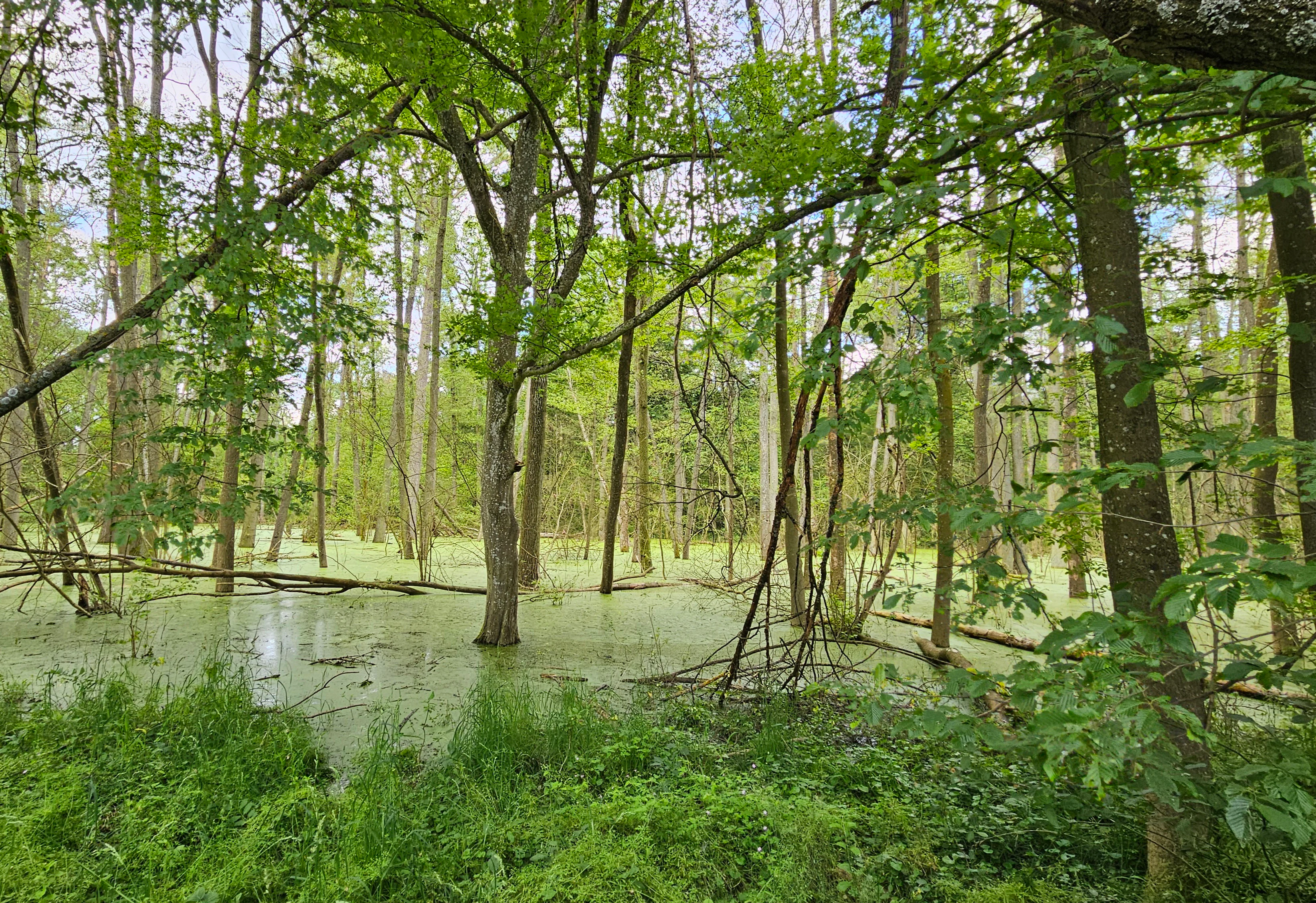
Naturwald Krackentännig view
A view of Naturwald Krackentännig, a forest reserve in Bavaria

Naturwald Krackentännig history and protected-area timeline

The wider Krackentännig forest belonged for a long time to the working forest estate of the Bayerische Staatsforsten, the Bavarian state forestry enterprise that manages most of Bavaria's state-owned woodland. For most of its modern history, the area was therefore part of an actively managed timber forest, even though its species composition set it apart from the surrounding oak and beech woods.

A turning point came in 2019, when the Bavarian citizens' initiative known as the Volksbegehren Artenvielfalt und Naturschönheit in Bayern gathered sufficient signatures to compel political follow-up. In response, the Bavarian state government committed to setting roughly ten percent of the state forest permanently aside from active timber use. Important protection measures for species and habitats were also added to Bavarian nature conservation law through this process.

Within that context, the Bayerische Staatsforsten first removed the Krackentännig site from regular harvesting as a so-called Klasse-1-Wald, a category of forest withheld from timber use to support ecological values. In 2022, the area was then formally re-designated as a Naturwald under Article 12a of the Bavarian Forest Act, which governs Naturwaldreservate and Naturwaldflächen. With that step, the forest became a permanently protected natural forest, in which, aside from essential forest protection and safety measures, no timber harvesting or active management is permitted.

The change is significant in local terms because it means that the rare ash and alder stand will now be allowed to age, die, and regenerate naturally, providing a long-term reference for what such woodlands look like when left to evolve without human intervention.

Naturwald Krackentännig landscape and geographic character

Naturwald Krackentännig lies in the Steigerwaldvorland, a landscape of gentle slopes and shallow valleys that forms the western, lower-altitude fringe of the Steigerwald uplands in Lower Franconia. The terrain here is shaped less by dramatic relief than by subtle differences in elevation and moisture, with small streams and drainage lines carving shallow valleys into the otherwise rolling agricultural and forested countryside.

The forest itself sits in such a low-lying position. A small stream called the Gänsseegraben flows through the protected area, continuing westward under the name Neudorfer Graben before joining the Schwarzach, a tributary of the Main. This moist valley setting is what supports the unusual dominance of ash and black alder, which prefer periodically wet, nutrient-rich soils and would not thrive on the drier slopes that dominate much of the surrounding Steigerwaldvorland.

To the southwest of the reserve lies the larger Eichenholz woodland, which extends the connected forest cover in that direction, while to the east and west the broader Krackentännig forest wraps around small communities such as Neudorf, Siegendorf, and Breitbach. Near the western edge of the protected area, a small fish-bearing pond adds to the wetland character of the local landscape, further reinforcing the impression of a sheltered, water-influenced forest hollow set within an otherwise typical central German mixed agricultural and forest landscape.

Naturwald Krackentännig ecosystems, habitats, and plant life

Ecologically, Krackentännig belongs to the category of valley-floor hardwood forest that is increasingly scarce in the Steigerwald foothills. The protected area preserves a stand dominated by European ash and black alder, two broadleaved species that, together with associated willows and other moisture-loving trees, form a distinct forest type compared with the beech and oak forests typical of the surrounding slopes.

These ash-alder communities tend to develop a layered structure: a relatively open canopy that lets plenty of light reach the forest floor, a shrub layer that often includes hazel and elder, and a lush herb layer rich in plants adapted to damp, fertile conditions. The presence of the Gänsseegraben stream, with its adjacent wet soils, supports this kind of vegetation pattern and creates conditions favorable for woodland amphibians, aquatic invertebrates, fungi that specialize in decaying wet wood, and ground flora that differs markedly from drier upland forests.

By removing timber harvesting and forest management from the site, the designation as Naturwald aims to allow these ecological processes; natural regeneration, aging, decay, and the gradual accumulation of deadwood; to unfold without human interference. This kind of undisturbed development is increasingly valued in central European conservation because it creates habitat features, especially large volumes of standing and fallen dead wood, that many forest species depend on but are rare in actively managed forests.

Within the wider Steigerwaldvorland, such stands also function as ecological reference sites, providing a baseline for understanding what regional ash and alder woodlands look like when left to develop on their own.

Naturwald Krackentännig wildlife and species highlights

The wildlife profile of Krackentännig is shaped primarily by its character as a moist, undisturbed broadleaved forest. The combination of a continuous canopy, a permanent small stream, wet soils, and the gradual accumulation of dead wood supports a community typical of small valley-floor hardwood forests in central Germany.

Because ash and alder stands in this kind of setting are rare and increasingly threatened by ash dieback and historical drainage, the site offers refuge for woodland birds, small mammals, and a range of forest-floor fauna that depend on dense, vertically layered habitat structure. The small fish-bearing pond to the west of the reserve adds aquatic habitat value, supporting amphibians and invertebrates that in turn feed bats, birds, and other forest predators.

The protected status of the area, with no timber removal and minimal active management, is particularly important for saproxylic species; insects, fungi, and other organisms that depend on decaying and dead wood. Over time, the reserve is expected to develop the structural diversity, including cavities, fallen trunks, and aging trees, that sustains these often overlooked but ecologically important forest communities.

Naturwald Krackentännig conservation status and protection priorities

Krackentännig represents a small but meaningful piece of Bavaria's response to long-term declines in forest biodiversity. By permanently removing the site from timber harvesting, the designation as Naturwald aims to protect a rare ash and alder stand from the pressures that have reduced similar woodlands elsewhere in central Europe, including intensive past management, ash dieback disease, and the historical drainage of valley forests.

The reserve is governed by Article 12a of the Bavarian Forest Act, which covers both Naturwaldreservate, larger research-oriented natural forest reserves, and smaller Naturwaldflächen like Krackentännig. Under this framework, no forestry use, including timber harvesting, is permitted, except where necessary for forest protection or public safety. The expectation is that the area will gradually develop into a structurally diverse, old-growth-like forest with abundant dead wood, providing habitat for species and ecological processes that are increasingly rare in the intensively managed forests of the surrounding region.

The site also has symbolic value. It is one of many small forest set-asides that followed the 2019 Volksbegehren Artenvielfalt und Naturschönheit, a citizens' initiative that pushed the Bavarian state government to commit roughly ten percent of state forest to permanent non-use. While Krackentännig is not classified under IUCN categories because of its small size, its protection contributes to a broader shift toward more ecologically oriented forest management in Bavaria.

Within the Steigerwaldvorland, where most forests remain working landscapes, the reserve also serves as a reference site, a place where researchers and forest managers can observe how ash and alder woodland recovers, ages, and changes when left entirely to natural processes.

Naturwald Krackentännig cultural meaning and human context

The Krackentännig forest sits in a region with a long tradition of small-scale woodland management. The surrounding towns and villages, including Prichsenstadt, Neudorf, and Breitbach, belong to a historic cultural landscape of Lower Franconia in which small woodlands have long been integrated with agriculture, vineyards, and village life.

The Bavarian state forest tradition, embodied by the Bayerische Staatsforsten, has shaped both the economy and the cultural identity of these communities for centuries. The transition of a portion of that forest from working woodland to permanently protected Naturwald is, therefore, also a cultural shift: a recognition that even in a heavily managed regional forest, certain stands of distinctive ecological character are now valued primarily for what they are rather than for the timber they can produce.

The 2019 Volksbegehren Artenvielfalt und Naturschönheit, the citizens' initiative that indirectly led to the protection of Krackentännig, was itself a cultural moment, reflecting widespread public engagement with biodiversity, forest health, and the future of the Bavarian landscape. The reserve can be read as a small, local outcome of that broader public process.

Top sights and standout views in Naturwald Krackentännig

Despite its very small size, Naturwald Krackentännig offers several distinctive features. It preserves a rare ash and black alder stand in a region otherwise dominated by beech and oak forests on drier sites. It sits in a moist valley-floor landscape shaped by the Gänsseegraben stream, supporting a habitat type that has become increasingly scarce across central Europe. And it represents a tangible local outcome of Bavaria's post-2019 forest policy shift, illustrating how small parcels of state forest can be set aside permanently as Naturwald under the Bavarian Forest Act.

Its compact size also makes it an interesting example of how even very small protected forest sites can contribute to regional conservation strategies, providing reference points for understanding natural forest development and supporting species that depend on undisturbed, deadwood-rich woodland.

Best time to visit Naturwald Krackentännig

Naturwald Krackentännig is a small lowland forest stand rather than a developed visitor destination, so seasonal differences are primarily about atmospheric and ecological character rather than about access. Spring is generally the most lively time in such ash and alder woods, when the herb layer greens up early, early-flowering woodland plants appear along the moist valley floor, and migrant birds return to the canopy.

Early summer brings dense, fresh foliage and active bird song, while late summer and autumn can be rewarding for observing fungi and the changing colors of the broadleaved canopy. Winter reveals the structural diversity of the stand, exposing the architecture of ash and alder trunks, and is often the most accessible time for quiet walks on the surrounding paths through the larger Krackentännig forest.

Monthly climate preview

Track monthly temperature ranges and precipitation averages across the representative park coordinate

Naturwald Krackentännig Climate Normals and Annual Temperature Patterns

Long-term NASA POWER data records a measured annual rhythm of monthly average temperatures and precipitation rates at Naturwald Krackentännig. Reviewing the complete twelve-month profile provides deeper analytical context on thermal variations and precipitation distribution across the protected landscape.
Annual mean9 °C
-1 °C19 °C
Jan-1°
Feb
Mar
Apr
May13°
Jun17°
Jul19°
Aug19°
Sep14°
Oct
Nov
Dec
Warmest month
July

19.4 °C

Coolest month
January

-1.2 °C

Wettest month
July

2.5 mm/day

Driest month
April

1.3 mm/day

Park location guide

Geography guide, regional context, and park location map for Naturwald Krackentännig

Naturwald Krackentännig park geography, regions, and map view in Germany

Understand where Naturwald Krackentännig sits in Germany through a broader geographic reading of the surrounding landscape, nearby location context, and its mapped position within the national park landscape.

How Naturwald Krackentännig fits into Germany

Germany is a federal republic in Western and Central Europe with a population of over 83 million across sixteen constituent states. It is Europe's largest economy by nominal GDP and a major global exporter and importer. The capital is Berlin, and the country borders Denmark, Poland, Czech Republic, Austria, Switzerland, France, Luxembourg, Belgium, and the Netherlands.

Wider geography shaping Naturwald Krackentännig in Germany

Germany is located in Western and Central Europe, spanning 357,022 km². It borders Denmark to the north, Poland and the Czech Republic to the east, Austria and Switzerland to the south, and France, Luxembourg, Belgium, and the Netherlands to the west. The country has coastlines on the Baltic Sea and North Sea to the north, with the Alps located in the southern region.

Map view of Naturwald Krackentännig

Use this park location map to pinpoint Naturwald Krackentännig in Germany, understand its exact geographic position, and read its mapped placement within the surrounding landscape more clearly.

Pigeon | © OpenStreetMap contributors

Visual reference guide to the protected forest environment and woodland habitats

Naturwald Krackentännig Photos and Landscape Scenery

Visual documentation captures the rare ash and alder canopy thriving within the moist valley terrain of the protected forest reserve. Photographic records illustrate the distinct woodland structure and wetland character shaped by the Gänsseegraben stream.

Naturwald Krackentännig view

Park atlas

Compare adjacent protected landscapes and regional valley woodlands across northern Bavaria.

Exploring Other Parks Near Naturwald Krackentännig and Surrounding Forest Reserves

Browsing other parks near Naturwald Krackentännig reveals contrasting woodland communities and valley ecosystems throughout the Steigerwald foothills. Examining these connected protected areas provides deeper regional context for Bavarian forest conservation initiatives.
Nature reserveGermany
About 5.7 km away#1 closest

Northeast

Naturwald Waldhaus: Geographic Mapping of an Ancient Beech Reserve in Steigerwald, Bavaria

Protected natural woodland and forest biodiversity in northern Germany.

Naturwald Waldhaus stands as a prime example of a protected forest in the Steigerwald, recognized for its exceptionally old beech stands and documented saproxylic beetle populations. This nature reserve provides essential ecological continuity within the Bamberg district, representing a rare, undisturbed woodland landscape that serves as a cornerstone for forest research in southern Germany.

Area
1.062 km²
Established
1978
Relief
Upland
Climate
Temperate
Nature reserveBayern
About 10 km away#2 closest

West

Sandfluren bei Volkach, Schwarzach am Main und Sommerach: Protected Sand Habitats

Inland dune formations and xerothermic grasslands in Bayern

Located in the Main valley, this nature reserve is defined by its inland sand dunes and drift sand flats that provide a refuge for specialized flora and fauna. As a designated Geotop and Natura 2000 site, it offers a distinct study of arid habitats surviving within an agricultural landscape. Explore the geographic boundaries and terrain mosaic that make this protected area a noteworthy feature of the Lower Franconian environment.

Area
1.048 km²
Established
1989
IUCN
IV
Nature reserveUnterfranken
About 12 km away#3 closest

Southwest

Sande am Tannenbusch bei Kleinlangheim Nature Reserve: Protected Area and Atlas Overview

Geography of the Steigerwaldvorland sand landscape

Discover the ecological composition of Sande am Tannenbusch bei Kleinlangheim, a nature reserve in Unterfranken defined by its inland sand deposits and fragmented woodland footprint. This site is significant for its sand grassland mosaic, serving as a primary habitat for farmland birds and representing a specialized enclave within the broader Klosterforst region.

Area
0.382 km²
Established
1995
IUCN
IV
Relief
Lowland
Nature reserveLandkreis Haßberge
About 13 km away#4 closest

Northeast

Naturwald Wotansborn: A Protected Old-Growth Beech Reserve in the Heart of the Steigerwald

Ancient forest geography within the Haßberge district

Naturwald Wotansborn is a protected woodland enclave that preserves centuries-old beech trees and high concentrations of deadwood habitat. Located in the Steigerwald of Landkreis Haßberge, this reserve offers a window into natural forest cycles, housing the historic Wotansborn spring and a vital corridor for amphibian life along the Erlesbach stream.

Area
0.033 km²
Established
2020
IUCN
IV
Relief
Upland
Nature reserveBavaria
About 15 km away#5 closest

Southwest

Naturwald Schwarzacher Tännig: Protected Oak Forest and Regional Landscape Context

Natural forest reserve in the Steigerwaldvorland of Bavaria

Naturwald Schwarzacher Tännig stands as a dedicated nature reserve in Bavaria, focused on the preservation of old-growth oak habitats. By removing this state forest area from active timber production, the reserve supports essential natural regeneration and structural biodiversity. The site functions as a key element within the regional ecological network of the Steigerwald foothills, illustrating the importance of small protected areas for maintaining diverse lowland forest habitats.

Area
0.095 km²
Established
2021
Relief
Upland
Scope
Terrestrial
Nature reserveLandkreis Haßberge
About 15 km away#6 closest

Northeast

Schulterbachtal Nature Reserve: Mapped Geography and Protected Wetland Landscapes in Bavaria

A focused analysis of the Steigerwald wetland and brook habitats

Schulterbachtal occupies a protected valley floor within the Haßberge district, characterized by its near-natural stream, extensive wet meadow communities, and characteristic alder-ash woodland belts. As a key segment of the northern Steigerwald ecosystem, this site demonstrates the ecological significance of managed cultural landscapes and provides a detailed view of its hydrological and vegetative terrain.

Area
0.341 km²
Established
1990
IUCN
IV
Nature reserveBayern
About 16 km away#7 closest

Northeast

Naturwald Knetzberge-Böhlgrund Nature Reserve and Steigerwald Forest Geography

A mapped overview of protected broadleaf forests in Lower Franconia.

Spanning over 800 hectares, Naturwald Knetzberge-Böhlgrund is a major protected forest entity in the Steigerwald that integrates mature stands, deadwood habitats, and steep valley topographies. This area offers a unique perspective on natural forest succession and ecological preservation within the German landscape, marked by its distinct sandstone ridges and high biodiversity.

Area
8.474 km²
Established
2020
Relief
Mountain
Climate
Temperate
Nature reserveBavaria
About 16 km away#8 closest

West

Sandgrasheiden am Elgersheimer Hof Nature Reserve and Main Valley Protected Landscapes

Rare sand grassland geography and conservation status in Lower Franconia, Bavaria

Sandgrasheiden am Elgersheimer Hof protects two distinct parcels of sand grassland, a rare habitat type that provides a refuge for specialized plant communities like Jurinea cyanoides. Situated within the Maintal between Schweinfurt and Dettelbach, the reserve creates a critical ecological link between agricultural plains and riverine meadow landscapes. This atlas entry details the geographic context and habitat mosaic of this significant Bavarian nature reserve.

Area
0.035 km²
Established
1999
IUCN
IV

Common questions about visiting, size, designation, and location context for Naturwald Krackentännig

Naturwald Krackentännig FAQs for park facts, access, geography, and protected area context

Find quick answers about Naturwald Krackentännig, including protected-area facts, park geography, trail and visitor context, and how the park fits into its surrounding country and regional landscape.
MoriAtlas Explorer

Continue Your Protected Areas Search Across the Global Atlas

Deepen your exploration by continuing the structured search for national parks and protected areas worldwide. Utilize the comprehensive filtering capabilities to compare different conservation landscapes and refine your understanding of global park geography. Discover more about the distribution and characteristics of protected natural areas.

Global natural geography