
Mori Atlas logo
Nature reserveNaturwald Schlag

Examine the ecological boundaries and regional geographic context of this protected forest site

Naturwald Schlag: Mapping the Protected Natural Forest Reserve in the Steigerwald of Bavaria

Naturwald Schlag is a specialized nature reserve situated within the rolling terrain of the Steigerwald in northern Bavaria. This protected forest complex represents a shift toward non-intervention management, where mixed stands of pine, beech, and oak are left to follow natural development cycles. By mapping the site near Schlüsselfeld and Heuchelheim, viewers can understand its specific role in the Bavarian biodiversity conservation strategy.

natural forest reserveBavariaSteigerwaldprotected forest pine beech oak forestUpper Franconia
A flat, stylized illustration showing a mountain valley with steep rock faces, a multi-tiered waterfall, a winding river, and a forest of evergreen and deciduous trees.

Naturwald Schlag

Nature reserve

Park overview

Structured park overview, official facts, and landscape profile for Naturwald Schlag

Naturwald Schlag park facts, protected area profile, and essential visitor context

Review the core facts for Naturwald Schlag, including designation, size, terrain, visitor scale, habitats, and operating context in one park-focused overview.

About Naturwald Schlag

Naturwald Schlag is one of many compact natural forest areas that the Free State of Bavaria has set aside for ecological purposes rather than timber production. Despite its very small size, it sits within the larger forested landscape of the Steigerwald, a low mountain range in northern Bavaria that is almost coincident with the Naturpark Steigerwald. The reserve lies inside the municipal area of Schlüsselfeld, near the Thüngfeld district, and is embedded in a broader wooded complex that extends toward surrounding slopes and valleys.

The site's significance lies less in its scale than in what it represents within Bavarian forest policy. Naturwaldreservate and Naturwald areas are areas in which no forestry or timber harvesting is carried out, except for measures required for forest protection and roadway safety. In this way, they function as refuges where natural processes such as tree aging, natural regeneration, deadwood accumulation, and stand-level succession can unfold over long periods without direct human intervention.

Naturwald Schlag is also a direct outcome of the Volksbegehren Artenvielfalt und Naturschönheit in Bayern, a 2019 popular initiative in Bavaria that pressed for stronger nature and biodiversity protections. The initiative's result was a political commitment to take ten percent of state forest land out of active use, of which this small reserve is a tangible expression. Even though the reserve is far smaller than the wooded landscapes that surround it, it is part of Germany's national strategy for natural forest development, which aims for at least five percent of all forests to be permanently excluded from use.

Quick facts and research context for Naturwald Schlag

Naturwald Schlag is a designated natural forest reserve in the Steigerwald, in the Landkreis Bamberg, Upper Franconia, Bavaria. It covers roughly 0.79 hectares and is managed by the Bayerische Staatsforsten under Article 12a of the Bavarian Forest Act. The site was designated in 2022, building on an earlier decision to take the underlying stands out of timber harvesting as Class 1 forest. Its tree cover consists of older, near-natural pine, beech, and oak forest, and it is intended to remain unmanaged for natural development in the long term.

Protection and recognition

Documented protection history and territorial designation metrics for Naturwald Schlag.

Naturwald Schlag Protection Status and Designated Area Record

Naturwald Schlag maintains a documented terrestrial protection status established in the year 2022. Structured conservation records outline the official designation history, management scope, and international recognition data for this protected area.

Protection details

Protection scope
Terrestrial
Designated year
2022
Transboundary protection
No
Park context

Deeper park guide and search-rich context for Naturwald Schlag

Naturwald Schlag history, landscape, wildlife, and travel context

Explore Naturwald Schlag through its history, landscape character, ecosystems, wildlife, conservation priorities, cultural context, and seasonal travel timing in a structured park guide built for atlas discovery and search intent.

Why Naturwald Schlag stands out

Naturwald Schlag is best known as an example of Bavaria's growing network of small, strictly protected natural forest reserves. It represents a shift from traditional state forest management, in which even relatively modest stands can be removed from harvesting and entrusted to natural dynamics. The site also illustrates how citizen-led initiatives, in this case the 2019 Bavarian biodiversity referendum, have translated into concrete conservation outcomes on the ground.
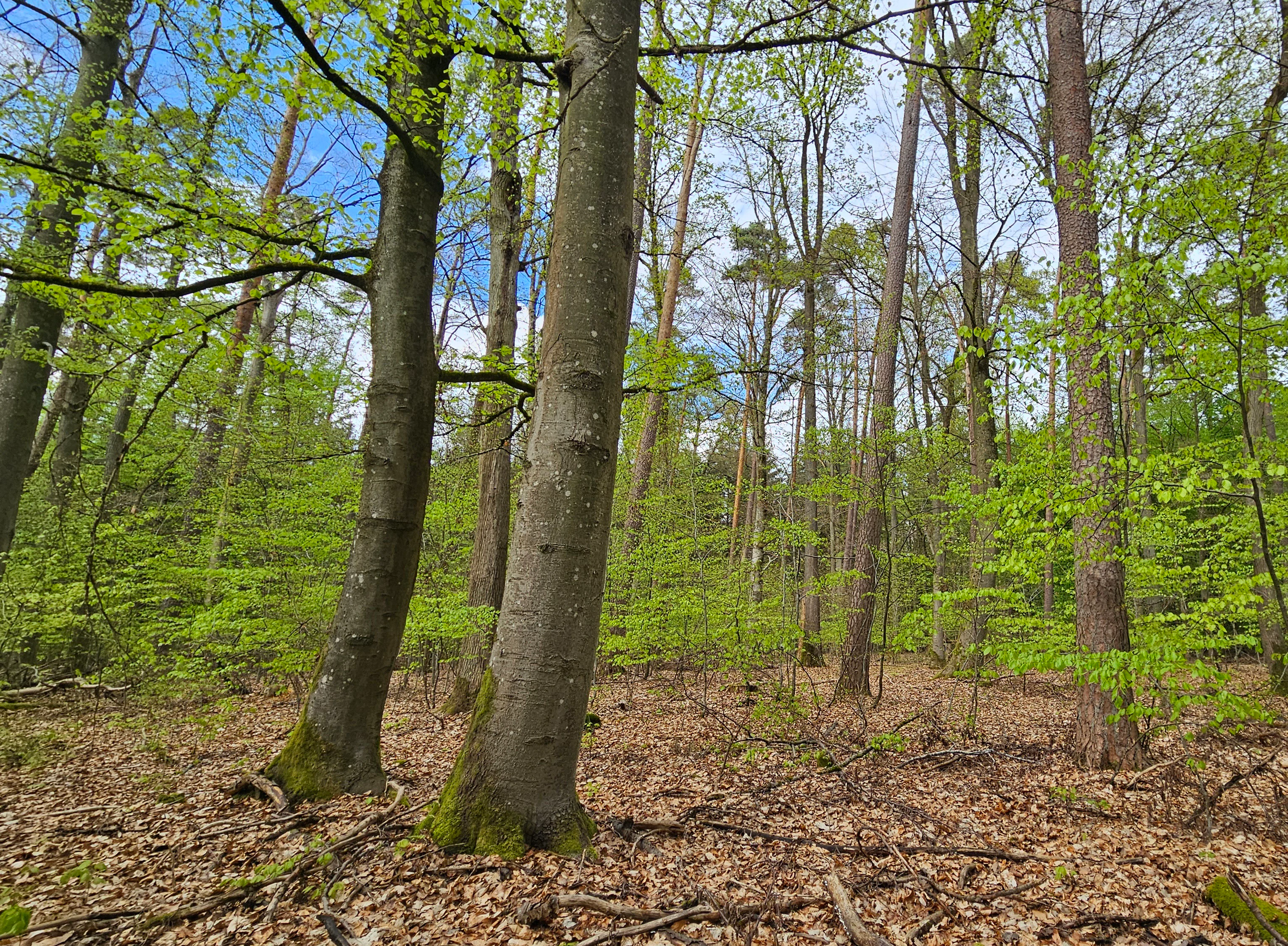
A low-angle view of a forest in early spring with tall mature trees, including beech and pine, with fresh green leaves and a forest floor covered in dry brown leaves.
A view into the natural stands of Naturwald Schlag, characterized by mature deciduous and coniferous trees.

Naturwald Schlag history and protected-area timeline

The history of Naturwald Schlag is closely tied to the evolution of Bavarian forest conservation policy in the early 2020s. In 2019, the Volksbegehren Artenvielfalt und Naturschönheit in Bayern, a popular initiative on biodiversity and natural beauty in Bavaria, prompted the Bavarian state government to commit to removing ten percent of state forest land from active management.

Even before this political decision, the area that would become Naturwald Schlag had already been designated as a so-called Class 1 forest by the Bayerische Staatsforsten, meaning it had been withdrawn from operational timber harvesting. Building on both the earlier classification and the new political mandate, the Bavarian government formally converted this stand into a Naturwald in 2022, placing it under the framework of Article 12a of the Bavarian Forest Act.

Since then, the forest has been permanently left to natural development, with intervention limited to necessary forestry protection and roadway safety. The reserve now stands as a small but durable example of how referendum-driven conservation goals are being translated into specific protected forest stands across Bavaria.

Naturwald Schlag landscape and geographic character

Naturwald Schlag lies within the northern part of the Steigerwald, a German Mittelgebirge, or low mountain range, in northern Bavaria. The terrain here is gently rolling rather than dramatic, with forested slopes, ridges, and small valleys typical of the region. The reserve itself is embedded in a modest forest complex on the southern part of the Landkreis Bamberg, close to the boundary with Middle Franconia to the south.

Near the reserve, the landscape includes low hills such as the Schwalbenzabel at about 367 meters above sea level and the better-known Heuchelheimer Berg at about 391 meters above sea level. Although modest in elevation, the Heuchelheimer Berg is visible from a distance and is a recognizable feature of the local skyline. Small settlements and forested patches alternate across the area, with the villages of Heuchelheim, Thüngfeld, and Schlüsselfeld shaping the local human geography around the forest.

Naturwald Schlag ecosystems, habitats, and plant life

Ecologically, Naturwald Schlag is notable for being an older, near-natural forest stand rather than a plantation or actively managed timber forest. The tree composition is dominated by pine, beech, and oak, a mix that reflects both the region's substrate and the long history of forest use in the Steigerwald. Because the stand has been allowed to age and develop with minimal human interference, it offers a setting where structures such as older trees, uneven age classes, and biodiversity associated with mature woodland can establish over time.

The reserve is part of a network of protected natural forests in Bavaria designed to function as refuges for natural forest dynamics. Within these areas, interventions are limited to safeguarding against acute risks and for public safety, while ecological processes including natural regeneration, decay, and deadwood accumulation are permitted to proceed without management pressure. This makes even very small Naturwald areas like Schlag valuable as reference points for understanding the unmanipulated ecology of central European mixed forests.

Naturwald Schlag wildlife and species highlights

The wildlife value of Naturwald Schlag is closely linked to its character as an older, near-natural mixed forest. Stands of this kind provide habitat features such as decaying wood, hollow trees, and varied canopy layers that support a range of forest-dwelling species, from birds and small mammals to saproxylic insects and other organisms associated with natural forest processes. The site is too small and too newly designated for the source material to support exhaustive claims about specific species inventories, but its ecological role is consistent with that of other Bavarian Naturwald areas set aside for natural development.

Naturwald Schlag conservation status and protection priorities

Naturwald Schlag is a conservation-oriented protected area rather than a working forest. Under Article 12a of the Bavarian Forest Act, Naturwaldreservate and Naturwald areas are places where forestry and timber harvesting are excluded, and the stands are dedicated to natural forest development.

The reserve is the direct result of broader Bavarian and federal conservation goals. The 2019 Volksbegehren Artenvielfalt und Naturschönheit in Bayern led the Bavarian state government to commit to setting aside ten percent of state forest from active use, and Naturwald Schlag is part of translating that commitment into specific, on-the-ground designations. It also contributes to Germany's national strategy for natural forest development, which targets at least five percent of forests being permanently removed from use.

The site has not been reported to the IUCN, and given its very modest area it likely does not meet IUCN size criteria for wilderness areas. Nonetheless, within Bavaria's own framework for natural forests, it serves as a formally protected reference stand where natural forest dynamics can unfold without management intervention.

Naturwald Schlag cultural meaning and human context

The Steigerwald has a long identity as a forested region in northern Bavaria, with traditions of state and communal forestry shaping both its landscape and local culture. Naturwald Schlag reflects a more recent turn in this history, in which formally reserved, unmanaged forest stands increasingly sit alongside traditional working forests. Within the locality, the reserve is associated with the small town of Schlüsselfeld and its district Thüngfeld, both of which lie within the densely wooded parts of Upper Franconia's Bamberg district.

Top sights and standout views in Naturwald Schlag

Naturwald Schlag highlights how very small forest stands can play an outsized symbolic and ecological role when they are formally withdrawn from timber harvesting and left to natural development. The reserve showcases an older mixed forest of pine, beech, and oak in the Steigerwald, and offers a concrete example of how the 2019 Bavarian biodiversity referendum and the national strategy for natural forest development are expressed locally. Its quiet, low-key setting in the rolling landscape near Heuchelheim and Schlüsselfeld reflects both the modest scale of the site and the deliberate intent behind its designation.

Best time to visit Naturwald Schlag

Naturwald Schlag is a tiny protected forest reserve rather than a developed visitor destination, so seasonal planning should focus on the broader character of the Steigerwald rather than on site-specific facilities. Late spring and early summer tend to bring a full canopy and active birdlife, while autumn showcases the beech and oak component of the forest and produces the most unguided walks through the surrounding woodland. Winter visits offer a quieter atmosphere, with bare deciduous trees making it easier to observe the structure of the older, near-natural stand, though visitors should be aware of shortened daylight hours and variable local weather typical of low mountain ranges in northern Bavaria.

Monthly climate preview

Long-term representative monthly temperature and precipitation data for Bavaria

Naturwald Schlag Climate Normals and Annual Temperature Rhythm

Naturwald Schlag exhibits a measured annual climate cycle spanning sub-zero winter minimums and warm summer peaks alongside steady year-round precipitation rates. Examining the full twelve-month profile reveals detailed monthly averages across the representative coordinate.
Annual mean9 °C
-1 °C19 °C
Jan-1°
Feb
Mar
Apr
May13°
Jun17°
Jul19°
Aug19°
Sep14°
Oct
Nov
Dec
Warmest month
July

19.4 °C

Coolest month
January

-1.2 °C

Wettest month
July

2.5 mm/day

Driest month
April

1.3 mm/day

Park location guide

Geography guide, regional context, and park location map for Naturwald Schlag

Naturwald Schlag park geography, regions, and map view in Germany

Understand where Naturwald Schlag sits in Germany through a broader geographic reading of the surrounding landscape, nearby location context, and its mapped position within the national park landscape.

How Naturwald Schlag fits into Germany

Germany is a federal republic in Western and Central Europe with a population of over 83 million across sixteen constituent states. It is Europe's largest economy by nominal GDP and a major global exporter and importer. The capital is Berlin, and the country borders Denmark, Poland, Czech Republic, Austria, Switzerland, France, Luxembourg, Belgium, and the Netherlands.

Wider geography shaping Naturwald Schlag in Germany

Germany is located in Western and Central Europe, spanning 357,022 km². It borders Denmark to the north, Poland and the Czech Republic to the east, Austria and Switzerland to the south, and France, Luxembourg, Belgium, and the Netherlands to the west. The country has coastlines on the Baltic Sea and North Sea to the north, with the Alps located in the southern region.

Map view of Naturwald Schlag

Use this park location map to pinpoint Naturwald Schlag in Germany, understand its exact geographic position, and read its mapped placement within the surrounding landscape more clearly.

Pigeon | © OpenStreetMap contributors

Location context for Naturwald Schlag

Bavaria

Visual exploration of mixed pine, beech, and oak woodland habitats within the Steigerwald low mountain range.

Naturwald Schlag Photos and Landscape Scenery: Protected Forest Imagery

Photographs capture the protected forest environment, mixed tree canopies, and rolling terrain defining Naturwald Schlag within the regional landscape. Visual documentation reveals the unmanaged forest structure, natural regeneration dynamics, and quiet character of this Bavarian natural reserve.

A low-angle view of a forest in early spring with tall mature trees, including beech and pine, with fresh green leaves and a forest floor covered in dry brown leaves.

Park atlas

Compare surrounding forest reserves and regional Bavarian landscapes

Other Parks and Protected Areas Near Naturwald Schlag

Browse protected areas and natural forest reserves located near Naturwald Schlag in the rolling hills of Upper Franconia. Expanding the map view reveals adjacent conservation sites and regional terrain connections across the northern Steigerwald.
Watercolor painting of a forest landscape with a grassy clearing and distant hills, rendered in soft green and pink tones.
Nature reserveGermany
About 16 km away#1 closest

Northwest

Naturwald Waldhaus: Geographic Mapping of an Ancient Beech Reserve in Steigerwald, Bavaria

Protected natural woodland and forest biodiversity in northern Germany.

Naturwald Waldhaus stands as a prime example of a protected forest in the Steigerwald, recognized for its exceptionally old beech stands and documented saproxylic beetle populations. This nature reserve provides essential ecological continuity within the Bamberg district, representing a rare, undisturbed woodland landscape that serves as a cornerstone for forest research in southern Germany.

Area
1.062 km²
Established
1978
Relief
Upland
Climate
Temperate
Nature reserveLandkreis Haßberge
About 17 km away#2 closest

North

Schulterbachtal Nature Reserve: Mapped Geography and Protected Wetland Landscapes in Bavaria

A focused analysis of the Steigerwald wetland and brook habitats

Schulterbachtal occupies a protected valley floor within the Haßberge district, characterized by its near-natural stream, extensive wet meadow communities, and characteristic alder-ash woodland belts. As a key segment of the northern Steigerwald ecosystem, this site demonstrates the ecological significance of managed cultural landscapes and provides a detailed view of its hydrological and vegetative terrain.

Area
0.341 km²
Established
1990
IUCN
IV
Watercolor painting showing rolling green hills, trees in the midground, and purple-tinted mountains in the background against a white backdrop.
Nature reservePrichsenstadt
About 18 km away#3 closest

Northwest

Naturwald Krackentännig Nature Reserve: A Protected Forest Landscape in Northern Bavaria

Geography of the Steigerwaldvorland and Gänsseegraben valley floor

Situated near Prichsenstadt, Naturwald Krackentännig acts as a refuge for ash and alder trees that thrive in the moist soils of the Lower Franconian countryside. This nature reserve provides a critical example of undisturbed forest development, showcasing a specialized ecosystem within the rolling hills of the Steigerwaldvorland and a commitment to preserving small-scale woodland habitats.

Area
0.026 km²
Established
2021
Relief
Lowland
Scope
Terrestrial
A soft watercolor illustration of rolling hills and gentle terrain in shades of pale green and muted earth tones against a white background.
Protected landscapeMittelfranken
About 19 km away#4 closest

South

Naturpark Frankenhöhe Protected Landscape: Geography, Map, and Regional Conservation Context

Explore the diverse natural terrain of the Mittelfranken region in Bavaria.

Naturpark Frankenhöhe serves as a significant protected landscape in western Mittelfranken, encompassing a unique mosaic of forests, vineyards, and agricultural valleys. This geographic entity is shaped by the European Main Watershed, where rivers divide between the Rhine and Danube systems. Its terrain provides a study in transitions, from higher forested crests to open orchard meadows that define the local Bavarian countryside.

Area
1,104.06 km²
Established
1974
Relief
Mixed relief
Climate
Temperate
A watercolor illustration depicting a soft, rolling landscape of green hills, distant mountain silhouettes, and a winding stream.
Protected areaBavaria
About 20 km away#5 closest

West

Naturwald Speckfeld: Protected Forest Reserve and Steigerwald Geographic Detail

Broadleaf woodland and gypsum ridge landscapes in Bavaria

Naturwald Speckfeld offers a look into unharvested forest dynamics within the Steigerwald mountains. This protected area stands out for its steep topography, historical castle ruins, and rare broadleaf woodland transitions, providing a critical reference point for natural forest conservation in the Lower Franconia region of Bavaria.

Area
0.195 km²
Established
1978
Relief
Upland
Climate
Temperate
Nature reserveLandkreis Haßberge
About 20 km away#6 closest

North

Naturwald Wotansborn: A Protected Old-Growth Beech Reserve in the Heart of the Steigerwald

Ancient forest geography within the Haßberge district

Naturwald Wotansborn is a protected woodland enclave that preserves centuries-old beech trees and high concentrations of deadwood habitat. Located in the Steigerwald of Landkreis Haßberge, this reserve offers a window into natural forest cycles, housing the historic Wotansborn spring and a vital corridor for amphibian life along the Erlesbach stream.

Area
0.033 km²
Established
2020
IUCN
IV
Relief
Upland
A watercolor painting of a rolling landscape with scattered trees, grasslands, and soft rolling hills in the background, rendered in pale pastel tones.
Nature reserveUnterfranken
About 24 km away#7 closest

West

Sande am Tannenbusch bei Kleinlangheim Nature Reserve: Protected Area and Atlas Overview

Geography of the Steigerwaldvorland sand landscape

Discover the ecological composition of Sande am Tannenbusch bei Kleinlangheim, a nature reserve in Unterfranken defined by its inland sand deposits and fragmented woodland footprint. This site is significant for its sand grassland mosaic, serving as a primary habitat for farmland birds and representing a specialized enclave within the broader Klosterforst region.

Area
0.382 km²
Established
1995
IUCN
IV
Relief
Lowland
A soft watercolor painting of a rolling forested landscape with green hills and trees on a white background.
Nature reserveBayern
About 24 km away#8 closest

North

Naturwald Knetzberge-Böhlgrund Nature Reserve and Steigerwald Forest Geography

A mapped overview of protected broadleaf forests in Lower Franconia.

Spanning over 800 hectares, Naturwald Knetzberge-Böhlgrund is a major protected forest entity in the Steigerwald that integrates mature stands, deadwood habitats, and steep valley topographies. This area offers a unique perspective on natural forest succession and ecological preservation within the German landscape, marked by its distinct sandstone ridges and high biodiversity.

Area
8.474 km²
Established
2020
Relief
Mountain
Climate
Temperate

Common questions about visiting, size, designation, and location context for Naturwald Schlag

Naturwald Schlag FAQs for park facts, access, geography, and protected area context

Find quick answers about Naturwald Schlag, including protected-area facts, park geography, trail and visitor context, and how the park fits into its surrounding country and regional landscape.
MoriAtlas Explorer

Continue Your Protected Areas Search Across the Global Atlas

Deepen your exploration by continuing the structured search for national parks and protected areas worldwide. Utilize the comprehensive filtering capabilities to compare different conservation landscapes and refine your understanding of global park geography. Discover more about the distribution and characteristics of protected natural areas.

Global natural geography