

Mori Atlas logo
National parkNavegaon National Park

Explore the mapped boundaries and geographic context of this significant protected area.

Navegaon National Park: A Protected National Park Landscape in Maharashtra

Navegaon National Park represents a key protected landscape within Maharashtra, India, designated as a national park for its conservation significance. This page serves as a gateway to understanding the park's geographic identity and its place within the regional atlas. Users can explore the mapped extent of Navegaon National Park and gain insight into its surrounding natural terrain, contributing to a structured discovery of protected areas in India.

National ParkBird SanctuaryTiger ReserveDeciduous ForestEastern MaharashtraWetland Ecosystem

Navegaon National Park

National park

Park overview

Structured park overview, official facts, and landscape profile for Navegaon National Park

Navegaon National Park park facts, protected area profile, and essential visitor context
Review the core facts for Navegaon National Park, including designation, size, terrain, visitor scale, habitats, and operating context in one park-focused overview.

About Navegaon National Park

Navegaon National Park represents a significant protected area in eastern Maharashtra's Gondia district, situated within the Arjuni Tahsil region. The park was formally established in November 1975 and functions as a critical component of the broader Nawegaon Nagzira Tiger Reserve, which covers a substantially larger area of approximately 1,895 square kilometers. The national park's central feature is the Navegaon lake, a historic water body with origins dating to around 1300 AD when it was constructed under the direction of the Kohali community working for Rani Durgawati, queen of the Gond kings. This historical dam, originally managed by villagers and later taken over by the government in 1951, created the reservoir that now defines the park's character and ecological function. The park's location in the Deccan Peninsula biogeographic zone places it in one of India's least protected but biodiversity-rich regions, making its conservation role particularly significant. The area serves as an important ecological corridor, providing habitat connectivity for large mammals including tigers and leopards while supporting the needs of local communities through ecosystem services.

Quick facts and research context for Navegaon National Park

Navegaon National Park lies in Gondia district of eastern Maharashtra, approximately 20.933°N latitude and 80.167°E longitude. The park was established in 1975 and encompasses tropical dry deciduous forest ecosystems. It contains the Salim Ali Bird Sanctuary, which hosts nearly 60% of Maharashtra's bird species. The landscape features elevation ranges from 30 meters to 702 meters above sea level, with terrain including steep ridges, narrow valleys, and deep gorges. The park supports 209 bird species, 26 mammal species, and 9 reptile species, alongside diverse botanical resources including teak, haldu, jamun, and mahua trees.

Park context

Deeper park guide and search-rich context for Navegaon National Park

Navegaon National Park history, landscape, wildlife, and travel context
Explore Navegaon National Park through its history, landscape character, ecosystems, wildlife, conservation priorities, cultural context, and seasonal travel timing in a structured park guide built for atlas discovery and search intent.

Why Navegaon National Park stands out

Navegaon National Park is best known for its exceptional avian diversity, with the Salim Ali Bird Sanctuary supporting nearly 60% of all bird species recorded in Maharashtra. The park's historic lake attracts substantial winter migratory bird populations annually. It is also recognized as a key tiger conservation area within the Nawegaon Nagzira Tiger Reserve, supporting populations of tigers, leopards, sloth bears, gaurs, and sambar deer. The combination of rich birdlife, significant mammal populations, and the park's cultural heritage stemming from its 14th-century lake construction makes it distinctive among Maharashtra's protected areas.

Navegaon National Park history and protected-area timeline

The history of Navegaon National Park is deeply intertwined with the construction of its central lake, which dates to approximately 1300 AD during the reign of Gond king Dalpatshah. The lake was constructed under the patronage of Rani Durgawati, who commissioned the Kohali community, known for their expertise in excavation and stone construction, to build the reservoir to support agricultural development in the region. Two brothers from the Kohali community, Kolhu and Chimna Patil, were delegated the task of constructing the lake and simultaneously resettling inhabitants of twelve villages displaced by the dam's construction. The construction employed hundreds of laborers paid in conches and mollusc shells, with cattle herds used to consolidate the dam wall through trampling. A temple to Hanuman was built alongside the dam, and a 200-yard waste weir was constructed to allow eel fish from coastal backwaters to enter the lake for spawning. After completion, the dam was taken over by the government in 1951. The area was subsequently declared a national park on 22 November 1975, formalizing its protection status. The park also contains the island known as Maldonger, historically used by villagers as refuge from marauding Pindaris.

Navegaon National Park landscape and geographic character

The landscape of Navegaon National Park features diverse terrain characterized by elevations ranging from approximately 30 meters above sea level to 702 meters at the sanctuary's highest point. The topography includes steep ridges, narrow valleys, and deep gorges that create varied microhabitats throughout the park. The geological formations belong to the Sakoli Series, comprising phyllites, slates, and chlorites, alongside the Saucer Series with distinct mineral composition including felspar and biolite. This geological diversity contributes to the park's varied terrain and soil characteristics. The park is centered around the Navegaon lake, a significant water body that serves as the ecological heart of the protected area. The surrounding landscape supports a mosaic of forest types transitioning from dry mixed forest in lower elevations to moist forest in higher areas, creating a heterogeneous environment that supports diverse flora and fauna.

Navegaon National Park ecosystems, habitats, and plant life

The ecological character of Navegaon National Park is defined by its position in the Deccan Peninsula biogeographic zone, classified as Sub Kingdom Indomalaysian within the Paleotropical Bio-geographic Kingdom. The park's vegetation belongs to the Southern Tropical Dry Deciduous Forest type, classified as 5 A/C3 under the Champion and Seth forest classification system. This forest type supports a remarkable diversity of plant species, including economically and medicinally valuable species such as teak, haldu, jamun, kawat, mahua, ain, bhel, and bhor. The park serves as a living repository of aromatic and ornamental plant species, contributing to its ecological significance. The lake ecosystem supports additional biodiversity, particularly avian species, with the Salim Ali Bird Sanctuary hosting nearly 60% of Maharashtra's total bird species. The park functions as a critical green lung for surrounding human settlements, contributing to environmental balance and air quality regulation in the heavily populated region of eastern Maharashtra.

Navegaon National Park wildlife and species highlights

Navegaon National Park supports impressive wildlife diversity across multiple taxonomic groups. The mammal population includes 26 species, with notable large carnivores such as tigers and leopards (Panthera pardus) present within the park boundaries. Other significant mammals include sloth bears, gaurs (Bos gaurus), sambars (Rusa unicolor), chitals, and various primate species including langurs. Smaller mammals include jungle cats, small Indian civets, palm civets, wolves, jackals, and wild boars. The avian fauna is particularly remarkable, with 209 bird species recorded within the park, representing nearly 60% of all bird species found throughout Maharashtra. The park's lake attracts substantial winter migratory bird populations annually. Reptile diversity includes 9 species, while fish populations contribute to the aquatic ecosystem's complexity. The vertebrate fauna overall demonstrates the park's importance as a biodiversity conservation unit in central India, particularly within the relatively under-protected Deccan Peninsula biogeographic region.

Navegaon National Park conservation status and protection priorities

Navegaon National Park holds significant conservation importance as part of the Nawegaon Nagzira Tiger Reserve, representing one of the least protected biogeographic zones in India despite its rich floral and faunal diversity. The park serves as a critical conservation unit in central India, particularly for the Vidarbha region of Maharashtra. Its designation as an Important Bird Area due to the Salim Ali Bird Sanctuary's exceptional avian population underscores its conservation significance. However, the park faces ongoing challenges from human-wildlife conflict, with tigers and leopards occasionally killing domestic livestock in neighboring villages, resulting in economic impacts on local communities and antagonism toward management efforts. Historical records indicate that in some years, up to three people and 30-50 cattle have been lost to large carnivore predation. The park's role as an ecological corridor connecting larger wilderness areas makes it important for maintaining genetic connectivity for species including tigers, which require extensive home ranges. Conservation efforts focus on balancing protection objectives with the needs of local communities who depend on the surrounding landscape.

Navegaon National Park cultural meaning and human context

The cultural context of Navegaon National Park is deeply rooted in the region's tribal heritage and historical governance. The area was historically under the rule of Gond kings, with the lake's construction in approximately 1300 AD linked to Queen Rani Durgawati's agricultural development initiatives. The Kohali community, who constructed the dam, were awarded farming tracts and granted the title of Patel or Patil for their role in building the water infrastructure. The local name Navegaon derives from Marathi words Nave meaning new and gaon meaning village, while the alternative name Navegaon Bandh references the dam (bandh) that created the lake. Predominantly tribal populations continue to inhabit the surrounding region, maintaining traditional relationships with the landscape. The island within the lake, known as Maldonger, historically served as a refuge for villagers during periods of instability. The park's cultural heritage layer adds significance beyond its ecological value, connecting contemporary conservation efforts to centuries of human interaction with this landscape.

Top sights and standout views in Navegaon National Park

Navegaon National Park's standout features include the historic Navegaon lake with its 14th-century construction heritage, the Salim Ali Bird Sanctuary supporting exceptional bird diversity, and its role within the tiger conservation landscape of central India. The park offers unique visitor experiences including jungle safaris, tree-top accommodations, and boat rides on the lake. The elevation range from 30 to 702 meters creates diverse habitats supporting both dry and moist forest types. Nearby attractions include Nagzira Wildlife Sanctuary 60 kilometers away, Itiadoh Dam 20 kilometers distant, and the Tibetan Camp at Gothangaon 15 kilometers from the park. Nearly 50,000 tourists visit annually, drawn by the combination of natural beauty, wildlife viewing opportunities, and cultural historical significance. The geological diversity featuring Sakoli and Saucer Series formations adds scientific interest to the park's appeal.

Best time to visit Navegaon National Park

The optimal time to visit Navegaon National Park depends on the experience sought. Winter months from November to February bring migratory birds to the lake, making this period particularly rewarding for birdwatchers and wildlife enthusiasts. The cooler temperatures during these months also make outdoor exploration more comfortable. The summer months from March to May offer excellent opportunities for wildlife viewing as animals congregate at water sources, though temperatures can be high. The monsoon season from June to September brings lush green landscapes but may limit access to some areas and wildlife sightings become less predictable. The park's diverse ecosystems ensure that each season offers distinct experiences, whether viewing winter bird arrivals, summer wildlife activity, or the monsoon-transformed landscape.
Park location guide

Geography guide, regional context, and park location map for Navegaon National Park

Navegaon National Park park geography, regions, and map view in India
Understand where Navegaon National Park sits in India through a broader geographic reading of the surrounding landscape, nearby location context, and its mapped position within the national park landscape.

How Navegaon National Park fits into India

India is a South Asian country bordered by the Indian Ocean, Arabian Sea, and Bay of Bengal. It shares land borders with Pakistan, China, Nepal, Bhutan, Bangladesh, and Myanmar. The country has a population of over 1.4 billion people and operates as a federal parliamentary republic with its capital in New Delhi.

Wider geography shaping Navegaon National Park in India

India occupies the Indian subcontinent in South Asia, bordered by the Arabian Sea to the southwest, the Bay of Bengal to the southeast, and the Indian Ocean to the south. It shares land borders with Pakistan to the west, China, Nepal, and Bhutan to the north, and Bangladesh and Myanmar to the east. The territory also includes the Andaman and Nicobar Islands in the Indian Ocean.

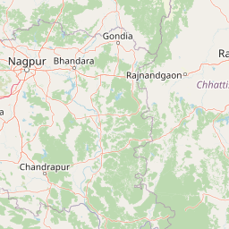
Map view of Navegaon National Park

Use this park location map to pinpoint Navegaon National Park in India, understand its exact geographic position, and read its mapped placement within the surrounding landscape more clearly.

Pigeon | © OpenStreetMap contributors

Location context for Navegaon National Park

Gondia districtMaharashtra
Park atlas

Map the regional geography of protected areas, comparing national parks and wildlife sanctuaries in Eastern Maharashtra near Navegaon National Park.

Explore Nearby Protected Areas: National Parks and Wildlife Sanctuaries Around Navegaon National Park
Browse national parks and wildlife sanctuaries in Eastern Maharashtra, exploring diverse protected areas and conservation landscapes adjacent to Navegaon National Park. Continue your atlas discovery by comparing mapped terrain, forest types, and ecological corridors across this region, understanding the broader protected area context.
National parkChandrapur district

Tadoba Andhari Tiger Reserve National Park: Mapped Protected Landscape Discovery

Geographic context within Chandrapur district, India.

Investigate Tadoba Andhari Tiger Reserve as a national park, focusing on its distinct protected landscape characteristics. This detail page provides structured insights into its mapped boundaries and its position within the regional geography of Chandrapur district, essential for a comprehensive understanding of India's protected natural areas.

Area
1,727.59 km²
Established
1955
IUCN
II
Relief
Highland
National parkMadhya Pradesh

Pench National Park: Madhya Pradesh National Park Protected Landscape Overview

Mapped geographic context and protected area boundaries

Pench National Park is a designated national park situated in Madhya Pradesh, India, offering a distinct protected landscape for geographic study. This entry provides detailed insights into its mapped terrain, allowing for an atlas-style exploration of its protected boundaries and its significance within the regional geography. Understand the park's place in the landscape and its value for conservation-focused map exploration.

Area
292.85 km²
Established
1983
IUCN
II
Relief
Upland
National parkMadhya Pradesh

Kanha National Park: A Madhya Pradesh Protected Landscape for Atlas Exploration

Mapped park boundaries and regional geographic context.

Kanha National Park serves as a vital protected area, offering critical insights into India's natural geography. This entry facilitates detailed atlas-style exploration of its mapped landscape and protected territory within Madhya Pradesh. Understand the park's geographic definition and its role within the broader context of India's conservation lands, providing a foundation for structured geographic discovery.

Area
940 km²
Established
1955
IUCN
II
Visitors
213.8K annual
National parkBijapur district

Indravati National Park: National Park Status and Geographic Landscape Context

Explore mapped boundaries and regional geography in Bijapur district.

Indravati National Park represents a significant protected natural area, classified as a national park within India. This entry offers detailed insights into its geographic placement within Bijapur district, emphasizing its mapped protected landscape and its role in regional geography. It serves as a vital point for structured discovery of natural areas and their environmental context.

Area
1,258.37 km²
Established
1981
IUCN
II
Relief
Highland
National parkMadhya Pradesh

Ghughua Fossil Park National Park: Mapped Geography and Protected Area Context in Madhya Pradesh

Explore the mapped boundaries and regional landscape of Ghughua Fossil Park.

Ghughua Fossil Park stands as a designated national park within the expansive geography of Madhya Pradesh, India. This resource facilitates a detailed exploration of its protected landscape, offering insights into its geographic setting and the significance of its mapped boundaries. Understand the park's place within the regional atlas and its role as a key conservation territory.

Area
0.3 km²
Established
1983
IUCN
II
Access
Access unknown
National parkUmaria district

Bandhavgarh National Park: A Protected Landscape in India's Umaria District

Explore the geographic boundaries and mapped terrain.

Bandhavgarh National Park is a designated national park offering a unique glimpse into India's protected landscapes. Located within Umaria district, its geographic features and mapped terrain provide valuable context for atlas exploration. Understanding the park's protected area status and its place within the regional geography is key to appreciating its role as a vital natural landscape.

Area
105 km²
Established
1968
IUCN
II
Visitors
176.1K annual
National parkMadhya Pradesh

Sanjay National Park: Madhya Pradesh Protected Area with Hilly Terrain and Dry Deciduous Forests

Explore the mapped boundaries and landscape context of this national park.

Sanjay National Park, situated in Madhya Pradesh, India, is a substantial protected area recognized for its significant role in conservation. The park features a landscape dominated by hilly terrain and extensive dry deciduous forests, bisected by the Banas River. As a national park and tiger reserve, its mapped geography supports a rich ecosystem and is vital for understanding the protected lands of central India.

Area
1,674.55 km²
Established
1981
IUCN
II
Relief
Highland
Wildlife reserveChhattisgarh

Guru Ghasidas - Tamor Pingla Tiger Reserve: Wildlife Reserve in Chhattisgarh's Mapped Landscapes

Explore protected area geography and regional context.

Guru Ghasidas - Tamor Pingla Tiger Reserve, identified as a wildlife reserve, offers detailed insight into its protected landscape and geographic positioning within Chhattisgarh. Users can explore its mapped boundaries and understand its contribution to the region's natural terrain. This resource focuses on the atlas-style discovery of protected areas, providing a clear picture of the reserve's environmental context and regional significance without delving into visitor logistics.

Area
2,829.38 km²
Established
2024
IUCN
II
Relief
Mixed relief

Common questions about visiting, size, designation, and location context for Navegaon National Park

Navegaon National Park FAQs for park facts, access, geography, and protected area context
Find quick answers about Navegaon National Park, including protected-area facts, park geography, trail and visitor context, and how the park fits into its surrounding country and regional landscape.
MoriAtlas Explorer

Continue Your Protected Areas Search Across the Global Atlas

Deepen your exploration by continuing the structured search for national parks and protected areas worldwide. Utilize the comprehensive filtering capabilities to compare different conservation landscapes and refine your understanding of global park geography. Discover more about the distribution and characteristics of protected natural areas.

Global natural geography