

Mori Atlas logo
National parkNechisar National Park

Discover the mapped boundaries and natural terrain of this key Ethiopian national park.

Nechisar National Park: Protected Landscape & Regional Geography in South Ethiopia

Nechisar National Park stands as a protected national park entity within the diverse geography of South Ethiopia Regional State. This page offers an atlas-centric view, detailing the park's landscape context and its position within the mapped protected areas of southern Ethiopia. Explore the geographic scope and protected land identity that define Nechisar National Park for structured discovery.

Rift Valley parksLake ecosystemsAcacia savannaWildlife viewingCrocodile habitatHighland interfaces

Nechisar National Park

National park

Park overview

Structured park overview, official facts, and landscape profile for Nechisar National Park

Nechisar National Park park facts, protected area profile, and essential visitor context
Review the core facts for Nechisar National Park, including designation, size, terrain, visitor scale, habitats, and operating context in one park-focused overview.

About Nechisar National Park

Nechisar National Park occupies a remarkable position in Ethiopia's protected area system, situated where the Great Rift Valley slices through the southwestern Ethiopian Highlands. The park's defining feature is the Bridge of God, a narrow isthmus of land between Lake Abaya and Lake Chamo, two substantial freshwater bodies that together form a significant portion of the park's western boundary. This geography creates a park that is partially aquatic, with approximately 15 percent of its area covered by these interconnected lakes, while the remaining landscape consists of groundwater forests along the shorelines, dry grassy plains, and acacia-dominated woodland that extends onto the Nechisar plains east of the lakes. The park's elevation gradient from the lakeshore at 1,108 meters up to 1,650 meters on Mount Tabala in the northeast creates environmental diversity, with Mount Tabala being particularly notable for its hot springs that emerge from the highlands. Arba Minch, the primary regional center serving the area, lies approximately 15 kilometers west of the park boundary. The park protects a transitional zone between Rift Valley lacustrine environments and highland ecosystems, making it ecologically significant despite not having been formally gazetted since its establishment in 1974.

Quick facts and research context for Nechisar National Park

Nechisar National Park lies in the Great Rift Valley of southwestern Ethiopia, approximately 15 kilometers east of the town of Arba Minch. The park covers roughly 1,030 square kilometers and is defined by its unique geography: a narrow land bridge between two major Rift Valley lakes, Lake Abaya and Lake Chamo, bordered by the Nechisar plains to the east. The landscape encompasses about 15 percent lake surface area alongside groundwater forests, acacia woodland, and edaphic grasslands. Elevation ranges from 1,108 meters at the southern lake shore to 1,650 meters on Mount Tabala in the northeast, where notable hot springs emerge. The park was established in 1974 and is managed by the Ethiopian Wildlife Conservation Authority.

Park context

Deeper park guide and search-rich context for Nechisar National Park

Nechisar National Park history, landscape, wildlife, and travel context
Explore Nechisar National Park through its history, landscape character, ecosystems, wildlife, conservation priorities, cultural context, and seasonal travel timing in a structured park guide built for atlas discovery and search intent.

Why Nechisar National Park stands out

Nechisar National Park is most distinctive for its extraordinary setting at the intersection of two major Rift Valley lakes, creating the narrow Bridge of God isthmus that defines the park's core geography. The park is renowned for the Crocodile Market, a stretch of northwestern Lake Chamo shore where hundreds of Nile crocodiles congregate to bask. The park also holds significant conservation importance as a remaining refuge for Swayne's hartebeest, though the species is now believed locally extinct following the last confirmed sighting in 2017. The dramatic contrast between the lake-filled western section and the open grassy plains to the east, combined with views of the Ethiopian Highlands rimming the horizon, gives the park a distinctive visual character within Ethiopia's protected area network.

Nechisar National Park history and protected-area timeline

Nechisar National Park was first proposed in 1967 and officially established in 1974 as part of Ethiopia's developing national park system. However, since its establishment the park has not undergone formal legal gazetting, meaning it has operated as a de facto protected area rather than a fully designated national park under Ethiopian law. A significant historical event occurred in 1982 when the Ethiopian Ministry of Agriculture recommended the forcible eviction of the Guji people, who had been living as pastoralists in the lowlands beside Lake Abaya and Lake Chamo. This eviction was carried out at gun point, displacing communities that had traditional connections to the land. During the turbulent period at the end of Derg rule and the subsequent political transition, the park suffered considerable damage, with park buildings located away from headquarters being looted and destroyed. The Guji, displaced by this eviction, returned to their traditional grazing areas during this lawless period, reportedly fleeing attacks from the Borena Oromo. This return and subsequent resistance to further eviction efforts created ongoing management challenges. In 2005, Refugees International publicly criticized the eviction of the Guji, highlighting the human rights dimensions of the park's conservation history. The park's wildlife also suffered during these unstable periods, with several species experiencing significant population declines or local extinction.

Nechisar National Park landscape and geographic character

The landscape of Nechisar National Park presents a striking combination of aquatic and terrestrial environments shaped by Rift Valley geology. The western portion of the park is dominated by the two major lakes, Lake Abaya in the north and Lake Chamo in the south, which together comprise roughly 15 percent of the park's total area. Between these lakes lies the narrow Bridge of God isthmus, a geological feature that creates the park's most distinctive visual element. The shoreline areas feature groundwater forests that buffer the transition between open water and terrestrial environments. Moving eastward from the lakes, the landscape opens into the Nechisar plains, characterized by dry grassy areas and acacia woodland. The southern park territory features edaphic grasslands growing over calcareous black clay soils, with distinctive vegetation including Dobera glabra, Acacia tortilis, and Chrysopogon aucheri grass. The northeastern boundary includes Mount Tabala, rising to 1,650 meters, where hot springs emerge as another notable geological feature. The park's elevation range of approximately 540 meters from lake shore to highland creates visual drama, with the highlands forming a backdrop to the lake-filled western section. Common trees throughout the park include Dichrostachys cinerea, Acacia tortilis, Balanites aegyptiaca, and the less frequent Acacia nilotica.

Nechisar National Park ecosystems, habitats, and plant life

The nature of Nechisar National Park reflects its position at an ecological crossroads between Rift Valley lake systems and highland environments. The park contains several distinct habitat types that support diverse biological communities. The lake environments of Lake Abaya and Lake Chamo provide extensive aquatic habitat, while the groundwater forests along their shores create unique riparian zones. The dry grassy plains and acacia woodland represent savanna ecosystems adapted to the Rift Valley's climate patterns. The edaphic grasslands in the southern portion develop on specific soil types that influence vegetation composition. This habitat diversity supports the park's ecological significance within Ethiopia's protected area network. However, the park faces environmental challenges including invasive species and woody plant encroachment that threaten biodiversity. The tension between conservation objectives and human land use pressures has shaped the park's ecological trajectory, particularly since the displacement of pastoralist communities in the 1980s altered traditional land management patterns.

Nechisar National Park wildlife and species highlights

Nechisar National Park supports a notable assembly of large mammals characteristic of Ethiopian savanna ecosystems. The plains zebra and Grant's gazelle represent the most commonly observed ungulates across the grassland areas. Antelope species present include dik-dik, greater kudu, waterbuck, and bushbuck, while larger predators include African leopard, spotted hyena, and lion, with an estimated population of fewer than 23 lions recorded in 2009. Cheetah also occur within the park. Hippopotamus frequent the lake margins, particularly in Lake Chamo where their wallowing creates channels and pools along the shoreline. Primates include Anubis baboon and vervet monkeys, while smaller mammals include bushpig and black-backed jackal. The park historically held one of the last three remaining populations of Swayne's hartebeest, a distinctive Ethiopian endemic, but the last individual was sighted in 2017 and the species is now believed locally extinct. The African wild dog, once present in the park, is now considered possibly locally extinct due to human population pressures. Birdlife is particularly notable along the lake shores, with kingfishers, storks, pelicans, flamingos, and African fish eagles commonly observed. The Crocodile Market stretch of Lake Chamo's northwest shore supports remarkable concentrations of Nile crocodiles, with hundreds basking together in what represents one of the park's most famous wildlife spectacles.

Nechisar National Park conservation status and protection priorities

Nechisar National Park represents both the potential and the challenges of conservation in Ethiopia's Rift Valley region. The park was established in 1974 but has operated without formal legal gazetting, creating institutional uncertainty about its protected status. The park is managed by the Ethiopian Wildlife Conservation Authority, which oversees its de facto national park status despite the lack of formal legal designation. Conservation challenges have been severe, particularly during periods of political instability when park infrastructure was damaged and wildlife populations declined. The eviction of pastoralist communities in 1982, while intended to reduce human pressure on wildlife, created new tensions and ultimately proved difficult to enforce, with communities returning during the lawless period following Derg rule. The loss of Swayne's hartebeest as a breeding population represents a significant conservation failure, though the park continues to protect important habitat for remaining species including lion, leopard, and various ungulates. The threats from invasive species and woody plant encroachment continue to affect biodiversity, while human population growth in the surrounding region creates ongoing pressure on park resources.

Nechisar National Park cultural meaning and human context

The cultural context of Nechisar National Park is deeply tied to the history of the Guji people, an Oromo community whose traditional lands encompassed portions of the current park area. The Guji lived as pastoralists in the lowlands beside Lake Abaya and Lake Chamo for generations, maintaining traditional land use patterns that intersected with the landscapes now protected by the park. The 1982 eviction, carried out at gun point on recommendations from the Ethiopian Ministry of Agriculture, fundamentally altered the human landscape of the region and created lasting tensions. During the chaotic period at the end of Derg rule, the Guji returned to their traditional areas, reportedly fleeing attacks from the Borena Oromo, and acquired firearms to resist subsequent eviction attempts. The 2005 criticism from Refugees International drew attention to the human costs of conservation in the park, highlighting the displacement of communities that had historically coexisted with the landscapes now protected. This history illustrates the complex relationship between conservation designations and indigenous communities in Ethiopian protected areas, where the establishment of parks has sometimes conflicted with the rights and livelihoods of long-resident populations.

Top sights and standout views in Nechisar National Park

The Bridge of God isthmus connecting Lake Abaya and Lake Chamo represents Nechisar's most distinctive geographical feature and the heart of the park's identity. The Crocodile Market on Lake Chamo's northwest shore, where hundreds of Nile crocodiles gather in spectacular concentration, offers one of Ethiopia's most remarkable wildlife viewing experiences. The contrast between the lake-filled western section and the open Nechisar plains to the east creates visual diversity within a single park visit. The hot springs of Mount Tabala in the northeastern park provide a geological attraction unique to the area. The park's position within the Great Rift Valley, with Ethiopian Highlands rising in the background, frames scenery that combines lowland and highland elements. The open grasslands support visible populations of plains zebra and Grant's gazelle, while the lakes provide habitat for hippos, waterfowl, and the famous crocodile gatherings. Though the loss of Swayne's hartebeest represents a conservation setback, the park continues to protect significant populations of lions, leopards, and diverse savanna fauna.

Best time to visit Nechisar National Park

The optimal time to visit Nechisar National Park falls during the dry seasons, typically from October through March, when wildlife congregates more densely around remaining water sources and vegetation is less dense, improving visibility for game viewing. The dry season conditions create optimal conditions for observing hippos along the lake shores and crocodiles at Crocodile Market. The period from December to February often offers the clearest skies and most comfortable temperatures for park exploration. The wet seasons, from April to May and June to September, bring higher vegetation that can make wildlife more difficult to spot but also transform the landscape with fresh growth. The park can be visited year-round, though conditions vary significantly between seasons. The proximity to Arba Minch provides a convenient base for park visits, though visitors should be aware that the park has operated without formal gazetting, which may affect infrastructure and services compared to more officially designated protected areas.
Park location guide

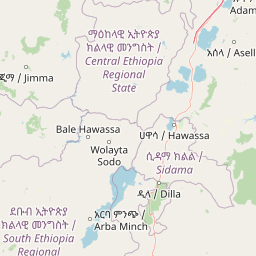
Geography guide, regional context, and park location map for Nechisar National Park

Nechisar National Park park geography, regions, and map view in Ethiopia
Understand where Nechisar National Park sits in Ethiopia through a broader geographic reading of the surrounding landscape, nearby location context, and its mapped position within the national park landscape.

How Nechisar National Park fits into Ethiopia

Ethiopia is a landlocked federal parliamentary republic located in the Horn of Africa. With a population of approximately 135 million people, it is the 14th-most populous country in the world and the most populous landlocked country. The country is known for its ancient history, diverse ethnic groups, and the capital Addis Ababa, which lies near the East African Rift.

Wider geography shaping Nechisar National Park in Ethiopia

Ethiopia is located in the Horn of Africa, bordered by Eritrea to the north, Djibouti to the northeast, Somalia to the east, Kenya to the south, South Sudan to the west, and Sudan to the northwest. The country sits on the African and Somali tectonic plates, with the East African Rift running through it. The terrain includes highlands, valleys, and lowlands.

Map view of Nechisar National Park

Use this park location map to pinpoint Nechisar National Park in Ethiopia, understand its exact geographic position, and read its mapped placement within the surrounding landscape more clearly.

Pigeon | © OpenStreetMap contributors

Location context for Nechisar National Park

South Ethiopia Regional State
Park atlas

Trace the geographic context and compare protected areas adjacent to Nechisar National Park's unique Rift Valley setting.

Browse Nearby National Parks and Protected Areas Surrounding Nechisar National Park
Continue your exploration of Ethiopia's conservation landscapes by discovering other national parks and protected areas near Nechisar National Park. Compare their distinct ecosystems, geographic features, and conservation profiles to understand the broader regional spread of protected terrain across the Great Rift Valley.
National parkEthiopia

Maze National Park: Ethiopia's Essential National Park for Swayne's Hartebeest and Geothermal Wonders

Discover mapped savanna ecosystems and unique montane geography within this protected Ethiopian landscape.

Maze National Park represents a significant protected area within Ethiopia, vital for the conservation of the endangered Swayne's hartebeest. Its diverse terrain includes savanna grasslands and unique geothermal features such as active geysers, all set against a distinctive montane backdrop. This national park offers a deep dive into Ethiopia's natural heritage, providing a clear geographic identity and valuable context for landscape exploration.

Area
210 km²
Established
2005
IUCN
II
Relief
Mixed relief
National parkSouth West Ethiopia Peoples' Region

Chebera Churchura National Park: Ethiopia's National Park Protected Landscape Explorer

Mapping the protected area and regional geography of Chebera Churchura.

Chebera Churchura National Park is a key protected landscape in the South West Ethiopia Peoples' Region, designated as a national park. This page provides detailed geographic context and atlas-level information about the park's boundaries and its place within the regional terrain. Engage with the structured data that defines Chebera Churchura National Park's identity as a significant natural area for map-based discovery.

Area
1,250 km²
Established
2006
IUCN
II
Climate
Tropical
National parkSouth Ethiopia Regional State

Mago National Park: Protected Savanna and Riverine Ecosystems in South Ethiopia

Discover the unique landscapes and wildlife habitats mapped within this national park.

Mago National Park stands as a critical protected landscape within the South Ethiopia Regional State, characterized by its significant riverine forests, acacia savanna, and wetland environments along the Mago and Omo rivers. This national park is integral for understanding the distribution of wildlife and the geographic context of Ethiopia's natural heritage. Its mapped terrain offers insights into a landscape that supports both diverse ecosystems and unique cultural traditions, making it a vital component of the country's conservation network.

Area
2,220 km²
Established
1979
IUCN
II
Relief
Mixed relief
National parkOromia Region

Abijatta-Shalla National Park: Protected National Park within Oromia Region

Mapped landscape and regional geographic context.

Delve into the protected landscape identity of Abijatta-Shalla National Park, a designated national park situated within the Oromia Region. This dedicated detail page offers an atlas-driven perspective, focusing on the park's geographic scope, mapped terrain, and its significance as a protected natural area. Understand its role in the broader context of Ethiopian protected lands and regional geography.

Area
887 km²
Established
1974
IUCN
II
Relief
Mountain
National parkEthiopia

Omo National Park: Ethiopia's Remote Protected Landscape with Rich Wildlife Spectacles

Mapped boundaries, savannah plains, and Maji Mountains terrain.

Omo National Park is a remote protected area in Ethiopia renowned for its expansive savannah, riverine woodlands, and remarkable wildlife concentrations. Covering over 4,000 square kilometers, this national park presents a landscape of sweeping plains, the vital Omo River corridor, and the dramatic Maji Mountains. The park's protected status safeguards exceptional populations of large mammals, offering a glimpse into an untamed African wilderness. Explore the mapped geography and the unique ecological zones that contribute to its significant conservation value.

Area
4,068 km²
Established
1980
IUCN
II
Relief
Mixed relief
National parkOromia Region

Borana National Park National Park: Geographic Context and Protected Landscape Atlas

Explore the mapped boundaries and regional geography.

Gain a detailed understanding of Borana National Park, identified as a national park within the Oromia Region of Ethiopia. This entry focuses on its geographic context, providing mapped information crucial for understanding its protected landscape identity. Examine how Borana National Park fits into the broader atlas of conservation areas, offering a precise view of its unique terrain and regional significance without operational details.

Area
45,366 km²
Established
1986
IUCN
II
Relief
Mountain
National parkBale Zone

Bale Mountains National Park National Park: Explore Protected Landscape and Regional Geography

Mapped boundaries and natural terrain context for this Ethiopian park.

Delve into Bale Mountains National Park, a designated national park in Ethiopia's Bale Zone, focusing on its role as a vital protected landscape. This page offers detailed insights into the park's mapped boundaries and its contribution to the regional geography, providing a foundation for structured atlas exploration of protected areas and natural terrain. Understand the geographic significance and landscape identity of this key conservation entity within the broader context of Ethiopia's natural heritage.

Area
2,220 km²
Established
1970
IUCN
II
Relief
Mountain
National parkRift Valley Province

Sibiloi National Park: National Park with Mapped Geographic Boundaries

Explore the protected landscape of Rift Valley Province.

Sibiloi National Park is a designated national park offering a distinct protected landscape within the broader geographic region of Rift Valley Province, Kenya. This entry focuses on its mapped boundaries and its identity as a key area for conservation, providing a structured view for geographic atlas exploration. Understand the foundational elements of Sibiloi National Park's protected status and its place within regional natural landscapes.

Area
1,570.85 km²
Established
1973
IUCN
II
Relief
Mixed relief

Common questions about visiting, size, designation, and location context for Nechisar National Park

Nechisar National Park FAQs for park facts, access, geography, and protected area context
Find quick answers about Nechisar National Park, including protected-area facts, park geography, trail and visitor context, and how the park fits into its surrounding country and regional landscape.
MoriAtlas Explorer

Continue Your Protected Areas Search Across the Global Atlas

Deepen your exploration by continuing the structured search for national parks and protected areas worldwide. Utilize the comprehensive filtering capabilities to compare different conservation landscapes and refine your understanding of global park geography. Discover more about the distribution and characteristics of protected natural areas.

Global natural geography