

Mori Atlas logo
National parkNouabalé-Ndoki National Park

Discover the geographic context and mapped boundaries of this protected area in Congo.

Nouabalé-Ndoki National Park: National Park & Protected Landscape in Congo

Nouabalé-Ndoki National Park stands as a key protected area within the Congo landscape, offering a unique focus for geographic and atlas exploration. This national park represents a significant portion of protected lands, providing essential context for understanding the region's natural geography. Delve into the mapped outlines and the broader environmental context that defines Nouabalé-Ndoki National Park.

Tropical RainforestPrimate ConservationWorld Heritage SiteTransboundary Protected AreaForest ElephantWestern Lowland Gorilla

Nouabalé-Ndoki National Park

National park

Park overview

Structured park overview, official facts, and landscape profile for Nouabalé-Ndoki National Park

Nouabalé-Ndoki National Park park facts, protected area profile, and essential visitor context
Review the core facts for Nouabalé-Ndoki National Park, including designation, size, terrain, visitor scale, habitats, and operating context in one park-focused overview.

About Nouabalé-Ndoki National Park

Nouabalé-Ndoki National Park represents one of the most significant conservation achievements in Central Africa, protecting a vast expanse of untouched tropical rainforest within the Congo Basin. The park's geographic isolation from roads and human economic activity has allowed its ecosystems to remain largely pristine, a rarity in a region facing significant deforestation pressure from logging and agricultural expansion. Situated in the northeastern Sangha Department and northwestern Likouala Department, the park is drained by the Sangha River, a tributary of the Congo River, creating a network of swampy lowland forests and seasonal floodplains. The park forms the heart of the Sangha River Tri-National Protected Area, a transboundary conservation landscape spanning three countries and encompassing over 11,000 square kilometers of contiguous forest. This tri-national framework, established under the Central African Forest Commission, enables coordinated anti-poaching efforts, research initiatives, and sustainable tourism development across national borders. The park's management operates through Fondation Nouabalé-Ndoki, established under a 2013 public-private partnership between the Congolese government and the Wildlife Conservation Society, with WCS delegated as the Park Management Unit until 2038. This institutional structure has provided the infrastructure, personnel, and economic backing necessary to maintain effective protection despite the region's challenging conservation context.

Quick facts and research context for Nouabalé-Ndoki National Park

Nouabalé-Ndoki National Park is located in the Sangha and Likouala Departments of northern Republic of the Congo, spanning 3,921.61 square kilometers of unspoiled tropical rainforest. The park was established in 1993 following collaboration between the Wildlife Conservation Society and the Congolese government, with formal management transferred to a public-private partnership with WCS in 2013. It forms part of the Sangha River Tri-National Protected Area, designated as a UNESCO World Heritage Site in 2012. The park features no permanent human population within its boundaries, with low population density in surrounding areas. Climate is humid tropical with approximately 125 centimeters of annual rainfall, wet season from August to November and dry season from December to February.

Park context

Deeper park guide and search-rich context for Nouabalé-Ndoki National Park

Nouabalé-Ndoki National Park history, landscape, wildlife, and travel context
Explore Nouabalé-Ndoki National Park through its history, landscape character, ecosystems, wildlife, conservation priorities, cultural context, and seasonal travel timing in a structured park guide built for atlas discovery and search intent.

Why Nouabalé-Ndoki National Park stands out

Nouabalé-Ndoki National Park is renowned for harboring what may be the largest concentration of wildlife in Africa. The park protects critical populations of western lowland gorillas, including approximately 180 individuals in the Mbeli Bai clearing alone, along with eastern subspecies chimpanzees and forest elephants. The Mbeli Bai, a specific 3-square-kilometer cleared area within the park, represents one of the most important gorilla viewing locations in Central Africa. The park also features exceptional primate diversity with nine monkey species achieving population densities of 50 per square kilometer. The forest's 24 distinct vegetation types, dominated by Gilbertiodendron dewevrei trees, support over 1,000 plant and tree species and more than 300 bird species, earning the park recognition as an Important Bird Area by BirdLife International.

Nouabalé-Ndoki National Park history and protected-area timeline

The establishment of Nouabalé-Ndoki National Park emerged from growing recognition during the 1980s that the region's free-roaming wildlife, particularly elephants migrating across the tri-border area, faced existential threats from poaching and expanding industrial logging. The Wildlife Conservation Society initiated planning in 1991, working with the Congolese government and supported by USAID, to create a transboundary protected area that would protect wildlife corridors spanning what is now three countries. The park was formally established in September 1993, covering 3,921.69 square kilometers between the Sangha and Likouala Departments. A pivotal moment came in 1999 when the Congolaise Industrielle du Bois timber company and local communities joined with WCS and the government to create mechanisms minimizing logging impacts on the park. In 2001, the Gouloago triangle, a 100-square-kilometer portion of a neighboring logging concession, was annexed to the park after the German logging firm surrendered its rights. This expansion cemented the park's status as a contiguous wilderness area free of commercial timber extraction. In 2012, Nouabalé-Ndoki, along with Dzanga-Ndoki National Park in the Central African Republic and Lobéké National Park in Cameroon, received World Heritage Site status as the Sangha Trinational, recognizing the outstanding universal value of this transboundary forest ecosystem.

Nouabalé-Ndoki National Park landscape and geographic character

Nouabalé-Ndoki National Park encompasses a vast expanse of lowland tropical rainforest within the Congo River drainage basin. The terrain is characterized by flat to gently undulating swampy lowlands, with the landscape carved by the Sangha River and its tributaries flowing through the park. The forest displays remarkable structural diversity, with 24 distinct vegetation types including upland forests dominated by Gilbertiodendron dewevrei, mixed forests, and extensive swamp forests. The park contains numerous "bais"—natural forest clearings or glades—that represent distinctive landscape features where forest canopy gives way to herbaceous vegetation. These bais create critical habitat heterogeneity within the predominantly closed-canopy forest. The absence of roads within the park and low human population density in the surrounding region has ensured that this landscape remains one of the most ecologically intact in Central Africa, with parts of the forest still inaccessible and unexplored.

Nouabalé-Ndoki National Park ecosystems, habitats, and plant life

The ecological significance of Nouabalé-Ndoki derives from its representation of pristine Congo Basin tropical rainforest at a scale that supports viable populations of keystone species. The forest's 24 vegetation types create diverse habitats from swamp forests in riparian zones to drier upland areas, supporting extraordinary biodiversity including over 1,000 plant and tree species. The dominant Gilbertiodendron dewevrei forests produce supra-annual seed crops that constitute a critical food resource for large mammals including gorillas, elephants, and duikers. The park's designation as a Ramsar Wetland in 2009 recognizes its importance in protecting hydrological functions and wetland habitats within the broader Congo Basin. As part of the Sangha River Tri-National Protected Area, the park contributes to maintaining ecological connectivity across a forest landscape spanning three countries, enabling seasonal animal movements and genetic exchange between populations.

Nouabalé-Ndoki National Park wildlife and species highlights

Nouabalé-Ndoki National Park supports extraordinary wildlife diversity, with the National Geographic Society noting that it may contain the largest concentration of wildlife in Africa. The park's primate community is particularly remarkable, with western lowland gorillas and eastern chimpanzees representing flagship species. The Mbeli Bai clearing alone hosts approximately 180 western lowland gorillas, providing one of the few places where these endangered apes can be reliably observed in the wild. Nine monkey species achieve population densities of 50 individuals per square kilometer, including black-and-white colobus, red colobus, moustached guenon, crowned guenon, and grey-cheeked mangabeys. Forest elephants, a distinct species from their savanna counterparts, move through the forest creating cleared pathways that benefit other wildlife. Additional notable species include forest buffalo, leopard, bongo, and blue duiker. The park's avifauna exceeds 300 species, including eagles, hawks, owls, vultures, herons, and parrots, earning Important Bird Area status. Herpetofaunal surveys have recorded at least 20 amphibian and 14 reptile species in the park's southern edge.

Nouabalé-Ndoki National Park conservation status and protection priorities

Nouabalé-Ndoki National Park represents a flagship conservation success story in Central Africa, benefiting from sustained international support and innovative management structures. The park's protection framework operates through Fondation Nouabalé-Ndoki, established under a 2013 public-private partnership between the Republic of the Congo government and the Wildlife Conservation Society. Eco-guards under the supervision of the Ministry of Forestry Economy and the Environment conduct anti-poaching patrols, while the Ba'Aka indigenous community contributes traditional ecological knowledge to conservation efforts. As part of the Sangha Trinational World Heritage Site, the park benefits from coordinated transboundary management with neighboring protected areas in Cameroon and the Central African Republic, including joint patrols targeting poaching, ivory smuggling, and unauthorized resource extraction. Financial support from USAID, the U.S. Fish and Wildlife Service, Columbus Zoo, and the MacArthur Foundation has funded research and infrastructure. A dedicated trust fund provides long-term financial sustainability. The park's success in remaining free of commercial logging, despite surrounding concessions, demonstrates the effectiveness of the conservation model.

Nouabalé-Ndoki National Park cultural meaning and human context

The Nouabalé-Ndoki landscape has been inhabited by the Ba'Aka people, who traditionally hunted and gathered within the forest region. The park's establishment and management have involved engagement with these local communities, recognizing their role as stewards of the forest ecosystem. The Ba'Aka provide local knowledge inputs to support sustainable preservation efforts, drawing on generations of ecological understanding of the forest's flora and fauna. While the park itself contains no permanent human population, the surrounding areas have low population density relative to the sub-region, and traditional land use patterns continue in designated seasonal zones adjacent to the protected area.

Top sights and standout views in Nouabalé-Ndoki National Park

Nouabalé-Ndoki protects what may be Africa's most concentrated wildlife population within a pristine 3,921-square-kilometer expanse of Congo Basin rainforest. The Mbeli Bai clearing offers exceptional opportunities to observe western lowland gorillas in their natural habitat, with approximately 180 individuals regularly using this area. The park forms the core of the Sangha Trinational, a UNESCO World Heritage Site spanning three Central African countries. Twenty-four forest vegetation types support over 1,000 plant species, while more than 300 bird species and diverse mammals including forest elephants, chimpanzees, and leopards thrive in this protected landscape. The park's successful exclusion of commercial logging despite surrounding concessions demonstrates the effectiveness of public-private conservation partnerships.

Best time to visit Nouabalé-Ndoki National Park

The park experiences a humid tropical climate with approximately 125 centimeters of annual rainfall. The wet season from August to November brings heavier precipitation and higher water levels in rivers and swamps, which can affect accessibility within certain areas. The dry season from December to February typically offers more comfortable conditions for wildlife viewing, with reduced vegetation density making animals easier to observe. However, the park's remote location and the requirement for organized group tours through professional wildlife operators mean that visits are conducted year-round under professional guidance. The timing of visits should be arranged through established conservation tourism operators who coordinate with park management.
Park location guide

Geography guide, regional context, and park location map for Nouabalé-Ndoki National Park

Nouabalé-Ndoki National Park park geography, regions, and map view in Congo
Understand where Nouabalé-Ndoki National Park sits in Congo through a broader geographic reading of the surrounding landscape, nearby location context, and its mapped position within the national park landscape.

How Nouabalé-Ndoki National Park fits into Congo

Congo is a geographic term referring to multiple entities in central Africa. The most notable are the Democratic Republic of the Congo (DRC) and the Republic of the Congo (Congo-Brazzaville), both named after the Congo River which forms much of their border. The term also encompasses the Congo Basin, the river itself, historical kingdoms, and various other uses.

Wider geography shaping Nouabalé-Ndoki National Park in Congo

Central Africa region encompassing the Congo River basin and surrounding areas.

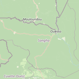
Map view of Nouabalé-Ndoki National Park

Use this park location map to pinpoint Nouabalé-Ndoki National Park in Congo, understand its exact geographic position, and read its mapped placement within the surrounding landscape more clearly.

Pigeon | © OpenStreetMap contributors

Location context for Nouabalé-Ndoki National Park

Likouala DepartmentSangha Department
Park atlas

Uncover contiguous protected landscapes and park geography across the Congo Basin, including transboundary regions like the Sangha Trinational

Compare Other National Parks and Protected Areas Near Nouabalé-Ndoki National Park
After viewing Nouabalé-Ndoki National Park, explore additional protected areas and national parks throughout the broader Congo Basin and its interconnected Central African regions. Compare diverse conservation landscapes, trace regional protection efforts, and map the spread of unique ecosystems within the Republic of Congo and neighboring nations.
Watercolor painting showing rolling hills, green vegetation, and a pinkish river area
National parkCentral African Republic

Dzanga-Ndoki National Park National Park: Mapped Boundaries and Geographic Context in Central Africa

Explore protected landscape geography and park atlas details.

Gain a structured understanding of Dzanga-Ndoki National Park as a protected area in the Central African Republic. This page focuses on its precise geographic scope, mapped park boundaries, and its identity as a National Park. It serves as an entry point for exploring the park's landscape context and its place within the atlas of protected natural areas, offering factual details for geographic discovery.

Area
1,143.26 km²
Established
1990
IUCN
II
Relief
Lowland
National park

Lobéké National Park National Park: A Protected Landscape within the Congo Basin

Explore its semi-evergreen forest, unique bais, and riverine ecosystems.

Lobéké National Park represents a core protected national park within the vast Congo Basin, renowned for its exceptionally high densities of African forest elephants and western lowland gorillas. Covering over 2,000 square kilometers of largely untouched semi-evergreen forest, the park features distinct ecosystems including mineral-rich bais clearings, saline swamp savannas, and diverse riverine habitats. As a crucial component of the Sangha Trinational protected area, Lobéké National Park offers a profound look into Central African wilderness and its unique natural geography.

Area
2,178 km²
Established
1999
IUCN
II
Relief
Lowland
National parkEast Province

Boumba Bek National Park: National Park with Protected Landscape Identity in East Province

Explore its geographic context and mapped protected boundaries.

Boumba Bek National Park is a key protected area within Cameroon's East Province, offering a dedicated focus for understanding national park landscapes. This resource facilitates discovery of its precise geographic footprint and its significance as a mapped protected land. Users can delve into its regional context and explore the atlas-level details defining its protected status and natural landscape character.

Area
2,382 km²
Established
2005
IUCN
II
Relief
Lowland
National parkCameroon

Nki National Park: Protected National Park Landscape in Cameroon

Explore the geographic context and mapped boundaries.

Nki National Park is a designated national park in Cameroon, offering a distinct protected landscape for geographic study. This page provides essential context for understanding the park's place within the country's natural geography and protected areas atlas. Explore its mapped terrain and protected boundary details to gain a clearer picture of this natural entity within Central Africa's diverse geography.

Area
3,093 km²
Established
2005
IUCN
II
Relief
Upland
National parkCongo

Ntokou-Pikounda National Park: Congo's Protected Landscape and Regional Geographic Atlas

Explore the mapped boundaries of this national park in Congo.

Ntokou-Pikounda National Park serves as a critical point of reference for understanding protected landscapes in Congo. As a national park, its geographic scope and mapped boundaries are essential for atlas-based discovery. This detailed entry facilitates an exploration of its protected terrain and regional context, highlighting its significance within the broader conservation geography.

Area
4,572 km²
Established
2012
IUCN
II
Relief
Lowland
National parkCuvette-Ouest Department

Odzala-Kokoua National Park National Park: Mapped Protected Landscape in Cuvette-Ouest

Explore its geographic boundaries and regional terrain.

Odzala-Kokoua National Park is a key national park entity, offering a distinct protected landscape within the Cuvette-Ouest Department. This page provides an atlas-style exploration of its mapped boundaries and geographic context. Delve into the specifics of this protected area to understand its contribution to the regional geography and natural landscape, facilitating structured discovery of its terrain.

Area
13,500 km²
Established
1935
IUCN
II
Visitors
50 annual
National parkGabon

Minkébé National Park: Protected Area and Geographic Context in Gabon

Explore the mapped terrain and protected landscape of this national park.

Gain a structured understanding of Minkébé National Park, a designated national park situated in Gabon. This destination focuses on the park's protected landscape, its distinct mapped boundaries, and its contribution to the regional geography of Central Africa. Examine how its protected status shapes the natural terrain and offers a unique angle for geographic discovery.

Area
7,570 km²
Established
2002
IUCN
II
Relief
Upland
National park

Deng Deng National Park: Protected Landscape & Gorilla Habitat in East Cameroon

Discover the mapped geography and conservation significance of this national park.

Deng Deng National Park in Cameroon's East Region offers a unique glimpse into the Northern Congolian forest-savanna mosaic ecoregion. Spanning about 683 square kilometers and shaped by the Sanaga River, it is critically important as the northernmost known habitat for western lowland gorillas. Its diverse terrain supports not only gorillas but also elephants, chimpanzees, and pangolins, highlighting its role in Central African biodiversity and regional landscape context.

Area
682.64 km²
Established
2010
IUCN
II
Climate
Tropical

Common questions about visiting, size, designation, and location context for Nouabalé-Ndoki National Park

Nouabalé-Ndoki National Park FAQs for park facts, access, geography, and protected area context
Find quick answers about Nouabalé-Ndoki National Park, including protected-area facts, park geography, trail and visitor context, and how the park fits into its surrounding country and regional landscape.
MoriAtlas Explorer

Continue Your Protected Areas Search Across the Global Atlas

Deepen your exploration by continuing the structured search for national parks and protected areas worldwide. Utilize the comprehensive filtering capabilities to compare different conservation landscapes and refine your understanding of global park geography. Discover more about the distribution and characteristics of protected natural areas.

Global natural geography


