

Mori Atlas logo
Nature reserveNuminbah Nature Reserve

A sanctuary of volcanic escarpments, ancient Antarctic beech, and sheltered subtropical creek lines

Numinbah Nature Reserve: Mapping Protected Rainforest Landscapes in the Border Ranges of New South Wales

Numinbah Nature Reserve serves as a critical protected landscape within the Border Ranges of New South Wales. This reserve encompasses a dramatic volcanic escarpment rising over one thousand metres, transitioning from rhyolite cliffs to basalt-enriched rainforest shelves. The area functions as a vital conservation block within the Gondwana Rainforests of Australia, protecting rare species such as the northernmost natural occurrences of Antarctic beech along its misty creek systems.

strict nature reservesubtropical rainforestAntarctic beechBorder Rangescaldera landscapeGondwana rainforests

Numinbah Nature Reserve

Nature reserve

Park overview

Structured park overview, official facts, and landscape profile for Numinbah Nature Reserve

Numinbah Nature Reserve park facts, protected area profile, and essential visitor context

Review the core facts for Numinbah Nature Reserve, including designation, size, terrain, visitor scale, habitats, and operating context in one park-focused overview.

About Numinbah Nature Reserve

Numinbah Nature Reserve is a strict nature reserve in the Northern Rivers region of New South Wales, occupying a steep and ecologically rich slice of the Border Ranges where the states of New South Wales and Queensland meet. Though compact at 858 hectares, the reserve captures a representative cross-section of one of eastern Australia's most significant upland rainforest landscapes, descending from a high rhyolite escarpment down into deeply forested creek valleys.

The reserve is set within the Mount Warning and Tweed River caldera, the eroded remains of a massive ancient shield volcano whose rim forms the dramatic ranges and escarpments around the surrounding region. This geological context gives Numinbah its distinctive combination of rhyolite cliffs, basalt-influenced soils on the lower shelf, and the high-rainfall, mist-prone conditions that support cool temperate rainforest stands at elevation and lush subtropical rainforest below.

Ecologically, Numinbah is a stronghold for Gondwanan plant lineages. Its small stand of Antarctic beech is among the most celebrated and most northerly natural occurrences in Australia, while forests of black booyong, purple cherry, red lilly pilly, rose marara, and black bean include record-sized specimens documented by the rainforest botanist A. G. Floyd. The reserve is also designated as part of the Scenic Rim Important Bird Area for the conservation of threatened bird species, reinforcing its importance well beyond its modest footprint.

The reserve is managed to allow its flora and fauna to develop free of interference from humans, domestic animals, and feral pests, which is reflected in its IUCN Category Ia strict nature reserve status. The southern boundary adjoins private landholdings, but the core reserve remains a tightly protected ecological refuge within a larger trans-boundary conservation landscape.

Quick facts and research context for Numinbah Nature Reserve

Numinbah Nature Reserve is an IUCN Category Ia strict nature reserve in northeastern New South Wales, gazetted in December 1981 and expanded in 1989 to its present area of 858 hectares. It is administered by the NSW National Parks and Wildlife Service and sits in the Border Ranges, southeast of the rural locality of Numinbah and south of Springbrook in Queensland.

The reserve is part of the Mount Warning/Tweed caldera system and falls within the Gondwana Rainforests of Australia UNESCO World Heritage Area, which was inscribed in 1986 and added to the Australian National Heritage List in 2007. It also lies within the Scenic Rim Important Bird Area, recognized by BirdLife International for its importance to threatened bird species.

The landscape is dominated by an escarpment rising over one thousand metres above sea level, with vegetation ranging from subtropical rainforest at lower elevations to cool temperate rainforest patches above, including a notable stand of Antarctic beech at Best-of-all Lookout near the state border.

Protection and recognition

Terrestrial protected area records and official conservation status details.

Numinbah Nature Reserve Protection Status and Territorial Designation

Numinbah Nature Reserve preserves documented terrestrial protection status and management scope details within the global conservation registry. Official administrative records outline the governance framework and recognition history associated with this protected landscape.

Protection details

Protection scope
Terrestrial
Transboundary protection
No
Park context

Deeper park guide and search-rich context for Numinbah Nature Reserve

Numinbah Nature Reserve history, landscape, wildlife, and travel context

Explore Numinbah Nature Reserve through its history, landscape character, ecosystems, wildlife, conservation priorities, cultural context, and seasonal travel timing in a structured park guide built for atlas discovery and search intent.

Why Numinbah Nature Reserve stands out

Numinbah is best known for hosting one of the northernmost natural occurrences of the Antarctic beech (Nothofagus moorei) in Australia, including very old, gnarled specimens with stems arising from massive above-ground roots. A frequently photographed triple-stemmed individual sits near the New South Wales and Queensland border and is believed to be of great age. The reserve is also distinguished by the quality of its subtropical rainforest on the basalt-enriched shelf beneath the rhyolite cliffs, which is regarded as outstanding among Australian rainforests. It sits within the Gondwana Rainforests of Australia World Heritage Area and the Scenic Rim Important Bird Area, making it a small but unusually significant reserve in a broader conservation landscape.
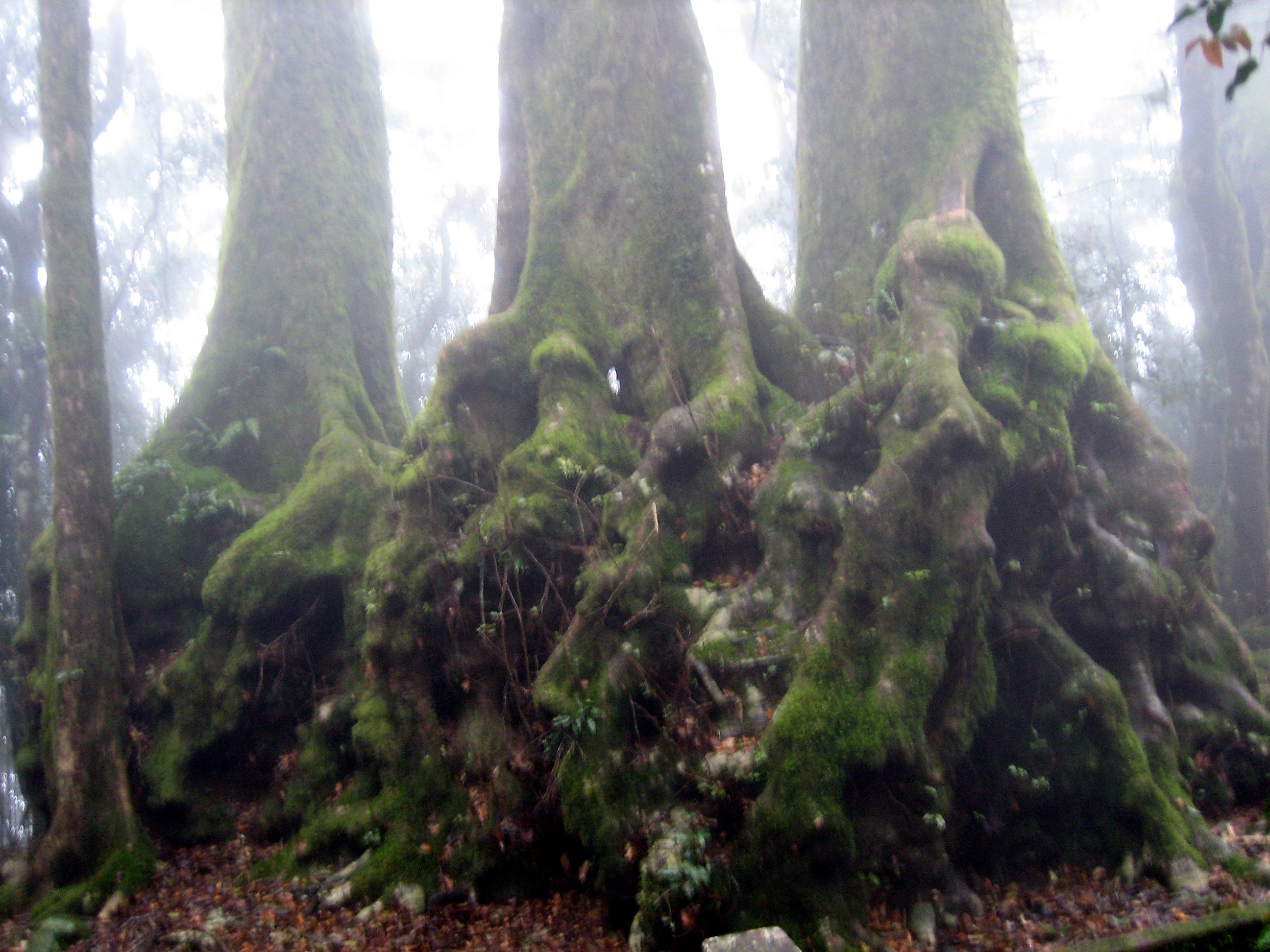
Close-up view of the thick, buttressed base of several large trees, covered in thick green moss, situated in a dense, misty forest.
The buttressed, mossy base of an ancient Antarctic Beech tree in the misty Numinbah Nature Reserve.

Numinbah Nature Reserve history and protected-area timeline

Numinbah Nature Reserve was gazetted as a protected nature reserve in December 1981 under the administration of what is now the NSW National Parks and Wildlife Service. In 1989, a further addition expanded the reserve to its current size of 858 hectares, consolidating the protected footprint around the escarpment and rainforest stands near the New South Wales–Queensland border.

The reserve's longer significance is tied to broader regional and international conservation milestones. In 1986, the Australian rainforests that include this landscape were inscribed as the Gondwana Rainforests UNESCO World Heritage Site, recognizing the area's exceptional concentration of ancient plant lineages. The Australian National Heritage List added the Gondwana Rainforests in 2007, further formalizing their national and global conservation importance. Within this framework, Numinbah contributes a strict-reserve core where natural processes are intended to operate with minimal human interference.

The reserve also became part of the Scenic Rim Important Bird Area, identified by BirdLife International for the conservation of threatened bird species reliant on the upland rainforests of the region. Together these designations situate Numinbah's relatively short formal protection history within a much larger, layered story of recognition for the Border Ranges' natural values.

Numinbah Nature Reserve landscape and geographic character

The landscape of Numinbah Nature Reserve is defined by a dramatic escarpment that rises to over one thousand metres above sea level, forming part of the natural border between New South Wales and Queensland. The cliffs and upper slopes are composed of rhyolite, the volcanic rock that gives the Border Ranges much of their character, while a lower shelf below the Springbrook plateau carries soils enriched with basalt, creating particularly fertile ground for tall rainforest species.

Below the cliffs, deeply incised creek systems including Pat Smiths Creek, Crystal Creek, and Couchy Creek drain the reserve, their sheltered heads supporting some of the most impressive rainforest stands in the area. Massive fallen rhyolite blocks lie scattered along the forest floor near these creeks, and unusually tall trees grow beside them in the enriched, sheltered conditions. The combination of high rainfall, frequent mist, steep topography, and ancient volcanic geology creates a layered tropical-to-temperate environment compressed into a small area.

Numinbah Nature Reserve ecosystems, habitats, and plant life

The vegetation of Numinbah Nature Reserve is dominated by subtropical rainforest, with patches of wet sclerophyll forest and a small but ecologically priceless area of cool temperate rainforest at higher elevation. The canopy and understorey are characteristic of the Border Ranges rainforests, featuring emergent species such as black booyong, purple cherry, red lilly pilly, rose marara, and black bean, several of which attain record sizes documented by the rainforest botanist A. G. Floyd.

A particular feature of the reserve is the occurrence of the rare Springbrook leatherwood (Eucryphia jinksii) alongside the more celebrated stand of Antarctic beech. The Antarctic beech population here, found within a roughly one-hectare area embedded in a 2.9-hectare cool temperate stand near Best-of-all Lookout, sits at the northernmost limit of the species' natural distribution in Australia, adding strong biogeographical interest to the reserve's flora.

The rainforest at the base of the rhyolite cliffs is regarded as outstanding among Australian rainforests, with many rare plant species present alongside climbing plants recorded at unusual diameters of around one metre. The combination of high rainfall and frequent mist produces the persistent humidity and shelter that allows these Gondwanan plant communities to persist in a landscape otherwise exposed to subtropical conditions.

Numinbah Nature Reserve wildlife and species highlights

While the reserve is primarily valued for its vegetation, its wildlife significance is embedded in its broader landscape context. Numinbah lies within the Scenic Rim Important Bird Area, recognized by BirdLife International because of the area's importance for several threatened bird species that depend on the upland rainforests of the Border Ranges. The intact canopy cover, deep leaf litter, and connectivity with surrounding forest give the reserve value as habitat for forest-dependent bird species and other native fauna associated with Gondwanan rainforest.

As a strict nature reserve, the area is specifically managed to allow its flora and fauna to develop free from interference by humans, domestic animals, and feral pests, which supports more natural wildlife patterns than in many other parts of the region. The dense subtropical and temperate rainforests, combined with cliffs, creek lines, and misty high-elevation forest patches, create a mosaic of microhabitats typical of the Border Ranges. Detailed lists of mammal, reptile, and invertebrate species are not prominent in readily available sources, so the wildlife profile is best understood in terms of its habitat value rather than as a species inventory.

Numinbah Nature Reserve conservation status and protection priorities

Numinbah Nature Reserve holds a particularly strong conservation profile relative to its small size. It is classified as an IUCN Category Ia strict nature reserve, the category reserved for areas managed primarily for scientific research and ecosystem protection, with strict controls on human access and intervention. This status reflects an intent to allow the reserve's flora and fauna to function with minimal interference from humans, domestic animals, and feral pests.

At a broader scale, the reserve is a component of the Gondwana Rainforests of Australia UNESCO World Heritage Site, inscribed in 1986 and added to the Australian National Heritage List in 2007. This places Numinbah within one of the most globally significant concentrations of ancient rainforest in the southern hemisphere, protecting lineages with direct evolutionary connections to the forests of Gondwana.

The reserve also falls within the Scenic Rim Important Bird Area, a designation from BirdLife International that recognizes the Border Ranges as a priority site for the conservation of threatened bird species. Together, these overlapping layers of protection, strict nature reserve status, World Heritage inscription, national heritage listing, and Important Bird Area designation, give Numinbah a disproportionately high conservation profile for an area of just 858 hectares.

Numinbah Nature Reserve cultural meaning and human context

The Numinbah area lies within a broader Border Ranges landscape that holds deep significance for Traditional Owners, whose ongoing connections to Country in the ranges around the New South Wales–Queensland border encompass the forests, escarpments, and waterways that Numinbah helps protect. Available English-language sources do not provide detailed accounts of specific cultural practices, sites, or stories associated with the reserve itself, so this dimension is best acknowledged as part of the wider regional context rather than as a documented feature of the reserve.

The reserve's identity is also shaped by modern conservation culture, including the longstanding fieldwork of the rainforest botanist A. G. Floyd, whose records of unusually large and rare trees here contributed to broader recognition of the Border Ranges as a place of exceptional botanical significance. Popular cultural references, including the frequently photographed triple-stemmed Antarctic beech near the state border, have made this small reserve a recognizable landmark within Australia's rainforest heritage landscape.

Top sights and standout views in Numinbah Nature Reserve

A compact reserve with an outsized ecological profile, Numinbah combines an over-one-thousand-metre escarpment, rhyolite cliffs, basalt-enriched rainforest soils, and sheltered creeks into a single protected block near the New South Wales–Queensland border.

Its highlights include a celebrated stand of Antarctic beech at the northern edge of the species' range, the presence of the rare Springbrook leatherwood, record-sized specimens of black booyong, purple cherry, red lilly pilly, rose marara, and black bean, and layered designations as a strict nature reserve, part of the Gondwana Rainforests World Heritage Area, and a component of the Scenic Rim Important Bird Area.

Best time to visit Numinbah Nature Reserve

Numinbah Nature Reserve sits in a high rainfall zone with frequent mist, conditions that shape the experience of the forest in any season. Cooler, drier periods tend to make the steep walking tracks more comfortable and may improve views from the escarpment edge, while warmer, wetter months intensify the lushness of the rainforest and the volume of the creeks. The Antarctic beech stand near Best-of-all Lookout draws visitors year-round, its misty, moss-rich atmosphere most atmospheric in cooler months and after rainfall, while bird activity across the Scenic Rim Important Bird Area can be rewarding across multiple seasons. Because the reserve is managed as a strict nature reserve, visitors typically access it via short walks from surrounding lookouts rather than through in-depth visitor facilities.

Monthly climate preview

Long-term monthly temperature and precipitation data recorded at representative coordinates

Numinbah Nature Reserve Climate Normals and Annual Temperature Patterns

Numinbah Nature Reserve exhibits a measured annual temperature and precipitation rhythm spanning long-term averages from 1991 to 2020. Reviewing the complete twelve-month dataset provides a detailed baseline of monthly temperature variations and precipitation volumes.
Annual mean20 °C
14 °C25 °C
Jan25°
Feb24°
Mar23°
Apr21°
May18°
Jun15°
Jul14°
Aug15°
Sep18°
Oct21°
Nov23°
Dec24°
Warmest month
January

24.9 °C

Coolest month
July

14.4 °C

Wettest month
February

5.8 mm/day

Driest month
September

1.3 mm/day

Park location guide

Geography guide, regional context, and park location map for Numinbah Nature Reserve

Numinbah Nature Reserve park geography, regions, and map view in Australia

Understand where Numinbah Nature Reserve sits in Australia through a broader geographic reading of the surrounding landscape, nearby location context, and its mapped position within the national park landscape.

How Numinbah Nature Reserve fits into Australia

Australia is a constitutional monarchy and federal parliamentary democracy comprising six states and ten territories. With a population of nearly 28 million, it is one of the world's most urbanised countries, with most people concentrated on the eastern seaboard. The country has a high Human Development Index and is known for its cultural diversity, ancient Aboriginal heritage, and unique wildlife.

Wider geography shaping Numinbah Nature Reserve in Australia

Australia occupies the entire Australian continent, the island of Tasmania, and numerous smaller islands. It is the world's flattest and driest inhabited continent, featuring vast deserts in the interior (the Outback), tropical rainforests along the eastern coast, and a coastline bordering the Indian and Pacific Oceans.

Map view of Numinbah Nature Reserve

Use this park location map to pinpoint Numinbah Nature Reserve in Australia, understand its exact geographic position, and read its mapped placement within the surrounding landscape more clearly.

Pigeon | © OpenStreetMap contributors

Location context for Numinbah Nature Reserve

New South Wales

Visual reference for volcanic escarpments, ancient rainforest habitats, and protected terrain.

Numinbah Nature Reserve Photos and Mapped Landscape Scenery

Visual documentation captures the dramatic volcanic escarpments and subtropical rainforest habitats defining Numinbah Nature Reserve. Photographic records reveal the sheltered creek lines, ancient Antarctic beech stands, and basalt-enriched terrain that characterize this protected area.

Close-up view of the thick, buttressed base of several large trees, covered in thick green moss, situated in a dense, misty forest.

Park atlas

Compare regional volcanic landscapes and connected conservation reserves

Explore Parks Near Numinbah Nature Reserve and Surrounding Protected Areas

Discover protected areas near Numinbah Nature Reserve to examine neighboring rainforest habitats and volcanic escarpments across the regional border. Comparing adjacent conservation lands reveals broader ecological patterns within the ancient caldera landscape and surrounding mountain ranges.
National parkQueensland
About 0.6 km away#1 closest

North

Springbrook National Park National Park: Exploring Queensland's Protected Landscape Atlas

Mapped boundaries and regional geographic context for this Australian national park.

Springbrook National Park serves as a vital entry for understanding protected landscapes within Queensland, Australia. As a national park, it offers a distinct geographic profile, contributing to the broader atlas of conservation areas in northeastern Australia. Users can explore its specific mapped boundaries and appreciate its role in the regional geography, providing a factual basis for understanding the distribution and character of Australia's natural parklands.

Area
61.56 km²
Established
1990
IUCN
II
Relief
Mountain
Nature reserveNew South Wales
About 2.7 km away#2 closest

South

Couchy Creek Nature Reserve: Mapped Protected Landscapes in New South Wales

Subtropical forest remnants and vegetation corridors

Couchy Creek Nature Reserve protects a 217 hectare mosaic of lowland rainforest and wet sclerophyll forest. Situated in the Northern Rivers of New South Wales, the reserve forms an essential refuge for threatened plant species and maintains critical ecological connectivity across a heavily modified agricultural region.

Area
2.17 km²
Established
1999
IUCN
Ia
Relief
Upland
National parkQueensland
About 4 km away#3 closest

Northwest

Lamington National Park: Ancient Gondwanan Rainforests and Volcanic Terrain in Queensland

Mapped protected landscape with over 500 waterfalls and unique cloud forests.

Lamington National Park stands as a key protected area within Queensland, recognized for its world-heritage status Gondwanan rainforests and striking volcanic geography. The park's landscape is characterized by its ancient Antarctic beech forests, a legacy of millions of years of volcanic activity that sculpted dramatic cliffs, plateaus, and deep valleys, punctuated by more than 500 waterfalls. Through its mapped boundaries and detailed geographic context, users can explore the exceptional biodiversity and unique terrain that defines this significant Australian national park.

Area
206 km²
Established
1915
IUCN
II
Visitors
1.2M annual
Nature reserveNew South Wales
About 11 km away#4 closest

Southwest

Limpinwood Nature Reserve: Old-Growth Rainforest and Escarpment Landscapes in New South Wales

A protected subtropical wilderness sanctuary on the McPherson Range

Limpinwood Nature Reserve protects a vast extent of old-growth subtropical rainforest in far north-eastern New South Wales. Characterized by steep escarpment terrain and continuous forest canopy, this wilderness area serves as a critical refuge for biodiversity and is recognized as part of the Gondwana Rainforests of Australia, maintaining a strict low-intervention approach to conservation.

Area
26.46 km²
Established
1963
IUCN
Ib
Relief
Mountain
National parkQueensland
About 12 km away#5 closest

Northeast

Nicoll Scrub National Park: Queensland National Park Geography and Landscape

Explore the mapped boundaries and regional context of this protected area.

Nicoll Scrub National Park is a designated national park contributing to the rich protected landscape tapestry of Queensland, Australia. This entry provides detailed information focused on its geographic identity, allowing for atlas-style exploration of its mapped boundaries and its role within the state's natural geography. Understand the specific context of this park as a protected natural area.

Area
0.27 km²
Established
1986
IUCN
II
Relief
Mountain
National parkAustralia
About 14 km away#6 closest

Southwest

Border Ranges National Park: A Key Protected Landscape in Australian Geography

Explore its mapped boundaries and regional terrain.

Border Ranges National Park represents an important national park entity within Australia. This page facilitates detailed exploration of the park's protected landscape, its surrounding geography, and its specific place within the broader Australian atlas. Engage with the mapped terrain and understand the distinct regional context that defines this protected natural area.

Area
317.29 km²
Established
1979
IUCN
II
Relief
Mountain
National parkNew South Wales
About 15 km away#7 closest

South

Wollumbin National Park: Protected Landscape Atlas and Geographic Context

Explore New South Wales's protected area boundaries.

Delve into the specifics of Wollumbin National Park, a designated national park situated in New South Wales. This entry focuses on its protected landscape identity, mapping its geographic boundaries and regional context for dedicated atlas exploration. Understand how Wollumbin National Park fits into the larger mosaic of Australia's protected areas.

Area
24 km²
Established
1967
IUCN
II
Relief
Mountain
National parkNew South Wales
About 20 km away#8 closest

Southwest

Mebbin National Park National Park: Protected Landscape Atlas and Regional Geography

Explore mapped park boundaries and natural terrain in New South Wales.

Mebbin National Park represents a vital national park entity, offering rich geographic context for structured discovery. Users can investigate its protected landscape characteristics and mapped boundaries within New South Wales. This park's unique natural terrain and regional setting are essential for understanding its place in the Australian conservation atlas, providing detailed insights for geographic exploration and mapped landscape analysis.

Area
38 km²
IUCN
II
Relief
Mountain
Climate
Subtropical

Common questions about visiting, size, designation, and location context for Numinbah Nature Reserve

Numinbah Nature Reserve FAQs for park facts, access, geography, and protected area context

Find quick answers about Numinbah Nature Reserve, including protected-area facts, park geography, trail and visitor context, and how the park fits into its surrounding country and regional landscape.
MoriAtlas Explorer

Continue Your Protected Areas Search Across the Global Atlas

Deepen your exploration by continuing the structured search for national parks and protected areas worldwide. Utilize the comprehensive filtering capabilities to compare different conservation landscapes and refine your understanding of global park geography. Discover more about the distribution and characteristics of protected natural areas.

Global natural geography