
Mori Atlas logo
Protected areaÖgii Lake

Analyzing the ecological boundaries and landscape characteristics of this high-steppe wetland

Ögii Lake Protected Area: Mapping the Freshwater Steppe Ecosystem of Arkhangai Province

(Ogii Nuur Ramsar Site)

Ögii Lake sits within a broad basin of the central Mongolian steppe, characterized by its shallow margins and expansive shoreline. As an internationally recognized Ramsar wetland and Important Bird Area, it functions as a primary migratory stopover for Anatidae species. The surrounding geography transitions from flat grasslands to the forested uplands of the Khangai region, creating a distinctive high-elevation aquatic landscape.

freshwater lakesteppe wetlandRamsar siteImportant Bird Areamigratory waterbirdsAnatidae
A flat-style digital illustration depicting a wide mountain valley with a winding river, evergreen forest, and a waterfall, rendered in a soft pastel color palette.

Ögii Lake

Protected area

Park overview

Structured park overview, official facts, and landscape profile for Ögii Lake

Ögii Lake park facts, protected area profile, and essential visitor context

Review the core facts for Ögii Lake, including designation, size, terrain, visitor scale, habitats, and operating context in one park-focused overview.

About Ögii Lake

Ögii Lake is a significant freshwater lake in north-central Mongolia, located in Arkhangai Province within the broader steppe landscape that characterize this part of the country. The lake lies in the Ögii nuur district and represents a typical example of a steppe freshwater lake: relatively shallow, highly productive in terms of aquatic life, and surrounded by open grasslands used by nomadic herders for centuries. Its setting on the northern edge of the central Mongolian steppe gives it a transitional feel, with the high plains to the north and the more elevated, partly forested terrain of the Khangai region to the west and south.

The lake covers a surface area of around 25.7 square kilometers and reaches a maximum depth of 15.3 meters, although roughly half of the lake is shallower than three meters. This shallow profile and extensive shoreline are central to its ecological importance, since the gently sloping margins provide extensive feeding habitat for waterbirds. The shoreline stretches for about 24.7 kilometers around the lake, creating a long interface between open water and steppe vegetation. This mosaic of habitats is exactly what makes the area attractive to migratory Anatidae and other waterbirds that rely on predictable, productive stopover sites during their seasonal journeys.

Ögii Lake is valued for more than its scenery. It has been recognized under the Ramsar Convention as a Wetland of International Importance, designated in 1998 under the official name Ogii Nuur, reflecting its standing in international wetland conservation. BirdLife International has separately listed it as an Important Bird Area, primarily because of its role in supporting migratory waterbirds. The lake is also a working fishery, and its fish resources have long supported local communities. A habitat study of the lake and its surroundings was conducted in 2005 and 2006, contributing to a formal designation of the area as a protected area from 2006 onward. Today, the combination of ecological, conservation, and livelihood values makes Ögii Lake an important example of Mongolia's freshwater resources and a key site for understanding steppe wetland conservation.

Quick facts and research context for Ögii Lake

Ögii Lake is a freshwater lake in Arkhangai Province, Mongolia, covering roughly 25.7 square kilometers and reaching a maximum depth of about 15 meters, with much of the lakebed being notably shallow. It sits at approximately 1,337 meters above sea level, giving it a high-steppe setting characteristic of central Mongolia. The lake was designated a Ramsar Wetland of International Importance in 1998 under the name Ogii Nuur and is recognized by BirdLife International as an Important Bird Area for migratory waterbirds. It is also a working fishery and a stopover on broader flyway routes used by migratory Anatidae.

Protection and recognition

Documented terrestrial protection history, designation year, and management scope

Ögii Lake Protection Status and International Recognition Records

Terrestrial protection status records for Ögii Lake outline the established 1998 designation framework and management scope. Structured records assemble verified conservation timelines, administrative classifications, and international recognition data for the protected area.

Protection details

Protection scope
Terrestrial
Designated year
1998
Transboundary protection
No
Park context

Deeper park guide and search-rich context for Ögii Lake

Ögii Lake history, landscape, wildlife, and travel context

Explore Ögii Lake through its history, landscape character, ecosystems, wildlife, conservation priorities, cultural context, and seasonal travel timing in a structured park guide built for atlas discovery and search intent.

Why Ögii Lake stands out

Ögii Lake is best known as an internationally recognized wetland habitat in the Mongolian steppe. Its shallow freshwater basin and rich aquatic productivity attract migratory waterbirds, particularly Anatidae species such as ducks, geese, and swans, making it a key stopover point along the Central Asian flyway. Equally important is the lake's role as a Ramsar Site of International Importance. This designation reflects not only its birdlife but also the broader wetland values of the site, including its open water, shallow margins, and the surrounding steppe habitats that together support a diverse aquatic and semi-aquatic ecosystem in a region where freshwater habitat is limited.
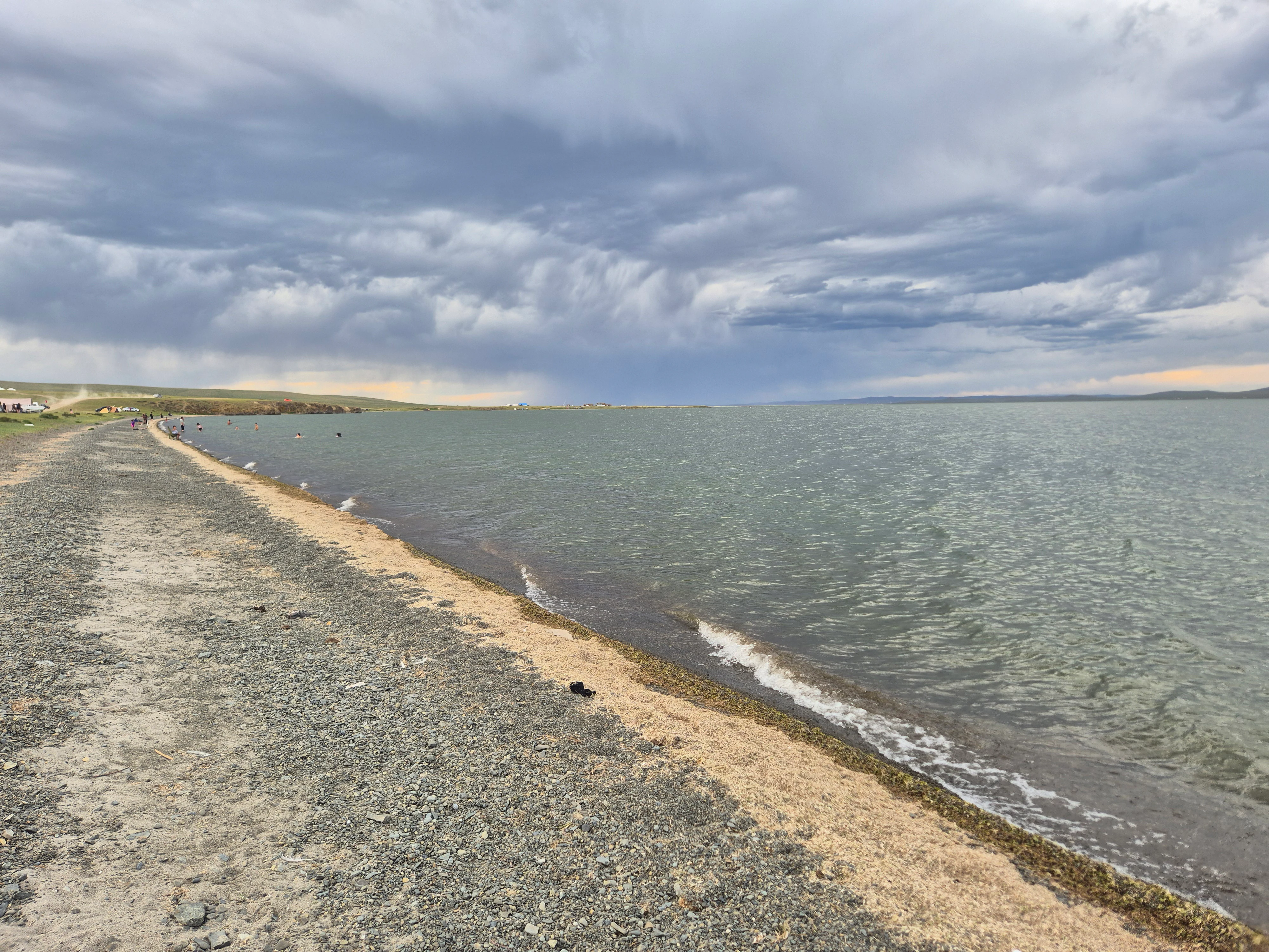
A wide, low-angle shot of the gravelly shoreline of a large, calm lake under a heavy, grey, cloudy sky in Mongolia.
The pebble-strewn shoreline of Ögii Lake under a dramatic, cloud-filled sky.

Ögii Lake history and protected-area timeline

The conservation history of Ögii Lake reflects growing international attention to Mongolia's steppe wetlands. Its first major international recognition came in 1998, when the lake was formally designated under the Ramsar Convention as a Wetland of International Importance under the official name Ogii Nuur.

A key turning point for national-level protection came in the mid-2000s. In 2005 and 2006, researchers conducted a study of the lake and its surrounding habitats to better understand the area's ecological character and the total extent of habitat available to waterbirds and other wildlife. The findings from this work contributed to a formal decision to designate Ögii Lake as a protected area beginning in 2006. This status reinforced its existing Ramsar recognition and provided a stronger framework for managing the lake's ecological values alongside its continued role as a local fishery.

Beyond formal designations, the lake has long been part of the daily life of the surrounding herding communities, who have used its fish resources and its shoreline pastures for generations. Today, the lake's history is increasingly framed around the need to balance traditional use, sustainable fisheries, and ecological protection for migratory waterbirds.

Ögii Lake landscape and geographic character

Ögii Lake occupies a broad, open basin within the central Mongolian steppe. The lake itself is relatively large in surface area but shallow overall, with a maximum depth of just over 15 meters and large portions of the basin less than three meters deep. This gently sloping underwater profile creates extensive shallow margins, which influence both the ecology of the lake and the way its shoreline blends into the surrounding land.

The wider landscape is defined by steppe. Flat and rolling grasslands extend around much of the lake, punctuated by the long, roughly 25-kilometer shoreline that traces the edge of the water. To the west and south, the terrain becomes more elevated as the steppe transitions toward the Khangai uplands, where forested slopes contrast with the open plains. The lake's elevation of about 1,337 meters places it firmly within the high-steppe zone, contributing to a climate of long cold winters, short warm summers, and significant seasonal variation in water levels and ice cover.

Together, the lake's shallow profile, expansive shoreline, and setting amid open steppe and distant forested hills create a landscape that is at once broad and intimate: large enough to feel open and wild, but ecologically structured around the interaction of water, shore, and grassland.

Ögii Lake ecosystems, habitats, and plant life

As a freshwater steppe lake, Ögii Lake belongs to a specific ecological category that is relatively rare across the wide, semi-arid grasslands of central Asia. Its ecological character is shaped by the combination of open water, shallow margins, fringing wetlands, and surrounding steppe vegetation, forming a mosaic that supports both aquatic and terrestrial species.

The lake's shallow profile means that much of its water volume occurs across broad, sunlit areas, encouraging high biological productivity. Aquatic vegetation can establish along the gently sloping shoreline, and the margins of the lake provide important feeding and resting habitat for waterbirds. The surrounding steppe adds a terrestrial dimension, offering habitat for steppe-adapted species of plants, insects, and ground-nesting birds. The result is a wetland ecosystem that is not only defined by the lake itself, but by the broader interaction between water and steppe.

The continental climate adds an important rhythm to the ecosystem. Seasonal changes in temperature, ice cover, and water levels strongly influence when and how the lake can support wildlife, and the strongest ecological activity typically aligns with spring and autumn migration periods and the open-water season.

Ögii Lake wildlife and species highlights

Ögii Lake is primarily recognized for its birdlife, particularly its role as a stopover for migratory waterbirds. The lake's main claim to fame within the conservation community is its importance for the family Anatidae, which includes ducks, geese, and swans. These species rely on predictable, productive freshwater sites during migration, and Ögii Lake's shallow waters and extensive shoreline make it a particularly valuable resting and feeding area.

Beyond migrating waterfowl, the lake and its margins attract a range of other waterbirds, including wading species and shorebirds that use the fringing shallows and emergent vegetation. The surrounding steppe supports additional wildlife typical of central Mongolia, including ground-nesting birds and the broader community of steppe fauna adapted to the region's continental climate.

Fish are another important component of the lake's wildlife. Ögii Lake supports a local fishery, reflecting the productivity of its waters, and fish play a role both in the local economy and in the broader aquatic food web that sustains the lake's birdlife.

Ögii Lake conservation status and protection priorities

Conservation at Ögii Lake operates on multiple, overlapping levels. The lake was designated a Ramsar Wetland of International Importance in 1998 under the official name Ogii Nuur, recognizing its significant ecological values at the global level. BirdLife International has separately designated the site as an Important Bird Area, focusing on its importance for migratory waterbirds, particularly members of the Anatidae family.

At the national level, the lake became a formally protected area from 2006, following ecological surveys of the lake and its surrounding habitat conducted in 2005 and 2006. This national protection reinforced the international designations and provided a framework for managing the lake's ecosystems, its shoreline, and the surrounding steppe habitats in an integrated way.

The conservation significance of Ögii Lake lies in the combination of these layers of recognition. It is a rare example of a steppe freshwater lake that simultaneously meets Ramsar criteria for wetland importance, qualifies as an Important Bird Area for migratory species, and has been integrated into Mongolia's national protected-area system. The lake's ongoing role as a working fishery adds an extra dimension, raising the need to balance human use and ecological protection in the long term.

Ögii Lake cultural meaning and human context

Ögii Lake has long been part of the cultural and economic life of the surrounding region. Although the source material does not provide extensive detail on indigenous traditions, the lake's role as a working fishery and the presence of ger tourist camps and local information centers around its shoreline suggest that it remains closely tied to the livelihoods of local communities.

The broader cultural pattern in this part of Mongolia involves nomadic and semi-nomadic herding traditions, where lakes and rivers serve as focal points within wide grazing territories. For many herding families in the Ögii nuur district, the lake has likely been a familiar reference point in seasonal movement, providing both fish and a reliable water source across generations.

Top sights and standout views in Ögii Lake

Ögii Lake's standout features include its status as a Ramsar Wetland of International Importance, its recognition as an Important Bird Area, and its role as a major stopover for migratory Anatidae in central Mongolia. The lake's shallow profile, long shoreline, and setting amid the northern Mongolian steppe make it ecologically distinctive within a region where productive freshwater habitat is relatively limited.

Equally distinctive is the way the site combines international conservation recognition, national protected-area status since 2006, and an active local fishery. This integration of ecological values and human use makes Ögii Lake an important example of how steppe wetlands can be managed as living, working landscapes rather than purely protected enclaves.

Best time to visit Ögii Lake

The most ecologically meaningful periods around Ögii Lake are spring and autumn, when migratory waterbirds, especially Anatidae species, are moving through the region and the lake functions as a key stopover point. These seasons typically offer active birdlife, open water, and mild conditions suitable for enjoying the surrounding steppe.

Summer brings warmer weather and longer days, with the lake fully free of ice and local ger camps often active around its shoreline. Winters in this part of Mongolia are long and severe, with significant snow and ice cover on both the steppe and the lake, which limits access and changes the landscape into a stark, frozen expanse. Visitors interested in the lake's full ecological character generally find the warmer months most accessible, while those focused on migratory bird patterns benefit from aligning visits with peak passage seasons.
Monthly climate preview

Long term monthly averages from NASA Power recordings for Arkhangai Province

Ögii Lake Climate Normals, Annual Temperature and Precipitation Patterns

Historical data records monthly temperature swings from deep winter lows to summer highs alongside shifting precipitation rates at a representative station. Reviewing the complete twelve month profile clarifies the full range of measured meteorological conditions across the protected terrain.
Annual mean0 °C
-18 °C17 °C
Jan-18°
Feb-15°
Mar-6°
Apr
May
Jun15°
Jul17°
Aug15°
Sep
Oct
Nov-9°
Dec-16°
Warmest month
July

17.3 °C

Coolest month
January

-18.5 °C

Wettest month
July

2.6 mm/day

Driest month
January

0.1 mm/day

Park location guide

Geography guide, regional context, and park location map for Ögii Lake

Ögii Lake park geography, regions, and map view in Mongolia

Understand where Ögii Lake sits in Mongolia through a broader geographic reading of the surrounding landscape, nearby location context, and its mapped position within the national park landscape.

How Ögii Lake fits into Mongolia

Mongolia is a landlocked sovereign state in East Asia, known for its vast steppe landscapes, nomadic culture, and historical significance as the heartland of the Mongol Empire founded by Genghis Khan in 1206. The country has a population of approximately 3.5 million people and is the world's most sparsely populated sovereign state. Ulaanbaatar is the capital and largest city, home to roughly half the population.

Wider geography shaping Ögii Lake in Mongolia

Mongolia is located in East Asia, landlocked between Russia to the north and China to the south. The country occupies the Mongolian Plateau and features diverse terrain including grassy steppe, mountains in the north and west, and the Gobi Desert in the south. It covers 1,564,116 km2, making it the second largest landlocked country in the world.

Map view of Ögii Lake

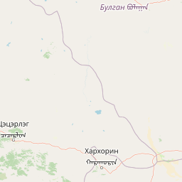
Use this park location map to pinpoint Ögii Lake in Mongolia, understand its exact geographic position, and read its mapped placement within the surrounding landscape more clearly.

Pigeon | © OpenStreetMap contributors

Location context for Ögii Lake

Arkhangai Province

Explore high-resolution park imagery capturing freshwater habitats, shallow shorelines, and open grasslands.

Ögii Lake Photos and Landscape Scenery: Visualizing the Central Mongolian Steppe Wetland

Visual documentation reveals the expansive steppe basin, shallow freshwater margins, and diverse wetland environments defining Ögii Lake. Photographic records illustrate the remote geographic character, seasonal terrain transitions, and migratory bird habitats across the protected area.

A wide, low-angle shot of the gravelly shoreline of a large, calm lake under a heavy, grey, cloudy sky in Mongolia.

Park atlas

Compare adjacent steppe wetlands and regional conservation areas in central Mongolia.

Explore Other Parks Near Ögii Lake and Surrounding Protected Landscapes

Continue exploring regional protected areas and neighboring wetland habitats after viewing Ögii Lake. Comparing nearby steppe terrain and connected ecological zones reveals the broader geographic spread of conservation lands across the region.
National parkMongolia
About 74 km away#1 closest

Southeast

Khogno Khan National Park: A National Park with Distinct Mongolian Landscape Identity

Explore its mapped terrain and regional geographic context.

Khogno Khan National Park is a designated national park offering a specific focus for protected landscape discovery. Users can explore its geographic placement within Mongolia and understand its role as a mapped natural area. The park's identity as a protected territory provides critical context for those interested in the atlas of East Asian landscapes and regional geography, highlighting a distinct area for geographic study.

Area
841 km²
Established
2003
IUCN
II
Relief
Mountain
National parkMongolia
About 121 km away#2 closest

Southwest

Khangai Nuruu National Park: Discover Mongolia's Protected Mountain Landscape and Atlas Context

Explore mapped boundaries and diverse ecosystems across its terrain.

Khangai Nuruu National Park stands as a vast national park in central Mongolia, characterized by its diverse protected landscapes and significant geographic scope. Spanning the Khangai Mountains, it presents a remarkable ecological transition from alpine meadows and taiga forests to steppe and riparian environments. This park offers a rich atlas exploration opportunity, highlighting its mapped boundaries and the unique regional geography that defines its protected status, making it a key point of discovery for understanding Mongolian conservation areas.

Area
8,885 km²
Established
1996
IUCN
II
Relief
Mountain
National parkTöv Province
About 222 km away#3 closest

East

Hustai National Park: Geographic and Protected Landscape Profile in Töv Province

Steppe, mountain, and riverine ecosystem mapping

Hustai National Park serves as a landmark conservation site in Töv Province, protecting a distinct gradient between the Khustai mountain ridges and the surrounding Mongolian plains. The area is defined by its role in steppe ecology, featuring varied slopes, riverine woodlands, and expansive grasslands that support a unique assembly of wildlife within the broader central Mongolian region.

Area
506 km²
Established
2003
IUCN
II
Relief
Mountain
National parkMongolia
About 227 km away#4 closest

West

Khorgo-Terkhiin Tsagaan Nuur National Park: A Volcanic Landscape and Wetland Atlas

Mapping volcanic terrain and migratory bird habitats in the Khangai Mountains.

This protected area features the dramatic remnants of the Taryatu-Chulutu volcanic field, centered on the extinct Khorgo volcano and the deep waters of Terkhiin Tsagaan Lake. The park provides an essential refuge for avian populations in its western marshlands, contrasting with the surrounding forest steppe. Explore the unique topography and ecological boundaries of this significant Mongolian conservation landscape.

Area
8 km²
Established
1965
IUCN
II
Relief
Mountain
A minimalist watercolor painting showing a soft, hazy landscape of green rolling hills and distant mountains bordering a light-colored lake.
National parkArkhangai Province
About 232 km away#5 closest

West

Khorgo-Terkhiin Tsagaan Nuur National Park: Volcanic Terrain and Lake Geography

A protected highland landscape in Arkhangai Province

Explore the distinct physical geography of Khorgo-Terkhiin Tsagaan Nuur National Park, where the extinct Khorgo volcano borders a vast freshwater lake. This protected area offers a look at the mosaic of birch forest and alpine slopes within the Khangai range. The mapping of this central Mongolian site reveals how volcanic activity and mountain hydrology converge to shape its unique natural horizon.

Relief
Mountain
Climate
Alpine
Scope
Terrestrial
Water
Water-dominated
National parkMongolia
About 233 km away#6 closest

East

Khustain Nuruu National Park: Mongolia's Steppe Wilderness & Przewalski's Horse Conservation Area

Explore its mapped protected landscape and regional geography.

Khustain Nuruu National Park is a protected area in Mongolia celebrated for its pivotal role in the conservation and reintroduction of the Przewalski's horse, the last truly wild horse species. This national park preserves the unique steppe terrain and rolling hills characteristic of the Mongolian Plateau, serving as a crucial habitat for native wildlife. Understanding Khustain Nuruu National Park provides a focused look into successful wildlife recovery efforts and the geographic context of Central Asian protected lands.

Established
1993
IUCN
II
Relief
Mountain
Scope
Terrestrial
Wildlife reserveÖvörkhangai Province
About 307 km away#7 closest

South

Taatsiin Tsagaan Lake Wildlife Reserve: Mapped Landscapes and Wetland Conservation in Övörkhangai Province

A critical saline wetland node within the Gobi Desert ecosystem.

Taatsiin Tsagaan Lake represents a substantial inland saline water body, defined by its role as an Important Bird Area and key wetland habitat. As part of the Valley of the Lakes, this wildlife reserve demonstrates the ecological significance of arid-land basins. Explore its geographic boundaries and position within the broader Gobi Desert landscape to understand its value in regional avian conservation.

Area
252 km²
Established
1998
Relief
Lowland
Climate
Arid
A horizontal watercolor painting depicting a soft-toned mountain range with layered green hills and distant, hazy peaks in pastel pink and purple hues.
Biosphere reserveUlaanbaatar
About 316 km away#8 closest

East

Bogd Khan Uul Biosphere Reserve: Mapped Protected Landscapes and Geographic Overview

Highland ecosystems and forest steppe in the Khentii Mountains.

Rising directly south of Ulaanbaatar, Bogd Khan Uul Biosphere Reserve protects a compact mosaic of habitats including larch forests, Siberian pine stands, and alpine rock. The reserve serves as a critical geographic marker, illustrating the rapid shift from urban fringes to subalpine wilderness while maintaining a history of sacred environmental protection that informs its current status as a biosphere reserve.

Area
673 km²
Established
1996
Relief
Mountain
Climate
Boreal

Common questions about visiting, size, designation, and location context for Ögii Lake

Ögii Lake FAQs for park facts, access, geography, and protected area context

Find quick answers about Ögii Lake, including protected-area facts, park geography, trail and visitor context, and how the park fits into its surrounding country and regional landscape.
MoriAtlas Explorer

Continue Your Protected Areas Search Across the Global Atlas

Deepen your exploration by continuing the structured search for national parks and protected areas worldwide. Utilize the comprehensive filtering capabilities to compare different conservation landscapes and refine your understanding of global park geography. Discover more about the distribution and characteristics of protected natural areas.

Global natural geography