Mori Atlas logo
Nature reservePai Forest

Analyzing the ecological intersection of canal fed riverine and arid zone flora

Pai Forest Nature Reserve: A Protected Riverine and Arid Landscape in Sindh Pakistan

Pai Forest stands as a significant protected nature reserve along the banks of the Indus River in the Sindh province of Pakistan. This compact forest habitat showcases an unusual convergence of moisture loving riverine vegetation and resilient arid zone plant species, sustained by a delicate canal irrigation network. The area serves as a critical ecological pocket within the intensively cultivated plains of the Shaheed Benazirabad district, providing vital insight into the remaining natural terrain of the Indus floodplain.

protected forestriverine forestarid forestIndus floodplaincanal-fed ecosystemflora diversity

Pai Forest

Nature reserve

Park overview

Structured park overview, official facts, and landscape profile for Pai Forest

Pai Forest park facts, protected area profile, and essential visitor context

Review the core facts for Pai Forest, including designation, size, terrain, visitor scale, habitats, and operating context in one park-focused overview.

About Pai Forest

Pai Forest occupies a distinctive niche among Sindh's protected natural areas. It is located on the left bank of the Indus River, near the town of Sakrand in Shaheed Benazirabad District, in a region of central Sindh that is otherwise dominated by agriculture and human settlement. Within this intensively used landscape, the forest functions as a surviving pocket of natural vegetation, blending arid-climate species with more water-dependent riverine plants that thrive thanks to canal-fed moisture.

The forest covers an area on the order of 4,777 acres, making it modest in scale compared with many of Pakistan's larger national parks and reserves. Its ecological importance is therefore tied less to sheer size than to the diversity it sustains. Botanical surveys of the area have recorded 122 species of flora, a figure that underscores how a relatively small but well-watered forest in an arid region can support an unusually rich plant community.

Water is the defining environmental factor for Pai Forest. Without the flows delivered by the Rahib Shah Minor Canal, a branch of the larger Rohri Canal system, the vegetation here could not persist in the dry Sindh climate. The canal allows the forest to maintain green cover and supports the conditions under which riverine and arid species grow side by side. This dependence on managed water, however, also makes the forest vulnerable: changes in canal flow or in upstream water availability have a direct impact on the habitats within it.

The forest is officially recognized as a protected forest, a designation that places it under formal state protection. Despite this status, it faces significant ongoing pressures. Encroachment by land-grabbers seeking to convert forested areas to other uses has been a persistent challenge, and the growing scarcity of water in the region further compounds the risk. These twin pressures, physical encroachment and declining water availability, shape both the current condition and the future outlook of Pai Forest as a living, functioning ecosystem rather than merely a formally designated protected area on paper.

Quick facts and research context for Pai Forest

Pai Forest lies in Sakrand Taluka, Shaheed Benazirabad District, in the Sindh province of Pakistan. It sits on the left bank of the Indus River and represents one of the smaller but ecologically significant protected forests of Sindh. The forest extends over roughly 4,777 acres. Water for the forest is supplied by the Rahib Shah Minor Canal, which draws from the broader Rohri Canal irrigation network. The forest is officially designated as a protected forest, and surveys have documented a substantial number of plant species across its relatively compact area.

Protection and recognition

Review terrestrial protection parameters and official designation records for Pai Forest.

Pai Forest Protection Status and Documented Conservation Scope

Pai Forest maintains a documented terrestrial protection scope without imported international recognition sources or transboundary status. Conservation records track baseline management parameters to clarify the official protected area standing.

Protection details

Protection scope
Terrestrial
Transboundary protection
No
Park context

Deeper park guide and search-rich context for Pai Forest

Pai Forest history, landscape, wildlife, and travel context

Explore Pai Forest through its history, landscape character, ecosystems, wildlife, conservation priorities, cultural context, and seasonal travel timing in a structured park guide built for atlas discovery and search intent.

Why Pai Forest stands out

Pai Forest is best known for the unusual combination of arid and riverine plant communities compressed into a small protected area along the Indus. Its location on the left bank of the river, combined with sustained canal irrigation in an otherwise dry region, allows dry-climate scrub and more moisture-loving riverine vegetation to coexist within the same forest boundaries. This juxtaposition gives the forest an ecological character that stands out within the surrounding agricultural landscape of central Sindh. It is also recognized for the diversity of plant life recorded within its limited footprint, with documented surveys identifying a substantial number of flora species. For visitors and ecologists interested in the interface between Pakistan's Indus floodplain ecosystems and its arid-zone flora, Pai Forest offers a compact example of how riverine and dryland environments blend under managed water supply.

Pai Forest history and protected-area timeline

Pai Forest's modern identity is rooted in its designation as a protected forest in the Sindh region of Pakistan. The forest takes its character from the irrigation infrastructure of the Indus plains: it depends on water delivered through the Rahib Shah Minor Canal, a subsidiary of the Rohri Canal system, which made possible the establishment and maintenance of tree cover in an otherwise arid part of central Sindh.

Over time, the forest has faced increasing pressures from land encroachment and from the broader scarcity of water that affects many parts of the Indus basin. These pressures have shaped an ongoing debate about how the forest can be safeguarded as a functioning ecological area within a heavily populated and agriculturally intensive district. The forest's formal protected status has provided a legal basis for conservation, but practical enforcement of that status remains an ongoing challenge.

Pai Forest landscape and geographic character

Pai Forest sits on the left bank of the Indus River in central Sindh, a region characterized by flat alluvial terrain typical of the Indus floodplain. The surrounding landscape is heavily cultivated and divided by an extensive network of irrigation canals, with towns, villages, and farmlands stretching across the plain. The forest itself stands out as a comparatively green island within this largely agricultural setting.

The Rahib Shah Minor Canal plays a key role in shaping the forest's surface character, providing the moisture that allows vegetation to thrive where natural rainfall alone would be insufficient. As a result, the forest displays a mix of dryland scrub elements typical of arid Sindh and more lush, water-supported vegetation characteristic of riverine environments. The slight topographic variation and proximity to the Indus also influence soil moisture and support local microhabitats within the forest's boundaries.

Because the forest is relatively compact and embedded in a populated district, its visual character is shaped as much by the contrast with its surroundings as by its internal features. From within or near the forest, the experience is one of sudden greenery framed by the flat expanses of farmland, settlements, and canal infrastructure that define central Sindh.

Pai Forest ecosystems, habitats, and plant life

The ecological character of Pai Forest is defined by the unusual coexistence of arid and riverine vegetation types within a relatively small area. On one hand, the forest contains plant species adapted to the dry, hot conditions typical of Sindh's climate. On the other, the canal-supplied water sustains vegetation more typical of river margins and floodplain environments. The blending of these two ecological influences gives the forest a botanical richness that distinguishes it from purely arid scrublands and from purely riverine belts.

Botanical surveys of the forest have documented 122 species of flora, a figure that highlights how this combination of conditions allows a diverse plant community to thrive. The forest's tree cover, understorey, and ground-level vegetation together create layered habitat structure that supports a range of animal life, including resident and possibly migratory species associated with both arid and riverine environments.

The forest's ecological value is heightened by its location within a heavily modified landscape. In a region where natural vegetation has been reduced to scattered remnants amid cultivation and settlement, Pai Forest represents a relatively intact strip of habitat. Its combination of dryland and riverine plants within a single protected block gives it an unusual ecological profile for Sindh, and makes it a meaningful reference point for understanding how Indus basin vegetation responds to both natural and managed water inputs.

Pai Forest wildlife and species highlights

Pai Forest's mix of arid and riverine vegetation supports a diverse community of fauna, including species drawn to both dryland and water-associated habitats. While the forest's compact size limits the scale of its wildlife populations, the blend of dry scrub, denser vegetation along watered zones, and proximity to the Indus provides niches for a wide range of animals adapted to these conditions.

The forest's value for wildlife is tied closely to its plant diversity; richer vegetation means more food resources and shelter, and the presence of both dryland and water-influenced habitats broadens the range of species that can find suitable conditions. Local fauna generally includes small mammals, reptiles, and birds typical of the Sindh plains, although the forest's ecological profile also makes it relevant for species that depend on denser vegetation stands than are common in purely agricultural areas nearby.

Because the forest is surrounded by farmland and settlements, its wildlife interacts closely with the human landscape. This makes the forest's continued existence important not only for resident species but also for the ecological connectivity it provides in an otherwise heavily used environment.

Pai Forest conservation status and protection priorities

Pai Forest is officially recognized as a protected forest under Pakistani law, a designation that establishes its legal status as an area where vegetation and habitat are intended to be preserved. Its conservation significance lies in its representation of both arid and riverine ecological systems within a small, formally protected footprint along the Indus. In a region where natural land cover has been substantially reduced by agriculture, settlement, and infrastructure, such protected pockets play an important role in retaining native flora and fauna.

The forest is closely tied to water supplied through the Rahib Shah Minor Canal, and its ecological condition is therefore directly linked to water management in the Indus basin. Continued flows are essential for sustaining the vegetation that defines the forest; reductions in water availability have an immediate impact on habitat quality and wildlife support within the protected area.

Alongside its ecological role, Pai Forest faces significant conservation challenges. Land grabbing and encroachment pressure have been recurring issues, as surrounding communities and developers seek to convert forest land to other uses. Compounding this, scarcity of water in the region threatens the long-term viability of the canal-fed vegetation on which the forest depends. Conservation of Pai Forest therefore depends not only on formal protection but on the practical safeguarding of its land base and the maintenance of reliable water supply.

Pai Forest cultural meaning and human context

Pai Forest sits among the agricultural communities of Sakrand Taluka in Shaheed Benazirabad District, an area with deep roots in the irrigated farming traditions of the Indus plains. The forest is interwoven with this local human landscape: its continued existence has depended on irrigation infrastructure that also serves surrounding farmland, and local communities have long interacted with the forest for resources and as a landmark within an otherwise cultivated plain.

In Sindh, where natural tree cover has been reduced across much of the central landscape, surviving protected forests like Pai hold a particular local resonance. They stand as reminders of the region's natural heritage within a heavily cultivated and populated setting, and they feature in local discussions about land use, water sharing, and environmental protection.

Top sights and standout views in Pai Forest

Pai Forest stands out for packing both arid and riverine ecology into a small, formally protected forest along the Indus in Sindh. Its tree cover depends on canal irrigation, and its plant diversity is unusually high for its size, with 122 recorded flora species. The forest plays an important role as one of the surviving natural habitat pockets in an intensively cultivated district, though it remains under pressure from land encroachment and water scarcity.

Best time to visit Pai Forest

Because Pai Forest lies in the arid climate of central Sindh, the cooler months from late autumn through early spring tend to offer the most comfortable conditions for spending time outdoors. Summer in this part of Pakistan is hot and dry, with temperatures that can make extended outdoor activity difficult, while the mild winter season brings cooler weather and clearer opportunities to observe vegetation and wildlife. As with any visit to a canal-fed forest in an arid region, the visible state of vegetation will depend on water availability at the time of the visit.
Monthly climate preview

Long-term monthly temperature averages and precipitation patterns for Pai Forest

Pai Forest Climate Normals, Annual Temperature and Precipitation Rhythms

Representative coordinate records show measured monthly temperature variations alongside low precipitation rates across the annual cycle. Detailed monthly breakdowns provide deeper insight into long-term climate normals and seasonal temperature shifts.
Annual mean28 °C
17 °C36 °C
Jan17°
Feb20°
Mar26°
Apr31°
May35°
Jun36°
Jul34°
Aug33°
Sep32°
Oct29°
Nov24°
Dec18°
Warmest month
June

35.6 °C

Coolest month
January

16.8 °C

Wettest month
August

1.4 mm/day

Driest month
November

0.1 mm/day

Park location guide

Geography guide, regional context, and park location map for Pai Forest

Pai Forest park geography, regions, and map view in Pakistan

Understand where Pai Forest sits in Pakistan through a broader geographic reading of the surrounding landscape, nearby location context, and its mapped position within the national park landscape.

How Pai Forest fits into Pakistan

Pakistan, officially the Islamic Republic of Pakistan, is a federal parliamentary Islamic republic in South Asia. It is the fifth-most populous country and the 33rd-largest by area. The country gained independence from British India in 1947 and has a diverse history spanning ancient civilizations including Mehrgarh and the Indus Valley Civilisation. Pakistan shares maritime borders with Oman and is bounded by the Arabian Sea, Gulf of Oman, and several neighboring countries.

Wider geography shaping Pai Forest in Pakistan

Pakistan is located in South Asia, bordered by the Arabian Sea to the south, the Gulf of Oman to the southwest, and shares land borders with India to the east, Afghanistan to the west, Iran to the southwest, and China to the northeast. The country also shares a maritime border with Oman in the Gulf of Oman. The Wakhan Corridor in Afghanistan separates Pakistan from Tajikistan in the northwest.

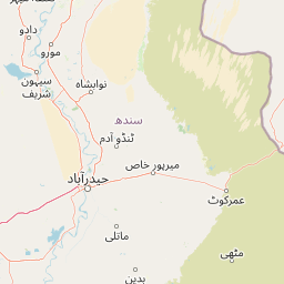
Map view of Pai Forest

Use this park location map to pinpoint Pai Forest in Pakistan, understand its exact geographic position, and read its mapped placement within the surrounding landscape more clearly.

Pigeon | © OpenStreetMap contributors

Location context for Pai Forest

Sindh
Park atlas

Compare adjacent riverine reserves and regional conservation landscapes

Parks Near Pai Forest and Related Protected Areas in the Surrounding Region

Explore other protected areas near Pai Forest to examine connected riverine habitats and arid ecosystems across the Indus floodplain. Regional park comparisons reveal wider ecological patterns and survival strategies among similar canal-fed sanctuaries.
National parkPakistan
About 80 km away#1 closest

Southwest

Kirthar National Park: Discover Pakistan's Arid Mountain Protected Landscape

Explore the mapped geography and unique terrain of this vital national park.

Kirthar National Park represents a critical expanse of protected semi-arid mountainous terrain in southern Pakistan, covering over 3,000 square kilometers. It is recognized for its significant populations of Sindh ibex, urial, and chinkara gazelles, alongside a diverse array of raptors, including migratory vulture and eagle species. The park's unique landscape, characterized by parallel ridges and deep, dry valleys, provides crucial habitat in a region facing considerable development pressures, offering a distinct geographical context for protected area exploration.

Area
3,087 km²
Established
1974
IUCN
II
Relief
Mountain
Wildlife reserveSindh
About 82 km away#2 closest

North

Deh Akro-II Desert Wetland Complex: Protected Landscape and Geographic Mapping

Inland wetland and desert sanctuary in Sindh, Pakistan

Explore the distinctive geography of Deh Akro-II Desert Wetland Complex, a protected wildlife reserve defined by its unusual combination of sand dunes and freshwater lakes. This atlas entry details the natural terrain and ecological boundaries of one of Pakistan's most significant inland wetland systems, illustrating the complex intersection of arid and aquatic habitats within the Indus River system.

Area
205 km²
Established
1988
Relief
Lowland
Climate
Arid
Watercolor painting of a calm lake with grassy foreground, small islands, and distant hills under a soft light.
Wildlife reserveSindh
About 129 km away#3 closest

South

Keenjhar Lake Wildlife Reserve: Sindh Province Protected Wetland and Geographic Atlas

Mapped freshwater wetland and regional wildlife sanctuary

Keenjhar Lake is a prominent freshwater wetland and wildlife reserve in the Thatta District of Sindh. This expansive basin serves as a key ecological anchor for migratory waterbirds and a central feature of the regional landscape. The area combines significant hydrological value with distinct cultural history, providing a unique look into the protected geography of southeastern Pakistan.

Area
134.68 km²
Relief
Lowland
Scope
Terrestrial
Water
Water-dominated
A wide watercolor painting showing a body of water in the foreground, green trees and shrubs in the middle ground, and rolling hills in the background under a pale sky.
Protected areaThatta District
About 151 km away#4 closest

South

Haleji Lake Protected Area: Mapping Wetlands and Freshwater Ecosystems in Thatta District

A significant freshwater reservoir and Ramsar site in southern Sindh, Pakistan.

Situated in the low-lying plains of Thatta District, Haleji Lake functions as an essential freshwater sanctuary for migratory bird species. The site features a distinct mosaic of managed reservoirs, fringing marshes, and brackish lagoons, offering a unique look at the interaction between water engineering and natural wetland conservation in the Indus basin.

Area
6.58 km²
Established
1943
Relief
Lowland
Scope
Terrestrial
Wildlife reserveSindh
About 166 km away#5 closest

North

Drigh Lake Wildlife Reserve: Protected Wetland Geography in Sindh, Pakistan

Mapped freshwater habitat in the Indus river basin

Drigh Lake is a designated wildlife sanctuary and Ramsar site in the Qambar Shahdadkot District of Sindh. This protected area features shallow, reed-fringed freshwater environments that serve as an essential waterbird haven. Analyze the park boundaries and the surrounding alluvial plains that characterize this significant regional wetland geography.

Area
1.64 km²
Established
1972
Scope
Terrestrial
Water
Water-dominated
Wildlife reserveKhairpur District
About 175 km away#6 closest

North

Mehrano Wildlife Sanctuary: Protected Forest Landscapes and Geography in Khairpur District

A historic wildlife reserve along the Indus riverine corridor.

Mehrano Wildlife Sanctuary represents a unique intersection of private historical stewardship and modern conservation. This riverine forest in Khairpur District provides a critical habitat for large game and migratory bird populations, functioning as a lush ecological refuge at the edge of the Cholistan desert. The terrain offers a distinct study in Indus floodplain geography and long-standing protected land management.

Area
2.8 km²
Established
1790
Relief
Lowland
Scope
Terrestrial
Wildlife reserveSindh
About 200 km away#7 closest

South

Jubho Lagoon Wildlife Reserve: Coastal Wetland Geography and Regional Map Context

Mapping brackish lagoons and migratory bird habitats in Sindh

Investigate the protected landscape of Jubho Lagoon, a shallow brackish wetland in southern Sindh. The area features a complex mosaic of tidal inlets, exposed mudflats, and freshwater-influenced marshes that serve as a primary regional habitat for migratory flamingos and pelicans.

Area
7.06 km²
Established
2001
Relief
Lowland
Scope
Terrestrial
A pale, minimalist watercolor painting showing soft green hills or islands against a light, misty horizon.
Marine protected areaBalochistan
About 212 km away#8 closest

Southwest

Churna Island Marine Protected Area: Geography and Coastal Atlas of Balochistan

Mapping the coral reef systems and rocky island terrain

Churna Island represents a unique marine protected area located near the border of Balochistan and Sindh. Characterized by a desolate rocky surface, the true ecological value resides in its extensive submerged reef structures, which provide habitat for a vast array of coral species and pelagic fish. This atlas resource provides a structured look at the island's coastal geography and its growing role in regional marine conservation.

Area
0.6 km²
Established
2024
Relief
Upland
Climate
Subtropical

Common questions about visiting, size, designation, and location context for Pai Forest

Pai Forest FAQs for park facts, access, geography, and protected area context

Find quick answers about Pai Forest, including protected-area facts, park geography, trail and visitor context, and how the park fits into its surrounding country and regional landscape.
MoriAtlas Explorer

Continue Your Protected Areas Search Across the Global Atlas

Deepen your exploration by continuing the structured search for national parks and protected areas worldwide. Utilize the comprehensive filtering capabilities to compare different conservation landscapes and refine your understanding of global park geography. Discover more about the distribution and characteristics of protected natural areas.

Global natural geography