Mori Atlas logo
National parkParc national du Mont Sangbé

Mapping the rugged terrain and mountainous forest ecosystems of western Côte d'Ivoire.

Parc national du Mont Sangbé: A Highland Protected Landscape in the Montagnes District

Parc national du Mont Sangbé encompasses a rugged mountainous landscape in western Côte d'Ivoire, featuring more than fourteen summits that exceed 1,000 meters in elevation. This protected area serves as a critical refuge for dense forest ecosystems and wildlife, providing a rare highland profile that contrasts with the surrounding lowlands. The park boundaries preserve this complex three-dimensional terrain, which supports elephants, buffalo, and a variety of birdlife, anchoring the conservation geography of the Montagnes District.

mountain foresthighland landscapetropical forestnational parkwildlife refugelarge mammals

Parc national du Mont Sangbé

National park

Park overview

Structured park overview, official facts, and landscape profile for Mount Sangbé National Park

Mount Sangbé National Park park facts, protected area profile, and essential visitor context

Review the core facts for Mount Sangbé National Park, including designation, size, terrain, visitor scale, habitats, and operating context in one park-focused overview.

About Mount Sangbé National Park

Mount Sangbé National Park occupies a significant portion of the western highlands of Côte d'Ivoire, lying in the country's Montagnes District near the regional city of Man. It spans the prefectures of Biankouma, Touba, and Séguéla, positioning it at a crossroads of the country's mountainous interior. The park's surface area reaches roughly 97,500 hectares, placing it among the larger protected landscapes in Côte d'Ivoire.

The defining feature of the park is its elevation. The terrain rises into at least fourteen peaks above 1,000 meters, an uncommon topographic condition in much of Côte d'Ivoire and a key element of the park's individuality. These mountains support a very dense forest cover, which extends across the slopes and valleys and forms the matrix of the park's ecosystems. The combination of altitude and forest cover creates a humid, layered environment that supports a wide range of plant life.

Wildlife has long been central to the park's identity. Elephants, buffalo, antelopes, and several monkey species constitute the core of its fauna. Reports from recent years suggest a broader recovery, with the return of additional mammals and birds to areas that had seen depletion in prior decades. Among the species observed in 2019 were warthogs, hippotragus antelopes, porcupines, wild guinea fowl, and Great Blue Turacos, the last of which is a particularly striking forest bird of West Africa.

Mount Sangbé National Park is administrated by the Office ivoirien des parcs et réserves, the national authority responsible for Côte d'Ivoire's network of protected landscapes. The park carries an IUCN Category II classification, recognizing it as a formally managed national park. As a continuous block of mountainous forest in the West African interior, it serves as a refuge for biodiversity and as a reminder of the value of highland ecosystems in a region where such terrain is geographically rare.

Quick facts and research context for Mount Sangbé National Park

Mount Sangbé National Park is located in western Côte d'Ivoire, close to the city of Man, and crosses the prefectures of Biankouma, Touba, and Séguéla. The park spans roughly 97,500 hectares of mountainous terrain within the Montagnes District of the country. It was established in February 1976, originating from a former state forest and later designated as a national park.

The park is classified as an IUCN Category II protected area and is administered by the Office ivoirien des parcs et réserves. Its defining physical characteristic is its highland setting, with at least fourteen summits rising above 1,000 meters. The combination of elevation, dense forest cover, and recurring wildlife presence has made it a recognized conservation area in the West African region.

Protection and recognition

Examine documented terrestrial conservation frameworks and official records.

Parc National du Mont Sangbe Protection Status and Recognition Data

Terrestrial protection status for Parc national du Mont Sangbé outlines established conservation frameworks and administrative boundaries. Official database records provide verified boundary data and registry entries for regional analysis.

Protection details

Protection scope
Terrestrial
Transboundary protection
No
WDPA ID
723
Park context

Deeper park guide and search-rich context for Mount Sangbé National Park

Mount Sangbé National Park history, landscape, wildlife, and travel context

Explore Mount Sangbé National Park through its history, landscape character, ecosystems, wildlife, conservation priorities, cultural context, and seasonal travel timing in a structured park guide built for atlas discovery and search intent.

Why Mount Sangbé National Park stands out

Mount Sangbé National Park is best known for its mountainous terrain and the dense tropical forest that cloaks its elevation. Its skyline of more than fourteen peaks above 1,000 meters gives the park a distinctive highland character unusual in Côte d'Ivoire. The park is also recognized for its population of large mammals, including elephants, buffalo, antelopes, and monkeys. In addition to its established wildlife base, Mount Sangbé has drawn attention for the gradual return of additional species in recent years, signaling ecological recovery. Animals such as warthogs, hippotragus antelopes, porcupines, wild guinea fowl, and the striking Great Blue Turaco have reappeared within the park. This revival of fauna, combined with the mountain forest setting, defines the identity of the park as a place where West African highland ecosystems and their wildlife continue to find refuge.

Mount Sangbé National Park history and protected-area timeline

Mount Sangbé National Park traces its origins to a former state forest, or forêt domaniale, that had been under governmental stewardship before its designation as a national park. On February 19, 1976, the park was formally created through decree 76-215, transforming the prior forest estate into a protected national park. Since its establishment, the park has been administered by the Office ivoirien des parcs et réserves, the Ivorian institution responsible for managing the country's network of parks and reserves.

In the decades following its designation, the park served as one of the key refuges for forest wildlife in western Côte d'Ivoire. By 2019, surveys indicated that a broader suite of species had reappeared within its boundaries, including warthogs, hippotragus antelopes, porcupines, wild guinea fowl, and Great Blue Turacos. This shift suggested an ongoing ecological recovery, marking a meaningful moment in the park's conservation trajectory.

Mount Sangbé National Park landscape and geographic character

Mount Sangbé National Park is a mountainous protected landscape in the west of Côte d'Ivoire. Its terrain rises into at least fourteen peaks exceeding 1,000 meters in elevation, giving the park a rare highland profile in a country where most terrain is lower and flatter. These peaks create a varied topographic silhouette, with slopes, ridges, and valleys alternating across the protected area.

The dense forest cover that blankets the park is closely tied to its elevation. The mountainous setting supports a continuous canopy of trees across much of the surface, while breaks in elevation expose slopes, rocky areas, and stream corridors that diversify the scenery. The combined effect of highland relief and forest cover produces a layered, three-dimensional landscape that distinguishes Mont Sangbé from the surrounding lowland regions of West Africa.

Mount Sangbé National Park ecosystems, habitats, and plant life

The ecological identity of Mount Sangbé National Park is rooted in its mountain forest environment. The steep terrain and abundant moisture support a very dense flora, with closed-canopy forest extending across the slopes and valleys of the park. This highland forest ecosystem is a relatively uncommon ecological setting within Côte d'Ivoire, where lower elevations dominate the country's vegetation patterns.

The interplay between elevation, humidity, and forest cover creates a habitat mosaic that supports a diverse range of plant and animal life. The continuity of canopy and the relative remoteness of the terrain help preserve ecological processes across a substantial protected area. Within this context, the park functions as a refuge for wildlife species that depend on intact forest cover and the structural complexity that mountainous terrain provides.

Mount Sangbé National Park wildlife and species highlights

Wildlife is a central feature of Mount Sangbé National Park. The park has long supported populations of large mammals, including elephants, buffalo, antelopes, and several monkey species. These species form the backbone of the park's fauna and reflect the availability of forested habitat at elevations that range from valley floors to mountain summits.

In 2019, additional species were reported within the park, signaling an expansion of its faunal base. Warthogs, hippotragus antelopes, porcupines, wild guinea fowl, and Great Blue Turacos were observed in the area, indicating a recovery of species that had been less visible in earlier periods. The presence of the Great Blue Turaco, a charismatic blue forest bird, adds further ecological interest to the park's birdlife. Together, these species highlight the role of Mont Sangbé as a habitat for both resident and returning wildlife in West Africa.

Mount Sangbé National Park conservation status and protection priorities

Mount Sangbé National Park is recognized as an IUCN Category II protected area, confirming its status as a formally managed national park within Côte d'Ivoire. It is administered by the Office ivoirien des parcs et réserves, the country's institutional body for parks and reserves management. The park's designation in 1976, through decree 76-215, transformed a former state forest into a protected national park, anchoring its long-term conservation status.

The park's conservation value is closely linked to its mountainous forest setting. Elevations above 1,000 meters and dense forest cover make the park ecologically distinctive within Côte d'Ivoire, where such highland forest is rare. Reports of returning wildlife, including species noted again in 2019, point to an evolving conservation story in which the park continues to regain some of the fauna that characterized it in earlier decades.

Top sights and standout views in Mount Sangbé National Park

Mount Sangbé National Park is distinguished by a combination of mountainous terrain, dense forest cover, and a returning suite of wildlife. Its fourteen-plus peaks rising above 1,000 meters create a highland landscape that is unusual in Côte d'Ivoire and that provides the underlying structure for the park's ecological character. The forest blanketing these elevations supports elephants, buffalo, antelopes, and monkeys as core species, while more recent arrivals such as warthogs, hippotragus antelopes, porcupines, wild guinea fowl, and Great Blue Turacos have added to the park's faunal profile.

As a long-standing national park under the management of the Office ivoirien des parcs et réserves, Mount Sangbé represents an important element of Côte d'Ivoire's system of protected areas. Its scale, its elevation, and the ongoing recovery of its wildlife together define its standing as a meaningful conservation landscape in West Africa.

Best time to visit Mount Sangbé National Park

Mount Sangbé National Park lies in the mountainous west of Côte d'Ivoire, where the climate follows the broader West African pattern of a dry season and a wet season. The dry season, generally running from around November through March, tends to bring clearer skies, more accessible forest trails, and improved visibility for observing wildlife in more open conditions along forest edges and water sources.

The wet season, roughly from April through October, brings heavier rains and lusher vegetation, which can make trails more challenging but also intensify the density and freshness of the forest canopy. Bird activity and mammal movements are often shaped by these seasonal patterns. Visitors interested in lush forest scenery may favor the wet season, while those focused on easier access and wildlife observation along more open areas often prefer the dry months.

Monthly climate preview

Long-term representative temperature and precipitation patterns across twelve months

Parc national du Mont Sangbé climate normals and monthly temperature rhythm

Representative coordinates record measured monthly temperature swings from 23.32 to 27.57 degrees Celsius alongside shifting precipitation rates from 0.3 to 7.91 millimeters per day. Examining the complete monthly climate normals reveals full seasonal shifts and detailed temperature ranges across the protected landscape.
Annual mean25 °C
23 °C28 °C
Jan25°
Feb27°
Mar28°
Apr27°
May26°
Jun25°
Jul24°
Aug23°
Sep24°
Oct24°
Nov25°
Dec24°
Warmest month
March

27.6 °C

Coolest month
August

23.3 °C

Wettest month
August

7.9 mm/day

Driest month
January

0.3 mm/day

Park location guide

Geography guide, regional context, and park location map for Mount Sangbé National Park

Mount Sangbé National Park park geography, regions, and map view in Ivory Coast

Understand where Mount Sangbé National Park sits in Ivory Coast through a broader geographic reading of the surrounding landscape, nearby location context, and its mapped position within the national park landscape.

How Mount Sangbé National Park fits into Ivory Coast

Ivory Coast, officially the Republic of Côte d'Ivoire, is a West African country with a coastline on the Gulf of Guinea. It gained independence from France in 1960 and is now a presidential republic. The country is a major producer of cocoa and coffee, with Abidjan serving as its largest city and economic hub, while Yamoussoukro is the official capital.

Wider geography shaping Mount Sangbé National Park in Ivory Coast

Ivory Coast is situated on the southern coast of West Africa along the Gulf of Guinea. It borders Guinea to the northwest, Liberia to the west, Mali to the northwest, Burkina Faso to the northeast, Ghana to the east, and the Atlantic Ocean to the south. The terrain includes coastal plains, interior highlands, and forested regions.

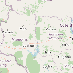
Map view of Mount Sangbé National Park

Use this park location map to pinpoint Mount Sangbé National Park in Ivory Coast, understand its exact geographic position, and read its mapped placement within the surrounding landscape more clearly.

Pigeon | © OpenStreetMap contributors

Location context for Mount Sangbé National Park

Montagnes
Park atlas

Compare regional highland landscapes and connected conservation areas in West Africa

Parks Near Parc national du Mont Sangbé and Related Protected Areas

Visitors reviewing Parc national du Mont Sangbé can browse adjacent national parks and protected landscapes across the surrounding region. Expanding the geographic comparison provides deeper context into regional topography, highland terrain, and tropical forest habitats.
National parkIvory Coast
Mapped park locations coincide#1 closest

Mont Sângbé National Park National Park: Ivory Coast Protected Area Geography and Map Exploration

Explore the mapped natural landscape of Mont Sângbé National Park.

Mont Sângbé National Park is a protected national park offering a unique geographic perspective within Ivory Coast. This entry facilitates exploration of its mapped boundaries and regional landscape context, contributing to a broader understanding of protected areas in West Africa through structured atlas data. Discover the essential geographic elements that define this conservation landscape.

Area
950 km²
Established
1976
IUCN
II
Relief
Mountain
National parkIvory Coast
About 106 km away#2 closest

South

Mont Péko National Park: Ivory Coast National Park with Mapped Boundaries

Explore its protected landscape and regional geography.

Delve into Mont Péko National Park, a designated national park within Ivory Coast, to understand its unique protected landscape. This entry facilitates detailed atlas exploration, focusing on its geographic placement, mapped boundaries, and contribution to the regional natural terrain. Discover the essence of this protected area through its mapped geography and landscape identity.

Area
340 km²
Established
1968
IUCN
II
Relief
Mountain
National parkMontagnes
About 108 km away#3 closest

South

Parc national du Mont Péko: Mountain Rainforest and Granite Inselberg Geography

Protected mountain massif and watershed within the Montagnes District

Discover the unique mountain landscape of Parc national du Mont Péko. This protected area features dense primary forests, iconic granite inselbergs, and steep terrain that rises above the surrounding Ivorian plains. Use this mapped overview to understand its role in regional conservation and the watershed dynamics of the Sassandra River.

Area
340 km²
Established
1968
IUCN
II
Protected areaNimba County
About 148 km away#4 closest

West

Nimba National Forest: Protected Mountain Landscape & Bird Area in Nimba County

Explore mapped boundaries and regional geographic context.

Nimba National Forest, a protected area of approximately 187 square kilometers, is defined by its mountainous terrain in Nimba County, Liberia. Situated at the tri-border region with Guinea and Ivory Coast, this forest is recognized for its importance as a habitat for diverse bird species and its role in regional conservation efforts. Discover its mapped landscape, its position within the Nimba Range, and its ecological significance within West Africa's protected natural areas.

Area
187 km²
IUCN
VI
Access
Access unknown
Scope
Terrestrial
National parkSassandra-Marahoué District
About 167 km away#5 closest

Southeast

Marahoué National Park: Geographic and Protected Landscape Analysis in Central Ivory Coast

Examining the ecological terrain within the Sassandra-Marahoué District

Marahoué National Park occupies a transitional zone where forest remnants meet savanna grasslands in the heart of Ivory Coast. This analysis explores the park's geographic boundaries along the Marahoué River and the shifting habitats that continue to sustain a notable variety of bird species within this protected district.

Area
1,000 km²
Established
1968
IUCN
II
Relief
Upland
A minimalist watercolor painting depicting a soft green savanna landscape with scattered trees, rolling hills, and a central waterway, isolated on a white background.
National parkSassandra-Marahoué
About 167 km away#6 closest

Southeast

Parc national de la Marahoué: Sassandra-Marahoué Protected Landscape and River Atlas

Analyzing the savanna and forest mosaic of Côte d'Ivoire

Parc national de la Marahoué represents a critical ecological junction in Côte d'Ivoire, spanning over 100,000 hectares along the Marahoué River. This protected area offers an analytical look at the intersection of Sudano-Guinean savanna and humid forest biomes, providing a unique case study in West African conservation landscapes and biodiversity patterns within the Sassandra-Marahoué region.

Area
1,010 km²
Established
1968
IUCN
II
Scope
Terrestrial
Nature reservePréfecture de Yomou
About 201 km away#7 closest

West

Réserve forestière de Diécké: Protected Forest Geography and Landscape Features

A critical lowland rainforest zone in Guinea

The Réserve forestière de Diécké protects 64,000 hectares of primary and secondary dense forest in southeastern Guinea. Its rugged, hilly terrain and river-carved lowlands support a closed-canopy ecosystem, providing a vital model for zoned forest conservation in the West African region.

Area
640 km²
Relief
Upland
Climate
Tropical
Scope
Terrestrial
A watercolor painting depicting a soft-focus landscape with rolling green hills in the distance and a band of trees in the middle ground.
National parkDistrict des Montagnes
About 206 km away#8 closest

South

Parc national de Taï: Primary Rainforest and Protected Terrain in District des Montagnes

Mapping intact forest corridors and major drainage systems

Parc national de Taï encompasses a vast, primary evergreen rainforest landscape that anchors the Upper Guinea forest block. This protected area features a complex topography of hills, plateaus, and permanent rivers, providing a vital habitat and a major site for scientific research in Côte d'Ivoire.

Area
4,540 km²
Established
1973
IUCN
II
Relief
Lowland

Common questions about visiting, size, designation, and location context for Mount Sangbé National Park

Mount Sangbé National Park FAQs for park facts, access, geography, and protected area context

Find quick answers about Mount Sangbé National Park, including protected-area facts, park geography, trail and visitor context, and how the park fits into its surrounding country and regional landscape.
MoriAtlas Explorer

Continue Your Protected Areas Search Across the Global Atlas

Deepen your exploration by continuing the structured search for national parks and protected areas worldwide. Utilize the comprehensive filtering capabilities to compare different conservation landscapes and refine your understanding of global park geography. Discover more about the distribution and characteristics of protected natural areas.

Global natural geography