Mori Atlas logo
Protected landscapeParque Municipal y Área Natural de Manejo Integrado Gran Mojos

Geographic analysis of floodplain terrain and protected corridors in the Beni region.

Parque Municipal y Área Natural de Manejo Integrado Gran Mojos: Mapped Protected Landscapes

Parque Municipal y Área Natural de Manejo Integrado Gran Mojos encompasses a vast mosaic of primary forests and wetlands within the Mamoré River floodplain of Bolivia. This protected area serves as a critical link in the Amboró-Madidi Corridor, integrating strict municipal forest zones with managed landscapes that support local indigenous communities. The terrain is defined by seasonal flooding patterns, gallery forests, and riverine networks that provide habitat for endangered species such as the Blue-throated Macaw.

wetlandsfloodplainAmazon basinmammalsmacawsbirdwatching

Parque Municipal y Área Natural de Manejo Integrado Gran Mojos

Protected landscape

Park overview

Structured park overview, official facts, and landscape profile for Parque Municipal y Área Natural de Manejo Integrado Gran Mojos

Parque Municipal y Área Natural de Manejo Integrado Gran Mojos park facts, protected area profile, and essential visitor context

Review the core facts for Parque Municipal y Área Natural de Manejo Integrado Gran Mojos, including designation, size, terrain, visitor scale, habitats, and operating context in one park-focused overview.

About Parque Municipal y Área Natural de Manejo Integrado Gran Mojos

Parque Municipal y Área Natural de Manejo Integrado Gran Mojos is a major protected area in central Bolivia, established to preserve some of the most threatened floodplain habitats of the Llanos de Moxos. Created by the municipal government of Loreto on 25 February 2017, the area encompasses approximately 580,430 hectares within the southern portion of the Beni Department. The landscape is shaped by the central Mamoré River, whose seasonal flooding defines the ecology, hydrology, and human settlement patterns across the region.

The protected area combines two complementary land-use categories. A core Parque Municipal zone, covering about 85,000 hectares, is dedicated to the protection of primary lowland forest. The remaining 495,430 hectares are designated as an Área Natural de Manejo Integrado (ANMI), a category intended to balance conservation with the presence and livelihood of around fourteen indigenous communities. Together, these two categories cover nearly all of Loreto municipality, making Gran Mojos effectively the municipal-scale conservation framework for the area.

Gran Mojos sits at a strategic junction within Bolivia's protected-area network. It borders the Isiboro-Sécure Indigenous Territory and National Park (Tipnis) to the south and the Ibare-Mamoré Municipal Protected Area to the north, while also forming part of the broader Amboró-Madidi Corridor that links protected areas along the eastern foothills of the Andes. This geographic position helps connect lowland Amazonian floodplains to the montane ecosystems further west, enhancing the area's relevance for landscape-scale conservation.

The establishment of Gran Mojos was driven primarily by concerns over the survival of the Blue-throated Macaw (Paraba Barba Azul), a species endemic to the Beni and assessed as critically endangered, but it also aims to protect other emblematic and ecologically important species such as the jaguar and the Amazon river dolphin known locally as bufeo. The diagnostic study that informed the park's creation, carried out by Cibioma (the Center for Research on Biodiversity and Environment) and the Fundación para la Conservación de los Loros de Bolivia, identified roughly 463 species across 316 genera, suggesting a biodiversity level somewhat above what has been recorded in other protected areas of the department.

Quick facts and research context for Parque Municipal y Área Natural de Manejo Integrado Gran Mojos

Gran Mojos is a municipal-level protected area in the department of Beni, Bolivia, located in the Llanos de Moxos floodplain ecosystem. It was formally created on 25 February 2017 by the municipal government of Loreto, covering about 580,430 hectares, or roughly 95 percent of the municipality.

The area is divided into two management categories: a Parque Municipal zone of about 85,000 hectares of primary forest and an Área Natural de Manejo Integrado (ANMI) of roughly 495,430 hectares that accommodates around fourteen indigenous communities. It lies adjacent to the Isiboro-Sécure Indigenous Territory and National Park (Tipnis) to the south and the Ibare-Mamoré Municipal Protected Area to the north, forming part of the broader Amboró-Madidi conservation corridor.

Protection and recognition

Examine the terrestrial protection scope and management records for this reserve.

Parque Municipal y Área Natural de Manejo Integrado Gran Mojos Protection Status

Terrestrial protection status and designation details for Parque Municipal y Área Natural de Manejo Integrado Gran Mojos are compiled within a structured format. Conservation records outline management scope and international recognition sources for detailed landscape analysis.

Protection details

Protection scope
Terrestrial
Transboundary protection
No
Core area
850 km²
Park context

Deeper park guide and search-rich context for Parque Municipal y Área Natural de Manejo Integrado Gran Mojos

Parque Municipal y Área Natural de Manejo Integrado Gran Mojos history, landscape, wildlife, and travel context

Explore Parque Municipal y Área Natural de Manejo Integrado Gran Mojos through its history, landscape character, ecosystems, wildlife, conservation priorities, cultural context, and seasonal travel timing in a structured park guide built for atlas discovery and search intent.

Why Parque Municipal y Área Natural de Manejo Integrado Gran Mojos stands out

Gran Mojos is best known as the most important nesting stronghold of the Blue-throated Macaw (Ara glaucogularis), known locally as the Paraba Barba Azul. This macaw is endemic to the Bolivian Beni and is considered critically endangered, with an estimated total population of around 250 individuals, and the park's extensive floodplain forests are believed to hold the largest known nesting concentration of the species. Beyond its flagship macaw, the protected area stands out for combining a strict municipal park core with a large integrated management zone that supports indigenous communities. This dual structure, along with the area's position in the central Mamoré floodplain and its connection to a wider Andean foothills conservation corridor, gives Gran Mojos regional importance for Amazonian wetland conservation in Bolivia.

Parque Municipal y Área Natural de Manejo Integrado Gran Mojos history and protected-area timeline

Gran Mojos is a relatively recent addition to Bolivia's system of protected areas. It was created on 25 February 2017 through a declaration by the municipal government of Loreto, in the Beni Department. The decision emerged from an extended period of scientific and institutional groundwork focused on the conservation needs of the Llanos de Moxos floodplain.

The technical justification for the protected area was developed by Cibioma, the Centro de Investigación en Biodiversidad y Medio Ambiente (Center for Research on Biodiversity and Environment), in partnership with the Fundación para la Conservación de los Loros de Bolivia (CLB, Foundation for the Conservation of Parrots of Bolivia). These institutions produced an integral diagnostic study for the proposed area, which documented the presence of around 463 species across 316 genera and identified a range of threatened and endemic species requiring urgent protection.

Of these, the Blue-throated Macaw stood out as the central driver for formal protection. Considered endemic to the Bolivian Beni and critically endangered, with an estimated total population of only around 250 individuals, the species became the symbolic focus of the effort to create a municipal-level conservation regime. Its most important known nesting concentration lies within what is now Gran Mojos.

The final design of the protected area reflects a compromise between strict conservation and the reality of long-standing indigenous settlement in the floodplain. Rather than imposing a single uniform reserve category across the entire municipal territory, the 2017 declaration defined a core municipal park area of primary forest, complemented by a much larger Área Natural de Manejo Integrado that recognizes the continued presence and land use of approximately fourteen indigenous communities within the broader landscape.

Parque Municipal y Área Natural de Manejo Integrado Gran Mojos landscape and geographic character

The landscape of Gran Mojos is defined by the great riverine plain of central Bolivia, one of the signature landforms of the Llanos de Moxos ecoregion. The protected area lies entirely within the floodplain of the central Mamoré River, where seasonal and multi-year cycles of flooding and drying shape the terrain, vegetation, and wildlife patterns. This floodplain mosaic combines gallery forests, palm-dominated wetlands, grasslands, slow-moving channels, oxbow lakes, and patches of more elevated tierra firme that remain above the highest water levels.

Within this broader floodplain setting, the strict Parque Municipal zone preserves about 85,000 hectares of primary forest, where the canopy is largely intact and human influence has been comparatively limited. Surrounding it, the much larger Área Natural de Manejo Integrado extends across roughly 495,430 hectares of similarly low-lying terrain, supporting both natural ecosystems and the resources on which local communities depend.

The regional geography is notable for the protected area's position along a major latitudinal connectivity axis. To the south, Gran Mojos borders the Isiboro-Sécure Indigenous Territory and National Park (Tipnis), and to the north it connects with the Ibare-Mamoré Municipal Protected Area. Within the wider landscape, Gran Mojos also forms part of the Amboró-Madidi Corridor, a chain of reserves stretching from the last Andean foothills toward the western Amazon, linking lowland floodplains to montane forest environments further west. Nearby aquatic landmarks of the broader area include Laguna Bolivia, Laguna de Araré, and Laguna Aquiles, which contribute to the region's reputation as a network of seasonally flooded lakes and slow-moving waters.

Parque Municipal y Área Natural de Manejo Integrado Gran Mojos ecosystems, habitats, and plant life

Gran Mojos sits within the Llanos de Moxos, one of the most extensive wetland complexes in South America and a globally significant seasonal-flood ecosystem. The ecoregion is characterized by dynamic alternations between aquatic and terrestrial phases, with extensive palm swamps, seasonally flooded grasslands, gallery forests along rivers, and patches of higher forest on slightly elevated ground.

The protected area's primary forest core represents one of the more intact expressions of this floodplain forest mosaic. Its structure and connectivity with surrounding protected areas, especially the Amboró-Madidi Corridor, contribute to ecological processes that span from the Andes foothills to the lowland Amazon basin. These processes include seasonal migrations of fish and other aquatic species, the flooding and recession of vast grasslands, and movements of large mammals that depend on intact forest corridors.

The biodiversity assessment that informed the park's creation identified roughly 463 species distributed across 316 genera, suggesting a relatively high species diversity for an individual protected area in the Beni. While this figure encompasses plants, insects, fish, and other groups, it underscores the ecological richness of the floodplain mosaic, where aquatic, semi-aquatic, and terrestrial habitats meet within a relatively compact geographic frame.

Parque Municipal y Área Natural de Manejo Integrado Gran Mojos wildlife and species highlights

Wildlife is the central focus of Gran Mojos and was the principal motivation for the protected area's creation. A diagnostic study by Cibioma and the Fundación para la Conservación de los Loros de Bolivia documented around 463 species across 316 genera, placing the area among the more biodiverse protected areas of the Beni Department.

The defining species of the park is the Blue-throated Macaw (Ara glaucogularis), known locally as the Paraba Barba Azul. This macaw is endemic to the Bolivian Beni and is currently classified as critically endangered. An estimated total population of only around 250 individuals remains, and Gran Mojos holds what is considered the largest known nesting concentration of the species. The area's mature primary forest provides the large tree cavities that the macaws depend on for breeding, making the protection of these forests central to any conservation effort for the species.

The park is also considered important for other large and ecologically significant species of the Bolivian lowlands. The jaguar is recognized as one of the protected area's target species, reflecting the importance of large, contiguous forest habitat for apex predators. The Amazon river dolphin, locally called bufeo, is another symbol of the park, anchoring its identity in the region's distinctive freshwater environment. Beyond these flagship species, the park's mosaic of forest, floodplain, and aquatic habitats supports a wide array of birds, fish, mammals, reptiles, and invertebrates characteristic of the Llanos de Moxos, several of which are also considered threatened or endemic to Bolivia.

Parque Municipal y Área Natural de Manejo Integrado Gran Mojos conservation status and protection priorities

Gran Mojos was established in 2017 as a direct conservation response to catastrophic threats facing species endemic to the Bolivian Beni. Its creation reflects an explicit recognition that regional and even global survival of several species depends on protecting the floodplain forests and aquatic ecosystems of the central Mamoré.

The protected area was specifically designed to secure the most important known nesting area of the Blue-throated Macaw, a species whose total wild population is estimated at around 250 individuals and which is considered critically endangered. By placing roughly 85,000 hectares of primary forest under strict municipal park protection and surrounding it with a much larger integrated management area, the park's management strategy aims to keep breeding habitat secure while allowing traditional community land use to continue in the wider landscape.

Conservation planning for Gran Mojos was supported by scientific institutions including Cibioma and the Fundación para la Conservación de los Loros de Bolivia, whose diagnostic work generated the species checklist and identified the major threats and priorities. The park also sits within the Amboró-Madidi Corridor, contributing to a broader effort to maintain ecological connectivity between Andean foothill forests and Amazonian lowlands. By addressing both threatened species and the integrity of the floodplain system as a whole, Gran Mojos occupies an important place in Bolivia's contemporary conservation framework.

Parque Municipal y Área Natural de Manejo Integrado Gran Mojos cultural meaning and human context

Gran Mojos was created within a landscape that has long been inhabited by indigenous peoples, and the protected area's integrated management structure explicitly acknowledges this reality. Approximately fourteen indigenous communities live within the larger Área Natural de Manejo Integrado, where traditional patterns of land use, fishing, hunting, and small-scale forest management continue alongside conservation goals.

The name Gran Mojos itself reflects the broader cultural and ecological significance of the Llanos de Moxos region, which has been associated with complex indigenous societies, sophisticated earthwork landscapes, and centuries of human-environment interaction in the floodplains of the Mamoré and its tributaries. The creation of a municipal park that combines strict forest protection with integrated management of inhabited zones is, in part, a reflection of this long relationship between people and the wetlands.

Regional conservation efforts associated with Gran Mojos also involve local organizations and foundations, such as the Fundación para la Conservación de los Loros de Bolivia, which links scientific research, community engagement, and the protection of culturally symbolic species like the Paraba Barba Azul. The interplay between contemporary conservation practice and the region's wider indigenous and community heritage is a defining element of the park's identity.

Top sights and standout views in Parque Municipal y Área Natural de Manejo Integrado Gran Mojos

Gran Mojos stands out as one of Bolivia's most strategically positioned lowland protected areas, both in terms of its location at the meeting point of major floodplain ecosystems and its role within the Amboró-Madidi Corridor. Its dual structure, with a strict primary-forest municipal park at its core and a much larger integrated management zone surrounding it, allows conservation objectives to coexist with the presence of indigenous communities in the broader landscape.

The park's single most distinctive highlight is its importance for the Blue-throated Macaw, the species that effectively catalyzed the protected area's creation and continues to anchor its identity. Additional highlights include the area's relevance for jaguars and Amazon river dolphins, the documented richness of its flora and fauna, and its networked position between Tipnis to the south and the Ibare-Mamoré Protected Area to the north.

Best time to visit Parque Municipal y Área Natural de Manejo Integrado Gran Mojos

The character of a visit to Gran Mojos is strongly shaped by the seasonal flooding cycle of the central Mamoré River floodplain. During the wet season, large parts of the landscape become inundated, transforming forests, grasslands, and roads into an extensive shallow-water environment. Water levels rise, rivers expand into surrounding lowlands, and aquatic wildlife, including fish and river dolphins, becomes more visible across the area.

In the dry season, water levels recede, exposing beaches, mudflats, and grasslands, while concentrating wildlife around remaining water bodies. Terrestrial species such as macaws, other parrots, and large mammals become easier to observe as they gather at roost sites, nesting trees, and residual water sources. For visitors particularly interested in birdlife, including the Blue-throated Macaw, timing a visit to coincide with periods when nesting activity is concentrated in mature primary forest is generally advantageous, though exact seasonal patterns are best confirmed locally.

Monthly climate preview

Long-term temperature and precipitation normals mapped across twelve representative months

Parque Municipal y Área Natural de Manejo Integrado Gran Mojos Climate and Weather by Month

Representative coordinate records show sustained warm temperatures alongside distinct wet and dry precipitation cycles throughout the year in Parque Municipal y Área Natural de Manejo Integrado Gran Mojos. Reviewing complete monthly climate normals reveals detailed temperature variations and rainfall patterns across the protected landscape.
Annual mean26 °C
24 °C29 °C
Jan26°
Feb26°
Mar26°
Apr25°
May24°
Jun24°
Jul24°
Aug27°
Sep28°
Oct29°
Nov27°
Dec27°
Warmest month
October

28.5 °C

Coolest month
June

24.1 °C

Wettest month
February

9.6 mm/day

Driest month
August

1.1 mm/day

Park location guide

Geography guide, regional context, and park location map for Parque Municipal y Área Natural de Manejo Integrado Gran Mojos

Parque Municipal y Área Natural de Manejo Integrado Gran Mojos park geography, regions, and map view in Bolivia

Understand where Parque Municipal y Área Natural de Manejo Integrado Gran Mojos sits in Bolivia through a broader geographic reading of the surrounding landscape, nearby location context, and its mapped position within the national park landscape.

How Parque Municipal y Área Natural de Manejo Integrado Gran Mojos fits into Bolivia

Bolivia, officially the Plurinational State of Bolivia, is a landlocked country in central South America. It features diverse geography including the Andean mountain range, Amazonian plains, Gran Chaco, and the Pantanal wetland. The country has a population of approximately 11.4 million and is administratively divided into nine departments, with La Paz as the seat of government and Sucre as the constitutional capital.

Wider geography shaping Parque Municipal y Área Natural de Manejo Integrado Gran Mojos in Bolivia

Bolivia is located in central South America, bordered by Brazil to the north and east, Paraguay to the southeast, Argentina to the south, Chile to the southwest, and Peru to the west. The country is divided between a western Andean region and tropical lowlands to the east and north. It includes the Amazonian plain, Gran Chaco, temperate valleys, the high-altitude Altiplano plateau, and part of the Pantanal wetland along its eastern border.

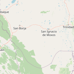
Map view of Parque Municipal y Área Natural de Manejo Integrado Gran Mojos

Use this park location map to pinpoint Parque Municipal y Área Natural de Manejo Integrado Gran Mojos in Bolivia, understand its exact geographic position, and read its mapped placement within the surrounding landscape more clearly.

Pigeon | © OpenStreetMap contributors

Location context for Parque Municipal y Área Natural de Manejo Integrado Gran Mojos

Beni
Park atlas

Compare surrounding floodplain reserves and connected conservation corridors across the Bolivian Beni.

Parks Near Parque Municipal y Área Natural de Manejo Integrado Gran Mojos and Regional Protected Areas

Browse nearby protected landscapes and wetland reserves adjacent to Parque Municipal y Área Natural de Manejo Integrado Gran Mojos. Evaluating connected lowland habitats reveals broader regional conservation patterns across the Mamoré River basin.
A watercolor painting showing a soft, atmospheric landscape with a winding river, green banks, trees, and distant low hills against a white background.
Protected areaBeni Department
About 26 km away#1 closest

Northwest

Área Protegida Municipal Ibare-Mamoré: Geography and Protected Area Context

Riverine landscapes and wetlands in Bolivia's Beni Department

The Área Protegida Municipal Ibare-Mamoré encompasses a diverse range of ecosystems, from upland forests to open grasslands and shifting river channels. As a key conservation unit near the city of Trinidad, this area highlights the ecological importance of the Llanos de Moxos region through its interconnected aquatic and terrestrial habitats.

Area
256.08 km²
Established
2011
Relief
Lowland
Climate
Tropical
Protected landscapeSanta Cruz
About 135 km away#2 closest

Southeast

Área Natural de Manejo Integrado Humedales del Norte Protected Landscape and Wetland Atlas

Mapping the floodplain ecosystems of northern Santa Cruz, Bolivia.

An extensive protected area in northern Santa Cruz that sustains vital Amazonian river systems and seasonal wetland mosaics. This landscape supports complex hydrological functions, including the regulation of climate and regional water cycles, through its vast network of periodically flooded forest tracts and permanent waterways.

Area
4,900.51 km²
Established
2012
Relief
Lowland
Scope
Terrestrial
Regional parkBeni
About 140 km away#3 closest

West

Parque regional Yacuma: Geographic Overview and Protected Landscape Mapping

Riparian ecosystems and flooded savanna terrain in Beni, Bolivia

Explore the expansive floodplain mosaic of Parque regional Yacuma, where the Yacuma and Beni river systems create a vital refuge for lowland wildlife. The park offers an essential view into the seasonal transitions of northern Bolivia, bridging pre-Andean forests and inundated savanna plains that define this significant regional conservation corridor.

Area
1,200 km²
Established
1990
Water
Major water bodies
National parkBolivia
About 160 km away#4 closest

Southwest

Isiboro Sécure National Park and Indigenous Territory: Bolivian Protected National Park Atlas

Mapped protected boundaries and regional landscape context.

Investigate Isiboro Sécure National Park and Indigenous Territory as a key protected national park within Bolivia's expansive geography. This resource offers detailed views of its mapped natural landscape and its regional significance as a protected area. Understand the park's geographic attributes and its contribution to the country's conservation atlas through structured map-based exploration.

Area
13,721.8 km²
Established
1965
IUCN
II
Relief
Mixed relief
A horizontal watercolor painting depicting a soft-focus landscape with green hills, a winding river, and reddish marshy foreground vegetation.
Biosphere reserveBolivia
About 177 km away#5 closest

Northwest

Reserva de Biosfera Estación Biológica del Beni: Protected Landscape and Geographic Atlas

Examining the Amazonian lowland mosaic of northern Bolivia

The Reserva de Biosfera Estación Biológica del Beni sits within the wide alluvial plains of the Llanos de Moxos. This protected area features a unique, flat terrain where tropical forest fragments persist as islands amidst seasonally flooded palm savannas, cyperaceous marshes, and shallow lagoons, providing a critical study area for Amazonian biodiversity.

Area
1,350 km²
Established
1982
Relief
Lowland
Climate
Tropical
Nature reserveBeni Department
About 214 km away#6 closest

Northwest

Reserva natural Barba Azul: A Protected Savanna Sanctuary in the Beni Department

Mapping flooded grasslands and gallery forest ecosystems

Reserva natural Barba Azul stands as a key protected area within the Bolivian Amazon lowlands. This nature reserve, centered in the Beni Department, preserves a rare mosaic of motacú palm forests and seasonal wetlands that serve as a critical stronghold for endangered parrots and migratory shorebirds within the larger Llanos de Moxos region.

Area
110 km²
Established
2008
Relief
Lowland
Climate
Tropical
National parkCochabamba Department
About 217 km away#7 closest

South

Carrasco National Park: National Park Status and Protected Landscape Geography

Explore mapped boundaries within Cochabamba Department.

Carrasco National Park, situated within the Cochabamba Department, represents a critical national park entity. This focus provides users with an atlas-centric view of its protected landscape, detailing its geographic significance and mapped features. Understand the park's terrain and regional context, offering a clear perspective on its conservation value and mapped presence.

Area
6,226 km²
Established
1991
IUCN
II
Relief
Mountain
Wildlife reserveSanta Cruz
About 248 km away#8 closest

East

Reserva de Vida Silvestre Ríos Blanco y Negro: Protected Area Geography and Landscape Map

Transitional lowland forests and river floodplains in Santa Cruz

The Reserva de Vida Silvestre Ríos Blanco y Negro protects a massive stretch of lowland forest in northeastern Bolivia. This area is characterized by its transitional ecology where dry forests meet the Amazon, shaped by the dynamic flooding of the San Pablo and Blanco rivers. Access this detailed geographic overview to understand the conservation significance and territorial extent of this critical wetland and forest environment.

Area
14,000 km²
Established
1990
Relief
Lowland
Climate
Tropical

Common questions about visiting, size, designation, and location context for Parque Municipal y Área Natural de Manejo Integrado Gran Mojos

Parque Municipal y Área Natural de Manejo Integrado Gran Mojos FAQs for park facts, access, geography, and protected area context

Find quick answers about Parque Municipal y Área Natural de Manejo Integrado Gran Mojos, including protected-area facts, park geography, trail and visitor context, and how the park fits into its surrounding country and regional landscape.
MoriAtlas Explorer

Continue Your Protected Areas Search Across the Global Atlas

Deepen your exploration by continuing the structured search for national parks and protected areas worldwide. Utilize the comprehensive filtering capabilities to compare different conservation landscapes and refine your understanding of global park geography. Discover more about the distribution and characteristics of protected natural areas.

Global natural geography