Mori Atlas logo
National parkParque Nacional Ciénagas del Catatumbo

Exploring the sprawling lowland marshes and riparian gallery forests of western Venezuela

Parque Nacional Ciénagas del Catatumbo: Mapped Wetland Landscapes and Regional Geography

Parque Nacional Ciénagas del Catatumbo encompasses a vast, flat wetland mosaic situated between the Serranía del Perijá and the Lake Maracaibo basin. This protected area preserves critical lowland riparian forests and expansive seasonally flooded grasslands at the mouth of the Catatumbo River. Beyond its water-dominated terrain, the region is recognized for the frequent atmospheric lightning discharges that define its unique environmental identity.

wetlandsmarshlandCatatumbo RiverLake Maracaibo basinSerranía del Perijátropical climate

Parque Nacional Ciénagas del Catatumbo

National park

Park overview

Structured park overview, official facts, and landscape profile for Parque Nacional Ciénagas del Catatumbo

Parque Nacional Ciénagas del Catatumbo park facts, protected area profile, and essential visitor context

Review the core facts for Parque Nacional Ciénagas del Catatumbo, including designation, size, terrain, visitor scale, habitats, and operating context in one park-focused overview.

About Parque Nacional Ciénagas del Catatumbo

Parque Nacional Ciénagas del Catatumbo stretches across a wide wetland corridor in the western Venezuelan state of Zulia, occupying the lowland platform between the Serranía del Perijá mountain range to the west and Lake Maracaibo to the east. The protected area sits at the delta-like outlet of the Catatumbo River, capturing the broad, shallow wetlands that form where the river system meets the lake basin. The park includes a small stretch of lakeshore in its southwestern section, extending its ecological influence into a transitional zone between freshwater marshes, flooded grasslands, and open lake waters.

The terrain is mostly flat, with no major elevations or notable topographic relief. Most of the landscape is dominated by expansive ciénagas, seasonally flooded plains of grasses and sedges, and shallow marsh basins that shift in extent with seasonal rainfall and river discharge. The climate is hot and intensely humid, and the air is typically thick with moisture rising from the saturated ground and open water. This atmosphere contributes to the swampy, sometimes hazy character of the protected area and is closely connected to the area's globally celebrated Catatumbo lightning, the persistent electrical discharges that occur over the marshlands and surrounding waters, particularly where the lake basin meets the wetland outwash.

Despite the relative ecological simplicity of the vegetation cover, the park protects the last relatively intact riparian forest remnants along the Catatumbo River, surviving as narrow strips of permanently flooded forest along the banks. These gallery woodlands are ecologically important because similar lowland river-forest formations have largely been lost elsewhere in Venezuela.

The park also holds logistical relevance at the regional scale. Near its boundaries lies Encontrados, a river port important as a transport node between the southwestern lake region and the broader national transportation network. This combination of ecological, atmospheric, and logistical context places Parque Nacional Ciénagas del Catatumbo as one of the defining protected landscapes of the Lake Maracaibo basin.

Quick facts and research context for Parque Nacional Ciénagas del Catatumbo

Parque Nacional Ciénagas del Catatumbo is a wetland-focused national park located in the state of Zulia in western Venezuela. It was established on 15 June 1991 and is classified as a IUCN Category II protected area.

The park is positioned in the lowlands between the Serranía del Perijá mountains and Lake Maracaibo, at the mouth of the Catatumbo River. Its defining setting is a broad, flat expanse of seasonally inundated plains and coastal wetland systems, with humid tropical temperatures year-round. The area is locally known under the alternate names Aguas Blancas y Aguas Negras and Ciénegas Juan Manuel.

Protection and recognition

Examine the terrestrial conservation framework and recognized protected status details.

Parque Nacional Ciénagas del Catatumbo Protection Status and Boundaries

Parque Nacional Ciénagas del Catatumbo maintains a defined terrestrial protection scope within regional conservation inventories. Official records compile available designation metrics and management parameters for geographic analysis.

Protection details

Protection scope
Terrestrial
Transboundary protection
No
Park context

Deeper park guide and search-rich context for Parque Nacional Ciénagas del Catatumbo

Parque Nacional Ciénagas del Catatumbo history, landscape, wildlife, and travel context

Explore Parque Nacional Ciénagas del Catatumbo through its history, landscape character, ecosystems, wildlife, conservation priorities, cultural context, and seasonal travel timing in a structured park guide built for atlas discovery and search intent.

Why Parque Nacional Ciénagas del Catatumbo stands out

The park is best known for two things: its enormous, flat freshwater marshlands at the Catatumbo River outlet, and as part of the broader region where the Catatumbo lightning phenomenon occurs. This atmospheric display, frequent and unusually powerful electric discharges that fall over the wetland plain without producing thunder, gives the surrounding landscape a near-mythic character in Venezuela. Ecologically, the park is also recognized for hosting rich aquatic avifauna, with visible populations of white herons, blue herons, jabiru storks, ducks, gulls, terns, and local raptors known as caracaras. The surviving strips of permanently flooded riparian forest along the Catatumbo River represent some of the last intact lowland gallery forest formations in Venezuela, adding to the park's environmental value.

A night landscape view showing a bright lightning bolt striking the horizon above a calm dark body of water with stilt houses silhouetted in the distance.
The famous Catatumbo lightning phenomenon over the wetlands of Ciénagas del Catatumbo National Park.

Parque Nacional Ciénagas del Catatumbo history and protected-area timeline

Parque Nacional Ciénagas del Catatumbo was officially established as a national park on 15 June 1991, becoming the second national-level protected area in the state of Zulia. Its creation reflects the recognition of both the ecological and geographic importance of the extensive marshlands at the mouth of the Catatumbo River, one of the most prominent lowland wetland complexes in western Venezuela.

The protected area was designated under IUCN Category II classification, the standard category for national parks, signaling an intent to preserve its natural and scenic character at a national level. Beyond its formal protection status, the surrounding wetland region has long held cultural and atmospheric significance locally, particularly due to the Catatumbo lightning phenomenon that has historically drawn attention to the marshlands.

Parque Nacional Ciénagas del Catatumbo landscape and geographic character

The landscape of Parque Nacional Ciénagas del Catatumbo is overwhelmingly flat and water-dominated. The protected area occupies the broad lowland plain at the southern end of Lake Maracaibo, between the western foothills of the Serranía del Perijá and the lake basin. There are no notable peaks, ridges, or strong elevation gradients within the park; instead, the elevation remains consistently low across its territory.

The defining surface features are expansive marshlands, locally referred to as ciénagas. These wetlands are highly dynamic, expanding and contracting with seasonal rainfall and the discharge of the Catatumbo River. The terrain is largely composed of seasonally flooded grasslands, herbaceous marsh vegetation, and shallow standing water bodies, in some places with more permanent pools.

Along the edges of the Catatumbo River, narrow strips of permanently flooded riparian forest survive as gallery woodlands, representing some of the more visually diverse portions of the landscape. These forested bands are relatively modest in extent but contrast sharply with the open marsh around them. In the southwestern segment of the park, a small stretch of Lake Maracaibo shoreline adds a marginal lacustrine character, where the marsh landscape gradually opens into the lake's waters.

Beyond the park itself, the surrounding landscape includes the broader llanos of western Zulia, the lake basin, and the elevated uplands of the Serranía del Perijá, all of which frame the wetland mosaic. The atmospheric character of the area, including the frequent lightning discharges over the marshes, is also part of the broader landscape experience of this region.

Parque Nacional Ciénagas del Catatumbo ecosystems, habitats, and plant life

The natural environment of Parque Nacional Ciénagas del Catatumbo is shaped by extensive freshwater wetland systems at the mouth of one of Venezuela's principal western rivers. The dominant ecological character is marshland and seasonally flooded grassland, with the herbaceous vegetation layer covering most of the territory. The area is essentially a large, dynamic ciénaga, where water levels rise and fall according to river discharge and seasonal rainfall, creating a shifting mosaic of shallow pools, saturated herbaceous flats, and wet meadows.

The most ecologically distinctive vegetation component is the narrow remnant riparian forest that survives along the banks of the Catatumbo River. These strips of permanently flooded forest are described as among the last intact lowland gallery forest formations remaining in Venezuela and hold disproportionate conservation value relative to their limited extent.

The aquatic systems, including the woven network of marsh channels, river outlets, and Lake Maracaibo margins, form the core of the park's ecological identity. The combination of open water, marsh vegetation, flooded grasslands, and small surviving forest patches creates a wetland mosaic that supports high densities of waterbirds and aquatic fauna.

Parque Nacional Ciénagas del Catatumbo wildlife and species highlights

Wildlife within Parque Nacional Ciénagas del Catatumbo is dominated by aquatic species, especially birds. The marshlands and shallow open water support abundant populations of waterbirds, with visible species including white herons, blue herons, and the jabiru stork, locally known as garzón soldado. Ducks, gulls, and terns are also commonly observed across the wetlands, contributing to a varied and conspicuous avifauna.

Predatory birds form another important component of the wildlife profile. The park supports populations of local raptors known as caracaras, which patrol the marsh edges and open country in search of prey. The mix of wading birds, waterfowl, seabirds, and raptors gives the area a bird-rich, fairly active animal presence throughout the wetland habitats.

Although the wildlife profile is recognized as biologically rich, no scientifically structured fauna census has been conducted in the park. The wildlife picture is therefore largely qualitative, based on visible species patterns and local observations, rather than on formal population inventories. The aquatic fauna in general is described as abundant, suggesting that the marsh and river systems continue to support significant populations of fish and other aquatic organisms, even without complete scientific documentation.

Parque Nacional Ciénagas del Catatumbo conservation status and protection priorities

From a conservation standpoint, Parque Nacional Ciénagas del Catatumbo holds particular importance for the protection of western Venezuelan wetlands. The park preserves a major portion of the country's lowland marshland habitat at the outlet of the Catatumbo River, an ecological transition zone that would otherwise face significant pressure from drainage, sedimentation, and land-use changes common in tropical wetland regions.

The remnant riparian forests along the Catatumbo River are perhaps the most important conservation focus within the park. These gallery forests are described as some of the last intact lowland riverine forest formations in Venezuela, making them disproportionately valuable for biodiversity and ecological continuity. Their protection within the park's boundary shields them from the wider pressures affecting similar habitats outside the protected area.

The park's IUCN Category II national park designation reflects an intent to maintain its ecological, scenic, and scientific value at a national level. Beyond specific species or habitat features, the park also contributes to preserving the broader hydrological and ecological functioning of the Lake Maracaibo basin, given its position at the wetland headlands of the lake system.

Parque Nacional Ciénagas del Catatumbo cultural meaning and human context

The region surrounding Parque Nacional Ciénagas del Catatumbo carries significant cultural and regional identity, particularly due to the local fame of the Catatumbo lightning. This atmospheric phenomenon, in which unusually frequent electrical discharges occur over the wetlands, frequently without audible thunder, has become an iconic element of the area's identity and is closely tied to the visual and cultural experience of the region.

Locally, the wetland landscape is known by additional names, including Aguas Blancas y Aguas Negras and Ciénegas Juan Manuel, names that reflect how local communities have long identified and partitioned these marsh systems. Near the park lies Encontrados, a key river port that serves as a logistical hub for the southwestern lake region of Venezuela. The presence of such a transport node connects the park's otherwise remote marshland setting to broader regional life and infrastructure.

Top sights and standout views in Parque Nacional Ciénagas del Catatumbo

Among the park's most distinctive qualities are the vast, unbroken expanses of lowland marsh and seasonally flooded plains that define its landscape, and the presence of the Catatumbo lightning phenomenon, which gives the area a near-unique atmospheric character. The park is also notable for protecting some of the last intact lowland riparian forests along the Catatumbo River, an ecologically valuable remnant that elevates the park's conservation significance beyond its herbaceous marshlands.

Best time to visit Parque Nacional Ciénagas del Catatumbo

Parque Nacional Ciénagas del Catatumbo lies in a hot and consistently humid tropical climate, with temperatures typically ranging from the low twenties into the low thirties Celsius. Year-round humidity is very high, and seasonal differences are governed primarily by variations in rainfall and river discharge, which in turn shape the extent of flooded marshland.

Periods of lower water levels tend to make the marshland landscape more accessible for shallow exploration and offer clearer conditions for observing wading birds and raptors concentrated along wetland margins. Wetter periods expand the flooded zones but may also heighten the atmosphere associated with the Catatumbo lightning, which is typically most dramatic during specific seasonal windows when atmospheric conditions over the lake basin and wetlands align.

Monthly climate preview

Long-term representative temperature and precipitation patterns across the year

Parque Nacional Ciénagas del Catatumbo Climate Normals And Weather By Month

Representative coordinate records show sustained monthly warmth alongside shifting precipitation rates throughout the annual cycle at Parque Nacional Ciénagas del Catatumbo. Examining the complete twelve-month climate profile reveals precise long-term temperature and precipitation averages for this protected area.
Annual mean29 °C
28 °C30 °C
Jan28°
Feb29°
Mar30°
Apr30°
May30°
Jun30°
Jul30°
Aug30°
Sep29°
Oct28°
Nov28°
Dec28°
Warmest month
August

30.4 °C

Coolest month
November

27.6 °C

Wettest month
October

4.3 mm/day

Driest month
January

0.8 mm/day

Park location guide

Geography guide, regional context, and park location map for Parque Nacional Ciénagas del Catatumbo

Parque Nacional Ciénagas del Catatumbo park geography, regions, and map view in Venezuela

Understand where Parque Nacional Ciénagas del Catatumbo sits in Venezuela through a broader geographic reading of the surrounding landscape, nearby location context, and its mapped position within the national park landscape.

How Parque Nacional Ciénagas del Catatumbo fits into Venezuela

Venezuela is a country in northern South America with coastline along the Caribbean Sea and Atlantic Ocean. It borders Colombia, Brazil, Guyana, and Trinidad and Tobago. The country has an area of approximately 916,445 km² and a population of about 31.8 million. Caracas is the capital and largest city. Venezuela consists of 23 states and the Capital District.

Wider geography shaping Parque Nacional Ciénagas del Catatumbo in Venezuela

Venezuela is located on the northern coast of South America. The continental territory is bordered by the Caribbean Sea and Atlantic Ocean to the north, Colombia to the west, Brazil to the south, and Guyana to the east. Trinidad and Tobago lies to the northeast. The country includes various islands and islets in the Caribbean Sea known as the Federal Dependencies.

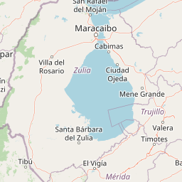
Map view of Parque Nacional Ciénagas del Catatumbo

Use this park location map to pinpoint Parque Nacional Ciénagas del Catatumbo in Venezuela, understand its exact geographic position, and read its mapped placement within the surrounding landscape more clearly.

Pigeon | © OpenStreetMap contributors

Location context for Parque Nacional Ciénagas del Catatumbo

Zulia

Visual reference guide for wetland habitats, river deltas, and protected lowland terrain

Parque Nacional Ciénagas del Catatumbo Photos, Landscapes, and Scenery

Explore high-resolution park photography documenting the expansive freshwater marshes, flooded grasslands, and gallery forests of western Venezuela. Visual documentation reveals the distinct lowland geography and wetland habitats that define the protected landscape.

A night landscape view showing a bright lightning bolt striking the horizon above a calm dark body of water with stilt houses silhouetted in the distance.

Park atlas

Compare regional wetland reserves, river basin ecosystems, and adjacent highland park geography.

Other Parks Near Parque Nacional Ciénagas del Catatumbo and Surrounding Protected Landscapes

Browsing other parks near Parque Nacional Ciénagas del Catatumbo reveals connected lowland plains, river basins, and wetland reserves across western Zulia. Extending the geographic comparison helps trace broader protected landscapes and regional topography beyond the Lake Maracaibo basin.
National parkVenezuela
About 0.7 km away#1 closest

Southeast

Ciénagas del Catatumbo National Park: Venezuela's Freshwater Marsh Protected Landscape

Mapped wetland geography and diverse tropical savanna ecosystems.

Ciénagas del Catatumbo National Park is a vital protected area safeguarding extensive marshland and savanna ecosystems in northwestern Venezuela, specifically within the Lake Maracaibo basin. This national park is recognized for its significant freshwater marsh complex, which supports a rich diversity of bird species and plays a crucial role in the watershed's ecological health. Exploring this park offers a focused discovery of tropical wetland geography and protected landscape features.

IUCN
II
Water
Major water bodies
National parkVenezuela
About 75 km away#2 closest

West

Sierra de Perijá National Park: Protected Area in Venezuela's Geographic Atlas

Explore its national park boundaries and regional landscape context.

Sierra de Perijá National Park is a designated national park in Venezuela, representing a significant protected landscape within the country. This entry facilitates detailed atlas exploration, allowing users to understand the park's precise geographic scope, its mapped boundaries, and its connection to the surrounding regional geography. Discover the core identity of this protected area and its value for geographic study and mapped landscape analysis.

Area
2,952.88 km²
Established
1978
IUCN
II
Relief
Mountain
National parkVenezuela
About 130 km away#3 closest

Southeast

Sierra La Culata National Park: Protected Landscape Atlas of the Venezuelan Andes

Explore the páramo ecosystems and mapped terrain of this Venezuelan national park.

Sierra La Culata National Park offers a profound look into the unique geography of the Venezuelan Andes. This protected national park is characterized by its expansive páramo ecosystems, dramatic mountain peaks, and glacial lagoons, creating a distinctive high-altitude wilderness. Use this atlas-focused entry to understand the park's mapped boundaries and its significant role within the region's natural landscape context.

Area
2,004 km²
Established
1989
IUCN
II
Relief
Mountain
Natural monumentMérida
About 141 km away#4 closest

Southeast

Monumento natural Meseta la Galera: Protected Andean Plateau and Geography Map

Analyzing the fluvial terrain and forest landscape of Tovar, Merida.

Monumento natural Meseta la Galera serves as a vital geographic landmark near Tovar, Merida. This protected natural monument preserves a rare flat topped plateau rising over the Mocoties River valley. Examine the structured map context of this 95 hectare forest refuge and its defined topographical boundaries within the Andean mountain foothills.

Area
0.95 km²
Established
1992
IUCN
III
Relief
Highland
A soft watercolor painting of a calm lake surrounded by lush green vegetation with distant, hazy mountains under a pale sky.
Natural monumentMérida
About 151 km away#5 closest

Southeast

Laguna de Urao Natural Monument: Geographic Profile and Protected Andean Landscape

Saline tectonic lake located in the Mérida region of Venezuela

Laguna de Urao is a singular protected natural feature of tectonic origin situated in the semi-arid Andean landscape of Mérida. Known for the accumulation of the urao mineral, this saline water body serves as an important geographic landmark that anchors the cultural and geological identity of the local surroundings.

Established
1979
Relief
Upland
Water
Major water bodies
Watercolor painting showing green hills, a river, and distant mountains under a light sky
National parkVenezuela
About 159 km away#6 closest

Southeast

Sierra Nevada National Park: Venezuela's Majestic Alpine Protected Landscape and Park Boundaries

Explore the highest peaks and glacial terrain of this Venezuelan national park.

Delve into Sierra Nevada National Park, a premier protected area situated in the high Venezuelan Andes. This national park protects a vast expanse of dramatic alpine terrain, including Pico Bolívar and numerous glacial valleys. Understand its mapped boundaries and the unique paramo and cloud forest ecosystems that define this significant natural landscape within Venezuela, offering rich context for atlas-style geographic discovery.

Area
2,764.46 km²
Established
1952
IUCN
II
Relief
Mountain
Natural monumentColombia
About 171 km away#7 closest

Southwest

Los Estoraques Unique Natural Area: Colombian Natural Monument of Eroded Pillars

Geographic Context and Landscape Atlas

Los Estoraques Unique Natural Area stands as a distinctive protected landscape within Colombia's Norte de Santander Department. This natural monument is renowned for its striking geological formations of eroded brownstone columns and pedestals, a unique erosional terrain set within the Andean foothills. The area's mapped boundaries encompass a complex ecosystem, bridging dry forest and cloud forest zones, offering significant value for understanding regional geography and the distribution of protected lands in South America.

Area
562 km²
Established
1988
IUCN
III
Relief
Mountain
Wildlife reserveEstado Zulia
About 174 km away#8 closest

Northeast

Ciénaga de Los Olivitos: Geographic Profile of a Coastal Wetland Wildlife Reserve

Explore tidal mangrove systems and lagoon habitats in Estado Zulia.

Ciénaga de Los Olivitos serves as a major coastal refuge, defined by its extensive network of saline lagoons, tidal mangrove channels, and sandy beaches. Recognized for its international ecological importance, this protected landscape provides a detailed look at the water-rich topography of the western Venezuelan coast. Examine the structural components of this marshy terrain and its role within the broader regional geography of the Lake Maracaibo basin.

Area
260 km²
Established
1996
IUCN
Ib
Relief
Lowland

Common questions about visiting, size, designation, and location context for Parque Nacional Ciénagas del Catatumbo

Parque Nacional Ciénagas del Catatumbo FAQs for park facts, access, geography, and protected area context

Find quick answers about Parque Nacional Ciénagas del Catatumbo, including protected-area facts, park geography, trail and visitor context, and how the park fits into its surrounding country and regional landscape.
MoriAtlas Explorer

Continue Your Protected Areas Search Across the Global Atlas

Deepen your exploration by continuing the structured search for national parks and protected areas worldwide. Utilize the comprehensive filtering capabilities to compare different conservation landscapes and refine your understanding of global park geography. Discover more about the distribution and characteristics of protected natural areas.

Global natural geography