Mori Atlas logo
National parkPeriyar National Park

Discover mapped protected areas, natural terrain, and landscape context for this key national park.

Periyar National Park: India's Protected Landscape and Regional Geography in Kerala

(Periyar National Park and Wildlife Sanctuary)

Periyar National Park stands as a significant protected area within the diverse geography of Kerala, India. This page offers an atlas-oriented view, detailing the park's mapped boundaries and its role as a protected landscape. Understand the natural terrain and regional context that defines Periyar National Park, providing a foundation for structured geographic discovery.

Tiger ReserveElephant HabitatWestern GhatsMountain ForestsNational ParkWildlife Sanctuary

Periyar National Park

National park

Park overview

Structured park overview, official facts, and landscape profile for Periyar National Park

Periyar National Park park facts, protected area profile, and essential visitor context

Review the core facts for Periyar National Park, including designation, size, terrain, visitor scale, habitats, and operating context in one park-focused overview.

About Periyar National Park

Periyar National Park occupies a mountainous region in the southern Western Ghats, specifically within the Cardamom Hills and Pandalam Hills of Kerala state. The protected area surrounds Periyar Lake, an artificial reservoir spanning 31 square kilometers that was formed when the Mullaperiyar Dam was constructed in 1895. The lake and the Periyar River meander through contours of heavily wooded hills, providing permanent water sources that sustain the park's diverse wildlife. The park's topography features both steep and rolling terrain covered in thick forest vegetation. Eastern boundaries follow interstate ridges with peaks exceeding 1,700 meters, while the western section includes a 1,200-meter high plateau before dropping to the 100-meter valley of the Pamba River. Kottamala at 2,019 meters is the highest peak within the reserve. The park is situated approximately 4 kilometers from Kumily and Thekkady, making it accessible for tourism while maintaining its protected character.

Quick facts and research context for Periyar National Park

Periyar National Park covers 350.54 square kilometers as its core national park zone, with the broader protected area spanning 925 square kilometers. Located in Kerala's Idukki and Pathanamthitta districts along the Tamil Nadu border, the park sits in the Cardamom and Pandalam Hills of the Western Ghats. The reserve was established as a wildlife sanctuary in 1950 after being declared a private reserve by the Maharaja of Travancore in 1934, later joining Project Tiger in 1978 and Project Elephant in 1991. The park recorded 754,306 visitors in 2016 and is governed by the Kerala Forest and Wildlife Department.

Protection and recognition

Documenting the official management framework and protected area scope within the global database

Periyar National Park Protection Status and Conservation Designation

Researchers can examine the official protection status and documented conservation boundaries established for Periyar National Park. Understanding these structured designations helps clarify how the mixed management scope operates within regional and national frameworks.

Protection details

Protection scope
Mixed
Transboundary protection
No
Park context

Deeper park guide and search-rich context for Periyar National Park

Periyar National Park history, landscape, wildlife, and travel context

Explore Periyar National Park through its history, landscape character, ecosystems, wildlife, conservation priorities, cultural context, and seasonal travel timing in a structured park guide built for atlas discovery and search intent.

Why Periyar National Park stands out

Periyar is renowned as a premier tiger and elephant habitat within the Western Ghats, one of the world's eight biodiversity hotspots. The park protects critical elephant corridors and serves as a vital watershed for Kerala's major rivers. Its reputation as Periyar Tiger Reserve stems from successful conservation of both Bengal tigers and Asian elephants, with occasional sightings of white tigers. The park's dramatic landscape of misty hills, the reservoir lake, and dense evergreen forests creates one of India's most scenic protected landscapes.

Periyar National Park history and protected-area timeline

The conservation history of Periyar began in 1934 when the Maharaja of Travancore, Chithira Thirunal Balarama Varma, declared the forests surrounding Periyar Lake a private reserve to prevent encroachment by tea plantations. This area was initially known as Nellikkampatty Reserve. After India's political integration in 1950, the reserve was consolidated as a wildlife sanctuary. The sanctuary joined Project Tiger in 1978, receiving formal designation as Periyar Tiger Reserve. In 1982, the core area of 350.54 square kilometers was declared a national park. Further expansion occurred in 2007 when 148 square kilometers of the Goodrical Range were added, followed by additional evergreen forest at Ponnambalamedu in 2012. The park was brought under Project Elephant in 1991 and assessed as having "very good" management by India's National Tiger Conservation Authority in 2011.

Periyar National Park landscape and geographic character

The park sits within the Cardamom Hills, a mountainous region characterized by steep and rolling terrain thickly covered with forest. The landscape transitions from high ridges exceeding 1,700 meters along the eastern boundary to a 1,200-meter plateau in the western section before descending into the deep Pamba River valley at around 100 meters elevation. The most prominent peak is Kottamala at 2,019 meters, notable as the southernmost peak in India above 2,000 meters. Other significant peaks include Pachayarmala, Vellimala, Sunderamala, Chokkampetti mala, and Karimala. Periyar Lake dominates the lower terrain, its undulating shoreline winding around forested hillsides. The surrounding landscape includes plantations of tea, cardamom, and coffee in lower elevation zones.

Periyar National Park ecosystems, habitats, and plant life

Periyar supports tropical and subtropical moist broadleaf forests, montane grasslands and shrublands, montane savannas, eucalyptus plantations, wetlands, and lake ecosystems. A total of 1,965 flowering plant taxa have been documented, including 171 grass species and 140 orchid species. Seventeen plant taxa are possibly extinct. Forest composition includes deciduous, evergreen, and semi-evergreen species such as teak, rosewoods, terminalia, sandalwoods, mango, jamun, tamarind, banyan, sacred fig, and bamboo. The park contains the only south Indian conifer, Nageia wallichiana. Endemic flora includes Habenaria periyarensis and Syzygium periyarense. The medicinal gloriosa lily also grows within the reserve. These diverse habitats provide the ecological foundation for the park's significant wildlife populations.

Periyar National Park wildlife and species highlights

The park supports 35 mammal species including significant populations of Bengal tigers (approximately 40 individuals counted in 2017) and Asian elephants. Other notable mammals include gaur, sambar deer, wild pig, Indian giant squirrel, Travancore flying squirrel, jungle cat, dhole, sloth bear, Nilgiri tahr, lion-tailed macaque, Nilgiri langur, and Nilgiri marten. Bird diversity includes about 266 species, with endemic varieties such as the Malabar grey hornbill, Nilgiri wood pigeon, blue-winged parakeet, Nilgiri flycatcher, and black-necked stork. The park harbors 45 reptile species including king cobra, Malabar pit viper, and striped coral snake. Amphibians include the Malabar gliding frog and bicolored frog. Approximately 40 fish species inhabit the lake and rivers, including endemic species like Periyar trout, Periyar latia, and Periyar barb. Insect diversity includes roughly 160 butterfly taxa, with the southern birdwing being South India's largest butterfly.

Periyar National Park conservation status and protection priorities

Periyar holds significant conservation value as part of the Western Ghats, recognized as a global biodiversity hotspot. The reserve provides critical habitat for endangered species including Bengal tigers and Asian elephants, both benefiting from dedicated government conservation projects. The ecosystem generates substantial benefits valued at approximately 17.6 billion rupees annually, including gene-pool protection, water provisioning to Tamil Nadu districts, wildlife habitat services, and recreation value. The park serves as a crucial watershed, with both the Periyar and Pamba Rivers originating within its boundaries, supplying water to downstream regions. Its designation as both a Project Tiger and Project Elephant reserve reflects its national importance for large mammal conservation.

Periyar National Park cultural meaning and human context

The region around Periyar was historically part of the princely state of Travancore, with the maharaja's decision in 1934 to establish the private reserve representing an early conservation initiative in Kerala. The reserve surrounds Periyar Lake, whose creation through the Mullaperiyar Dam in 1895 reflects human modification of the landscape. Local communities inhabit areas surrounding the park, with agricultural plantations of tea, cardamom, and coffee occupying lower elevations. The park's proximity to Kumily and Thekkady creates opportunities for community-based tourism and employment generation, with the reserve providing approximately 25 million rupees in annual employment benefits to local populations.

Top sights and standout views in Periyar National Park

Periyar offers a rare combination of significant tiger and elephant populations within a scenic Western Ghats landscape. The reservoir lake with its submerged trees creates a distinctive visual character unlike other Indian parks. The park's elevation range from 100 to 2,019 meters supports exceptional biodiversity across multiple habitat types. Endemic species including the lion-tailed macaque, Nilgiri tahr, and numerous Western Ghats-restricted birds and butterflies add scientific value to the tourism experience. The Periyar River's role as a major watershed for Kerala underscores the park's importance beyond wildlife conservation.

Best time to visit Periyar National Park

The park experiences a tropical highland climate with temperatures ranging from 15 degrees Celsius in December and January to 31 degrees Celsius in April and May. Annual rainfall averages between 2,000 and 3,000 millimeters, with approximately two-thirds falling during the southwest monsoon from June to September. The northeast monsoon brings additional rainfall between October and December. The winter months from November to February offer pleasant temperatures and clearer visibility for wildlife viewing, though the monsoon season creates lush green landscapes. Summer months can be warm but still provide good opportunities to observe animals at the lake's water sources.

Monthly climate preview

Long term temperature and precipitation normals for the protected Kerala highlands

Periyar National Park Climate and Historical Monthly Weather Patterns

Long term records from a representative elevation of 420 meters reveal a climate cycle with warm spring peaks, heavy monsoonal precipitation peaking in June, and dry winters. Accessing the complete monthly climate normals for Periyar National Park provides detailed historical figures for average temperatures, daily rainfall rhythms, and annual shifts.
Annual mean25 °C
23 °C27 °C
Jan23°
Feb25°
Mar27°
Apr27°
May26°
Jun24°
Jul24°
Aug23°
Sep24°
Oct24°
Nov24°
Dec23°
Warmest month
April

27.3 °C

Coolest month
December

22.8 °C

Wettest month
June

13.3 mm/day

Driest month
January

0.6 mm/day

Park location guide

Geography guide, regional context, and park location map for Periyar National Park

Periyar National Park park geography, regions, and map view in India

Understand where Periyar National Park sits in India through a broader geographic reading of the surrounding landscape, nearby location context, and its mapped position within the national park landscape.

How Periyar National Park fits into India

India is a South Asian country bordered by the Indian Ocean, Arabian Sea, and Bay of Bengal. It shares land borders with Pakistan, China, Nepal, Bhutan, Bangladesh, and Myanmar. The country has a population of over 1.4 billion people and operates as a federal parliamentary republic with its capital in New Delhi.

Wider geography shaping Periyar National Park in India

India occupies the Indian subcontinent in South Asia, bordered by the Arabian Sea to the southwest, the Bay of Bengal to the southeast, and the Indian Ocean to the south. It shares land borders with Pakistan to the west, China, Nepal, and Bhutan to the north, and Bangladesh and Myanmar to the east. The territory also includes the Andaman and Nicobar Islands in the Indian Ocean.

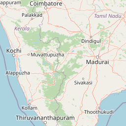
Map view of Periyar National Park

Use this park location map to pinpoint Periyar National Park in India, understand its exact geographic position, and read its mapped placement within the surrounding landscape more clearly.

Pigeon | © OpenStreetMap contributors

Location context for Periyar National Park

IdukkiKeralaPathanamthitta
Park atlas

Browse an expanded atlas of conservation landscapes and mapped park geography across the broader Western Ghats region.

National Parks and Protected Areas Around Periyar National Park in the Western Ghats

Explore a curated selection of national parks and protected areas located near Periyar National Park, tracing a wider network of conservation landscapes within the Western Ghats of southern India. This geographic context enables users to compare diverse protected habitats, understand regional ecological connections, and continue atlas-style discovery across similar mountainous and forest ecosystems.
National parkIdukki
About 51 km away#1 closest

North

Mathikettan Shola National Park: National Park Exploration and Geographic Mapping

Discover its protected landscape and regional context.

Mathikettan Shola National Park, a designated national park in the Idukki region, offers a focal point for understanding protected landscapes and their geographic distribution. This entry details the park's mapped boundaries and its specific setting within the regional geography, providing an atlas-level view of its conservation value. Users can explore the structured geographic identity of this protected natural area, enriching their understanding of India's park network.

Area
12.82 km²
Established
2003
IUCN
II
Relief
Mountain
National parkIndia
About 63 km away#2 closest

North

Pampadum Shola National Park: India's Protected Area Landscape Details

Explore mapped terrain and geographic context for this national park.

Gain insight into Pampadum Shola National Park, a key protected area within India's geography. This park detail provides essential information on its designation as a national park, its mapped boundaries, and its contribution to the regional landscape. It serves as a vital point for understanding the distribution and character of protected lands across India, offering a foundation for structured geographic research and atlas-based discovery of natural environments.

National parkKerala
About 64 km away#3 closest

North

Eravikulam National Park: National Park with Mapped Protected Boundaries in Kerala

Understanding its geographic setting and landscape identity.

Delve into the protected landscape of Eravikulam National Park, a significant national park located in Kerala. This detailed entry focuses on its geographic coordinates, mapped boundaries, and its role as a distinct protected area within the regional geography. It serves as a valuable resource for exploring the park's natural terrain and its importance in conservation landscapes.

Area
97 km²
Established
1978
IUCN
II
Visitors
148.4K annual
National parkKerala
About 65 km away#4 closest

North

Anamudi Shola National Park: Protected Montane Forest and Wildlife Corridor in Kerala

Explore unique high-altitude ecosystems and regional landscape context.

Anamudi Shola National Park is a compact yet ecologically significant protected area situated in the Western Ghats of Kerala, India. Covering around 7.5 square kilometers, the park preserves rare montane shola forests at elevations exceeding 2,100 meters. Its identity as a critical wildlife corridor, connecting contiguous protected zones, is fundamental to its conservation value. The park's landscape, defined by its unique ecosystems and regional geographic position, offers valuable insights for atlas-driven exploration of protected natural areas.

Area
7.5 km²
Established
2003
IUCN
II
Relief
Mountain
Protected areaKerala
About 85 km away#5 closest

Southwest

Sasthamkotta Lake Protected Area: Geography and Wetland Map Profile

Kerala's largest freshwater wetland and basin landscape

Investigate the territorial profile of Sasthamkotta Lake, an important Ramsar site in Kerala. This resource maps the lake's sheltered basin, shoreline hill contours, and connection to the alluvial plains of the Kallada River, highlighting its critical role in the regional hydrologic network.

Area
3.73 km²
Relief
Lowland
Climate
Tropical
Access
Easy access
Wildlife reserveIndia
About 94 km away#6 closest

North

Anaimalai Tiger Reserve: Wildlife Reserve Park Atlas and Geographic Context in India

Mapping protected landscapes and natural terrain of this Indian wildlife reserve.

Anaimalai Tiger Reserve is a significant wildlife reserve located in India, offering rich opportunities for geographic and atlas-based discovery. This page provides detailed information on its protected area status, mapped boundaries, and the surrounding natural landscape context. Delve into the park's specific geography to understand its role as a conservation area within the broader Indian subcontinent.

Wildlife reserveKerala
About 94 km away#7 closest

Southwest

Ashtamudi Lake Wildlife Reserve: Geographic Atlas of Kerala Wetland Systems

Mapping the eight-armed estuary and coastal wetland landscape

Ashtamudi Lake is a major estuarine system in Kerala, defined by its branching topography and significant tidal influence. This atlas entry provides a clear perspective on the park's protected boundaries, including its mangrove patches, inland navigation channels, and island clusters that form the core of the regional wetland geography.

Area
61.4 km²
Established
2002
Visitors
25K annual
Relief
Lowland
Protected areaIndia
About 96 km away#8 closest

West

Vembanad Protected Area: Mapping India's Iconic Kerala Backwaters and Wetland Landscape

An extensive inland lake system featuring tidal lagoons, islets, and below-sea-level agricultural plains.

Spanning over 96 kilometers, Vembanad forms a sprawling wetland environment that acts as the primary drainage basin for much of Kerala. Analyze the geography of its intricate shorelines, mangrove patches, and historic islets like Pathiramanal. This protected zone provides a critical habitat for thousands of waterbirds while illustrating the complex relationship between coastal estuaries and human-managed landscapes.

Area
2,033.02 km²
Relief
Lowland
Climate
Tropical
Access
Easy access

Common questions about visiting, size, designation, and location context for Periyar National Park

Periyar National Park FAQs for park facts, access, geography, and protected area context

Find quick answers about Periyar National Park, including protected-area facts, park geography, trail and visitor context, and how the park fits into its surrounding country and regional landscape.
MoriAtlas Explorer

Continue Your Protected Areas Search Across the Global Atlas

Deepen your exploration by continuing the structured search for national parks and protected areas worldwide. Utilize the comprehensive filtering capabilities to compare different conservation landscapes and refine your understanding of global park geography. Discover more about the distribution and characteristics of protected natural areas.

Global natural geography