Mori Atlas logo
National parkEravikulam National Park

Mapping the protected boundaries and regional context of this national park.

Eravikulam National Park: Protected Landscape and Geographic Atlas in Kerala

Eravikulam National Park represents a significant protected natural area within the Indian state of Kerala. As a designated national park, its boundaries are crucial for understanding the region's protected lands. This entry provides detailed geographic context, enabling atlas-style exploration of its terrain and its place within the broader landscape of Kerala, highlighting its identity as a key conservation area.

National ParkWestern GhatsMontane GrasslandShola ForestEndangered SpeciesNilgiri Tahr

Eravikulam National Park

National park

Park overview

Structured park overview, official facts, and landscape profile for Eravikulam National Park

Eravikulam National Park park facts, protected area profile, and essential visitor context
Review the core facts for Eravikulam National Park, including designation, size, terrain, visitor scale, habitats, and operating context in one park-focused overview.

About Eravikulam National Park

Eravikulam National Park occupies a prominent position in the Western Ghats, one of the world's eight most important biodiversity hotspots. The park's high-altitude setting, with terrain above 2,000 meters, supports a rare combination of montane grasslands and shola forests that characterizes this mountain ecosystem. Anamudi, the highest peak in South India at 2,695 meters, rises dramatically within the park's boundaries, offering spectacular views across the rolling plateau. The park's location along the Western Ghats places it at a critical juncture for species migration and ecological processes, while its relatively intact habitats provide essential refuge for numerous endemic species. The drainage pattern within the park features perennial streams that eventually join major river systems on both sides of the Ghats, feeding the Periyar River to the west and the Cauvery River to the east. Dense forest areas like Pooyamkutty and Idamalayar border the park to the northwest, extending the protected landscape beyond the national park's official boundaries.

Quick facts and research context for Eravikulam National Park

Eravikulam National Park spans 97 square kilometers along the Western Ghats in Kerala, India, at elevations ranging from roughly 2,000 to 2,695 meters. The protected area was established in 1978 as Kerala's first national park, administered by the Kerala Department of Forests and Wildlife through the Munnar Wildlife Division. The landscape features a rolling plateau with grasslands and shola forests, while perennial streams within the park feed tributaries of both the Periyar River to the west and the Cauvery River to the east.

Park context

Deeper park guide and search-rich context for Eravikulam National Park

Eravikulam National Park history, landscape, wildlife, and travel context
Explore Eravikulam National Park through its history, landscape character, ecosystems, wildlife, conservation priorities, cultural context, and seasonal travel timing in a structured park guide built for atlas discovery and search intent.

Why Eravikulam National Park stands out

Eravikulam National Park is best known for protecting the largest regional population of the endangered Nilgiri tahr, a rare highland ungulate endemic to the Western Ghats. The park also encompasses Anamudi, the highest peak in South India, making it a significant location for montane ecosystem conservation. The park's shola-grassland ecosystem supports exceptional biodiversity, including numerous endemic bird species and amphibians. The periodic bloom of neelakurinji, a flowering plant that carpets the hills in blue-purple hues, adds further distinction to this highland sanctuary.

Eravikulam National Park history and protected-area timeline

Prior to 1971, the Eravikulam area was managed as a game preserve by the Kanan Devan Hills Produce Company, which controlled large tea plantations in the region. The Government of Kerala resumed control of these lands in 1971 through the Kannan Devan Hill Produce (Resumption of lands) Act. Recognizing the ecological significance of the area and the urgent need to protect the endangered Nilgiri tahr, the government declared the Eravikulam-Rajamala Wildlife Sanctuary in 1975. This protected area status was elevated to national park designation in 1978, making Eravikulam the first national park in Kerala. The park remains under the administration of the Kerala Department of Forests and Wildlife, specifically the Munnar Wildlife Division, which also manages several adjacent protected areas including Mathikettan Shola National Park, Anamudi Shola National Park, and Chinnar Wildlife Sanctuary.

Eravikulam National Park landscape and geographic character

The physical landscape of Eravikulam National Park is dominated by a high rolling hill plateau with a base elevation of approximately 2,000 meters above sea level. This plateau terrain is interspersed with patches of shola forest in the deeper valleys and gullies, creating a characteristic mosaic of grassland and forest. The park encompasses several notable peaks, with Anamudi standing as the highest point at 2,695 meters and representing the loftiest summit in all of South India. Numerous perennial streams crisscross the park, carving their way through the plateau and eventually merging to form tributaries of major river systems. The landscape supports distinct vegetation zones, with grasslands predominating at higher elevations while shrublands occupy cliff bases and rocky areas. The visual character of the park combines the rolling open grasslands with the darker patches of evergreen shola forest in the valleys, creating a landscape of considerable scenic diversity.

Eravikulam National Park ecosystems, habitats, and plant life

The ecological character of Eravikulam National Park centers on its shola-grassland ecosystem, a unique montane habitat found only in the higher elevations of the Western Ghats. Three major plant communities dominate the park: grasslands covering the terrain above 2,000 meters, shrublands predominant along cliff bases and rocky areas, and forests in the deeper valleys and gullies. The shola forests represent a specialized montane evergreen forest type adapted to the cool, misty conditions at high altitude. The park supports a remarkable diversity of mosses and lichens, reflecting the moist, cloud-laden environment. The neelakurinji, a shrub with scientific name Strobilanthes kunthiana, periodically blooms across the landscape in a spectacular display that has become one of the park's most celebrated natural events.

Eravikulam National Park wildlife and species highlights

Eravikulam National Park supports remarkable mammalian diversity with twenty-six species recorded within its boundaries. The park holds the largest regional population of the Nilgiri tahr, a critically endangered highland ungulate endemic to the Western Ghats, with approximately 750 individuals. Other significant mammals include chital, Nilgiri langur, lion-tailed macaques, gaur, sambar deer, and wild boar. Predatory species include Bengal tigers, Indian leopards, jungle cats, golden jackals, and dholes. Seasonal visitors include Indian elephants that migrate through the park. The avifauna includes 132 recorded species, with notable endemics such as the black-and-orange flycatcher, Nilgiri pipit, Nilgiri wood pigeon, Nilgiri blue robin, Nilgiri flycatcher, and Palani laughingthrush. The park also supports nineteen amphibian species and 101 Lepidoptera species, including the endemic red disk bushbrown and Palani fourring. A notable discovery in 2010 yielded the bright-colored frog Raorchestes resplendens, found only on the Anamudi peak.

Eravikulam National Park conservation status and protection priorities

Eravikulam National Park represents a critical conservation unit within the Western Ghats, recognized globally as a biodiversity hotspot. The park's primary conservation significance lies in protecting viable populations of the endangered Nilgiri tahr, a species whose survival depends on the high-altitude grassland and shola habitats that the park preserves. The protected area status provides essential legal framework for maintaining the integrity of the shola-grassland ecosystem, which is under pressure from various development pressures in the surrounding landscape. The park's designation as an IUCN Category II protected area reflects its primary objective of ecosystem conservation. The discovery of new species such as Raorchestes resplendens highlights the ongoing scientific significance of the park and the potential for additional discoveries in its relatively unexplored habitats. Management by the Kerala Department of Forests and Wildlife aims to balance ecological protection with research and limited public access.

Top sights and standout views in Eravikulam National Park

The highlight of Eravikulam National Park is Anamudi, South India's highest peak, which dominates the park's skyline and offers trekking opportunities. The endangered Nilgiri tahr, with its largest surviving population in the park, represents the park's flagship conservation species. The periodic neelakurinji bloom transforms the landscape into a sea of blue-purple flowers, creating a spectacle that draws visitors from across India. The mix of montane grasslands and shola forests creates a visually distinctive landscape atypical of tropical forests. The park's position along the Western Ghats provides habitat for numerous endemic species found nowhere else on Earth.

Best time to visit Eravikulam National Park

The best time to visit Eravikulam National Park is during the dry winter months from October to March, when the weather is cool and relatively stable. The monsoon season from June to September brings heavy rainfall to the Western Ghats, making some areas inaccessible and trails slippery. The post-monsoon period in October and November offers lush green landscapes as the grasslands recover from the rains. The neelakurinji typically blooms once every twelve years, with the most recent flowering periods creating exceptional visitor interest. Early mornings provide the best opportunities for wildlife viewing, particularly for spotting Nilgiri tahr and other mammals along the grasslands.

Park location guide

Geography guide, regional context, and park location map for Eravikulam National Park

Eravikulam National Park park geography, regions, and map view in India
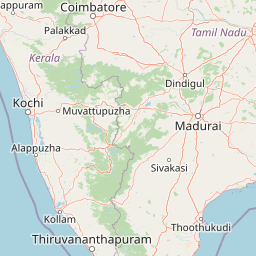
Understand where Eravikulam National Park sits in India through a broader geographic reading of the surrounding landscape, nearby location context, and its mapped position within the national park landscape.

How Eravikulam National Park fits into India

India is a South Asian country bordered by the Indian Ocean, Arabian Sea, and Bay of Bengal. It shares land borders with Pakistan, China, Nepal, Bhutan, Bangladesh, and Myanmar. The country has a population of over 1.4 billion people and operates as a federal parliamentary republic with its capital in New Delhi.

Wider geography shaping Eravikulam National Park in India

India occupies the Indian subcontinent in South Asia, bordered by the Arabian Sea to the southwest, the Bay of Bengal to the southeast, and the Indian Ocean to the south. It shares land borders with Pakistan to the west, China, Nepal, and Bhutan to the north, and Bangladesh and Myanmar to the east. The territory also includes the Andaman and Nicobar Islands in the Indian Ocean.

Map view of Eravikulam National Park

Use this park location map to pinpoint Eravikulam National Park in India, understand its exact geographic position, and read its mapped placement within the surrounding landscape more clearly.

Pigeon | © OpenStreetMap contributors

Location context for Eravikulam National Park

ErnakulamIdukkiKerala
Park atlas

Compare montane landscapes and conservation efforts of protected areas within the Western Ghats region surrounding Eravikulam National Park.

Discover Other National Parks and Protected Areas Near Eravikulam National Park
Continue your exploration from Eravikulam National Park by browsing other national parks and protected areas within the contiguous Western Ghats. This extended view allows you to compare diverse montane grassland ecosystems, shola forest patches, and endemic wildlife conservation efforts across a wider geographic spread.
National parkIdukki

Mathikettan Shola National Park: National Park Exploration and Geographic Mapping

Discover its protected landscape and regional context.

Mathikettan Shola National Park, a designated national park in the Idukki region, offers a focal point for understanding protected landscapes and their geographic distribution. This entry details the park's mapped boundaries and its specific setting within the regional geography, providing an atlas-level view of its conservation value. Users can explore the structured geographic identity of this protected natural area, enriching their understanding of India's park network.

Area
12.82 km²
Established
2003
IUCN
II
Relief
Mountain
National parkKerala

Periyar National Park: National Park Protected Area Atlas and Geographic Context

Mapped protected lands and regional landscape exploration in Kerala.

Discover Periyar National Park as a distinct protected landscape offering rich geographic context for atlas exploration. This entry details its mapped boundaries and its significance within the broader regional geography of Kerala. Understand the natural terrain and protected-area distribution that makes Periyar National Park a key element in India's conservation mapping.

Area
350.54 km²
Established
1982
IUCN
II
Visitors
754.3K annual
Watercolor illustration of green hills, a river, and distant pink mountains
National parkKerala

Silent Valley National Park: Kerala's Protected Landscape and Geographic Atlas

Explore mapped boundaries and regional terrain in South India.

Silent Valley National Park stands as a key protected area within Kerala, India, offering rich insights into its geographic setting. This destination provides an atlas-driven view of the park's mapped boundaries, its integration with the surrounding regional geography, and the character of its natural landscapes. Users can engage with detailed information designed for structured exploration of protected natural areas and their mapped contexts.

Area
89.52 km²
Established
1984
IUCN
II
Relief
Mountain
National parkNilgiri District

Mukurthi National Park: Nilgiri District's Protected Montane Grassland and Shola Ecosystem

Explore a vital refuge for the endangered Nilgiri tahr.

Mukurthi National Park, situated in the Nilgiri District of India, is an essential protected area celebrated for its distinctive montane landscape. This national park plays a critical role in the survival of the endangered Nilgiri tahr, protecting the rare shola-grassland ecosystem where they thrive. Its dramatic terrain, high elevations, and unique ecological associations make it a focal point for understanding conservation geography and the mapped boundaries of protected lands within the Western Ghats.

Area
78.46 km²
Established
1990
IUCN
II
Relief
Mountain
Watercolor painting showing green fields, pink and yellow areas, and distant mountains
National parkNilgiri District

Mudumalai National Park: National Park Identity and Geographic Context in Nilgiri District

Mapped protected area and natural terrain details for this key Indian park.

Delve into the specific geographic identity of Mudumalai National Park, a protected national park situated in the Nilgiri District. This detail page provides access to its mapped natural landscape, helping users understand its protected boundaries and regional geographic significance. It serves as a foundational point for exploring the park's unique terrain within India's atlas of natural protected areas.

Area
321 km²
Established
1940
IUCN
II
Relief
Mountain
National parkKarnataka

Bandipur National Park: Karnataka's Protected Landscape and National Park Atlas Entry

Discover mapped terrain and diverse forest ecosystems in South India.

Bandipur National Park, a prominent national park within Karnataka, serves as a vital hub for understanding protected area geography and landscape diversity. Its ecological significance is amplified by its location at the intersection of the Deccan Plateau and the Western Ghats, supporting a unique blend of forest types and rich biodiversity. This entry provides essential context for atlas-based discovery, detailing the park's mapped terrain, its role as a tiger reserve, and its contribution to the Nilgiri Biosphere Reserve's conservation landscape.

Area
1,456.3 km²
Established
1973
IUCN
II
Relief
Mixed relief
National parkKarnataka

Nagarahole National Park: National Park within Karnataka's Protected Geography

Explore mapped boundaries and regional landscape context.

Nagarahole National Park stands as a distinct national park entity within the state of Karnataka, India. This section focuses on its specific geographic footprint and the protected landscape it encompasses, offering valuable data for users engaged in atlas-based discovery of India's conservation areas and natural terrains. Understand its mapped geography and regional significance.

Area
847.98 km²
Established
1983
IUCN
II
Relief
Upland
National parkTamil Nadu

Gulf of Mannar Marine National Park: Protected Island Archipelago and Marine Atlas

Explore India's vital marine national park and its coral reef ecosystems.

Gulf of Mannar Marine National Park is a designated national park located in Tamil Nadu, India, protecting a chain of 21 islands and their surrounding marine environments. This protected area is renowned for its extensive coral reefs, crucial seagrass meadows supporting dugongs, and diverse fish species, making it a key site for marine conservation and geographic exploration. The park's unique island landscape and intertidal zones offer a distinct perspective on coastal protected areas within the Indian Ocean, providing rich material for atlas-style discovery and understanding regional marine geography.

Area
560 km²
Established
1986
IUCN
II
Relief
Lowland

Common questions about visiting, size, designation, and location context for Eravikulam National Park

Eravikulam National Park FAQs for park facts, access, geography, and protected area context
Find quick answers about Eravikulam National Park, including protected-area facts, park geography, trail and visitor context, and how the park fits into its surrounding country and regional landscape.
MoriAtlas Explorer

Continue Your Protected Areas Search Across the Global Atlas

Deepen your exploration by continuing the structured search for national parks and protected areas worldwide. Utilize the comprehensive filtering capabilities to compare different conservation landscapes and refine your understanding of global park geography. Discover more about the distribution and characteristics of protected natural areas.

Global natural geography