Mori Atlas logo
National parkMudumalai National Park

Explore the precise park boundaries and natural terrain within this significant Indian national park.

Mudumalai National Park: Protected Landscape Geography and Mapped Boundaries in Nilgiri District

(Mudumalai Tiger Reserve)

Mudumalai National Park represents a vital protected landscape located in the Nilgiri District of Tamil Nadu, India. This page offers users an atlas-driven understanding of the park's geographic scope, allowing for exploration of its mapped natural terrain and protected boundaries within the broader regional context of the Nilgiri Hills. Discover the specific landscape features that define this important national park.

tiger reserveelephant habitatWestern Ghatstropical forestbirdwatchingwildlife corridor
Illustration of a waterfall cascading over rocky cliffs with forested mountains and a setting sun

Mudumalai National Park

National park

Park overview

Structured park overview, official facts, and landscape profile for Mudumalai National Park

Mudumalai National Park park facts, protected area profile, and essential visitor context
Review the core facts for Mudumalai National Park, including designation, size, terrain, visitor scale, habitats, and operating context in one park-focused overview.

About Mudumalai National Park

Mudumalai National Park occupies a pivotal position in the Western Ghats, a UNESCO World Heritage Site recognized for its extraordinary biological diversity. The park's terrain consists of undulating hills with predominantly hornblendite and biotite gneiss bedrock, overlaid with black sandy loam in most areas and red heavy loam in the southern sector. This varied geology supports a complex mosaic of forest types that transition from moist deciduous in the lower elevations to semi-evergreen in the valleys and along watercourses. The park forms an essential corridor linking Bandipur National Park in Karnataka with Wayanad Wildlife Sanctuary in Kerala, enabling seasonal migration of elephants and other large mammals across state boundaries. The forest composition is dominated by teak and axlewood, with numerous other species including flame-of-the-forest, Indian laurel, kusum tree, Malabar kino, and Indian rosewood creating a structurally diverse canopy. The park's rivers and streams support riparian vegetation including mango and persimmon trees, while giant thorny bamboo forms dense stands in moist deciduous areas. This ecological richness makes Mudumalai a cornerstone of conservation in the Nilgiri Hills.

Quick facts and research context for Mudumalai National Park

Mudumalai National Park covers 321 square kilometers in the Nilgiri District of Tamil Nadu, India, at elevations ranging from 850 to 1,250 meters. The park forms part of the Nilgiri Biosphere Reserve, the first biosphere reserve established in India in 1986, and was designated as a Tiger Reserve in 2007 under Project Tiger. Annual rainfall averages approximately 1,420 millimeters, supporting tropical moist deciduous and semi-evergreen forest habitats. The park contains the Moyar River and five tributaries, with several artificial waterholes providing drinking water for wildlife during dry seasons. It shares boundaries with Bandipur National Park to the north, Wayanad Wildlife Sanctuary to the west, and Sigur Reserve Forest to the east.

Park context

Deeper park guide and search-rich context for Mudumalai National Park

Mudumalai National Park history, landscape, wildlife, and travel context
Explore Mudumalai National Park through its history, landscape character, ecosystems, wildlife, conservation priorities, cultural context, and seasonal travel timing in a structured park guide built for atlas discovery and search intent.

Why Mudumalai National Park stands out

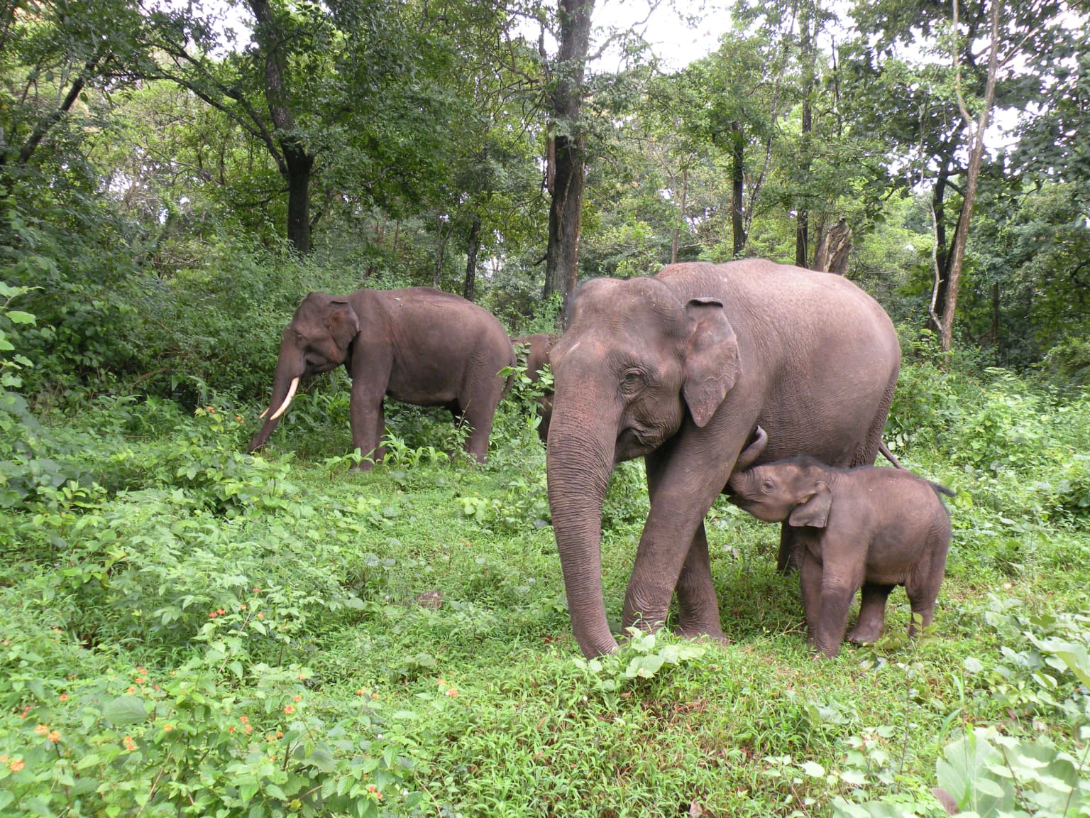
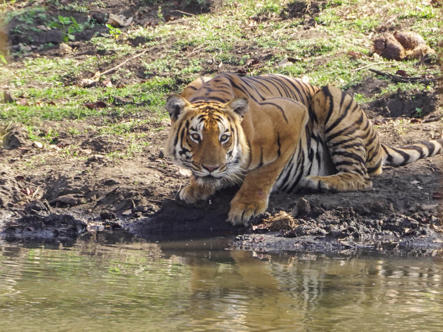
Mudumalai is renowned as one of the most significant tiger habitats in India, with an estimated population of around 103 tigers in the wider tiger reserve. The park also supports one of the largest Asian elephant populations in the Nilgiri Biosphere Reserve, with estimates ranging from 536 to 1,001 individuals in 25 herds. The park's location within a critical wildlife corridor provides the highest landscape connectivity for Asian elephants in the region. Its diverse habitats support multiple endangered species including the Indian leopard, gaur, sambar deer, and critically important vulture populations nesting in the Moyar River valley.

Brown and gray bird with yellow eye perched on tree branch against blue sky
Oriental Honey Buzzard perched on tree branch in Mudumalai National Park

Mudumalai National Park history and protected-area timeline

The name Mudumalai derives from Tamil, with 'mutu' meaning old or ancient, 'mudhukadu' meaning ancient forest, and 'malai' meaning hill or mountain. British colonial records show the forest was rented from the Raja of Neelambur in 1857 for commercial logging operations. In 1914, large tracts on the Sigur Plateau were declared reserve forests for systematic timber extraction. The formal protected status began in 1940 when approximately 60 square kilometers were established as Mudumalai Wildlife Sanctuary. The sanctuary was significantly enlarged in 1977, and its ecological significance was formally recognized when it became part of the Nilgiri Biosphere Reserve in 1986. The park achieved its highest protection status in April 2007 when it was declared a Tiger Reserve under Project Tiger, with formal notification as a Critical Tiger Habitat following in December 2007. At the time of tiger reserve designation, approximately 1,947 people lived in 28 hamlets within the reserve, with proposals for resettlement emerging in 2010. Funding has been provided through Project Tiger, with the Government of India and Government of Tamil Nadu jointly supporting conservation efforts.

Mudumalai National Park landscape and geographic character

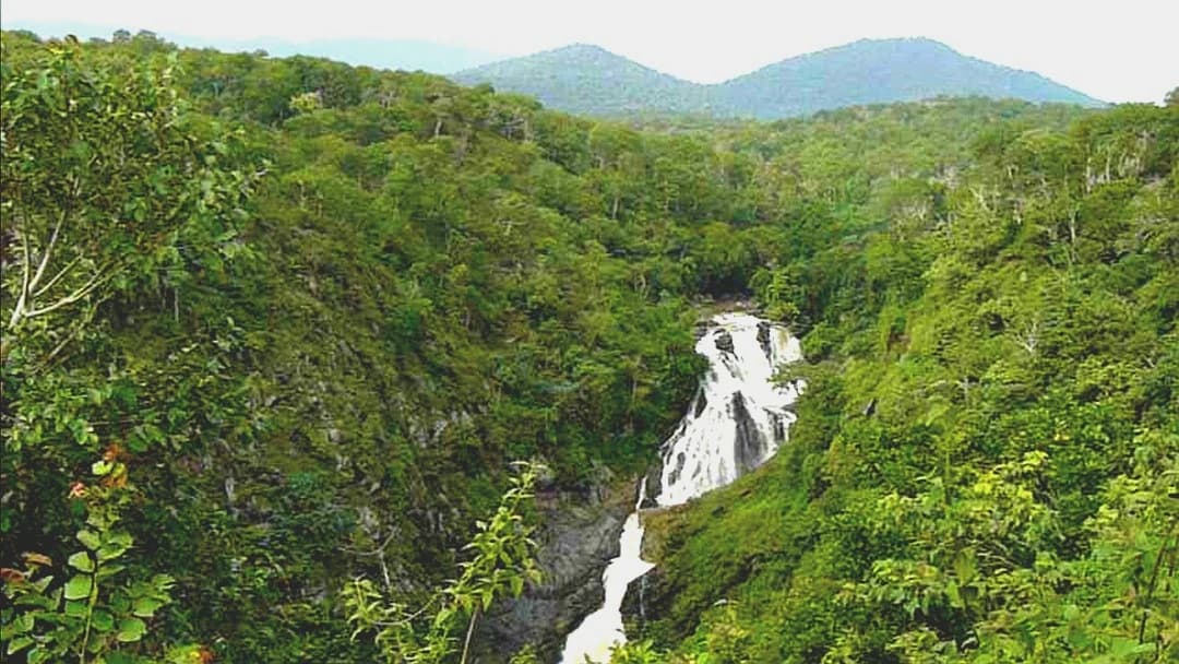
The landscape of Mudumalai National Park features a tapestry of rolling hills, deep valleys, and river corridors that create diverse microhabitats throughout the protected area. The terrain rises from around 850 meters in the lower reaches to approximately 1,250 meters in the higher elevations, with the western boundary marked by the confluence of the Moyar River entering from the adjacent Wayanad Wildlife Sanctuary. The river is joined by five major tributaries within the park boundaries, carving valleys that support unique riparian ecosystems distinct from the surrounding deciduous forest. Rocky outcrops and cliffs appear in certain areas, particularly along the steeper sections of the river courses where waterfalls create scenic focal points. The park contains extensive grasslands particularly in the vicinity of water sources, where gaur and other ungulates congregate during dry seasons. The eastern portions transition into drier forest types as precipitation decreases, creating an ecological gradient across the park's extent. Artificial waterholes have been constructed throughout the park to ensure reliable water access for wildlife during the dry months.

Three elephants, including a calf, standing in a lush green forest with dense vegetation.
Elephants, including a calf, in the forested terrain of Mudumalai National Park.

Mudumalai National Park ecosystems, habitats, and plant life

The forest ecosystem of Mudumalai represents the South Western Ghats moist deciduous forests ecoregion, supporting exceptional plant diversity with 498 documented species across multiple growth forms. Trees number 154 species including prominent species such as teak, axlewood, flame-of-the-forest, Indian laurel, and Malabar kino, with stem densities exceeding 105 trees per hectare in many areas. The shrub layer contains 77 species including ceylon satinwood, red cedar, and catechu, while the herb layer supports 214 species and climbers add another 53 vine species. The forest structure varies from dense closed-canopy stands in moisture-receiving valleys to more open deciduous woodland on exposed slopes. Moist deciduous forest predominates but interspersed patches of semi-evergreen vegetation occur in ravines and along watercourses where soil moisture remains higher throughout the year. The invasive species Lantana camara has spread in some areas, affecting native plant dispersal patterns, though it does not appear to uniformly suppress all native shrub regeneration.

Malabar Giant Squirrel perched on a tree branch with green leaves in the background
Malabar Giant Squirrel on a tree branch in forest

Mudumalai National Park wildlife and species highlights

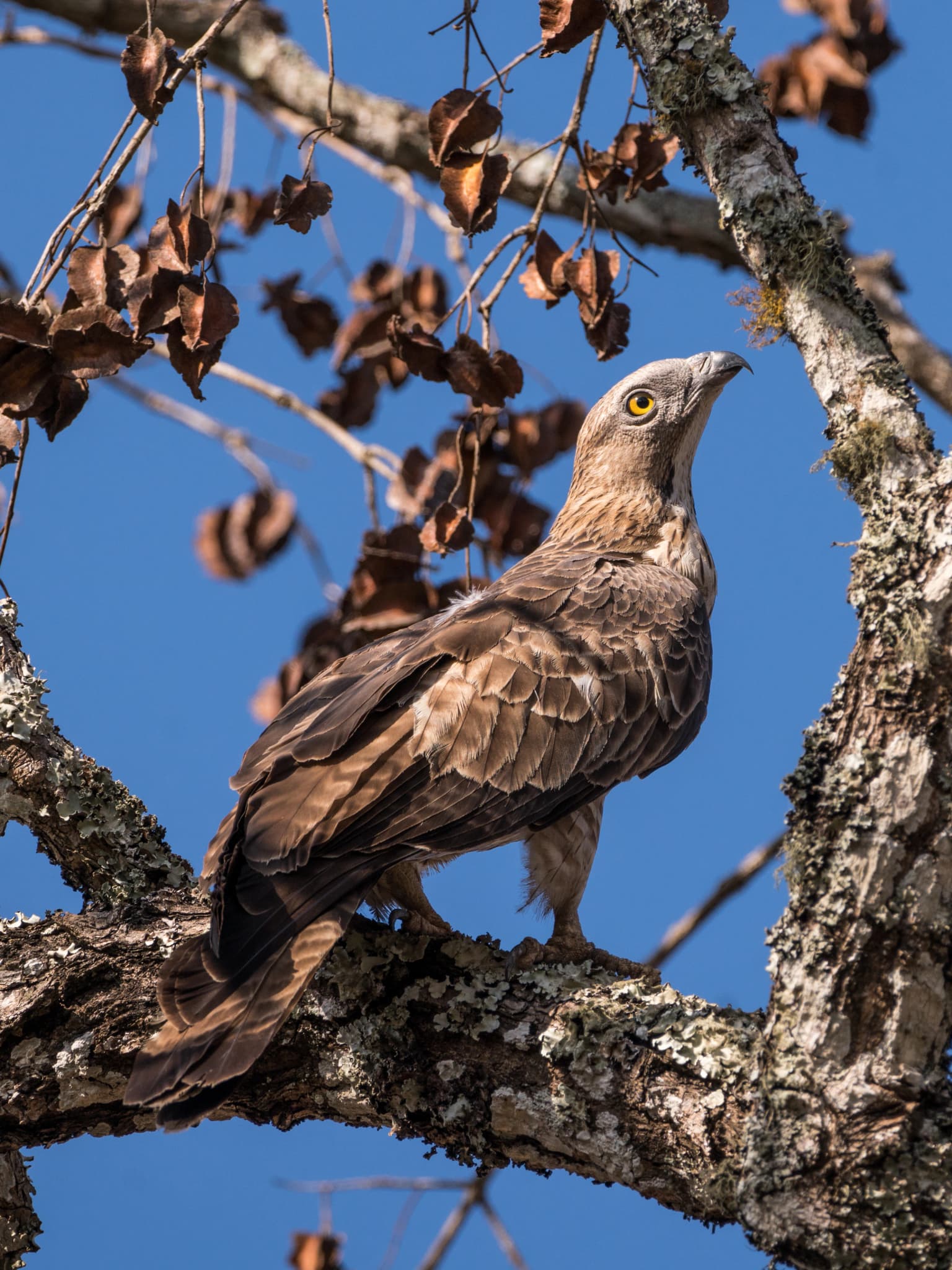
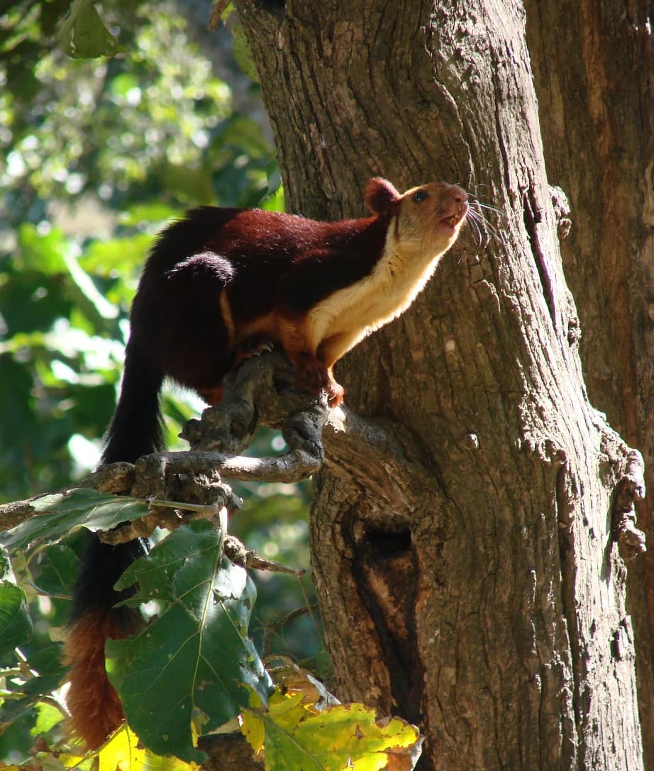
Mudumalai supports remarkable mammalian diversity with 18 carnivore and 10 herbivore species documented within its boundaries. The tiger population represents one of the most significant breeding populations in India, with approximately 19 tigers in the core 107 square kilometer area surveyed between 2008 and 2009, and an estimated 103 resident tigers in the wider tiger reserve as of 2018. Asian elephants represent the largest mammals present, with populations estimated between 536 and 1,001 individuals forming up to 25 herds. The gaur, India's largest wild cattle, forms herds of up to 42 individuals, while sambar deer and chital comprise the primary ungulate prey base. Leopard populations number approximately 29 individuals in the core area, with smaller cats including jungle cat, rusty-spotted cat, and leopard cat also present. Dholes form packs with home ranges exceeding 80 square kilometers, while other notable predators include sloth bear and multiple mongoose species. The bird fauna includes 266 species, with resident breeders including Malabar grey hornbill, Indian peafowl, and numerous raptors. Vulture colonies in the Moyar River valley support approximately 200 white-rumped vultures and 30 white-backed vulture nests. The reptile fauna includes Indian rock python, mugger crocodile, and various snake species, while the Moyar River system supports 38 fish species.

Waterfall with multiple tiers flowing through dense green forest with mountains in background
Moyar Falls cascading through lush green forest in Mudumalai National Park

Mudumalai National Park conservation status and protection priorities

Mudumalai's conservation significance stems from its critical role in the Nilgiri Biosphere Reserve, the first biosphere reserve established in India and one of the largest protected area networks in the country. The park forms part of an essential wildlife corridor that provides the highest landscape connectivity for Asian elephants in the region, enabling seasonal movement between protected areas in Tamil Nadu, Karnataka, and Kerala. As a designated Tiger Reserve, the park receives dedicated funding through Project Tiger for anti-poaching patrols, habitat management, and community engagement. The declaration of Critical Tiger Habitat status in 2007 provides enhanced legal protection for core tiger territories. However, the park faces significant conservation challenges including road mortality on three public roads that traverse the protected area, causing deaths of mammals, reptiles, and amphibians. Forest fires have affected the northern portions since 1999, with six major fires between 1999 and 2013 impacting areas up to 85 square kilometers. Poaching has claimed approximately 50 elephants between 1979 and 2011. Conservation priorities include mitigating roadkill mortality, managing fire regimes, and balancing tourism development with habitat protection.

Mudumalai National Park cultural meaning and human context

The region surrounding Mudumalai has historical connections to the Raja of Neelambur, from whom the British government rented forest land for logging in the mid-19th century. At the time of tiger reserve designation in 2007, approximately 1,947 people inhabited 28 hamlets within the reserve boundaries, maintaining traditional livelihoods including cattle husbandry. The Tamil place name itself reflects the cultural significance of the area as an ancient forest landscape. The park lies in proximity to communities in Gudalur, the nearest town, where local economies have historically depended on forest resources. Contemporary conservation efforts include engagement with these local communities regarding resettlement proposals that have generated debate among activists and conservationists concerning transparency and democratic process.

A tiger with orange and black stripes drinking from a body of water
Tiger drinking water at the edge of a pond in Mudumalai National Park

Top sights and standout views in Mudumalai National Park

Mudumalai offers exceptional wildlife viewing opportunities in one of India's most biologically diverse protected landscapes. The tiger reserve status reflects robust populations of Bengal tigers and Asian elephants that can be observed in their natural habitat. The Moyar River valley supports significant vulture colonies with nesting populations of white-rumped and white-backed vultures, a rare sight in modern India. The park's position as a critical corridor within the Nilgiri Biosphere Reserve makes it essential for maintaining genetic connectivity between elephant populations across three states. The varied topography and forest types support extraordinary bird diversity with over 266 species, making it a prime destination for birdwatching. The historical evolution from colonial logging area to modern tiger reserve demonstrates changing approaches to wilderness conservation in India.

A multi-tiered waterfall cascading down rocky formations with flowing water
Waterfalls in Mudumalai National Park

Best time to visit Mudumalai National Park

The optimal visiting period for Mudumalai National Park coincides with the dry season from November to May, when water sources become limited and wildlife congregates around rivers and artificial waterholes, enhancing sighting opportunities. The summer months of April and May typically offer the best chances to observe tigers and elephants as they visit water bodies, though temperatures can be high. The monsoon season from June to September brings heavy rainfall exceeding 1,400 millimeters annually, which can restrict access and make wildlife observation more challenging. The winter months from December to February provide comfortable temperatures and remain popular for wildlife viewing, though animals may be more dispersed across the landscape. The park remains open throughout the year though some areas may have restricted access during the monsoon.

Park location guide

Geography guide, regional context, and park location map for Mudumalai National Park

Mudumalai National Park park geography, regions, and map view in India
Understand where Mudumalai National Park sits in India through a broader geographic reading of the surrounding landscape, nearby location context, and its mapped position within the national park landscape.

How Mudumalai National Park fits into India

India is a South Asian country bordered by the Indian Ocean, Arabian Sea, and Bay of Bengal. It shares land borders with Pakistan, China, Nepal, Bhutan, Bangladesh, and Myanmar. The country has a population of over 1.4 billion people and operates as a federal parliamentary republic with its capital in New Delhi.

Wider geography shaping Mudumalai National Park in India

India occupies the Indian subcontinent in South Asia, bordered by the Arabian Sea to the southwest, the Bay of Bengal to the southeast, and the Indian Ocean to the south. It shares land borders with Pakistan to the west, China, Nepal, and Bhutan to the north, and Bangladesh and Myanmar to the east. The territory also includes the Andaman and Nicobar Islands in the Indian Ocean.

Map view of Mudumalai National Park

Use this park location map to pinpoint Mudumalai National Park in India, understand its exact geographic position, and read its mapped placement within the surrounding landscape more clearly.

Pigeon | © OpenStreetMap contributors

Location context for Mudumalai National Park

Nilgiri DistrictTamil Nadu

Examine the diverse landscapes, forest habitats, and riverine environments that shape Mudumalai's unique protected-area character.

Mudumalai National Park Photos: Visualizing Diverse Landscapes, Terrain, and Protected-Area Character
Browse imagery of Mudumalai National Park, revealing its distinctive rolling hills, deep river valleys, and diverse tropical forest ecosystems across the Western Ghats foothills. These visuals provide crucial context for understanding the park's ecological gradients, key wildlife habitats, and the unique conservation landscape of this vital tiger reserve.

Brown and gray bird with yellow eye perched on tree branch against blue sky

A river reflecting trees and sky at sunset with sun rays visible through clouds

Three elephants, including a calf, standing in a lush green forest with dense vegetation.

Malabar Giant Squirrel perched on a tree branch with green leaves in the background

Waterfall with multiple tiers flowing through dense green forest with mountains in background

Leopard with spotted coat climbing a tree trunk in a forested area

A tiger with orange and black stripes drinking from a body of water

A multi-tiered waterfall cascading down rocky formations with flowing water

Indian pond heron standing in shallow water with muddy bank and vegetation in background

White tiger with black stripes lying down, showing facial features and body pattern

Large snake with black and yellow patterned scales constricting and swallowing a brown animal with white spots among dry branches and foliage

Dark blue sky with scattered clouds, sunlight breaking through, silhouetted mountain peaks, and foreground vegetation

Grassy area in foreground with dense forest of tall trees and vegetation in background

Park atlas

Explore the regional protected landscapes surrounding Mudumalai, mapping adjacent national parks and wildlife sanctuaries across the Nilgiri Biosphere.

Discover Nearby Protected Areas and National Parks Around Mudumalai National Park in the Western Ghats
Continue your discovery of India's protected areas by exploring national parks and wildlife sanctuaries near Mudumalai National Park in the Nilgiri Mountains. Compare the diverse conservation landscapes, trace geographic connections within the Western Ghats, and understand the vital regional context of these interconnected protected areas.
National parkKarnataka

Bandipur National Park: Karnataka's Protected Landscape and National Park Atlas Entry

Discover mapped terrain and diverse forest ecosystems in South India.

Bandipur National Park, a prominent national park within Karnataka, serves as a vital hub for understanding protected area geography and landscape diversity. Its ecological significance is amplified by its location at the intersection of the Deccan Plateau and the Western Ghats, supporting a unique blend of forest types and rich biodiversity. This entry provides essential context for atlas-based discovery, detailing the park's mapped terrain, its role as a tiger reserve, and its contribution to the Nilgiri Biosphere Reserve's conservation landscape.

Area
1,456.3 km²
Established
1973
IUCN
II
Relief
Mixed relief
National parkNilgiri District

Mukurthi National Park: Nilgiri District's Protected Montane Grassland and Shola Ecosystem

Explore a vital refuge for the endangered Nilgiri tahr.

Mukurthi National Park, situated in the Nilgiri District of India, is an essential protected area celebrated for its distinctive montane landscape. This national park plays a critical role in the survival of the endangered Nilgiri tahr, protecting the rare shola-grassland ecosystem where they thrive. Its dramatic terrain, high elevations, and unique ecological associations make it a focal point for understanding conservation geography and the mapped boundaries of protected lands within the Western Ghats.

Area
78.46 km²
Established
1990
IUCN
II
Relief
Mountain
Watercolor illustration of green hills, a river, and distant pink mountains
National parkKerala

Silent Valley National Park: Kerala's Protected Landscape and Geographic Atlas

Explore mapped boundaries and regional terrain in South India.

Silent Valley National Park stands as a key protected area within Kerala, India, offering rich insights into its geographic setting. This destination provides an atlas-driven view of the park's mapped boundaries, its integration with the surrounding regional geography, and the character of its natural landscapes. Users can engage with detailed information designed for structured exploration of protected natural areas and their mapped contexts.

Area
89.52 km²
Established
1984
IUCN
II
Relief
Mountain
National parkKarnataka

Nagarahole National Park: National Park within Karnataka's Protected Geography

Explore mapped boundaries and regional landscape context.

Nagarahole National Park stands as a distinct national park entity within the state of Karnataka, India. This section focuses on its specific geographic footprint and the protected landscape it encompasses, offering valuable data for users engaged in atlas-based discovery of India's conservation areas and natural terrains. Understand its mapped geography and regional significance.

Area
847.98 km²
Established
1983
IUCN
II
Relief
Upland
National parkKerala

Eravikulam National Park: National Park with Mapped Protected Boundaries in Kerala

Understanding its geographic setting and landscape identity.

Delve into the protected landscape of Eravikulam National Park, a significant national park located in Kerala. This detailed entry focuses on its geographic coordinates, mapped boundaries, and its role as a distinct protected area within the regional geography. It serves as a valuable resource for exploring the park's natural terrain and its importance in conservation landscapes.

Area
97 km²
Established
1978
IUCN
II
Visitors
148.4K annual
Watercolor illustration showing mountains, a winding river, and green vegetation
National parkKarnataka

Bannerghatta National Park: A National Park in Karnataka with Mapped Geographic Identity

Explore the protected landscape and regional terrain context.

Bannerghatta National Park is an important protected area within the state of Karnataka, India. Its designation as a national park signifies its role in preserving regional natural landscapes and providing valuable geographic context for atlas exploration. Users can examine its mapped boundaries and understand its placement within the diverse terrain characteristic of South India and the Western Ghats, contributing to a structured understanding of protected lands.

Area
260.51 km²
Established
1974
IUCN
II
Relief
Mountain
National parkIdukki

Mathikettan Shola National Park: National Park Exploration and Geographic Mapping

Discover its protected landscape and regional context.

Mathikettan Shola National Park, a designated national park in the Idukki region, offers a focal point for understanding protected landscapes and their geographic distribution. This entry details the park's mapped boundaries and its specific setting within the regional geography, providing an atlas-level view of its conservation value. Users can explore the structured geographic identity of this protected natural area, enriching their understanding of India's park network.

Area
12.82 km²
Established
2003
IUCN
II
Relief
Mountain
Watercolor painting showing a landscape with rolling hills, forests, and distant mountains
National parkKarnataka

Kudremukh National Park: Karnataka's Protected Landscape and River Origin

Explore the geography of shola forests and grasslands.

Kudremukh National Park is a pivotal protected landscape in Karnataka, India, recognized for its distinctive montane grasslands and shola forests. This national park is a critical source for three major rivers: the Tunga, Bhadra, and Nethravathi, highlighting its ecological and geographic significance within the Western Ghats. The park's terrain features rolling hills and steep western slopes, contributing to its unique biodiversity and landscape character for atlas-based discovery.

Area
600.57 km²
Established
1987
IUCN
II
Relief
Mountain

Common questions about visiting, size, designation, and location context for Mudumalai National Park

Mudumalai National Park FAQs for park facts, access, geography, and protected area context
Find quick answers about Mudumalai National Park, including protected-area facts, park geography, trail and visitor context, and how the park fits into its surrounding country and regional landscape.
MoriAtlas Explorer

Continue Your Protected Areas Search Across the Global Atlas

Deepen your exploration by continuing the structured search for national parks and protected areas worldwide. Utilize the comprehensive filtering capabilities to compare different conservation landscapes and refine your understanding of global park geography. Discover more about the distribution and characteristics of protected natural areas.

Global natural geography