Mori Atlas logo
National parkSilent Valley National Park

Discover the mapped boundaries and regional terrain of this Indian National Park.

Silent Valley National Park: Protected Landscape and Geographic Context in Kerala

Silent Valley National Park represents a significant protected landscape within the state of Kerala, India. This canonical entry provides a detailed atlas-style exploration, focusing on the park's geographic identity and its place within the broader regional context of South India. Understand the mapped extent of this protected area and its natural terrain.

national parkWestern Ghatsrainforestendangered speciesbiosphere reserveprimate habitat
Stylized illustration of a waterfall cascading between rocky cliffs with pine trees and mountains in the background under a partly cloudy sky

Silent Valley National Park

National park

Park overview

Structured park overview, official facts, and landscape profile for Silent Valley National Park

Silent Valley National Park park facts, protected area profile, and essential visitor context
Review the core facts for Silent Valley National Park, including designation, size, terrain, visitor scale, habitats, and operating context in one park-focused overview.

About Silent Valley National Park

Silent Valley National Park represents a cornerstone of biodiversity conservation in the Western Ghats, a mountain range recognised by UNESCO as a World Heritage Site in 2007. The park occupies a rectangular tract of approximately 89.52 square kilometres in the Nilgiri Hills, bordered by the Attappady Reserved Forest to the north and separated from the high-altitude plateaus of the Nilgiris by continuous ridges including Sispara Peak at 2,206 metres. The landscape is dominated by tropical moist evergreen forest in the valley floors and transitions to South Western Ghats montane rain forests at elevations above 1,000 metres. Above 1,500 metres, the canopy gives way to stunted shola forests interspersed with open grasslands that have never been disturbed by human settlement. The Kunthipuzha River bisects the park from north to south, characterised by its crystal-clear, pesticide-free waters. The park's complete enclosure within a ring of hills creates a distinct micro-climate, with the valley receiving substantial rainfall from both the southwest and northeast monsoons, supplemented by significant moisture from mist condensation. This hydrological isolation has allowed the ecosystem to develop exceptional levels of endemism across flora and fauna.

Quick facts and research context for Silent Valley National Park

Silent Valley National Park lies in the trijunction of Palakkad district in Kerala and Nilgiris district in Tamil Nadu, with portions extending into Malappuram district. The park's elevation ranges from 658 metres to 2,328 metres at Anginda Peak, with most of the protected area falling between 880 and 1,200 metres. The Kunthipuzha River flows through the entire 15-kilometre length of the park, draining into the Bharathapuzha River. The park experiences heavy monsoon rainfall exceeding 6,000 millimetres annually and maintains consistently high humidity. It forms a contiguous protected landscape with Karimpuzha National Park to the north and Mukurthi National Park to the northeast, all within the Nilgiri Sub-Cluster of the Western Ghats World Heritage Site.

Park context

Deeper park guide and search-rich context for Silent Valley National Park

Silent Valley National Park history, landscape, wildlife, and travel context
Explore Silent Valley National Park through its history, landscape character, ecosystems, wildlife, conservation priorities, cultural context, and seasonal travel timing in a structured park guide built for atlas discovery and search intent.

Why Silent Valley National Park stands out

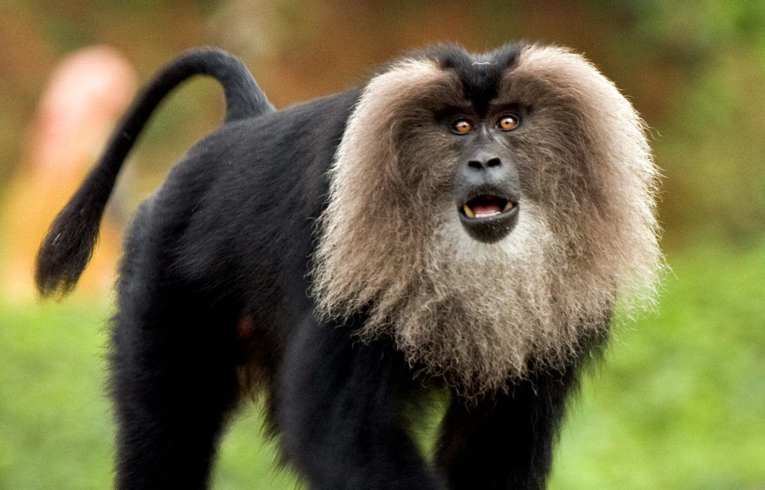
Silent Valley is renowned as the stronghold of the endangered lion-tailed macaque, one of India's most threatened primates. The park protects one of the most viable and undisturbed habitats remaining for this species, which depends on the flowering of Cullenia exarillata trees in the forest canopy. It is also notable for its exceptional plant diversity, including approximately 1,000 species of flowering plants with 108 orchid species, numerous endemic ferns, and economically valuable species such as cardamom and black pepper. The park's significance as a genetic resource for rice cultivation is historically important, as wild varieties from Silent Valley contributed to disease-resistant hybrid rice varieties that supported the Green Revolution in Asia.

Green frog with yellow underbelly clinging to a branch against dark background
Green frog with yellow underbelly perched on a branch in Silent Valley National Park

Silent Valley National Park history and protected-area timeline

The history of Silent Valley National Park is profoundly shaped by the environmental movement that prevented its destruction. The first scientific exploration of the area occurred in 1847 by the botanist Robert Wight, and the British administration later declared the forest a reserve forest in 1914. Between 1927 and 1976, portions of the forest were subjected to forestry operations, but the valley itself remained largely undisturbed. In 1928, the site at Sairandhri on the Kunthipuzha River was identified as suitable for hydroelectric development, and by 1958 a 120-megawatt hydroelectric project costing Rs. 17 crore was proposed by the Kerala State Electricity Board. The valley became the focus of India's fiercest environmental movement of the 1970s when details of the Silent Valley Hydro-Electric Project emerged, revealing that the proposed reservoir would flood 8.3 square kilometres of virgin rainforest and threaten the lion-tailed macaque habitat. Scientists and activists including Romulus Whitaker mobilised public opposition, leading to the project's cancellation. The national park was officially established in 1980 and formally inaugurated on 7 September 1985, with a memorial at Sairandhri unveiled by Rajiv Gandhi. On 1 September 1986, it was designated as the core area of the Nilgiri Biosphere Reserve.

Silent Valley National Park landscape and geographic character

The physical landscape of Silent Valley National Park is defined by its position in the Nilgiri Hills at the southern extreme of the Western Ghats. The park forms a roughly rectangular basin measuring twelve kilometres from north to south and seven kilometres from east to west, cradled between continuous ridgelines that separate it from the higher plateaus to the north and east. The terrain slopes gradually southward toward the Palakkad plains while irregular ridges bound the western boundary. Elevation within the park ranges from 658 metres in the lower reaches to 2,328 metres at Anginda Peak, though most of the parkland lies between 880 and 1,200 metres. The underlying geology consists of granite with schists and gneiss, giving rise to loamy laterite soils on slopes and blackish, slightly acidic soils in the evergreen forests where organic matter accumulates. The Kunthipuzha River is the primary drainage, running the full north-south length of the park over a 12-kilometre course that drops from 1,861 metres to 900 metres in elevation, with the final eight kilometres being particularly gentle with a fall of only 60 metres.

Lion-tailed macaque with black fur and light brown beard standing in a green forest environment
Lion-tailed macaque in its natural habitat

Silent Valley National Park ecosystems, habitats, and plant life

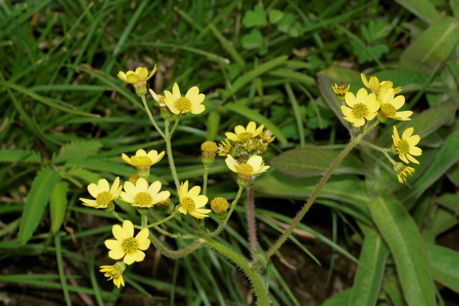
The ecological character of Silent Valley is defined by two principal forest types within the tropical and subtropical moist broadleaf forests ecoregion. The valley floors and lower slopes support tropical moist evergreen forest characterised by dense canopy species including Cullenia exarillata, Palaquium ellipticum, and Mesua ferrea, forming distinct tree associations that have been classified into six types across the park. At elevations above 1,000 metres, the vegetation transitions to South Western Ghats montane rain forest, and above 1,500 metres the evergreen canopy breaks into the characteristic shola forest formation, a mosaic of stunted trees interspersed with rolling grasslands that ecologists consider among the most biodiverse yet never-disturbed habitats on Earth. The park contains approximately 1,000 species of flowering plants, 108 orchid species including rare endemics like Ipsea malabarica and Bulbophyllum silentvalliensis, 100 ferns and fern allies, 200 liverworts, 75 lichens, and about 200 algae. The flora includes many economically valuable species such as cardamom, black pepper, and over 110 plant species used in Ayurvedic medicine, as well as a pest-resistant rice variety.

A black-furred Nilgiri langur with a light face sitting on a tree branch surrounded by green leaves
Nilgiri langur perched on a tree branch in dense foliage

Silent Valley National Park wildlife and species highlights

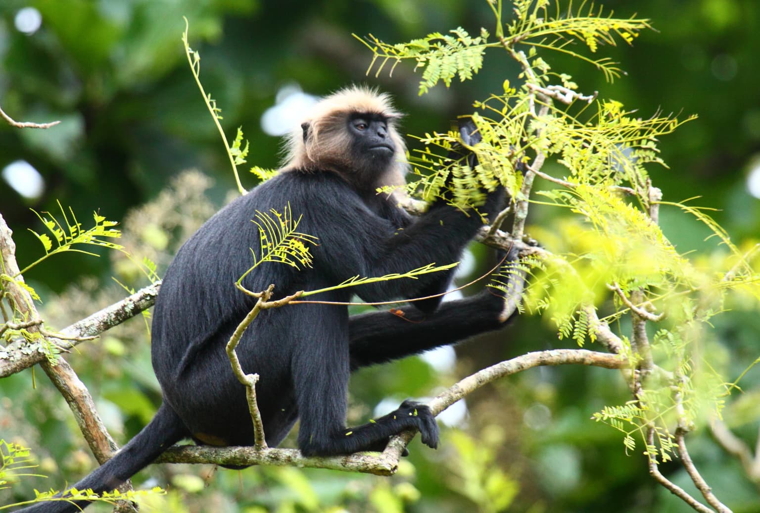
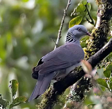
Silent Valley supports remarkable faunal diversity across multiple taxonomic groups. The park is most famous for its population of lion-tailed macaques, the largest remaining population of this endangered primate, which are confined primarily to the southern sector of the park and depend on the seasonal flowering of Cullenia exarillata trees. Fourteen troops of lion-tailed macaque and eighty-five troops of Nilgiri langur have been recorded, alongside occasional visits by bonnet macaques and Hanuman langurs. The mammal fauna includes at least 34 species including the Nilgiri tahr, Malabar giant squirrel, and several bat species. Bird diversity is exceptional, with 138 species documented including 16 listed by BirdLife International as threatened or restricted range species such as the Nilgiri wood-pigeon, Malabar grey hornbill, and Nilgiri flycatcher. The park supports over 730 identified insect species, including 128 butterfly species and 400 moth species, with numerous endemic odonates bringing the total documented dragonfly and damselfly species to 109.

A Nilgiri Woodpigeon with gray plumage and striped neck pattern perched on a tree branch with green foliage
Nilgiri Woodpigeon perched on a moss-covered tree branch in a forested area

Silent Valley National Park conservation status and protection priorities

Silent Valley National Park holds exceptional conservation significance as the core area of the Nilgiri Biosphere Reserve within the Western Ghats World Heritage Site. The park represents one of the last viable habitats for the endangered lion-tailed macaque and Nilgiri langur, both endemic to the Western Ghats. Its protection preserves significant genetic resources, including wild rice varieties used in developing disease-resistant hybrid strains that underpinned the Asian Green Revolution. The park's biodiversity value has been recognised through its inclusion in the Nilgiri Sub-Cluster covering over 6,000 square kilometres. Conservation challenges include forest fire during dry seasons, illegal cannabis cultivation in the buffer zones, and encroachment pressures. The buffer zone of 147.22 square kilometres was approved in 2007 to provide additional protection, incorporating forests from Attappady, Mannarkkad, and Kalikavu ranges into a new Bhavani Forest Range. Ongoing research continues to discover new species, particularly insects and amphibians, underscoring the park's importance as a living laboratory of biodiversity.

Silent Valley National Park cultural meaning and human context

While Silent Valley itself shows no evidence of historical human settlement, the surrounding areas are home to indigenous tribal communities including the Mudugar, Irula, and Kurumbar peoples who inhabit the adjacent Attappady Reserved Forest. These communities have traditionally practiced agriculture and forest collection, with some engaged in the cultivation of a seedless cannabis variety known locally as Sairandhri, renowned for its quality. Many tribal members now work as day labourers and porters, with several communities facing economic hardship that has made them vulnerable to involvement in illegal activities. The visitors' centre at Sairandhri serves as the gateway to the park and includes a memorial commemorating the conservation movement that led to the park's establishment.

A white tiger with black stripes lying on the ground facing the camera
Close-up of a white tiger

Top sights and standout views in Silent Valley National Park

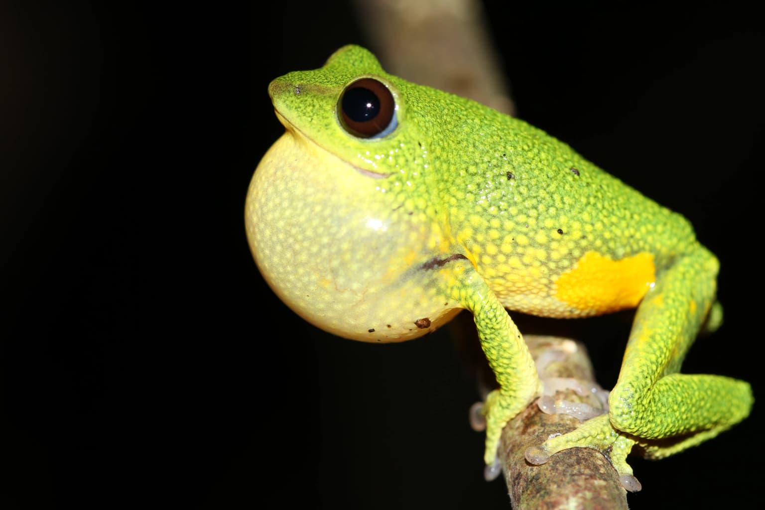
The Save Silent Valley movement of the 1970s stands as one of India's most significant environmental campaigns, ultimately resulting in the cancellation of a hydroelectric project that would have flooded eight square kilometres of virgin rainforest. The park contains the fifth-highest peak in South India, Mukurthi, and Anginda Peak within its vicinity. The Kunthipuzha River is one of the less torrential rivers of the Western Ghats, with a pesticide-free catchment. The park's Odonata diversity has been extensively studied, with 109 species documented through surveys conducted between 2018 and 2025. The Silent Valley Bush Frog, Raorchestes silentvalley, was first described from the park in 2016, named after this protected area.

Yellow flowers on a plant with green leaves and grass in background
Yellow flowering plant in Silent Valley National Park

Best time to visit Silent Valley National Park

Silent Valley can be visited throughout the year, though the ideal period is from October to March when the monsoon rainfall decreases and trails are more accessible. The southwest monsoon from June to September brings the heaviest precipitation, with the park receiving over 80% of its annual rainfall during this period, creating dramatic landscapes but potentially restricting access to some areas. The post-monsoon months offer lush green scenery, excellent visibility, and opportunities to observe wildlife as animals become more active in the cooler, drier conditions. The mean annual temperature is approximately 20.2°C, with April and May being the warmest months at around 23°C and January and February the coolest at 18°C. High humidity above 95% persists from June through December, creating a perpetually misty atmosphere throughout the forest.

Park location guide

Geography guide, regional context, and park location map for Silent Valley National Park

Silent Valley National Park park geography, regions, and map view in India
Understand where Silent Valley National Park sits in India through a broader geographic reading of the surrounding landscape, nearby location context, and its mapped position within the national park landscape.

How Silent Valley National Park fits into India

India is a South Asian country bordered by the Indian Ocean, Arabian Sea, and Bay of Bengal. It shares land borders with Pakistan, China, Nepal, Bhutan, Bangladesh, and Myanmar. The country has a population of over 1.4 billion people and operates as a federal parliamentary republic with its capital in New Delhi.

Wider geography shaping Silent Valley National Park in India

India occupies the Indian subcontinent in South Asia, bordered by the Arabian Sea to the southwest, the Bay of Bengal to the southeast, and the Indian Ocean to the south. It shares land borders with Pakistan to the west, China, Nepal, and Bhutan to the north, and Bangladesh and Myanmar to the east. The territory also includes the Andaman and Nicobar Islands in the Indian Ocean.

Map view of Silent Valley National Park

Use this park location map to pinpoint Silent Valley National Park in India, understand its exact geographic position, and read its mapped placement within the surrounding landscape more clearly.

Pigeon | © OpenStreetMap contributors

Location context for Silent Valley National Park

Kerala

Visualizing India's Undisturbed Montane Forests, Habitats, and Scenic Terrain in Kerala

Silent Valley National Park Photos: Explore Pristine Western Ghats Rainforest Landscapes
Browse a detailed visual atlas of Silent Valley National Park, showcasing its pristine South Western Ghats mountain rainforests, diverse habitats, and unique montane forest ecosystems. This curated imagery provides an essential perspective on the park's terrain, river systems, and the overall character of this vital protected area in Kerala.

Green frog with yellow underbelly clinging to a branch against dark background

A damselfly with transparent wings and a slender body resting on a green leaf

Lion-tailed macaque with black fur and light brown beard standing in a green forest environment

A black-furred Nilgiri langur with a light face sitting on a tree branch surrounded by green leaves

A Nilgiri Woodpigeon with gray plumage and striped neck pattern perched on a tree branch with green foliage

Wide view of mountainous landscape with valleys, green slopes, and distant peaks under a partly cloudy sky

A white tiger with black stripes lying on the ground facing the camera

Yellow flowers on a plant with green leaves and grass in background

A suspension bridge spanning a river with rocky banks and dense green forest in the background

Park atlas

Compare the diverse protected areas across the Nilgiri Hills and surrounding Western Ghats region of South India.

Discover Nearby National Parks and Protected Landscapes Surrounding Silent Valley National Park
Continue your exploration from Silent Valley National Park by discovering other national parks and protected areas across the Nilgiri Hills, a vital part of the Western Ghats montane rain forests. This comparison helps trace the regional spread of India's significant conservation landscapes, revealing interconnected ecosystems and diverse protected habitats.
National parkNilgiri District

Mukurthi National Park: Nilgiri District's Protected Montane Grassland and Shola Ecosystem

Explore a vital refuge for the endangered Nilgiri tahr.

Mukurthi National Park, situated in the Nilgiri District of India, is an essential protected area celebrated for its distinctive montane landscape. This national park plays a critical role in the survival of the endangered Nilgiri tahr, protecting the rare shola-grassland ecosystem where they thrive. Its dramatic terrain, high elevations, and unique ecological associations make it a focal point for understanding conservation geography and the mapped boundaries of protected lands within the Western Ghats.

Area
78.46 km²
Established
1990
IUCN
II
Relief
Mountain
Watercolor painting showing green fields, pink and yellow areas, and distant mountains
National parkNilgiri District

Mudumalai National Park: National Park Identity and Geographic Context in Nilgiri District

Mapped protected area and natural terrain details for this key Indian park.

Delve into the specific geographic identity of Mudumalai National Park, a protected national park situated in the Nilgiri District. This detail page provides access to its mapped natural landscape, helping users understand its protected boundaries and regional geographic significance. It serves as a foundational point for exploring the park's unique terrain within India's atlas of natural protected areas.

Area
321 km²
Established
1940
IUCN
II
Relief
Mountain
National parkKarnataka

Bandipur National Park: Karnataka's Protected Landscape and National Park Atlas Entry

Discover mapped terrain and diverse forest ecosystems in South India.

Bandipur National Park, a prominent national park within Karnataka, serves as a vital hub for understanding protected area geography and landscape diversity. Its ecological significance is amplified by its location at the intersection of the Deccan Plateau and the Western Ghats, supporting a unique blend of forest types and rich biodiversity. This entry provides essential context for atlas-based discovery, detailing the park's mapped terrain, its role as a tiger reserve, and its contribution to the Nilgiri Biosphere Reserve's conservation landscape.

Area
1,456.3 km²
Established
1973
IUCN
II
Relief
Mixed relief
National parkKarnataka

Nagarahole National Park: National Park within Karnataka's Protected Geography

Explore mapped boundaries and regional landscape context.

Nagarahole National Park stands as a distinct national park entity within the state of Karnataka, India. This section focuses on its specific geographic footprint and the protected landscape it encompasses, offering valuable data for users engaged in atlas-based discovery of India's conservation areas and natural terrains. Understand its mapped geography and regional significance.

Area
847.98 km²
Established
1983
IUCN
II
Relief
Upland
National parkKerala

Eravikulam National Park: National Park with Mapped Protected Boundaries in Kerala

Understanding its geographic setting and landscape identity.

Delve into the protected landscape of Eravikulam National Park, a significant national park located in Kerala. This detailed entry focuses on its geographic coordinates, mapped boundaries, and its role as a distinct protected area within the regional geography. It serves as a valuable resource for exploring the park's natural terrain and its importance in conservation landscapes.

Area
97 km²
Established
1978
IUCN
II
Visitors
148.4K annual
National parkIdukki

Mathikettan Shola National Park: National Park Exploration and Geographic Mapping

Discover its protected landscape and regional context.

Mathikettan Shola National Park, a designated national park in the Idukki region, offers a focal point for understanding protected landscapes and their geographic distribution. This entry details the park's mapped boundaries and its specific setting within the regional geography, providing an atlas-level view of its conservation value. Users can explore the structured geographic identity of this protected natural area, enriching their understanding of India's park network.

Area
12.82 km²
Established
2003
IUCN
II
Relief
Mountain
National parkKerala

Periyar National Park: National Park Protected Area Atlas and Geographic Context

Mapped protected lands and regional landscape exploration in Kerala.

Discover Periyar National Park as a distinct protected landscape offering rich geographic context for atlas exploration. This entry details its mapped boundaries and its significance within the broader regional geography of Kerala. Understand the natural terrain and protected-area distribution that makes Periyar National Park a key element in India's conservation mapping.

Area
350.54 km²
Established
1982
IUCN
II
Visitors
754.3K annual
Watercolor illustration showing mountains, a winding river, and green vegetation
National parkKarnataka

Bannerghatta National Park: A National Park in Karnataka with Mapped Geographic Identity

Explore the protected landscape and regional terrain context.

Bannerghatta National Park is an important protected area within the state of Karnataka, India. Its designation as a national park signifies its role in preserving regional natural landscapes and providing valuable geographic context for atlas exploration. Users can examine its mapped boundaries and understand its placement within the diverse terrain characteristic of South India and the Western Ghats, contributing to a structured understanding of protected lands.

Area
260.51 km²
Established
1974
IUCN
II
Relief
Mountain

Common questions about visiting, size, designation, and location context for Silent Valley National Park

Silent Valley National Park FAQs for park facts, access, geography, and protected area context
Find quick answers about Silent Valley National Park, including protected-area facts, park geography, trail and visitor context, and how the park fits into its surrounding country and regional landscape.
MoriAtlas Explorer

Continue Your Protected Areas Search Across the Global Atlas

Deepen your exploration by continuing the structured search for national parks and protected areas worldwide. Utilize the comprehensive filtering capabilities to compare different conservation landscapes and refine your understanding of global park geography. Discover more about the distribution and characteristics of protected natural areas.

Global natural geography