Mori Atlas logo
National parkPampadum Shola National Park

Discover the mapped geographic boundaries and natural terrain of this Indian national park.

Pampadum Shola National Park: India's Protected Landscape and National Park Atlas

Pampadum Shola National Park represents a significant protected landscape within India, offering critical geographic context for atlas exploration. As a designated national park, its mapped boundaries and regional terrain contribute to understanding India's protected areas. This entry focuses on the park's identity as a defined natural space, providing foundational information for geographic discovery and landscape analysis within the broader South Asian context.

Western GhatsShola ForestMontane ForestBiodiversity HotspotEndemic SpeciesKerala

Pampadum Shola National Park

National park

Park overview

Structured park overview, official facts, and landscape profile for Pampadum Shola National Park

Pampadum Shola National Park park facts, protected area profile, and essential visitor context

Review the core facts for Pampadum Shola National Park, including designation, size, terrain, visitor scale, habitats, and operating context in one park-focused overview.

About Pampadum Shola National Park

Pampadum Shola National Park occupies a modest area within the montane landscapes of Kerala's interior highlands. The Western Ghats, where the park is situated, constitute one of the world's eight most important biodiversity hotspots, supporting extraordinary concentrations of endemic species across multiple taxonomic groups. The park's shola forests represent a specialized habitat adaptation, where tree growth is constrained by strong winds, persistent cloud cover, and nutrient-poor soils, resulting in a unique vegetation structure unlike the lowland rainforests found elsewhere in the region. This high-altitude forest ecosystem provides critical habitat for species adapted to these cool, misty conditions and contributes to the overall ecological integrity of the Western Ghats mountain chain.

Quick facts and research context for Pampadum Shola National Park

Pampadum Shola National Park is located in Kerala's Idukki district within the Western Ghats. The park protects shola forest, a specialized high-altitude evergreen ecosystem found only in this mountain range. It forms part of a network of protected areas in the region that collectively safeguard the Western Ghats' exceptional biodiversity. The park's small size makes it one of the more compact national parks in Kerala.

Park context

Deeper park guide and search-rich context for Pampadum Shola National Park

Pampadum Shola National Park history, landscape, wildlife, and travel context

Explore Pampadum Shola National Park through its history, landscape character, ecosystems, wildlife, conservation priorities, cultural context, and seasonal travel timing in a structured park guide built for atlas discovery and search intent.

Why Pampadum Shola National Park stands out

The park is best known for its shola forest ecosystem, a rare and distinctive habitat of the Western Ghats characterized by short, dense evergreen vegetation adapted to the cool, misty conditions of higher elevations. This ecosystem type supports a distinctive suite of plant and animal species found nowhere else on Earth, making the park significant for conservation of Western Ghats endemic biodiversity.

Pampadum Shola National Park history and protected-area timeline

Pampadum Shola National Park was established as a protected area to conserve the shola forest ecosystem of the southern Western Ghats. The formal designation as a national park reflects India's commitment to preserving the unique ecological character of these montane forests, which face pressures from surrounding land use and changing climatic conditions. The park exists within a broader context of conservation efforts in Kerala and across the Western Ghats, where protected area networks have been expanded over decades to safeguard critical biodiversity habitats.

Pampadum Shola National Park landscape and geographic character

The landscape of Pampadum Shola National Park is defined by the rolling, windswept terrain characteristic of high-elevation Western Ghats. The terrain features gentle slopes and rounded hilltops covered in dense shola vegetation. The shola forest appears as a low, canopy often shrouded in mist, creating an atmospheric landscape quite different from the tall rainforest canopies of lower elevations. The terrain is interspersed with grassland patches that form a mosaic with the forest cover, reflecting the dynamic boundary between these two complementary habitat types that define the montane Western Ghats landscape.

Pampadum Shola National Park ecosystems, habitats, and plant life

The shola forest ecosystem within the park represents one of the most distinctive vegetation types of the Western Ghats. These forests are characterized by stunted trees with twisted trunks and branches, dense undergrowth, and a carpet of mosses and ferns that thrive in the perpetual moisture. The vegetation is adapted to withstand strong winds and nutrient-poor soils, resulting in a unique ecological community found only in this region. The forest supports a diversity of plant species, many of which are endemic to the Western Ghats, contributing to the global significance of this montane ecosystem.

Pampadum Shola National Park wildlife and species highlights

The wildlife of Pampadum Shola National Park includes species adapted to the shola forest environment and the broader Western Ghats biodiversity hotspot. The park provides habitat for various endemic bird species and smaller mammals that inhabit the dense forest understory. The shola ecosystem supports specialized species that have evolved to exploit the unique conditions of this high-altitude environment, making the park valuable for conservation of Western Ghats fauna.

Pampadum Shola National Park conservation status and protection priorities

Pampadum Shola National Park contributes to the conservation of the Western Ghats, a global biodiversity hotspot that supports extraordinary endemism across plants, birds, mammals, reptiles, and amphibians. The park's protected status helps safeguard the shola forest ecosystem, which is inherently limited in distribution and vulnerable to environmental changes. Conservation of this small but significant area forms part of a broader strategy to maintain the ecological integrity of the Western Ghats mountain range and the countless species that depend on its diverse habitats.

Pampadum Shola National Park cultural meaning and human context

The park is situated in Kerala's interior highland region, an area traditionally inhabited by communities whose lives are intertwined with the forest landscapes of the Western Ghats. The local communities have historically engaged with these montane environments in ways that shaped both their cultural practices and the ecological character of the landscape. The region's identity is deeply connected to the Western Ghats, and the protected areas within Kerala reflect a broader cultural appreciation for the significance of these mountain forests.

Top sights and standout views in Pampadum Shola National Park

The park offers visitors an opportunity to experience the distinctive shola forest environment, one of the Western Ghats' most characteristic and ecologically significant habitats. The misty, windswept forest landscape provides a striking contrast to the lowland rainforests more commonly associated with Kerala's natural heritage. The park's compact size and protected status make it a meaningful site for experiencing the unique ecology of the high Western Ghats.

Best time to visit Pampadum Shola National Park

The optimal period to explore Pampadum Shola National Park coincides with the cooler, drier months when visibility is improved and the shola forest can be more readily appreciated. The post-monsoon season typically offers favorable conditions for wildlife observation and forest exploration, though the ever-present mist remains a defining feature of the park's atmosphere throughout the year.

Monthly climate preview

Long-term temperature and precipitation averages across the representative coordinate

Pampadum Shola National Park Climate Normals and Monthly Weather Records

Representative coordinates record measured monthly temperature ranges and precipitation rates spanning annual cycles for Pampadum Shola National Park. Detailed monthly climate profiles provide full datasets for tracking long-term weather patterns across the protected landscape.
Annual mean24 °C
21 °C27 °C
Jan21°
Feb23°
Mar26°
Apr27°
May26°
Jun24°
Jul23°
Aug23°
Sep23°
Oct23°
Nov22°
Dec21°
Warmest month
April

27.4 °C

Coolest month
December

20.6 °C

Wettest month
October

7.1 mm/day

Driest month
January

0.3 mm/day

Park location guide

Geography guide, regional context, and park location map for Pampadum Shola National Park

Pampadum Shola National Park park geography, regions, and map view in India

Understand where Pampadum Shola National Park sits in India through a broader geographic reading of the surrounding landscape, nearby location context, and its mapped position within the national park landscape.

How Pampadum Shola National Park fits into India

India is a South Asian country bordered by the Indian Ocean, Arabian Sea, and Bay of Bengal. It shares land borders with Pakistan, China, Nepal, Bhutan, Bangladesh, and Myanmar. The country has a population of over 1.4 billion people and operates as a federal parliamentary republic with its capital in New Delhi.

Wider geography shaping Pampadum Shola National Park in India

India occupies the Indian subcontinent in South Asia, bordered by the Arabian Sea to the southwest, the Bay of Bengal to the southeast, and the Indian Ocean to the south. It shares land borders with Pakistan to the west, China, Nepal, and Bhutan to the north, and Bangladesh and Myanmar to the east. The territory also includes the Andaman and Nicobar Islands in the Indian Ocean.

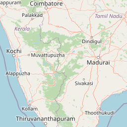
Map view of Pampadum Shola National Park

Use this park location map to pinpoint Pampadum Shola National Park in India, understand its exact geographic position, and read its mapped placement within the surrounding landscape more clearly.

Pigeon | © OpenStreetMap contributors
Park atlas

Compare the regional geography and diverse protected landscapes surrounding Pampadum Shola National Park.

Discover Nearby National Parks and Protected Areas Around Pampadum Shola National Park, Western Ghats.

Browse a curated list of national parks and protected areas geographically close to Pampadum Shola National Park, encompassing the distinctive shola forest and montane ecosystems of the Western Ghats. Comparing these adjacent protected landscapes provides essential context for understanding the conservation efforts and ecological connectivity across this vital biodiversity hotspot.
National parkKerala
About 4.8 km away#1 closest

Northwest

Anamudi Shola National Park: Protected Montane Forest and Wildlife Corridor in Kerala

Explore unique high-altitude ecosystems and regional landscape context.

Anamudi Shola National Park is a compact yet ecologically significant protected area situated in the Western Ghats of Kerala, India. Covering around 7.5 square kilometers, the park preserves rare montane shola forests at elevations exceeding 2,100 meters. Its identity as a critical wildlife corridor, connecting contiguous protected zones, is fundamental to its conservation value. The park's landscape, defined by its unique ecosystems and regional geographic position, offers valuable insights for atlas-driven exploration of protected natural areas.

Area
7.5 km²
Established
2003
IUCN
II
Relief
Mountain
National parkKerala
About 17 km away#2 closest

West

Eravikulam National Park: National Park with Mapped Protected Boundaries in Kerala

Understanding its geographic setting and landscape identity.

Delve into the protected landscape of Eravikulam National Park, a significant national park located in Kerala. This detailed entry focuses on its geographic coordinates, mapped boundaries, and its role as a distinct protected area within the regional geography. It serves as a valuable resource for exploring the park's natural terrain and its importance in conservation landscapes.

Area
97 km²
Established
1978
IUCN
II
Visitors
148.4K annual
National parkIdukki
About 19 km away#3 closest

Southwest

Mathikettan Shola National Park: National Park Exploration and Geographic Mapping

Discover its protected landscape and regional context.

Mathikettan Shola National Park, a designated national park in the Idukki region, offers a focal point for understanding protected landscapes and their geographic distribution. This entry details the park's mapped boundaries and its specific setting within the regional geography, providing an atlas-level view of its conservation value. Users can explore the structured geographic identity of this protected natural area, enriching their understanding of India's park network.

Area
12.82 km²
Established
2003
IUCN
II
Relief
Mountain
Wildlife reserveIndia
About 38 km away#4 closest

Northwest

Anaimalai Tiger Reserve: Wildlife Reserve Park Atlas and Geographic Context in India

Mapping protected landscapes and natural terrain of this Indian wildlife reserve.

Anaimalai Tiger Reserve is a significant wildlife reserve located in India, offering rich opportunities for geographic and atlas-based discovery. This page provides detailed information on its protected area status, mapped boundaries, and the surrounding natural landscape context. Delve into the park's specific geography to understand its role as a conservation area within the broader Indian subcontinent.

National parkKerala
About 63 km away#5 closest

South

Periyar National Park: National Park Protected Area Atlas and Geographic Context

Mapped protected lands and regional landscape exploration in Kerala.

Discover Periyar National Park as a distinct protected landscape offering rich geographic context for atlas exploration. This entry details its mapped boundaries and its significance within the broader regional geography of Kerala. Understand the natural terrain and protected-area distribution that makes Periyar National Park a key element in India's conservation mapping.

Area
350.54 km²
Established
1982
IUCN
II
Visitors
754.3K annual
Protected areaIndia
About 106 km away#6 closest

West

Vembanad Protected Area: Mapping India's Iconic Kerala Backwaters and Wetland Landscape

An extensive inland lake system featuring tidal lagoons, islets, and below-sea-level agricultural plains.

Spanning over 96 kilometers, Vembanad forms a sprawling wetland environment that acts as the primary drainage basin for much of Kerala. Analyze the geography of its intricate shorelines, mangrove patches, and historic islets like Pathiramanal. This protected zone provides a critical habitat for thousands of waterbirds while illustrating the complex relationship between coastal estuaries and human-managed landscapes.

Area
2,033.02 km²
Relief
Lowland
Climate
Tropical
Access
Easy access
Watercolor illustration of green hills, a river, and distant pink mountains
National parkKerala
About 140 km away#7 closest

Northwest

Silent Valley National Park: Kerala's Protected Landscape and Geographic Atlas

Explore mapped boundaries and regional terrain in South India.

Silent Valley National Park stands as a key protected area within Kerala, India, offering rich insights into its geographic setting. This destination provides an atlas-driven view of the park's mapped boundaries, its integration with the surrounding regional geography, and the character of its natural landscapes. Users can engage with detailed information designed for structured exploration of protected natural areas and their mapped contexts.

Area
89.52 km²
Established
1984
IUCN
II
Relief
Mountain
Protected areaKerala
About 141 km away#8 closest

Southwest

Sasthamkotta Lake Protected Area: Geography and Wetland Map Profile

Kerala's largest freshwater wetland and basin landscape

Investigate the territorial profile of Sasthamkotta Lake, an important Ramsar site in Kerala. This resource maps the lake's sheltered basin, shoreline hill contours, and connection to the alluvial plains of the Kallada River, highlighting its critical role in the regional hydrologic network.

Area
3.73 km²
Relief
Lowland
Climate
Tropical
Access
Easy access

Common questions about visiting, size, designation, and location context for Pampadum Shola National Park

Pampadum Shola National Park FAQs for park facts, access, geography, and protected area context

Find quick answers about Pampadum Shola National Park, including protected-area facts, park geography, trail and visitor context, and how the park fits into its surrounding country and regional landscape.
MoriAtlas Explorer

Continue Your Protected Areas Search Across the Global Atlas

Deepen your exploration by continuing the structured search for national parks and protected areas worldwide. Utilize the comprehensive filtering capabilities to compare different conservation landscapes and refine your understanding of global park geography. Discover more about the distribution and characteristics of protected natural areas.

Global natural geography