Mori Atlas logo
National parkPha Daeng National Park

Explore the geographic boundaries and regional context of this national park in Chiang Mai Province.

Pha Daeng National Park: A Mapped Protected Landscape in Northern Thailand's Geography

Pha Daeng National Park offers a distinct protected area within the mountainous terrain of Chiang Mai Province, Northern Thailand. As a national park, its mapped boundaries define a significant natural landscape, providing valuable context for understanding the region's geography. This page serves as a gateway to exploring the specific protected-area identity and geographic setting of Pha Daeng National Park, contributing to a broader atlas of conservation landscapes.

mountain parksnorthern Thailandprotected forestsSoutheast Asian national parksDoi Puk PhakkaDaen Lao Range

Pha Daeng National Park

National park

Park overview

Structured park overview, official facts, and landscape profile for Pha Daeng National Park

Pha Daeng National Park park facts, protected area profile, and essential visitor context
Review the core facts for Pha Daeng National Park, including designation, size, terrain, visitor scale, habitats, and operating context in one park-focused overview.

About Pha Daeng National Park

Pha Daeng National Park occupies a substantial footprint in Chiang Mai Province, covering about 1,123 square kilometres of the Pha Daeng mountain region within the Daen Lao Range. The terrain is characterized by mountainous landscape with peaks reaching nearly 1,800 metres, representing some of the higher elevations in this portion of northern Thailand. The park's location near the Burmese border places it within a broader network of protected areas that includes Chiang Dao Wildlife Sanctuary immediately to the south. This clustering of protected lands helps preserve ecological connectivity in a region where montane forests and diverse habitats face pressure from development and land use changes. The park was designated as Thailand's 99th national park in November 2000, following establishment procedures documented in the Royal Gazette. While the park attracts visitors seeking natural landscapes in northern Thailand, comprehensive documentation of its specific ecological attributes, trail systems, or visitor facilities is limited in the available source material.

Quick facts and research context for Pha Daeng National Park

Pha Daeng National Park spans roughly 1,123 square kilometres in Chiang Mai Province, Thailand, protecting portions of the Daen Lao Range near the Burmese border. The park was established in November 2000 as Thailand's 99th national park, originally under the name Chiang Dao National Park. Its tallest peak, Doi Puk Phakka, reaches 1,794 metres in elevation. The area is managed by Thailand's Department of National Parks, Wildlife and Plant Conservation and received approximately 39,534 visitors in 2024.

Park context

Deeper park guide and search-rich context for Pha Daeng National Park

Pha Daeng National Park history, landscape, wildlife, and travel context
Explore Pha Daeng National Park through its history, landscape character, ecosystems, wildlife, conservation priorities, cultural context, and seasonal travel timing in a structured park guide built for atlas discovery and search intent.

Why Pha Daeng National Park stands out

Pha Daeng National Park is known for its mountainous terrain within the Daen Lao Range, a northern Thai mountain system that extends along the border region. The park protects a significant area of forested mountain landscape, though detailed information about specific notable features, endemic species, or distinctive geological formations is limited in available sources. Its proximity to Chiang Dao Wildlife Sanctuary creates a larger protected corridor in northern Thailand's highland ecosystems.

Pha Daeng National Park history and protected-area timeline

Pha Daeng National Park was officially established on 2 November 2000, when its designation was published in Thailand's Royal Gazette. The park became the 99th national park in Thailand's protected area system at the time of its creation. Prior to this designation, the area was known as Chiang Dao National Park, though the park does not include the Chiang Dao area itself, which is instead protected by the separate Chiang Dao Wildlife Sanctuary. The renaming to Pha Daeng reflected the specific mountain region within the Daen Lao Range that the park encompasses. The establishment of this protected area contributed to Thailand's ongoing efforts to preserve mountainous forest ecosystems in the northern provinces, particularly in regions bordering Myanmar where cross-border ecological considerations apply.

Park location guide

Geography guide, regional context, and park location map for Pha Daeng National Park

Pha Daeng National Park park geography, regions, and map view in Thailand
Understand where Pha Daeng National Park sits in Thailand through a broader geographic reading of the surrounding landscape, nearby location context, and its mapped position within the national park landscape.

How Pha Daeng National Park fits into Thailand

Thailand is a Southeast Asian nation formerly called Siam, located in mainland Southeast Asia. It operates as a unitary parliamentary constitutional monarchy under King Vajiralongkorn. The country borders Myanmar, Laos, Cambodia, and Malaysia, with maritime boundaries involving Vietnam, Indonesia, and India. Thailand has a population of nearly 66 million and covers approximately 513,120 km². Historically, the Sukhothai Kingdom marks the beginning of Thai history, followed by the powerful Ayutthaya Kingdom.

Wider geography shaping Pha Daeng National Park in Thailand

Thailand occupies mainland Southeast Asia with borders to Myanmar (west/northwest), Laos (east/northeast), Cambodia (southeast), and Malaysia (south). The country has coastline along the Gulf of Thailand to the southeast and the Andaman Sea to the southwest. The territory covers approximately 513,120 km².

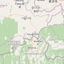
Map view of Pha Daeng National Park

Use this park location map to pinpoint Pha Daeng National Park in Thailand, understand its exact geographic position, and read its mapped placement within the surrounding landscape more clearly.

Pigeon | © OpenStreetMap contributors

Location context for Pha Daeng National Park

Chiang Mai Province
Park atlas

Map additional protected areas in northern Thailand's Daen Lao Range, discovering connected conservation zones.

Explore Nearby Protected Areas and National Parks Near Pha Daeng National Park in Northern Thailand
Discover other national parks and protected areas situated near Pha Daeng National Park, exploring northern Thailand's Daen Lao Range mountainous terrain. This regional view enables comprehensive park comparison, revealing the geographic context of contiguous protected landscapes and highland ecosystems.
National parkMae Hong Son Province

Huai Nam Dang National Park: Northern Thailand's Mountainous Protected Landscape

Explore mapped terrain and protected area boundaries in Mae Hong Son Province.

Huai Nam Dang National Park offers a detailed look into Thailand's mountainous north, featuring rugged terrain characterized by steep slopes and deep valleys. This protected area, a key national park within Mae Hong Son Province, provides a valuable case study for understanding regional geography and landscape context. Its elevation ranges from low-lying valleys to the Doi Chang summit, contributing to its significance as a watershed and natural wilderness.

Area
1,252 km²
Established
1995
IUCN
II
Visitors
121.1K annual
National parkChiang Mai Province

Doi Wiang Pha National Park: Protected Mountainous Terrain and Watershed Dynamics in Northern Thailand

Explore the geography of this vital national park's peaks and valleys.

Doi Wiang Pha National Park stands as a significant national park in Chiang Mai Province, renowned for its dramatic mountainous terrain and its crucial function as a watershed. The park's complex system of ridges and valleys, along with its central peak, Doi Wiang Pha, defines its rugged landscape. Its waters feed into the Fang and Mae Lao river systems, highlighting its ecological importance for regional agriculture and communities. Understanding Doi Wiang Pha National Park through its mapped geography reveals a key protected area within northern Thailand's atlas of natural landscapes.

Area
343.37 km²
IUCN
II
Visitors
939 annual
Relief
Mountain
National parkChiang Mai Province

Si Lanna National Park: A Protected Landscape within Chiang Mai Province

Discover its geographic context and mapped protected area identity.

Si Lanna National Park is a designated national park located in the northern Thai highlands of Chiang Mai Province. This entry provides essential geographic context, detailing the park's mapped boundaries and its place within the regional atlas. Users can explore the protected landscape's characteristics and understand its role in the diverse geography of northern Thailand, serving as a key point for atlas-driven discovery of natural areas.

Area
1,405 km²
Established
1989
IUCN
II
Visitors
89.4K annual
National parkChiang Mai Province

Doi Pha Hom Pok National Park: Protected National Park in Chiang Mai Province's Highlands

Mapped natural landscape and regional geographic context.

Access detailed information about Doi Pha Hom Pok National Park, a key protected area within the expansive Chiang Mai Province. This national park is situated in the Thai highlands, offering a unique perspective on the region's natural terrain and geographic distribution. Understand its specific mapped boundaries and its contribution to the atlas of protected landscapes in northern Thailand.

Area
524 km²
Established
2000
IUCN
II
Visitors
70.1K annual
Illustration showing steep mountain cliffs, a valley filled with clouds, and a waterfall, with pine trees in the foreground and a sun in the sky.
National parkChiang Rai Province

Khun Chae National Park: Protected Landscape and Geographic Detail in Chiang Rai Province

Explore mapped boundaries and natural terrain within Northern Thailand.

Khun Chae National Park is a designated national park offering a focused view of protected landscape geography within Chiang Rai Province. This entry provides structured details on its mapped boundaries and regional geographic context, serving as a key point for atlas-style discovery of Thailand's natural areas. Understand the park's identity as a protected landmass and its contribution to the natural geography of the Thai highlands.

Area
270 km²
Established
1995
IUCN
II
Visitors
11.2K annual
Watercolor landscape featuring mountains, a lake, and trees in the foreground
National parkChiang Rai Province

Lam Nam Kok National Park: Protected Landscape Geography in Chiang Rai Province

Explore the mapped boundaries and regional context of this national park.

Lam Nam Kok National Park stands as a notable protected area within the diverse geography of Chiang Rai Province. This page provides detailed insight into its specific geographic identity, helping users understand its mapped boundaries and its significance as part of Thailand's protected natural landscapes. Discover the park's place within the regional context of the Thai highlands, facilitating a more profound atlas-driven understanding of conservation areas in northern Thailand.

Area
634.87 km²
Established
2002
IUCN
II
Visitors
197.1K annual
National parkThailand

Doi Suthep, Pui National Park: An Atlas View of Thailand's Protected National Landscape

Explore mapped boundaries and regional geographic context.

This entry focuses on Doi Suthep, Pui National Park, detailing its role as a protected national landscape within Thailand. Users can examine its mapped territory and understand its geographic placement and regional significance, offering a focused perspective for atlas exploration and a deeper appreciation of its protected status.

Area
257 km²
Established
1981
IUCN
II
Visitors
328.7K annual
National parkThailand

Doi Luang National Park: Northern Thailand's Extensive Mountain Protected Area

Mapped terrain, forest ecosystems, and watershed significance.

Doi Luang National Park is a substantial protected landscape situated in the Phi Pan Nam Range of Northern Thailand, covering extensive mountainous territory. The park's geographic importance is highlighted by its role in protecting critical headwater ecosystems for both the Wang and Lao Rivers, featuring rugged ridgelines and significant natural terrain. Discover the mapped boundaries and conservation value of this expansive national park, integral to Thailand's regional geography and ecological health.

Area
1,169 km²
Established
1990
IUCN
II
Visitors
41K annual

Common questions about visiting, size, designation, and location context for Pha Daeng National Park

Pha Daeng National Park FAQs for park facts, access, geography, and protected area context
Find quick answers about Pha Daeng National Park, including protected-area facts, park geography, trail and visitor context, and how the park fits into its surrounding country and regional landscape.
MoriAtlas Explorer

Continue Your Protected Areas Search Across the Global Atlas

Deepen your exploration by continuing the structured search for national parks and protected areas worldwide. Utilize the comprehensive filtering capabilities to compare different conservation landscapes and refine your understanding of global park geography. Discover more about the distribution and characteristics of protected natural areas.

Global natural geography