

Mori Atlas logo
National parkPhu Ruea National Park

Discover the geographic boundaries and regional setting of Phu Ruea National Park.

Phu Ruea National Park: A Mapped Protected Landscape in Thailand's Loei Province

Phu Ruea National Park represents a key protected landscape within the mountainous terrain of Loei Province, northeastern Thailand. As a national park, its mapped boundaries offer a distinct geographic focus for atlas exploration. Users can investigate the park's position within the broader regional geography of Isan, understanding its role as a conservation area and a feature on the Thai atlas.

mountain parkshighland ecosystemswaterfallsbirdwatchingpine forestscold-climate parks

Phu Ruea National Park

National park

Park overview

Structured park overview, official facts, and landscape profile for Phu Ruea National Park

Phu Ruea National Park park facts, protected area profile, and essential visitor context
Review the core facts for Phu Ruea National Park, including designation, size, terrain, visitor scale, habitats, and operating context in one park-focused overview.

About Phu Ruea National Park

Phu Ruea National Park occupies a unique position in Thailand's protected area system as one of the nation's premier highland parks, preserving a segment of the Phetchabun Mountains that rises dramatically from the surrounding northeastern plateau. The park's location in Loei Province places it near the border with Laos, giving the landscape a distinctive transboundary character with views extending across the Mekong River valley into the neighboring country. The central peak of Phu Ruea serves as both the park's ecological and symbolic core, its summit plateau supporting pine forests and grassland clearings that create an unusual montane environment within tropical Thailand. Beyond the main peak, the park encompasses additional notable summits including Phusun at 1,035 meters and Phuku at 1,000 meters, creating a complex mountainous terrain characterized by steep slopes, rocky outcrops, and forested ridges. The park's establishment in 1979 reflected growing recognition of the ecological and scenic value of Thailand's highland areas, and today the park provides critical habitat protection within a region where forest cover has declined significantly.

Quick facts and research context for Phu Ruea National Park

Phu Ruea National Park spans 121 square kilometers in Loei Province, northeastern Thailand, within the Phetchabun Mountains. The park's centerpiece, Phu Ruea peak, reaches 1,365 meters and holds the distinction of being Thailand's coldest location, with temperatures dropping below freezing during December and January. The park was established in 1979 and received approximately 169,643 visitors in 2019. The protected area encompasses diverse forest types including mixed deciduous, deciduous dipterocarp, dry evergreen, and coniferous forests, supporting a variety of wildlife and plant species.

Park context

Deeper park guide and search-rich context for Phu Ruea National Park

Phu Ruea National Park history, landscape, wildlife, and travel context
Explore Phu Ruea National Park through its history, landscape character, ecosystems, wildlife, conservation priorities, cultural context, and seasonal travel timing in a structured park guide built for atlas discovery and search intent.

Why Phu Ruea National Park stands out

Phu Ruea National Park is best known for its alpine character and dramatic mountain scenery in a country typically associated with tropical climates. The park contains Thailand's coldest highland environment, where winter temperatures regularly fall below freezing and frost forms on the summit grasslands. The distinctive boat-shaped cliff at the peak gives Phu Ruea its name and serves as an iconic landmark visible from the summit viewpoint, which also provides panoramic vistas across the Mekong River into Laos. The park's waterfalls, particularly the 30-meter Huai Phai waterfall, and its diverse forest ecosystems ranging from dipterocarp lowlands to coniferous montane forests represent additional distinctive features that set this park apart within Thailand's protected area network.

Phu Ruea National Park history and protected-area timeline

Phu Ruea National Park was established on July 26, 1979, as part of Thailand's expanding network of protected areas during the late 1970s and 1980s, a period when the country began systematically designating national parks to preserve outstanding natural landscapes and ecosystems. The creation of the park reflected increasing awareness of the ecological significance of the Phetchabun Mountains and the need to protect the unique highland environment that experiences Thailand's most extreme temperatures. Prior to formal protection, the Phu Ruea area had long been recognized locally as an important scenic and recreational destination, with the distinctive boat-shaped cliff at the summit serving as a landmark for regional communities. The park's establishment followed a broader pattern of national park creation in Thailand's mountainous northern and northeastern regions during this period, with the Department of National Park, Wildlife and Plant Conservation assuming management responsibility for the protected area.

Phu Ruea National Park landscape and geographic character

The landscape of Phu Ruea National Park is defined by its mountainous terrain within the Phetchabun Mountains, characterized by a series of peaks, ridges, and valleys that create a dramatic highland environment distinctly different from Thailand's typical tropical lowlands. The park's central feature, Phu Ruea peak at 1,365 meters, rises above the surrounding landscape with a distinctive cliff formation that resembles the bow of a traditional Thai sailing boat, the feature that inspired the mountain's name meaning 'boat mountain.' The summit plateau supports a mix of pine trees and open grasslands, while the slopes below descend through increasingly dense forest cover. Notable geological features include the large cliff known as Pha Sam Thong and the spectacular waterfalls for which the park is known, with the Huai Phai waterfall dropping 30 meters representing the tallest cascade within the park's boundaries. The landscape offers sweeping views from the summit across the Mekong and Hueang River valleys to the distant mountains of Laos, creating a panoramic vista that attracts visitors seeking the distinctive experience of alpine scenery within Thailand.

Phu Ruea National Park ecosystems, habitats, and plant life

The ecological character of Phu Ruea National Park reflects its unique position as a montane refuge within Thailand's northeastern highlands, where elevation creates conditions that support forest types more commonly associated with higher latitudes. The park contains several distinct forest communities including mixed deciduous forest, deciduous dipterocarp forest, dry evergreen forest, and coniferous forest, with the coniferous elements becoming more prominent at higher elevations around the summit. The diversity of forest types within a relatively compact area creates a complex ecological mosaic that supports varied plant and animal communities. The park's flora includes numerous orchid species such as Phalaenopsis pulcherrima, Rhynchostylis retusa, and various Vanda and Dendrobium varieties, alongside rhododendrons including Rhododendron simsii and Rhododendron lyi. The montane environment also supports mosses, ferns, and wild roses in the lower vegetation layers, creating conditions that feel distinctly different from Thailand's tropical lowland forests.

Phu Ruea National Park wildlife and species highlights

The wildlife community within Phu Ruea National Park reflects the park's diverse habitats and its position as a relatively intact forest area within Thailand's northeastern region. Mammals present in the park include sun bear, northern red muntjac, sambar deer, dhole (wild dog), black giant squirrel, and Siamese hare, representing a mix of lowland and montane species adapted to the various forest types within the protected area. The bird fauna includes red junglefowl, the distinctive Siamese fireback pheasant, yellow-vented bulbul, greater coucal, plain prinia, coppersmith barbet, Asian barred owlet, and brown-throated sunbird, providing opportunities for bird observation throughout the park's diverse habitats. Notably, the endangered big-headed turtle has been recorded within the park, representing a species of conservation concern whose presence indicates the ecological significance of the area's aquatic habitats. The combination of forest types from lowland dipterocarp to montane coniferous creates a gradient of habitats that supports this diversity of wildlife species.

Phu Ruea National Park conservation status and protection priorities

Phu Ruea National Park serves as an important conservation unit within Thailand's protected area network, preserving a representative sample of the Phetchabun Mountain ecosystem and providing habitat protection for species of conservation concern in northeastern Thailand. The park's designation as an IUCN Category II protected area reflects its primary mandate of preserving natural landscapes while allowing for sustainable recreation and environmental education. The diverse forest types represented within the park, including old-growth dipterocarp forest, dry evergreen forest, and coniferous forest, contain ecological communities that have faced significant pressure from logging, agricultural expansion, and infrastructure development across the broader region. Protection of the Phu Ruea area ensures the preservation of watershed functions critical for downstream communities and maintains habitat connectivity for wildlife populations moving between the higher mountains and lowland areas. The presence of the endangered big-headed turtle highlights the park's significance for species that require both aquatic and terrestrial habitats.

Phu Ruea National Park cultural meaning and human context

Phu Ruea holds significance in local Thai culture and tradition, with the mountain's distinctive shape inspiring its name and serving as a landmark for communities throughout the Loei region. The local name 'แม่คะนิ้ง' (Mae Kaning) reflects the mountain's traditional importance in the cultural landscape of the region. The park's proximity to Laos creates a transboundary character to the landscape, with the panoramic views from the summit extending across the international border and reinforcing the interconnected nature of the broader Mekong region. The area has historically served as a recreational destination for Thai visitors seeking escape from the tropical heat, with the mountain's cool climate representing a major attraction that draws visitors year-round. The regional context includes the province's growing reputation for cultural tourism and local products, with Phu Ruea serving as a natural complement to the cultural experiences available in Loei Province.

Top sights and standout views in Phu Ruea National Park

The summit of Phu Ruea peak offers the park's most dramatic experience, providing panoramic views across the Mekong River valley to the mountains of Laos, particularly striking during clear weather. The distinctive boat-shaped cliff formation at the summit provides both the park's name and its most recognizable landmark, with visitors ascending to experience this unique geological feature. The Huai Phai waterfall, at 30 meters the park's tallest cascade, represents a major attraction, while additional waterfalls including Huai Toei and the tiered Hin Sam Thong offer further aquatic scenery. The diverse forest environments, ranging from pine-covered summit to dipterocarp lowlands, create varied hiking experiences through distinct ecological zones. Winter visitors may experience the rare phenomenon of frost forming on the summit grasslands, an extraordinary occurrence within Thailand's tropical environment.

Best time to visit Phu Ruea National Park

The optimal time to visit Phu Ruea National Park spans from October through March, coinciding with the cool dry season when temperatures are at their most comfortable and the highland environment displays its distinctive character. The winter months of December and January offer the coldest conditions, with temperatures at the summit potentially falling below freezing and frost occasionally forming on the grass, creating a remarkable alpine atmosphere unusual in Thailand. During this period, morning mist and clear skies often provide excellent visibility for the panoramic views from the summit. The shoulder months of October and November offer pleasant temperatures with the advantage of fewer crowds, while February and March still provide cool conditions with increasingly stable weather. The wet season from April through September brings higher temperatures and increased rainfall, though the park remains accessible and the landscape remains green during this period.
Park location guide

Geography guide, regional context, and park location map for Phu Ruea National Park

Phu Ruea National Park park geography, regions, and map view in Thailand
Understand where Phu Ruea National Park sits in Thailand through a broader geographic reading of the surrounding landscape, nearby location context, and its mapped position within the national park landscape.

How Phu Ruea National Park fits into Thailand

Thailand is a Southeast Asian nation formerly called Siam, located in mainland Southeast Asia. It operates as a unitary parliamentary constitutional monarchy under King Vajiralongkorn. The country borders Myanmar, Laos, Cambodia, and Malaysia, with maritime boundaries involving Vietnam, Indonesia, and India. Thailand has a population of nearly 66 million and covers approximately 513,120 km². Historically, the Sukhothai Kingdom marks the beginning of Thai history, followed by the powerful Ayutthaya Kingdom.

Wider geography shaping Phu Ruea National Park in Thailand

Thailand occupies mainland Southeast Asia with borders to Myanmar (west/northwest), Laos (east/northeast), Cambodia (southeast), and Malaysia (south). The country has coastline along the Gulf of Thailand to the southeast and the Andaman Sea to the southwest. The territory covers approximately 513,120 km².

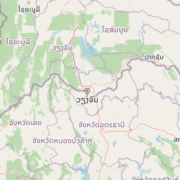
Map view of Phu Ruea National Park

Use this park location map to pinpoint Phu Ruea National Park in Thailand, understand its exact geographic position, and read its mapped placement within the surrounding landscape more clearly.

Pigeon | © OpenStreetMap contributors

Location context for Phu Ruea National Park

Loei Province
Park atlas

Compare additional mountain parks, highland ecosystems, and protected landscapes across northeastern Thailand.

Explore Nearby National Parks and Protected Areas Surrounding Phu Ruea National Park
Continue exploring Thailand's diverse protected areas by browsing national parks and highland ecosystems situated geographically near Phu Ruea National Park. Trace distinctive mountain terrain, dramatic waterfalls, and cold-climate landscapes across the Phetchabun Mountains and broader regional geography, comparing key conservation landscapes.
National parkPhitsanulok Province

Namtok Chat Trakan National Park: Protected Mountain Forests and River Headwaters in Phitsanulok Province

Discover mapped geography and unique protected landscape features.

Namtok Chat Trakan National Park protects over 543 square kilometers of mountainous dipterocarp forest within Phitsanulok Province, Thailand. Established in 1987, it is recognized for its role as a vital watershed area, safeguarding the headwaters of the Khwae Noi River system. The park's rugged terrain, dense forests, and prominent waterfalls, including the multi-tiered Chat Trakan cascade, provide a distinct geographic identity. Explore the mapped boundaries and natural landscape of this significant protected area.

Area
543 km²
Established
1987
IUCN
II
Visitors
13K annual
National parkThailand

Phu Hin Rong Kla National Park: A Protected Mountain Landscape in Northern Thailand

Explore rock formations, waterfalls, and unique historical terrain.

Phu Hin Rong Kla National Park, situated in northern Thailand, is a significant national park known for its dramatic mountainous terrain, including impressive fractured rock formations and numerous multi-tiered waterfalls. This protected area also holds historical importance, having served as a former communist insurgent stronghold. Its rugged landscape is defined by steep ridges, deep valleys, and diverse forest ecosystems, making it a compelling destination for understanding Thailand's natural and historical geography within a mapped context.

Area
307 km²
Established
1984
IUCN
II
Visitors
289.2K annual
National parkLoei Province

Phu Kradueng National Park: Sandstone Mesa Protected Landscape and Geographic Atlas

Discover mapped boundaries and pine savanna terrain.

Phu Kradueng National Park, situated in Loei Province, Thailand, is a remarkable protected area defined by its large sandstone mesa and striking cliff-edged summit plateau. This page offers detailed geographic insights into the park's unique landscape, including its pine savanna ecosystems, diverse forest types transitioning from lower slopes to the summit, and its cool, refreshing climate. Explore Phu Kradueng National Park's mapped boundaries and natural terrain for a deeper understanding of this significant conservation landscape.

Area
348 km²
Established
1962
IUCN
II
Visitors
86.3K annual
National parkPhetchabun Province

Nam Nao National Park: Protected Landscape and Regional Geography

Explore maps and natural terrain of this Northern Thailand park.

Nam Nao National Park, situated in Phetchabun Province, Thailand, is a large national park distinguished by its rugged mountainous terrain and extensive pine forest landscapes. This protected area is vital for its role in conservation, housing significant biodiversity and forming a natural boundary between regions. Through its mapped geography and diverse natural settings, Nam Nao National Park offers a key destination for understanding protected land dynamics and regional natural landscapes.

Area
966 km²
Established
1972
IUCN
II
Visitors
31.8K annual
National parkPhitsanulok Province

Thung Salaeng Luang National Park: A Protected National Park in Phitsanulok Province

Explore its mapped geography and natural landscape context.

Delve into Thung Salaeng Luang National Park, a designated national park situated in the Phitsanulok Province region of Thailand. This detail page focuses on its protected landscape features, mapped boundaries, and the surrounding geographic context, providing essential information for atlas-driven exploration and understanding of conservation areas. Understand the unique natural terrain and regional significance of this park entity.

Area
1,262 km²
Established
1963
IUCN
II
Visitors
52.1K annual
National parkPhetchabun Province

Khao Kho National Park: Protected Landscape Geography and Mapped Boundaries

Discover natural terrain within Phetchabun Province.

Gain insight into Khao Kho National Park, a key protected area situated in Phetchabun Province, Thailand. This entry focuses on its geographic significance, mapped park boundaries, and its place within the diverse landscapes of lower northern Thailand. Explore the atlas-ready details that define Khao Kho National Park as a distinct protected landscape, offering a clear view of its regional context and natural terrain.

Area
483 km²
Established
2012
IUCN
II
Visitors
33.6K annual
National parkThailand

Lam Nam Nan National Park: Thailand's National Park Identity for Atlas Exploration

Explore the mapped geography and protected landscape of this Thai national park.

Lam Nam Nan National Park serves as a focal point for understanding Thailand's protected areas and their geographic distribution. This detail page facilitates atlas-style exploration, highlighting the park's specific landscape context and its mapped boundaries within the broader region. Users can gain insight into the protected natural terrain and its significance for regional geography and conservation landscape studies.

Area
999 km²
Established
1998
IUCN
II
Visitors
27.9K annual
National parkNan Province

Si Nan National Park: A Protected Landscape within Nan Province's Geography

Discover mapped boundaries and regional terrain context.

Delve into the geographic identity of Si Nan National Park, a protected national park situated in Thailand's Nan Province. This destination provides focused access for exploring its mapped boundaries and understanding its place within the broader regional geography. It serves as a critical point for discovering the natural landscape and protected-area details relevant to atlas and map-based research.

Area
1,024 km²
Established
2007
IUCN
II
Visitors
115.4K annual

Common questions about visiting, size, designation, and location context for Phu Ruea National Park

Phu Ruea National Park FAQs for park facts, access, geography, and protected area context
Find quick answers about Phu Ruea National Park, including protected-area facts, park geography, trail and visitor context, and how the park fits into its surrounding country and regional landscape.
MoriAtlas Explorer

Continue Your Protected Areas Search Across the Global Atlas

Deepen your exploration by continuing the structured search for national parks and protected areas worldwide. Utilize the comprehensive filtering capabilities to compare different conservation landscapes and refine your understanding of global park geography. Discover more about the distribution and characteristics of protected natural areas.

Global natural geography