Peaks
Morra de Lechugales
2,444 m

Detailed landscape analysis across the Asturias, Castile and Leon, and Cantabria regions
Examine the physical composition of Picos de Europa National Park, spanning 671.27 square kilometers across three Spanish regions. This profile details the mountain relief, elevation range from 75 to 2648 meters, and associated stream and valley systems within the protected boundaries.
Spain's first national park, protecting the limestone peaks and Atlantic forests of the Cantabrian Mountains
Picos de Europa National Park is Spain's oldest national park, established in 1918 in the dramatic limestone mountain range of the same name within the Cantabrian Mountains of northern Spain. The park spans approximately 671 square kilometers across three autonomous communities—Asturias, Cantabria, and Castile and León—making it one of the most significant protected areas in Spain. The landscape is characterized by towering limestone peaks, glacial valleys, deep ravines, and pristine lakes, with an extraordinary vertical drop of nearly 2,600 meters from the highest summit to the lowest river valley. In addition to its natural significance, the park holds UNESCO Biosphere Reserve status and represents one of the finest examples of Atlantic forest ecosystems in Europe, sheltering remarkable biodiversity including several endangered species such as the Cantabrian brown bear and the bearded vulture.
Regional placement across Asturias, Castile and León, and Cantabria
Interactive boundary geometry and calculated spatial measurements
Mountain relief metrics and recorded natural features
Peaks
2,444 m
Peaks
2,000 m
Peaks
2,564 m
Mountain saddles
1,296 m
Peaks
2,518 m
Peaks
2,614 m
Temperate climate zones, mountain relief, and broadleaf forest coverage data
Mountains · Forest · Rivers · Glacier · Lakes
Temperate broadleaf forest
Compare national parks and protected landscapes across the Cantabrian Mountains, expanding your geographic discovery beyond Picos de Europa National Park.
North

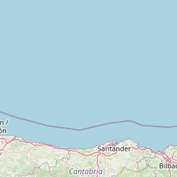
Offshore protected landscapes and deep sea terrain mapping
El Cachucho represents a critical offshore protected area, defined by its massive seamount structure and proximity to the Asturian coastline. This marine habitat encompasses a complex array of geomorphological features, including rocky escarpments and submarine canyons that channel sediment across the narrow northern Iberian shelf, offering a detailed perspective on deep sea environmental architecture.
West
Mapping the Sierra de Ancares river valleys in Provincia de León
Examine the geographic layout and protected boundaries of the Reserva de la biosfera de los Ancares Leoneses. This biosphere reserve serves as a critical mountain corridor, featuring complex river basins and diverse forest cover that highlight the region's environmental and cultural history across the Spanish highlands.
West
Mountainous terrain and river valley geography in Lugo, Spain
This protected area covers the dramatic Sierra de Ancares, featuring steep mountain slopes and deep river valleys that define the geography of Galicia. The reserve spans a significant vertical relief, providing essential habitats for brown bears and capercaillie while preserving traditional rural mountain land use systems and ancient forest ecosystems.
Southeast
Ancient juniper woodlands and deep limestone ravines in Castilla y León.
This protected area centers on the remarkable juniper forests and the narrow, vertical walls of the La Yecla gorge. The landscape serves as an essential habitat for cliff-nesting raptors while bridging the terrain between the Sierra de la Demanda foothills and the Arlanza River basin. The map captures the geological diversity of these limestone structures and the expansive botanical value found within this significant Spanish natural entity.
East
Mapping wetlands, forests, and cliffs in the Basque Country
Explore the complex terrain of Reserva de la biosfera de Urdaibai, spanning the tidal Oka estuary to the peaks of Mount Oiz. This protected landscape is defined by its vast saltmarshes, Cantabrian oak forests, and dramatic coastal cliffs that anchor the natural geography of the Basque Country.
West
Extensive riverine forests and wetland networks in northwestern Spain
Explore the expansive territory of Reserva de la biosfera de las Tierras del Miño, spanning a large portion of the Galician interior. This protected area features a mosaic of wetlands, riparian corridors, and mountainous terrain, offering a deep look into the ecological and cultural geography of the upper Miño river basin.

Southwest

Explore mapped boundaries and regional landscape context.
Montesinho Natural Park is designated as a protected landscape in northeastern Portugal, located within the administrative region of Bragança District. This page serves as an entry point to understanding the park's protected area characteristics, its mapped geographic footprint, and its role in the broader natural landscape of the Trás-os-Montes region. Discover the atlas value of this significant protected territory and its relation to surrounding geography.
Southeast
A biosphere reserve featuring limestone gorges and dinosaur fossil sites
Valles del Jubera, Leza, Cidacos y Alhama forms a distinct mid-mountain region in northern Spain where four river valleys have carved deep passages into the earth. The area serves as a vital protected landscape containing rich paleontological history, thermal springs, and traditional Mediterranean forests. This atlas entry details the natural boundaries and geographic character of one of Spain's significant biosphere reserves.
Delve deeper into the specific geography and protected landscape characteristics of Picos de Europa National Park. Understanding its terrain, ravine systems, and the distribution of its unique Atlantic forest cover offers crucial insight for anyone exploring Spain's natural atlas and its preserved mountain environments. Continue your structured discovery of this significant protected area and its surrounding context.