
Mori Atlas logo
Nature reserveNaturschutzgebiet Piusberg

Examining the ecological landscape, rendzina soils, and cliff habitats of this North Rhine-Westphalia protected area

Naturschutzgebiet Piusberg Nature Reserve: A Detailed Atlas of Limestone Cliffs and Calcareous Grasslands

Naturschutzgebiet Piusberg is a compact nature reserve located near Warstein in North Rhine-Westphalia, Germany. This 8.3 hectare site protects a rare mosaic of near-vertical limestone cliffs, shallow rendzina soils, and species-rich calcareous grasslands. The reserve serves as a critical stepping-stone habitat within the Arnsberger Wald region, bridging urban influences and agricultural terrain to preserve specialized cliff and scrub ecosystems.

limestone cliffcalcareous grasslandnature reserveNorth Rhine-WestphaliaArnsberger Waldscrub habitat
A stylized flat illustration of a grassy hill with a cross at the summit, surrounded by rolling green hills, scattered trees, and a pale sun in a soft sky.

Naturschutzgebiet Piusberg

Nature reserve

Park overview

Structured park overview, official facts, and landscape profile for Piusberg Nature Reserve

Piusberg Nature Reserve park facts, protected area profile, and essential visitor context

Review the core facts for Piusberg Nature Reserve, including designation, size, terrain, visitor scale, habitats, and operating context in one park-focused overview.

About Piusberg Nature Reserve

Piusberg Nature Reserve is a small but ecologically dense protected site located on the southeastern edge of the town of Warstein in the district of Soest, in the German state of North Rhine-Westphalia. Covering about 8.3 hectares, the reserve is built around a prominent limestone outcrop whose near-vertical northern face is one of its defining physical features, while the gentler southern slope supports an unusually rich mosaic of semi-natural grassland.

The reserve was formally proclaimed as a Naturschutzgebiet in 2000 through an ordinance of the Bezirksregierung Arnsberg. Its designation specifically targets the preservation of cliff habitats with their typical biotic communities, calcareous semi-dry grasslands, calcareous dry grasslands on moisture-variable soils, and blackthorn hawthorn scrub communities. Together these habitat types form a compact representative example of calcareous ecosystems in the broader Arnsberger Wald region.

The mosaic of physical conditions at Piusberg is unusually varied for such a small site. Thin rendzina soils on the southern slopes support species-rich lean meadows, while hawthorn bushes dominate the steep northern edge, interspersed with individual shrubs and hedgerow structures that subdivide the grassland. These habitat patterns host warmth-loving species that are otherwise uncommon in the intensively used surrounding landscape, where arable land, settlements, and the active Hillenberg limestone quarry border the reserve.

Despite its compact size, the reserve is recognized as ecologically representative and valuable beyond its own boundaries. Regional ecological assessments classify the biotope complex as highly representative within the natural area and identify it as a key stepping-stone habitat linking other field copses and nutrient-poor grassland sites in the region. This combination of geological, botanical, and structural diversity explains why Piusberg, though small, carries a conservation weight disproportionate to its area.

Quick facts and research context for Piusberg Nature Reserve

Piusberg Nature Reserve covers approximately 8.3 hectares just southeast of the town of Warstein in Kreis Soest, North Rhine-Westphalia. It was legally designated as a nature reserve (Naturschutzgebiet) in the year 2000 by the Bezirksregierung Arnsberg.

The protected site is built around a steep limestone rock complex with a near-vertical northern face and gentler southern slopes. Its habitat mosaic combines cliff communities, calcareous grasslands on rendzina soils, and hawthorn and blackthorn scrub, making it a representative example of calcareous habitat conservation in the area.

Protection and recognition

Documented territory management scope and international designation records

Naturschutzgebiet Piusberg Protection Status and Terrestrial Conservation Details

Terrestrial protection status records outline the documented management scope established for Naturschutzgebiet Piusberg. Available administrative data provides foundational context regarding its official conservation framework and designated boundaries.

Protection details

Protection scope
Terrestrial
Park context

Deeper park guide and search-rich context for Piusberg Nature Reserve

Piusberg Nature Reserve history, landscape, wildlife, and travel context

Explore Piusberg Nature Reserve through its history, landscape character, ecosystems, wildlife, conservation priorities, cultural context, and seasonal travel timing in a structured park guide built for atlas discovery and search intent.

Why Piusberg Nature Reserve stands out

Piusberg is best known for its steep limestone cliff face and the species-rich calcareous dry grasslands that cover its southern flank. The combination of exposed rock, thin rendzina soils, and structured hedgerow vegetation makes the reserve a textbook example of small-scale calcareous habitat protection in the Warstein area. The site also stands out as a refuge for warmth-loving plant and animal communities and is recognized by regional authorities as a valuable stepping-stone habitat in the wider network of field copses and nutrient-poor grassland sites in the Arnsberger Wald.
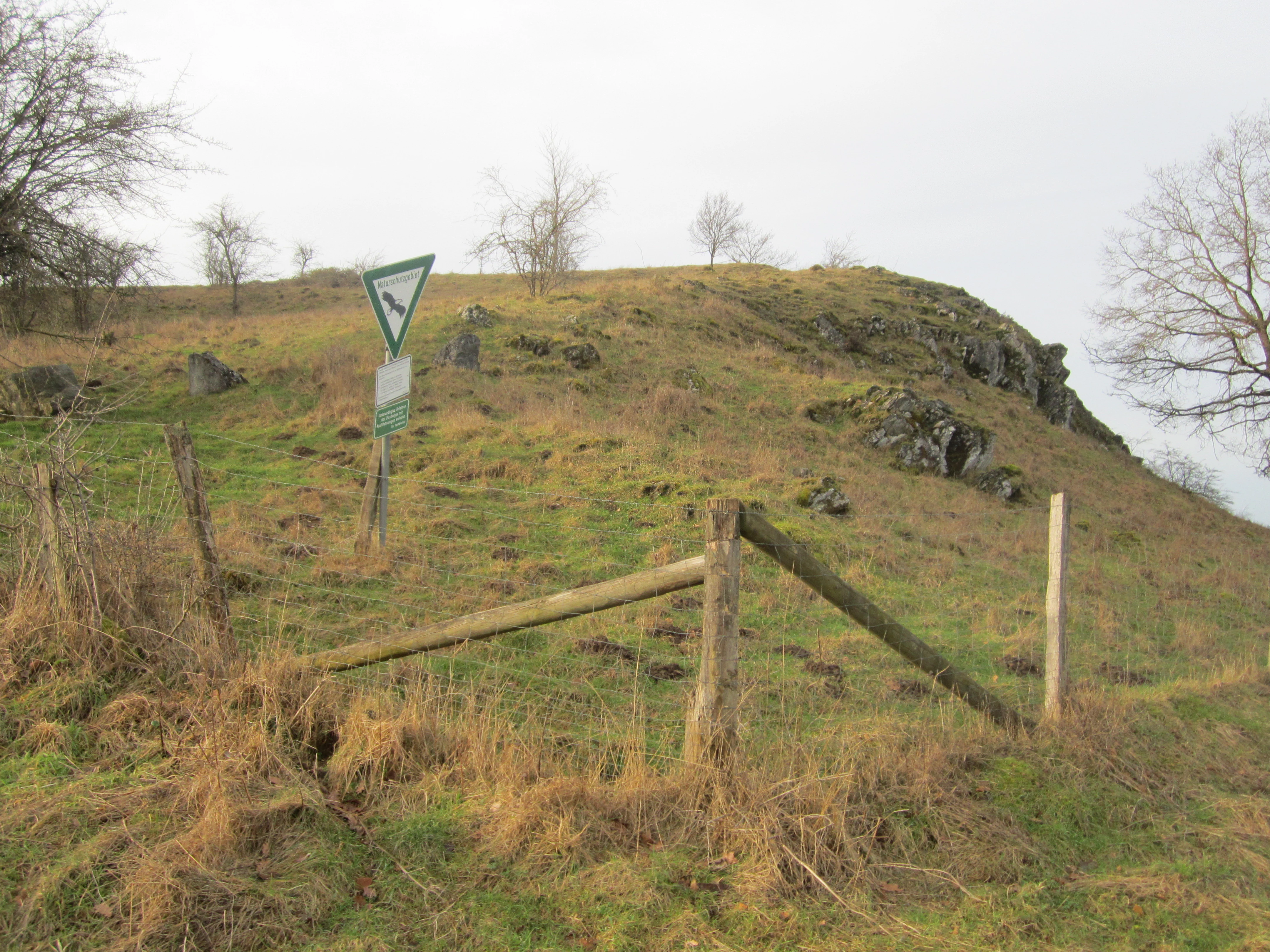
A triangular nature reserve sign stands on a grassy slope with limestone rock outcrops and a wooden fence.
A nature reserve sign marks the landscape at the Piusberg nature reserve.

Piusberg Nature Reserve history and protected-area timeline

The area that is today Piusberg Nature Reserve was brought under formal protection in the year 2000, when the Bezirksregierung Arnsberg issued an ordinance designating roughly 8.3 hectares south-east of Warstein as a Naturschutzgebiet. The legal designation specifically cited the need to preserve cliff communities, calcareous semi-dry grasslands, calcareous dry grasslands on moisture-variable soils, and blackthorn hawthorn scrub as core conservation targets.

At the time of designation, the area was already recognized as containing vegetationally valuable and species-rich calcareous grasslands. The reserve was thus not created from scratch as restored habitat but rather formalized and consolidated protection for a landscape that had retained elements of traditional, nutrient-poor grassland management. Its position on the edge of Warstein, adjacent to a working limestone quarry, made its formal recognition an important step in protecting a highly localized natural feature against further loss to urban expansion or extractive activity.

Piusberg Nature Reserve landscape and geographic character

The defining landscape feature of Piusberg is its steep limestone rock complex. The northern edge of the outcrop drops almost vertically, creating cliff-like exposure that contrasts strongly with the gentler southern flank of the hill. Toward the east, the elevation drops more gradually, producing a varied terrain gradient within a very compact area.

The southern slopes are mantled with shallow rendzina soils, typical of calcareous substrates, which support unusually species-rich lean meadows. These open grassy areas are broken up by individual shrubs and hedgerow structures that follow the contours of the slope. The steep northern face, in contrast, is largely covered by hawthorn scrub that clings to the rock.

The reserve sits in a clearly human-influenced landscape. The town of Warstein lies immediately to the northwest, while the active Hillenberg limestone quarry is directly adjacent along the southern boundary. Beyond these edges, the reserve is mostly surrounded by grassland, placing the cliff and meadow complex in close contact with the open agricultural landscape characteristic of the region.

Piusberg Nature Reserve ecosystems, habitats, and plant life

Ecologically, Piusberg is shaped by the interplay of calcareous bedrock, thin soils, and a long history of low-intensity land use. The site's habitats are dominated by four key community types that are explicitly listed in its designation ordinance: cliff biotic communities, calcareous semi-dry grasslands, calcareous dry grasslands on moisture-variable soils, and blackthorn hawthorn scrub.

Together these form a biotope complex of high regional representativeness. The species-rich calcareous meadows on the southern slope are considered especially valuable at the vegetation-science level, while the cliff and scrub habitats contribute structural diversity. The mosaic supports warmth-loving species that depend on the combination of exposed rock, lean grassland, and shrub structures, all of which are scarce in the wider intensively farmed landscape of the region.

The reserve also functions as a stepping-stone habitat that links other field copses and nutrient-poor grassland fragments in the area. In this way, the nature of the site is defined not only by what grows within its 8.3 hectares but also by its ecological role in the surrounding habitat network.

Piusberg Nature Reserve wildlife and species highlights

Detailed species data for the fauna of Piusberg is limited in the available sources. The reserve is recognized as a habitat suitable for warmth-loving species, particularly bird groups associated with hedges and scrub. These hedge-breeding and bush-breeding bird communities benefit from the structured hawthorn stands along the northern cliff edge and from the hedgerow elements that subdivide the southern meadows.

The combination of cliff exposure, scrub, and open calcareous grassland creates a setting in which thermophilic invertebrates and other warmth-dependent animal groups can also persist, though specific inventories are not documented in the source material. The reserve's broader ecological significance for wildlife lies more in the habitat structures it offers than in any single charismatic flagship species.

Piusberg Nature Reserve conservation status and protection priorities

The conservation value of Piusberg lies in the representativeness of its biotope complex and in its role within the wider calcareous habitat network of the Arnsberger Wald region. The official biotope register of North Rhine-Westphalia describes the reserve as highly representative of its natural area and therefore worthy of protection under regional conservation objectives.

Its core values are identified as the cliff habitats, the hedgerow and scrub structures, and the species-rich calcareous grasslands. These are explicitly recognized as the features that make the site worth protecting. The designation ordinance also points to the reserve's importance as a stepping-stone habitat connecting field copses and other nutrient-poor sites in the area.

Current pressures on the site appear relatively modest but are nonetheless noted. Light trampling damage has been observed in places, suggesting that visitor pressure from the adjacent town of Warstein is one of the manageable impacts the reserve must accommodate. The proximity of the active Hillenberg limestone quarry on the southern boundary is a defining element of the reserve's setting and is part of the broader managed landscape context within which conservation here operates.

Piusberg Nature Reserve cultural meaning and human context

Piusberg sits at the boundary between the natural environment and the heavily shaped cultural landscape of the Warstein area. The town of Warstein lies immediately to the northwest, and the working Hillenberg limestone quarry forms the southern boundary of the reserve, providing a direct context of long-standing quarrying of the local limestone.

This juxtaposition of cliff, meadow, settlement, and active industrial extraction is characteristic of how small nature reserves in the region exist within an intensively shaped landscape rather than as remote wilderness. The reserve itself preserves fragments of traditional nutrient-poor grassland that reflect older land use patterns, in contrast to the surrounding modern agricultural and urban land.

Top sights and standout views in Piusberg Nature Reserve

The most distinctive feature of Piusberg is the rare combination, within just 8.3 hectares, of a near-vertical limestone cliff, species-rich calcareous grassland on rendzina soils, and structured hawthorn scrub. This compressed mosaic is unusual in the region and is the reason the site carries such disproportionate ecological weight.

Equally notable is the reserve's role as a stepping-stone habitat within the wider network of field copses and nutrient-poor grassland sites. Even though it is bordered by urban Warstein on one side and an active quarry on the other, it retains a representative and ecologically valuable biotope complex, making it a small but instructive example of calcareous habitat protection in North Rhine-Westphalia.

Best time to visit Piusberg Nature Reserve

Because the reserve is small and defined by permanent physical and ecological features rather than seasonal events, it can be appreciated throughout the year. Late spring and early summer are typically the most rewarding periods for visitors interested in the species-rich calcareous grasslands, when lean meadow vegetation is at its most floristically expressive. In warmer months the warmth-loving character of the cliff and scrub habitats is also most apparent, while the structural profile of the cliff and the hawthorn stands remains visible year-round.

Visitors should be aware that the site is a working nature reserve in active agricultural and quarrying surroundings rather than a developed visitor destination, and that light trampling damage has been noted by the authorities, so consideration for the fragile grassland is important at any season.

Monthly climate preview

Long-term temperature and precipitation averages recorded at a representative coordinate

Naturschutzgebiet Piusberg Climate Normals and Annual Weather Rhythms

Historical climate normals trace the measured annual temperature and precipitation rhythm across twelve distinct monthly intervals at Naturschutzgebiet Piusberg. Reviewing these long-term averages provides essential geographic context for understanding regional weather patterns without relying on live forecasts.
Annual mean9 °C
0 °C18 °C
Jan
Feb
Mar
Apr
May12°
Jun16°
Jul18°
Aug18°
Sep14°
Oct
Nov
Dec
Warmest month
July

18.2 °C

Coolest month
January

0.3 °C

Wettest month
December

2.7 mm/day

Driest month
April

1.7 mm/day

Park location guide

Geography guide, regional context, and park location map for Piusberg Nature Reserve

Piusberg Nature Reserve park geography, regions, and map view in Germany

Understand where Piusberg Nature Reserve sits in Germany through a broader geographic reading of the surrounding landscape, nearby location context, and its mapped position within the national park landscape.

How Piusberg Nature Reserve fits into Germany

Germany is a federal republic in Western and Central Europe with a population of over 83 million across sixteen constituent states. It is Europe's largest economy by nominal GDP and a major global exporter and importer. The capital is Berlin, and the country borders Denmark, Poland, Czech Republic, Austria, Switzerland, France, Luxembourg, Belgium, and the Netherlands.

Wider geography shaping Piusberg Nature Reserve in Germany

Germany is located in Western and Central Europe, spanning 357,022 km². It borders Denmark to the north, Poland and the Czech Republic to the east, Austria and Switzerland to the south, and France, Luxembourg, Belgium, and the Netherlands to the west. The country has coastlines on the Baltic Sea and North Sea to the north, with the Alps located in the southern region.

Map view of Piusberg Nature Reserve

Use this park location map to pinpoint Piusberg Nature Reserve in Germany, understand its exact geographic position, and read its mapped placement within the surrounding landscape more clearly.

Pigeon | © OpenStreetMap contributors

Location context for Piusberg Nature Reserve

North Rhine-Westphalia

Visualizing the limestone cliffs, calcareous grasslands, and terrain of Piusberg

Naturschutzgebiet Piusberg Landscape Photos and Protected Area Scenery

Visual documentation captures the steep limestone cliff face, shallow rendzina soils, and species-rich calcareous grasslands that characterize the protected area. Examining field photography reveals the distinct topography, scrub vegetation, and habitat structure of the reserve within the Warstein region.

A triangular nature reserve sign stands on a grassy slope with limestone rock outcrops and a wooden fence.

A wide, grassy meadow leading up to a low, gentle hill in the Piusberg nature reserve, with sparse trees and an overcast sky.

Park atlas

Compare adjacent limestone habitats and regional conservation networks

Other Parks Near Naturschutzgebiet Piusberg and Regional Protected Areas

Browse protected areas and natural reserves located near Naturschutzgebiet Piusberg to examine regional limestone geology and local habitat networks. Expanding the geographic scope reveals connected protected landscapes and similar calcareous ecosystems across the surrounding terrain.
Nature reserveNorth Rhine-Westphalia
About 4.7 km away#1 closest

South

Naturschutzgebiet Oberes Lörmecketal: Protected Valley Landscapes in North Rhine-Westphalia

Swamp woodland and brook headwater geography

Delve into the landscape composition of Naturschutzgebiet Oberes Lörmecketal, a small yet ecologically significant nature reserve in the Sauerland. This record details the spring-fed valley terrain, alder-dominated wetlands, and the protected brook corridor that serves as a vital connecting point within the regional Natura 2000 network.

Area
0.03 km²
Established
1994
Relief
Upland
Climate
Temperate
A soft, pastel-toned watercolor painting of a rolling rural landscape with low hills, sparse trees, and a winding path.
Nature reserveNorth Rhine-Westphalia
About 8.4 km away#2 closest

South

Naturschutzgebiet Schnettenberg: Protected Juniper Heath and Ridge Geography in Sauerland

Historic German nature reserve in North Rhine-Westphalia

Covering more than 1,000 metres of ridge terrain, this nature reserve maintains essential dry grassland and juniper communities within the Hochsauerlandkreis. The area provides a vital study of transition zones between open farmland and wooded valley slopes, illustrating the ongoing conservation of light-dependent habitats in modern Germany.

Area
0.045 km²
Established
1938
IUCN
IV
Nature reserveHochsauerlandkreis
About 9.7 km away#3 closest

South

Naturschutzgebiet Ostenberg: Protected Nature Reserve and Cave System Geography

Upland forest terrain and karst geology in Hochsauerlandkreis

Naturschutzgebiet Ostenberg is a significant 21-hectare nature reserve that safeguards a complex of steep-slope forests and a multi-level limestone cave system. The site offers a detailed view into the karst processes and mature woodland ecology characteristic of the Sauerland region, providing a protected habitat for forest flora and wintering bat colonies.

Area
0.211 km²
Established
2008
Relief
Upland
Climate
Temperate
Nature reserveNordrhein-Westfalen
About 9.9 km away#4 closest

Southeast

Naturschutzgebiet Ochsenberg: Landscape and Geographic Profile of a German Nature Reserve

Examining forest reclamation on historic slate mine terrain

Located in the Hochsauerlandkreis, Naturschutzgebiet Ochsenberg serves as a case study in ecological succession. The reserve features an intricate mosaic of oak and beech woodland established over old spoil tips, while its abandoned mine tunnels remain essential for regional biodiversity as wintering habitats for protected bat species.

Area
0.124 km²
Established
2004
Relief
Upland
Scope
Terrestrial
A soft watercolor painting of a rolling rural landscape with distant hills, scattered trees, and pastoral fields in shades of green, yellow, and red.
Protected landscapeHochsauerlandkreis
About 12 km away#5 closest

East

Landschaftsschutzgebiet Briloner Kalkplateau und Randhöhen: Protected Area Geography

Limestone plateau and mining heritage in Hochsauerlandkreis

Discover the geographic character of Landschaftsschutzgebiet Briloner Kalkplateau und Randhöhen, a significant protected area covering upland forests and limestone terrain. Analyze its role as a buffer zone and the historical influence of regional mining on its mapped surface and natural landscape structure.

Area
16.578 km²
Established
2008
Relief
Upland
Climate
Temperate
A watercolor illustration of a soft, rolling landscape with green hills, patches of trees, and grasses, set against a light background.
Nature reserveNorth Rhine-Westphalia
About 12 km away#6 closest

South

Naturschutzgebiet Alert: Protected Juniper Heath and Rocky Landscapes of North Rhine-Westphalia

A rare cultural relic within the High Sauerland

Naturschutzgebiet Alert is a compact nature reserve protecting a surviving juniper heath and rocky ridge landscape near Meschede. The site offers a clear look at traditional grazing-dependent ecosystems, combining open grassland with scattered shrubs and woodland edges on a foundation of Devonian slate bedrock. It stands as a significant geographic remnant of the historical land-use patterns that once defined the wider High Sauerland region.

Area
0.021 km²
Established
1994
Relief
Upland
Scope
Terrestrial
A watercolor painting of a serene landscape featuring rolling green hills in the distance, a line of trees in the middle ground, and a small winding stream in the foreground.
Protected landscapeHochsauerlandkreis
About 13 km away#7 closest

South

Landschaftsschutzgebiet Bestwig: Mapped Protected Landscape in the Hochsauerland District

Geography, forest ridges, and historic mining terrain

Landschaftsschutzgebiet Bestwig covers significant portions of the central Sauerland, integrating forest crests and river valley slopes into a single protected area. The geography reveals a complex interaction between agricultural plantation land, unpopulated northern forest ridges, and historic mining remnants that define this distinct German landscape.

Area
49.12 km²
Established
2008
Relief
Mountain
Water
Minor water
A horizontal watercolor painting showing a green valley with a winding river, rolling hills in the background, and grassy foreground.
Nature reserveNordrhein-Westfalen
About 13 km away#8 closest

East

Naturschutzgebiet Oberes Möhnetal: Protected Floodplain and River Corridor Geography

A restored riparian landscape in Nordrhein-Westfalen

Located in the Sauerland, Naturschutzgebiet Oberes Möhnetal preserves an 81-hectare floodplain characterized by its successful LIFE+ river restoration. The area features a complex transition from meandered stream channels to wet meadows and alluvial woodlands, illustrating process-based conservation within the regional Natura 2000 corridor.

Area
0.812 km²
Established
2008

Common questions about visiting, size, designation, and location context for Piusberg Nature Reserve

Piusberg Nature Reserve FAQs for park facts, access, geography, and protected area context

Find quick answers about Piusberg Nature Reserve, including protected-area facts, park geography, trail and visitor context, and how the park fits into its surrounding country and regional landscape.
MoriAtlas Explorer

Continue Your Protected Areas Search Across the Global Atlas

Deepen your exploration by continuing the structured search for national parks and protected areas worldwide. Utilize the comprehensive filtering capabilities to compare different conservation landscapes and refine your understanding of global park geography. Discover more about the distribution and characteristics of protected natural areas.

Global natural geography