Mori Atlas logo
Protected landscapePlumas National Forest

Analyzing the mapped boundaries and natural terrain of this northern California wilderness area

Plumas National Forest: A Protected Landscape and Sierra Nevada Geographic Atlas Entity

Plumas National Forest occupies a significant geographic position at the northern end of the Sierra Nevada mountain range in California. This protected landscape covers over one million acres of rugged terrain, defined by the headwaters of the Feather River and extensive stands of old growth mixed conifer forest. Through this atlas entry, discover the topographic relief, complex river drainage patterns, and diverse ecological zones that characterize this expansive forested region.

national forestSierra Nevadaold-growth forestmixed conifermountain lakesFeather River watershed

Plumas National Forest

Protected landscape

Park overview

Structured park overview, official facts, and landscape profile for Plumas National Forest

Plumas National Forest park facts, protected area profile, and essential visitor context

Review the core facts for Plumas National Forest, including designation, size, terrain, visitor scale, habitats, and operating context in one park-focused overview.

About Plumas National Forest

Plumas National Forest occupies a strategic position in the geography of California: it sits at the northern end of the Sierra Nevada, where the mountain range meets the southern Cascade region. This location gives the forest a transitional character, blending conifer species and climates that shift from the wetter, more coastal-influenced western slopes to the drier interior forests of the eastern Sierra. The result is a landscape of considerable ecological variety, where mixed conifer, pine, and fir communities intermingle across ridges, plateaus, and deeply carved river valleys.

The forest's identity is closely tied to water. Its name comes from the Feather River, originally Rio de las Plumas, whose headwaters drain much of Plumas National Forest. The river system has shaped both the terrain and the historical human relationship with the land, providing water for downstream communities and power generation while also serving as the heart of the region's gold-rush era settlement and timber economy. The corridors of the Feather River and its tributaries remain defining geographic features of the forest.

Spanning approximately 1,146,000 acres, Plumas National Forest is one of the larger national forests in California. About 85 percent of its area lies within Plumas County, with smaller extensions into Butte, Sierra, Lassen, and Yuba counties. The forest encompasses remote wilderness terrain, mountain lakes such as Bucks Lake, and substantial stands of old-growth trees that have been formally surveyed by the U.S. Forest Service. Its ecological importance is recognized by its inclusion in the Old-Growth Forest Network, an organization that identifies and promotes mature forest sites across the United States.

Beyond its ecological and hydrological roles, Plumas National Forest serves as a major recreational landscape in the northern Sierra Nevada. It offers hiking, camping, fishing, boating, and winter recreation across a wide range of elevations. The U.S. Forest Service divides the forest into three ranger districts, each with its own gateway community, creating a triad of access points into the forest's interior. This combination of ecological significance, watershed protection, recreational opportunity, and historical depth makes Plumas a notable and multifaceted component of California's federal forest system.

Quick facts and research context for Plumas National Forest

Plumas National Forest is a 1,146,000-acre U.S. national forest in northern California, situated at the northern terminus of the Sierra Nevada. It is managed by the U.S. Forest Service and headquartered at a supervisor's office in Quincy, California, with three ranger districts (Beckwourth, Feather River, and Mt. Hough) providing local management.

The forest was originally established as the Plumas Forest Reserve in 1905, transferred to the Forest Service in 1906, and formally designated as a national forest in 1907. It contains the Bucks Lake Wilderness, designated in 1984, and roughly 127,000 acres identified as old-growth mixed conifer forest, dominated by species such as Douglas-fir, ponderosa pine, white fir, Jeffrey pine, red fir, lodgepole pine, incense cedar, and sugar pine.

Protection and recognition

Documented governance metrics and administrative framework details for Plumas National Forest

Plumas National Forest Protection Status and Terrestrial Conservation Scope

Plumas National Forest maintains a documented terrestrial protection scope without international recognition listings or transboundary designations. Review structured administrative classifications and regional management records for this protected forest environment.

Protection details

Protection scope
Terrestrial
Transboundary protection
No
Park context

Deeper park guide and search-rich context for Plumas National Forest

Plumas National Forest history, landscape, wildlife, and travel context

Explore Plumas National Forest through its history, landscape character, ecosystems, wildlife, conservation priorities, cultural context, and seasonal travel timing in a structured park guide built for atlas discovery and search intent.

Why Plumas National Forest stands out

Plumas National Forest is best known for its extensive old-growth mixed conifer forests within the broader Sierra Nevada ecosystem, and for its role as the principal watershed of the Feather River, known historically as Rio de las Plumas. These characteristics place it at the intersection of conservation, water resource protection, and the long timber history of the Sierra Nevada. The forest is also recognized for the Bucks Lake Wilderness, its network of mountain lakes and reservoirs, and its deep canyons that mark the transition zone between the wetter northern Sierra forests and the drier eastern Sierra slopes. Its status within the Old-Growth Forest Network underscores the ecological significance of its surviving stands of large conifers.
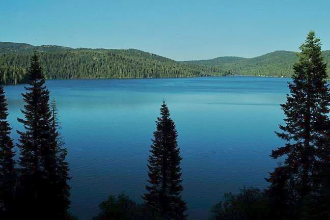
A wide, calm blue lake surrounded by dense evergreen forests and rolling mountain slopes under a clear sky.
Bucks Lake, a reservoir situated within the forested landscape of Plumas National Forest.

Plumas National Forest history and protected-area timeline

Plumas National Forest has roots in the early federal forest conservation movement of the United States. It was first established as the Plumas Forest Reserve by the United States General Land Office on March 27, 1905, at a time when the federal government was actively creating forest reserves to protect watersheds and timber resources in the western states. In 1906, administrative responsibility for the reserve was transferred to the newly expanded United States Forest Service, and on March 4, 1907, the area was formally redesignated as Plumas National Forest.

In 1908, a portion of the Diamond Mountain National Forest was merged into Plumas, expanding its footprint and consolidating management in the northern Sierra Nevada. Throughout the twentieth century, the forest continued to evolve administratively and ecologically, with additional protections layered onto its already established timber and watershed functions. The Bucks Lake Wilderness was officially designated in 1984 as part of the National Wilderness Preservation System, strengthening the forest's conservation profile.

The history of Plumas is also inseparable from the broader story of the Sierra Nevada itself. The region was heavily affected by the California Gold Rush and the subsequent logging economy that supported both mining towns and growing settlements in the Sacramento Valley. Logging has remained an important part of the forest's economy into the modern era, which is reflected in the fact that virtually no virgin, untouched timberland remains. Even so, significant stands of old-growth forest have survived, and these are now recognized as ecologically valuable features that connect Plumas to regional and national conservation efforts.

Plumas National Forest landscape and geographic character

The landscape of Plumas National Forest is defined by the rugged terrain of the northern Sierra Nevada. Elevations rise from foothill zones along the western edge to high mountain ridges and plateaus in the interior, creating a varied topography of canyons, valleys, and ridges. The Feather River and its tributaries cut deep pathways through the forest, giving the terrain a distinctive drainage pattern of steep slopes and narrow valleys.

The forest contains numerous mountain lakes and reservoirs, the most prominent of which is Bucks Lake, situated within the Bucks Lake Wilderness. These water bodies, along with the broader river network, create scenic focal points across the forest and contribute to its reputation as a recreational landscape. The interplay of uplifted bedrock, glacially influenced basins, and deeply incised river canyons gives Plumas a strong sense of topographic relief.

On a broader scale, the forest sits at a notable geographic transition. To the west, the Sierra Nevada slopes descend toward the Central Valley of California, while to the east, the terrain gives way to drier landscapes approaching the Great Basin. Plumas National Forest occupies the meeting point of these regions, and its terrain reflects that overlap, with landforms that feel simultaneously Sierra-like and transitional.

Plumas National Forest ecosystems, habitats, and plant life

The ecological character of Plumas National Forest reflects its position in the northern Sierra Nevada, where coniferous forests dominate across most elevations and exposures. Mixed conifer forests form the core vegetation type, supporting a wide range of tree species that vary with elevation, aspect, and moisture availability. These forests are productive, diverse, and historically significant as both timber resources and habitat for Sierra Nevada wildlife.

Roughly 127,000 acres of Plumas National Forest have been classified as old-growth using an economic-type definition developed by the U.S. Forest Service, representing one of the more substantial old-growth blocks in the Sierra Nevada. The forest's substrate and elevation range support complex patterns of forest succession, with dense understory development in some areas and more open pine-dominated stands in others.

Because the forest spans the transition between the wetter western Sierra and the drier eastern Sierra, it also harbors ecological gradients. Western slopes tend to favor moisture-loving conifers, while eastern exposures support more drought-tolerant species. This gradient contributes to the ecological diversity of Plumas, allowing multiple forest community types to occur in relatively close proximity across the broader landscape.

Plumas National Forest wildlife and species highlights

Plumas National Forest provides important habitat for the suite of wildlife species typical of the northern Sierra Nevada. Its forests support mammals such as black bear, mule deer, and a variety of small mammals, while its rivers, streams, and lakes support trout and other freshwater species. The mix of old-growth and second-growth conifer stands creates structural complexity that benefits species dependent on large trees, snags, and canopy cover.

Birdlife is a significant component of the forest's wildlife profile, with coniferous forests in the Sierra Nevada supporting a rich community of breeding and migratory birds. Raptors, woodpeckers, and songbirds associated with mature conifer habitat are all part of the ecological fabric of Plumas. The forest's lakes and reservoirs further contribute to its bird habitat value, particularly in seasonal migration periods.

The wildlife significance of Plumas is closely tied to its forest structure. Where old-growth conditions have been maintained, the forest offers habitat features that have become rarer in the broader Sierra Nevada, including large diameter trees, downed woody material, and multi-layered canopies. These conditions support species that depend on mature forest environments and reinforce the conservation value of the old-growth stands within the forest.

Plumas National Forest conservation status and protection priorities

Plumas National Forest plays a meaningful role in conservation at both regional and national scales. Its large old-growth blocks have been formally surveyed by the U.S. Forest Service, and the forest has been recognized by the Old-Growth Forest Network for its contribution to the preservation of mature forest ecosystems. This recognition reflects the forest's ecological significance within the Sierra Nevada, where old-growth habitats have been substantially reduced by more than a century of logging.

Beyond old-growth forests, Plumas contributes to conservation through watershed protection. As the principal forested catchment for the Feather River, the forest helps regulate streamflow, sediment delivery, and water quality for downstream communities, agriculture, and hydropower in northern California. This hydrological role gives the forest an importance that extends well beyond its boundaries.

The Bucks Lake Wilderness adds a formal conservation layer to the landscape. Established in 1984, it protects a portion of the forest under the National Wilderness Preservation System, limiting development and ensuring that certain areas remain in a more natural state. Together, these elements (old-growth identification, wilderness designation, watershed function, and federal forest management) define the conservation profile of Plumas National Forest.

Plumas National Forest cultural meaning and human context

The cultural context of Plumas National Forest is shaped by its deep ties to the Feather River and the broader story of the Sierra Nevada frontier. The region was profoundly affected by the California Gold Rush, which brought waves of settlers, miners, and loggers into the northern Sierra. Communities such as Quincy grew along with the forest economy, and the small towns around the forest remain closely connected to its management and recreational use.

The naming of the forest itself reflects this heritage. Its title comes from Rio de las Plumas, the historical name for the Feather River, linking the forest to a long lineage of Spanish and Mexican-era place names in California. Logging has been a defining economic activity throughout the forest's modern history, first as part of the gold-rush timber economy and later as part of the industrial timber industry.

Today, the cultural identity of the Plumas region is tied to outdoor recreation, small mountain communities, and a working forest landscape. The forest is both a place of livelihood for those connected to timber and resource management and a place of recreation for residents of northeastern California and visitors from across the state.

Top sights and standout views in Plumas National Forest

Plumas National Forest stands out for the scale and quality of its old-growth mixed conifer forests, which have been formally mapped by the U.S. Forest Service and recognized by the Old-Growth Forest Network. This makes it one of the most significant old-growth landscapes in the northern Sierra Nevada, even after more than a century of regional timber harvest.

The forest's defining geographic role as the principal watershed of the Feather River gives it importance that extends beyond its boundaries, influencing water resources across northern California. Combined with the designated Bucks Lake Wilderness, the three-district management structure centered on Quincy, and a rich mosaic of mountain lakes, canyons, and forested ridges, Plumas offers a distinctive blend of ecological, hydrological, recreational, and historical significance within the Sierra Nevada.

Best time to visit Plumas National Forest

The character of a visit to Plumas National Forest shifts meaningfully with the seasons. Summer is the most accessible period for exploring the forest's higher elevations, with mountain lakes such as Bucks Lake offering boating, fishing, and shoreline recreation, and the network of roads and trails generally open and dry. Wildflower displays and warmer temperatures make summer a strong choice for hiking and camping.

Spring and early summer bring high water conditions to the Feather River system, swelling rivers and streams with snowmelt and creating dynamic flows that shape the forest's canyons. Autumn brings cooler air, changing light conditions across the forested ridges, and a quieter atmosphere as summer recreation slows. Winter transforms parts of the forest into a snow-covered landscape, supporting winter recreation in selected areas while making higher roads and trailheads more difficult to access. Each season emphasizes a different aspect of Plumas's mountain landscape.

Monthly climate preview

Representative long-term temperature and monthly precipitation averages

Plumas National Forest Climate Normals and Annual Weather Patterns

Plumas National Forest experiences measured monthly temperature swings and varying precipitation rates across its representative coordinate point. Reviewing the complete twelve-month climatology data provides deeper context on long-term weather normals and temperature extremes.
Annual mean8 °C
-1 °C21 °C
Jan-1°
Feb
Mar
Apr
May10°
Jun16°
Jul21°
Aug20°
Sep16°
Oct
Nov
Dec-1°
Warmest month
July

20.9 °C

Coolest month
December

-1.3 °C

Wettest month
December

5.1 mm/day

Driest month
July

0.2 mm/day

Park location guide

Geography guide, regional context, and park location map for Plumas National Forest

Plumas National Forest park geography, regions, and map view in United States of America

Understand where Plumas National Forest sits in United States of America through a broader geographic reading of the surrounding landscape, nearby location context, and its mapped position within the national park landscape.

How Plumas National Forest fits into United States of America

The United States of America is a federal presidential republic and one of the world's largest countries by area and population. It consists of 50 states across a vast territory spanning multiple time zones, with its capital in Washington, D.C. and largest city in New York City. The nation has a diverse economy, influential political system, and significant cultural and military presence globally.

Wider geography shaping Plumas National Forest in United States of America

The United States occupies a vast territory in North America, bordered by Canada to the north and Mexico to the south. The 48 contiguous states stretch from the Atlantic to the Pacific Ocean, while Alaska occupies the northwestern region and Hawaii is an archipelago in the Pacific. The country encompasses diverse terrain including the Rocky Mountains, Appalachian Mountains, Great Plains, and extensive river systems.

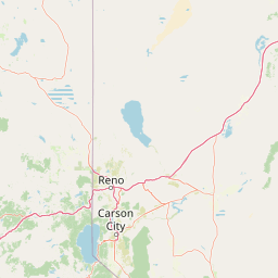
Map view of Plumas National Forest

Use this park location map to pinpoint Plumas National Forest in United States of America, understand its exact geographic position, and read its mapped placement within the surrounding landscape more clearly.

Pigeon | © OpenStreetMap contributors

Location context for Plumas National Forest

California
Recorded earthquake history

Examine the Recorded Earthquake History of Plumas National Forest

Explore the historical catalogue of seismic events associated with Plumas National Forest geography. This MoriAtlas collection provides mapped data and event records to support your review of historical seismic activity within this important Sierra Nevada protected region.

Plumas National Forest Earthquake History

Catalogued events

750 events

Strongest magnitude

Magnitude 5.7

Most recent event

Jun 27, 2026

This history includes earthquakes recorded inside the park or within 50 km of its borders

Explore high-resolution views of old-growth conifer forests, deep canyons, and mountain lake habitats.

Plumas National Forest Photos and Scenery: Visualizing Sierra Nevada Landscapes

Visual documentation captures the rugged topography and forested ridges of Plumas National Forest across northern California. Detailed landscape photography reveals the protected watershed environment and diverse mountain terrain of the Sierra Nevada.

A wide, calm blue lake surrounded by dense evergreen forests and rolling mountain slopes under a clear sky.

Park atlas

Compare regional mountain terrain and connected Sierra Nevada landscapes

Exploring Other Parks and Protected Areas Near Plumas National Forest

Browse nearby national parks and protected areas sharing the rugged terrain and old-growth forests of northern California. Comparing adjacent regional geography reveals broader watershed patterns and transitional mountain habitats across the Sierra Nevada.
A wide watercolor illustration showing a calm body of water surrounded by green hills, conifer trees, and reeds in the foreground.
Protected landscapeCalifornia
Park boundaries overlap#1 closest

Northwest

Lassen National Forest: Mapped Geography and Protected Landscapes of Northern California

Volcanic terrain and expansive old growth ecosystems

Lassen National Forest represents a vast protected landscape in Northern California, defined by its severe volcanic geology and resilient conifer forests. This atlas entry provides essential geographic context regarding the forest boundaries, the volcanic rim of Mount Tehama, and the intricate river systems shaping the region. Explore the terrain, from accessible lava tubes to the wilderness areas preserved within this significant mountain corridor.

Area
4,331.53 km²
Established
1905
Relief
Mountain
Climate
Temperate
Protected landscapeCalifornia
Park boundaries overlap#2 closest

South

Tahoe National Forest: Exploring Protected Mountain Landscapes in the California Sierra Nevada

An atlas of granite river canyons and alpine ridge terrain

Tahoe National Forest defines a critical segment of the western Sierra Nevada, containing granite river canyons, numerous reservoirs, and summits reaching above 9,000 feet. This protected landscape acts as a vital headwater for California foothill communities and Nevada, hosting significant natural features like the Placer County Big Trees Grove and segments of the Pacific Crest Trail.

Area
3,526.82 km²
Established
1899
Relief
Mountain
Climate
Mediterranean
A watercolor painting showing soft green hills, distant pink-hued mountains, and a pale blue lake in a serene, stylized landscape.
Protected landscapeNevada
9.7 km away#3 closest

East

Humboldt, Toiyabe National Forest: Protected Landscape and Regional Mountain Geography

A vast network of Nevada mountain ranges and alpine wilderness

Humboldt, Toiyabe National Forest serves as a defining public land entity across Nevada and eastern California. As the largest national forest in the contiguous United States, it preserves a striking collection of isolated mountain ranges, including the Ruby Mountains and the rugged Jarbidge wilderness, within a broader basin-and-range landscape. Examine the boundaries and terrain that characterize this complex, high-desert ecosystem.

Area
25,454 km²
Established
1908
Relief
Mountain
Access
Easy access
Wildlife reserveCalifornia
20 km away#4 closest

West

Ishi Wilderness Wildlife Reserve: Mapping the Volcanic Canyons of the Cascade Foothills

Geographic atlas of protected northern California wilderness and cultural landscapes.

Ishi Wilderness represents a crucial protected area in northern California, where volcanic geology meets a deep-rooted cultural history. Explore the mapped ridgelines, river canyons, and diverse oak woodland habitats that define this unique wildlife reserve and its role within the Cascade foothills.

Area
167.29 km²
Established
1984
IUCN
Ib
Relief
Mountain
National parkCalifornia
27 km away#5 closest

Northwest

Lassen Volcanic National Park: Protected Landscape Identity and Geographic Context

Discover the mapped boundaries and natural terrain of this California national park.

Gain a structured understanding of Lassen Volcanic National Park as a protected landscape. This detail page provides essential geographic context, focusing on the park's mapped boundaries and its specific terrain characteristics within California. It is designed for users seeking detailed information about the park's protected status and its placement within the broader atlas of natural areas, emphasizing its unique geographic identity and conservation significance.

Area
430.8 km²
Established
1916
IUCN
II
Visitors
504.8K annual
Protected areaNevada
About 55 km away#6 closest

Southeast

Mount Rose Wilderness: Protected Landscape and Regional Geography in Northwestern Nevada

Carson Range alpine terrain and ecological transition mapping

Mount Rose Wilderness represents a significant protected area in the Carson Range, where 31,223 acres of terrain transition from the forested, subalpine slopes of the Sierra Nevada to the drier, sage-dominated Great Basin. The mapped landscape includes high granite peaks and meadows, offering a clear view of the complex environmental gradients that define this unique section of the American West.

Area
126.35 km²
Established
1989
Relief
Mountain
Climate
Temperate
Protected landscapeCalifornia
65 km away#7 closest

North

Modoc National Forest: Protected Landscape and Warner Mountains Geography

High desert volcanic terrain in northeastern California

Modoc National Forest encompasses a massive expanse of volcanic plateaus and rugged mountain ridges in the northeastern corner of California. This protected area offers significant geographic variety, transitioning from arid sagebrush basins to lush, high-elevation conifer forests. It serves as a vital natural landscape, home to the South Warner Wilderness and large stands of old-growth timber, reflecting the unique geologic history of the regional lava flows.

Area
6,695.09 km²
Established
1904
Relief
Mountain
Access
Moderate access
A watercolor illustration showing a soft, panoramic view of green trees and rolling hills against pale, pinkish-yellow mountains in the background.
Protected landscapeCalifornia
84 km away#8 closest

West

Mendocino National Forest: Mapping California's Remote Protected Mountain Landscape

Examining wilderness boundaries and rugged coastal terrain

Mendocino National Forest serves as a significant protected area in California, known for being the only national forest in the state without major paved access. Its terrain spans 913,000 acres of mountain peaks, deep river canyons, and old-growth conifer forests. Home to the unique tule elk population at Lake Pillsbury, this landscape provides a rare example of wilderness isolation, complex geothermal features, and rugged, largely untouched northern coastal topography.

Area
3,696.02 km²
Established
1907
Relief
Mountain
Climate
Mediterranean

Common questions about visiting, size, designation, and location context for Plumas National Forest

Plumas National Forest FAQs for park facts, access, geography, and protected area context

Find quick answers about Plumas National Forest, including protected-area facts, park geography, trail and visitor context, and how the park fits into its surrounding country and regional landscape.
MoriAtlas Explorer

Continue Your Protected Areas Search Across the Global Atlas

Deepen your exploration by continuing the structured search for national parks and protected areas worldwide. Utilize the comprehensive filtering capabilities to compare different conservation landscapes and refine your understanding of global park geography. Discover more about the distribution and characteristics of protected natural areas.

Global natural geography