Mori Atlas logo
Wildlife reservePolokwane Game Reserve

A study of bushveld terrain, riverine waterholes, and seasonal flora in Limpopo province

Polokwane Game Reserve: Analyzing the Geographic Landscape and Protected Area Boundaries

Polokwane Game Reserve represents a significant municipal protected area in South Africa, spanning roughly 2,800 hectares of diverse bushveld terrain. The landscape features a distinct eastern ridge defined by dense stands of Aloe marlothii and expansive grassy plains intersected by a tributary of the Sand River. This analysis examines the reserve's internal geography, its role as a green enclave near the city of Polokwane, and the physical characteristics that shape its wildlife habitats.

bushveldmunicipal game reservesouth africalimpopopolokwanegrassy plains

Polokwane Game Reserve

Wildlife reserve

Park overview

Structured park overview, official facts, and landscape profile for Polokwane Game Reserve

Polokwane Game Reserve park facts, protected area profile, and essential visitor context

Review the core facts for Polokwane Game Reserve, including designation, size, terrain, visitor scale, habitats, and operating context in one park-focused overview.

About Polokwane Game Reserve

Polokwane Game Reserve is a sizable protected area on the southern outskirts of Polokwane, the capital city of Limpopo province in northeastern South Africa. Its entrance lies near the reserve's northern boundary, only about one kilometer south of the busy N1 freeway, and is reached via Silicon Street. Despite this proximity to a major transport corridor and urban areas, the reserve functions as a working game reserve where grassy plains, scattered bushveld thickets, and more densely vegetated ridges combine to create a recognisable African bushveld experience within a municipal context.

The reserve covers around 2,800 hectares, a scale that places it among the largest game reserves under municipal control in South Africa. Rather than being a remote wilderness, it serves as an accessible green space where visitors can experience a slice of the province's natural character without long-distance travel. This makes it both a tourism asset for the city and a meaningful conservation area for the surrounding region.

In ecological terms, the reserve protects a representative slice of the Limpopo bushveld. Open plains dominate much of the area, broken by clumps of woody vegetation including acacia and Searsia species. The eastern section rises into a ridge that supports thick stands of Aloe marlothii, large succulents whose winter flowers transform that part of the landscape into a notable seasonal sight. A small tributary of the Sand River meanders through the property and has been dammed at several points to ensure a reliable water supply for resident wildlife across the drier months.

The reserve's combination of urban accessibility, substantial size, and relatively diverse habitats has made it an important element of Polokwane's recreational and conservation infrastructure. It provides habitat for a range of game animals and an increasingly significant bird population, while also giving visitors a convenient introduction to the broader bushveld environments that characterise much of Limpopo province beyond the city limits.

Quick facts and research context for Polokwane Game Reserve

Polokwane Game Reserve lies in Limpopo province in northeastern South Africa, a short distance south of the N1 freeway on the outskirts of the city of Polokwane, the provincial capital. Established in 1977, it occupies around 2,800 hectares and is considered one of South Africa's largest municipal game reserves. Its terrain combines open grassy plains, scattered bushveld thickets, and a more wooded and aloe-rich eastern ridge, while a small tributary of the Sand River has been dammed within the reserve to support its animal populations. Because of its scale and proximity to a major city, it stands out as a noteworthy example of a municipally managed game reserve in the region.

Protection and recognition

Examine documented terrestrial conservation parameters and management scope

Polokwane Game Reserve Protection Status and Territorial Designation Facts

Polokwane Game Reserve maintains a documented terrestrial protection status within the regional conservation framework. Systematic administrative records outline the established designation boundaries and operational management parameters without external recognition sources.

Protection details

Protection scope
Terrestrial
Transboundary protection
No
Park context

Deeper park guide and search-rich context for Polokwane Game Reserve

Polokwane Game Reserve history, landscape, wildlife, and travel context

Explore Polokwane Game Reserve through its history, landscape character, ecosystems, wildlife, conservation priorities, cultural context, and seasonal travel timing in a structured park guide built for atlas discovery and search intent.

Why Polokwane Game Reserve stands out

The reserve is best known for its unusual size for a municipal game reserve in South Africa and for its setting right on the edge of Polokwane, allowing visitors to move quickly from urban surroundings into a recognizably bushveld landscape. The seasonal flowering stands of Aloe marlothii on the eastern ridge are a particular highlight, turning that part of the reserve into a vivid winter feature, while the dammed sections of a Sand River tributary create waterholes that concentrate game and birdlife. It is also recognized as an accessible wildlife destination within Limpopo itself, offering visitors a chance to see bushveld species and large gatherings of birds such as marabou storks without having to travel into more remote national parks. This blend of proximity, scale, and seasonal character has shaped its reputation as a distinctive urban-edge reserve.
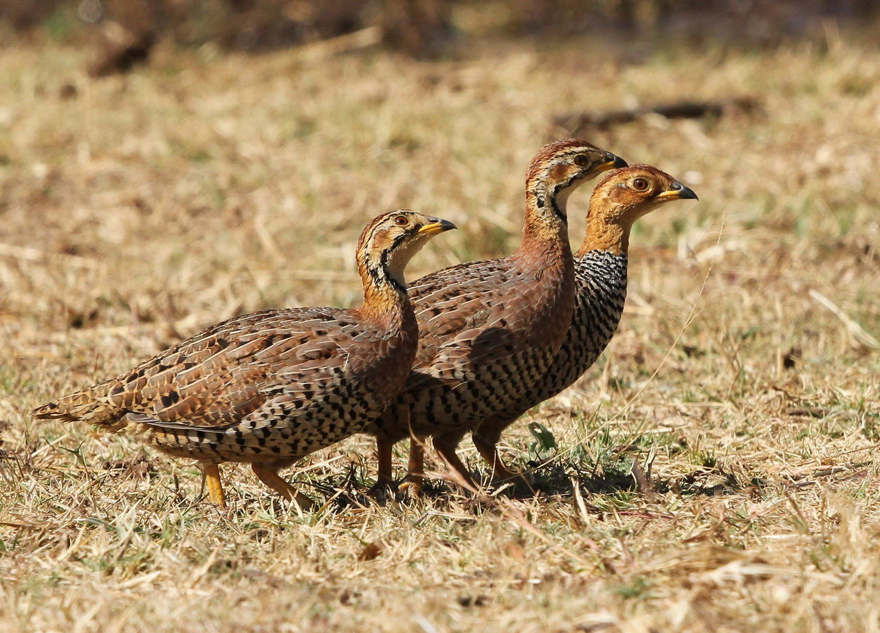
Three small brownish game birds known as Coqui francolins standing in a line on dry, yellowed grass.
Three Coqui francolins moving through the dry grasslands of the Polokwane Game Reserve.

Polokwane Game Reserve history and protected-area timeline

Polokwane Game Reserve was established in 1977 as Pietersburg Nature Reserve, taking its original name from the city of Pietersburg, which was later renamed Polokwane. From the outset, it was conceived as a municipally managed conservation area on the edge of the city, rather than as a remote national park, and it has retained that municipal character throughout its history.

Over time, the reserve's role has evolved alongside the city around it. As Polokwane grew into the administrative and economic center of Limpopo province, the reserve took on added importance as a large green buffer and a place where residents and visitors could experience bushveld scenery and wildlife close to the urban core. Its earlier name continues to surface in some references, and the renaming reflects broader post-apartheid changes to place names in the region rather than a change in the reserve's institutional function.

The continued operation of the reserve, including the maintenance of its dammed water sources and managed habitat areas, indicates an ongoing municipal commitment to keeping this 2,800-hectare area functioning as a game reserve despite its location near the N1 freeway and the expanding city of Polokwane.

Polokwane Game Reserve landscape and geographic character

The landscape of Polokwane Game Reserve is a clear expression of typical Limpopo bushveld, dominated by open grassy plains that stretch across much of the reserve. These plains are dotted with clumps and thickets of woody vegetation, including acacia and Searsia species, breaking up the expansive grassland with patches of denser bush that provide cover for game and add visual variety to the terrain.

In the eastern portion of the reserve, the topography rises into a ridge that supports a much denser vegetation cover. This part of the reserve is particularly notable for its stands of Aloe marlothii, a large and structurally imposing succulent. In winter, when these aloes come into flower, the ridge becomes one of the most visually distinctive features of the landscape, with bright inflorescences rising above the surrounding vegetation.

A small tributary of the Sand River runs through the reserve, and its flow has been managed through a series of small dams at various points along the watercourse. These dams create a chain of waterholes that are a defining physical feature of the reserve, especially in dry seasons, and they shape how animals distribute themselves across the property.

Polokwane Game Reserve ecosystems, habitats, and plant life

The reserve's natural character reflects the broader ecological profile of the Limpopo bushveld, with grassy plains, scattered woody vegetation, and a more distinctive ridge habitat in the east. The combination of open grassland and bush clumps supports mixed-use habitat, where grazing animals can find forage in the open areas while browsers and smaller species make use of the denser thickets for shelter.

The dammed sections of the Sand River tributary add a strong water-focused element to the reserve's ecology. By holding water even through dry periods, these dams sustain a permanent concentration of animal activity and influence the distribution of both large mammals and birds across the reserve. The resulting vegetation patterns around the waterholes further diversify the habitat mosaic.

Seasonality plays an important role in the reserve's natural rhythms. The winter flowering of the Aloe marlothii stands on the eastern ridge periodically transforms a small part of the reserve into a particularly colorful landscape feature, while the wet and dry cycles of the broader region shape the quality of grazing, water availability, and animal concentrations. These dynamics give the reserve a sense of seasonal change despite its relatively modest size.

Polokwane Game Reserve wildlife and species highlights

The reserve supports a community of bushveld game typical of its region, sustained in part by the chain of dams created along the Sand River tributary that passes through the property. These water sources draw animals across the landscape and tend to concentrate activity around particular points within the reserve, a pattern that is useful both for wildlife viewing and for the animals' own survival during drier conditions.

Birdlife is a significant component of the reserve's wildlife profile. The reserve is home to species such as coqui francolins, observed in coveys within the property's mixed bush and grassland habitats. Bird numbers can be substantial, and as of the mid-2020s, roosting flocks of roughly 1,000 marabou storks had been recorded in the reserve, reflecting its capacity to support large seasonal or temporary gatherings of birds alongside its more resident wildlife.

The mix of plains, bush clumps, ridge vegetation, and waterholes creates a setting in which both mammals and birds can find suitable habitat relatively close to one of Limpopo's main urban centers. While the reserve does not present itself as a remote big-game wilderness, its ecological mosaic allows it to host a meaningful and visible wildlife presence within its municipal borders.

Polokwane Game Reserve conservation status and protection priorities

Polokwane Game Reserve plays a notable conservation role as one of the largest municipally managed game reserves in South Africa. Its scale, combined with its protected status, means that a substantial area of bushveld habitat has been maintained in a region where urban expansion and development pressures are strong. The reserve effectively functions as a green buffer around part of Polokwane and as a refuge for the wildlife and plant communities that would otherwise be increasingly compressed by city growth.

The reserve's conservation approach centers on maintaining usable habitat for game animals, including the deliberate damming of a Sand River tributary to ensure year-round water availability. This kind of water resource management is particularly significant in a semi-arid environment where natural water sources can fluctuate seasonally, and it underlines the practical management effort that underpins the reserve's continued value for wildlife.

In a broader South African context, the reserve demonstrates how municipal authorities can sustain meaningful protected areas adjacent to large cities. By preserving its mix of open plains, bush thickets, and the aloe-covered eastern ridge, the reserve safeguards a representative slice of Limpopo's bushveld character and offers a working example of urban-adjacent conservation in the province.

Polokwane Game Reserve cultural meaning and human context

The reserve's identity is closely tied to the city of Polokwane, which serves as the capital of Limpopo province and the urban center from which the reserve takes its name. The earlier name, Pietersburg Nature Reserve, reflects an older place-name identity linked to the same city before it was renamed Polokwane, and the continuity of those names indicates how strongly the reserve is associated with its host city's identity and history.

Because the reserve sits so close to the N1 freeway and the city itself, it is woven into everyday local life in a way that more remote parks are not. Visitors, residents, and passing travelers can quickly move between an urban environment and a recognisably bushveld landscape, giving the reserve a particular role as a place where the natural and built environments of Limpopo converge.

Top sights and standout views in Polokwane Game Reserve

Among the reserve's most distinctive highlights is the eastern ridge, where dense stands of Aloe marlothii put on a striking flowering display in winter, transforming a portion of the reserve into a vivid seasonal feature. The reserve's chain of dams along a tributary of the Sand River is another defining element, providing consistent water sources that shape where wildlife gathers within the property.

The reserve's scale also stands out. At roughly 2,800 hectares, it ranks among the largest municipal game reserves in South Africa, offering a sense of open space that many urban-edge reserves cannot match. Together with its proximity to Polokwane and the N1 freeway, this combination of size, accessibility, distinctive habitat, and seasonal aloe blooms gives the reserve a strong and recognizable identity within Limpopo.

Best time to visit Polokwane Game Reserve

Because the reserve sits within a region with distinct wet and dry seasons, the time of year meaningfully affects the visitor experience. The winter months bring cooler, drier conditions and the flowering of the Aloe marlothii stands on the eastern ridge, making that part of the reserve especially striking for visitors interested in scenery and photography.

Drier periods also tend to concentrate animals around the reserve's dammed water sources, which can make game viewing more rewarding as wildlife becomes more dependent on the chain of waterholes along the Sand River tributary. By contrast, wetter periods generally bring lusher grass, denser vegetation overall, and more dispersed wildlife activity, while reducing dependence on artificial water sources. Visitors interested in birdlife may also find seasonal variation meaningful, given that the reserve has supported very large gatherings of species such as marabou storks in some years.
Monthly climate preview

Long term representative measurements tracking monthly temperature and precipitation variation across the protected landscape.

Polokwane Game Reserve Climate Normals and Annual Temperature Rhythm

Historical records from 1991 through 2020 document the measured annual temperature and precipitation rhythm across representative terrain at an elevation of 1,319 meters. Detailed monthly comparisons provide complete statistical depth regarding average minimums, maximums, and daily precipitation patterns.
Annual mean18 °C
12 °C22 °C
Jan22°
Feb22°
Mar21°
Apr18°
May15°
Jun12°
Jul12°
Aug15°
Sep19°
Oct21°
Nov22°
Dec22°
Warmest month
December

22.3 °C

Coolest month
July

12 °C

Wettest month
January

3.2 mm/day

Driest month
August

0.1 mm/day

Park location guide

Geography guide, regional context, and park location map for Polokwane Game Reserve

Polokwane Game Reserve park geography, regions, and map view in South Africa

Understand where Polokwane Game Reserve sits in South Africa through a broader geographic reading of the surrounding landscape, nearby location context, and its mapped position within the national park landscape.

How Polokwane Game Reserve fits into South Africa

South Africa is the southernmost country in Africa, spanning 1.22 million km² with a population of over 63 million. The country operates with three capital cities, Pretoria (executive), Cape Town (legislative), and Bloemfontein (judicial), and is renowned for its biodiversity, national parks, and multicultural society.

Wider geography shaping Polokwane Game Reserve in South Africa

South Africa occupies the southernmost region of Africa, with coastline along both the Atlantic Ocean to the west and the Indian Ocean to the east. The interior features elevated plateaus including the Highveld, with the Drakensberg escarpment marking the eastern highlands. The country shares borders with Namibia, Botswana, Zimbabwe, Mozambique, Eswatini, and Lesotho.

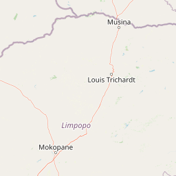
Map view of Polokwane Game Reserve

Use this park location map to pinpoint Polokwane Game Reserve in South Africa, understand its exact geographic position, and read its mapped placement within the surrounding landscape more clearly.

Pigeon | © OpenStreetMap contributors

Location context for Polokwane Game Reserve

Limpopo

Visualizing bushveld terrain, rocky ridges, and protected wildlife habitats in Limpopo

Polokwane Game Reserve Photos and Landscape Scenery

Visual records illustrate the open grassy plains, riverine waterholes, and rocky ridges that define the terrain across Polokwane Game Reserve. Photographic documentation reveals the distinct bushveld character and seasonal vegetation patterns found throughout the protected area.

Three small brownish game birds known as Coqui francolins standing in a line on dry, yellowed grass.

Park atlas

Compare adjacent bushveld habitats and regional conservation landscapes

Explore Parks Near Polokwane Game Reserve and Surrounding Protected Areas

Browsing other protected areas near Polokwane Game Reserve reveals a wider network of bushveld habitats and regional wildlife reserves. Expanding the geographic comparison provides deeper insight into the natural terrain and conservation character of the surrounding region.
Protected areaLimpopo
About 65 km away#1 closest

East

Wolkberg Wilderness Area: Protected Mountain Geography and Quartzite Ridge Landscapes

Mapping the diverse Afromontane ecosystems of the Limpopo escarpment

Wolkberg Wilderness Area protects a high-altitude transition zone in South Africa, where quartzite massifs rise sharply above the surrounding plains. This reserve features a rugged, low-infrastructure environment defined by mist-influenced forests, clean mountain rivers, and steep boulder slopes. Analyze the geographic boundaries and terrain features that make this reserve a critical sanctuary for regional bird species and forest-loving plant communities.

Area
220 km²
Established
1977
Relief
Mountain
Climate
Subtropical
Biosphere reserveLimpopo
About 81 km away#2 closest

West

Waterberg Biosphere: A Protected Sandstone Massif in Limpopo Province South Africa

Geology, mapping, and ecological zones of the Waterberg range

The Waterberg Biosphere stands as a major protected region in South Africa, formed by ancient sandstone layers sculpted into mesas and deep gorges. This massif bridges ecological zones from highland savanna to riverine habitats, anchoring a network of game reserves and wilderness areas through its distinctive geological and historical landscape identity.

Area
6,540.33 km²
Established
2001
Relief
Mountain
Climate
Subtropical
Nature reserveLimpopo Province
About 105 km away#3 closest

Southwest

Nylsvley Nature Reserve: A Geographical Overview of Limpopo Province's Wetland Landscapes

Protected floodplain ecosystems and seasonal riverine terrain

Nylsvley Nature Reserve protects a vast, shallow floodplain and surrounding open woodland, creating a high-density conservation zone in the Limpopo Province. Its terrain is defined by the seasonal interaction of the Nyl River, extensive reedbeds, and unique botanical communities. This profile examines the reserve as a significant reference point for understanding the interplay between floodplain geography, savanna bushveld, and inland wetland habitats.

Area
40 km²
Established
1998
Relief
Lowland
Access
Access unknown
Nature reserveLimpopo Province
About 112 km away#4 closest

North

Blouberg Nature Reserve: Geographic Map and Protected Landscape Overview in Limpopo, South Africa

Tracing the savanna and mountain transition zones of a northern protected area

Blouberg Nature Reserve offers a distinctive look at the Limpopo landscape, encompassing steep sandstone cliffs, old-growth mountain forest patches, and open baobab-studded plains. This protected area stands as a focal point for understanding the ecological transition between the Soutpansberg range and the Limpopo lowveld. Use this atlas resource to understand the park's internal topography, its specific habitat boundaries, and its regional position as a significant node for raptor conservation in southern Africa.

Area
93.6 km²
Established
1990
Relief
Mountain
Climate
Subtropical
A soft watercolor painting of a river flowing through a hilly, green valley with distant ridgelines under a pale sky.
Nature reserveLimpopo
About 113 km away#5 closest

West

Lapalala Wilderness Nature Reserve: Geographic Atlas and Park Landscape Mapping

Protected bushveld terrain in the Limpopo province of South Africa

Lapalala Wilderness represents an influential private conservation landscape featuring over forty-eight thousand hectares of bushveld habitat. Gain insight into the reserve's structural diversity, including its sixty kilometers of priority river systems and distinct land types that define this protected territory in Limpopo.

Area
480 km²
Established
1981
Relief
Upland
Climate
Subtropical
A horizontal watercolor painting depicting the Blyde River Canyon with green slopes, reddish cliff faces, and a winding river.
Nature reserveMpumalanga
About 155 km away#6 closest

Southeast

Blyde River Canyon Nature Reserve: Escarpment Geography and Protected Landscape Map

Mapping river-carved canyons and plateau ecosystems in Mpumalanga

Blyde River Canyon Nature Reserve protects a vast stretch of the Mpumalanga Drakensberg, characterized by vertical cliffs, rocky massifs, and deep river gorges. This atlas-focused resource highlights the reserve's geological landmarks, including the Three Rondavels and Bourke's Luck Potholes, offering a clear view of the complex terrain and protected natural boundaries defining this northeastern South African landscape.

Area
290 km²
Established
1965
Relief
Mountain
Climate
Subtropical
Nature reserveLimpopo
About 156 km away#7 closest

East

Balule Nature Reserve: Mapping the Protected Lowveld Savannah and Olifants River Corridor

An open-system wilderness integral to the Greater Kruger ecological network.

Explore the geographic identity of Balule Nature Reserve, a vast protected area in South Africa characterized by its integration with the Greater Kruger wilderness. The terrain encompasses a rich mix of mopane-dominated woodland, riverine forest along the Olifants River, and open subtropical bushveld that supports significant wildlife migrations.

Area
400 km²
Relief
Lowland
Climate
Subtropical
Access
Moderate access
Nature reserveMpumalanga
About 156 km away#8 closest

Southeast

Verloren Valei Nature Reserve: Highveld Grassland and Wetland Protected Area Geography

Steenkampsberg plateau landscape in Mpumalanga, South Africa.

Verloren Valei Nature Reserve protects a remarkable high-altitude highland plateau ecosystem near Dullstroom. Featuring rolling grasslands and a complex network of wetlands, this region provides a critical refuge for rare bird species, indigenous flora, and distinct plateau biodiversity across a diverse mosaic of rocky ridges and marshy terrain.

Area
58.91 km²
Relief
Upland
Access
Access unknown
Scope
Terrestrial

Common questions about visiting, size, designation, and location context for Polokwane Game Reserve

Polokwane Game Reserve FAQs for park facts, access, geography, and protected area context

Find quick answers about Polokwane Game Reserve, including protected-area facts, park geography, trail and visitor context, and how the park fits into its surrounding country and regional landscape.
MoriAtlas Explorer

Continue Your Protected Areas Search Across the Global Atlas

Deepen your exploration by continuing the structured search for national parks and protected areas worldwide. Utilize the comprehensive filtering capabilities to compare different conservation landscapes and refine your understanding of global park geography. Discover more about the distribution and characteristics of protected natural areas.

Global natural geography