
Mori Atlas logo
Nature reservePrachovské skály

A geologic study of eroded sandstone formations in the heart of the Bohemian Paradise

Prachovské skály Nature Reserve: Mapped Sandstone Towers and Protected Landscape Geography

Prachovské skály presents a dense network of Cretaceous-era sandstone pinnacles, narrow fissures, and deep gorges located within the Královéhradecký kraj region of the Czech Republic. As a long-standing nature reserve, this protected area features a unique geomorphology where dramatic towers rise abruptly from forested terrain. Our atlas documentation traces the boundaries and landscape features of this central European rock city, providing a detailed perspective on its formation and its role within the wider Český ráj countryside.

sandstone rocksrock cityprotected landscapenature reserveBohemian Paradisesandstone formations
A stylized digital illustration of vertical sandstone rock formations rising through a dense forest, framed by pine branches in the foreground under a pale blue sky.

Prachovské skály

Nature reserve

Park overview

Structured park overview, official facts, and landscape profile for Prachov Rocks

Prachov Rocks park facts, protected area profile, and essential visitor context

Review the core facts for Prachov Rocks, including designation, size, terrain, visitor scale, habitats, and operating context in one park-focused overview.

About Prachov Rocks

Prachov Rocks is one of the signature natural landmarks of the Bohemian Paradise, a protected landscape area in northern Bohemia that the rocks have helped to define in the popular imagination. Located a few kilometers northwest of Jičín, the reserve encompasses an extensive clustered field of sandstone outcrops rising out of mixed forest and farmland. The rocks are not a single isolated cliff line or canyon: they form a maze-like complex of towers, fissures, saddle-shaped ridges, and small plateaus, threaded by walking paths and overlook platforms.

The defining identity of Prachov Rocks rests on its combination of geology, ecology, and recreational value. The Cretaceous sandstone has weathered into rounded, often photogenic forms that distinguish the site from the more sharply eroded rock towns found elsewhere in the Czech Republic. Tourist infrastructure in the form of three marked circuits, viewing platforms with names drawn from long local tradition, and a network of climbing routes means the reserve functions as both a natural monument and an outdoor recreation hub. Its scale, accessibility from Jičín and Prague, and compactness make it a frequent point of entry for visitors exploring the broader Český ráj region.

The site also carries a layered human story. Archaeological evidence indicates prehistoric habitation, and the rocks served as a natural stronghold for early Slavic communities in the area. Later medieval and early modern landowning families shaped the surrounding villages and estates, while the wider region was caught up in the upheavals of the Thirty Years' War era and the later conflicts of the nineteenth century. The combination of dramatic geology and accumulated cultural depth gives Prachov Rocks a place of enduring regional significance within Bohemian natural heritage.

Quick facts and research context for Prachov Rocks

Prachov Rocks is a nature reserve in the Královéhradecký Region of the Czech Republic, northwest of Jičín, and part of the broader Český ráj Protected Landscape Area. The protected zone covers roughly 262 hectares across the cadastral territories of Holín and Zámostí, with elevations ranging from about 300 to 462 meters above sea level. The formation is built from Cretaceous sandstone, shaped over geological time into towers, gorges, and platforms.

The area has been officially protected since 1933 and is managed by the Czech Agency for Nature Conservation and Landscape Protection. Three marked tourist circuits, several named viewpoints, and a developed climbing tradition make it a major outdoor destination. The site has prehistoric-to-medieval archaeological layers and is associated with one of the battles of the Austro-Prussian War of 1866.

Protection and recognition

Documented terrestrial protection scope, designation year, and management framework

Prachovské Skály Protection Status And Designation History

Prachovské skály maintains documented terrestrial protection status established in nineteen thirty-three across its landscape. Historical designation records outline the official conservation framework governing this notable protected area.

Protection details

Protection scope
Terrestrial
Designated year
1933
Transboundary protection
No
Park context

Deeper park guide and search-rich context for Prachov Rocks

Prachov Rocks history, landscape, wildlife, and travel context

Explore Prachov Rocks through its history, landscape character, ecosystems, wildlife, conservation priorities, cultural context, and seasonal travel timing in a structured park guide built for atlas discovery and search intent.

Why Prachov Rocks stands out

Prachov Rocks is renowned for its dense sandstone rock city of pinnacles, towers, and narrow chasms carved out of Cretaceous-era sediments. The site's defining appeal is the contrast between forested lowlands and the sudden, dramatic outcrops of sculpted sandstone just a short walk from the trailheads. The reserve is also known as a historic rock climbing area within Bohemia, where established routes and friendly sandstone surfaces have drawn climbers since the late nineteenth century. Combined with panoramic viewpoints, marked walking circuits, and a long record of tourism and cultural references, it has become one of the most iconic natural visitor destinations in the Bohemian Paradise.
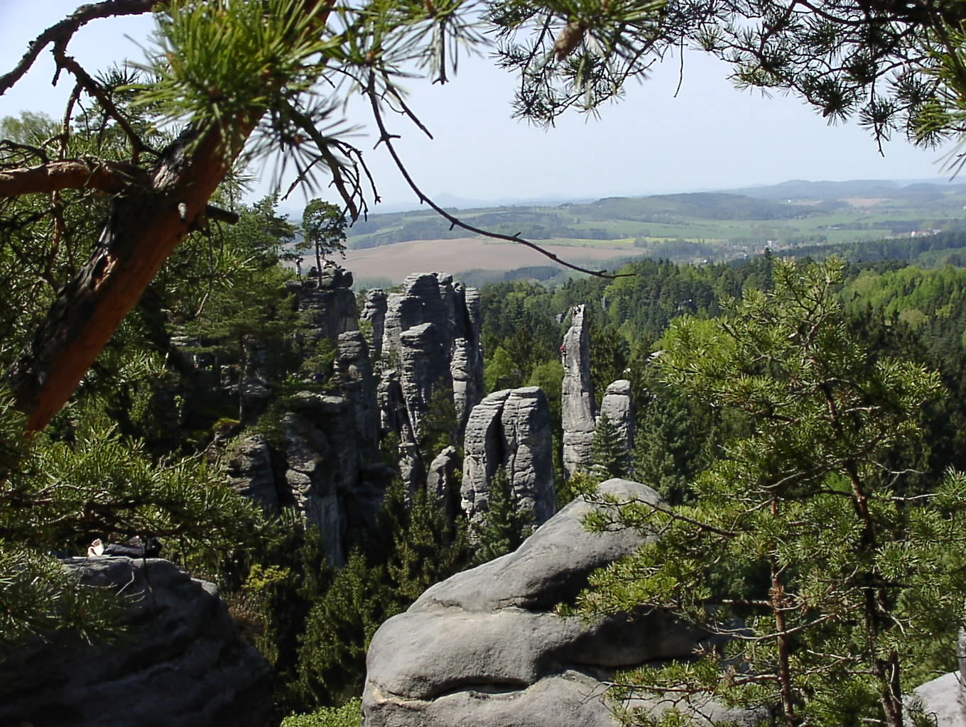
Looking through pine tree branches at a valley filled with vertical sandstone rock towers in Prachovské skály.
A scenic overlook of the sandstone rock formations in Prachovské skály.

Prachov Rocks history and protected-area timeline

The Prachov Rocks area shows evidence of human presence extending back to prehistoric times, with archaeological finds documenting activity from the Stone Age onward. The natural defensive qualities of the rock labyrinth made it attractive to early Slavic communities, who used the formations as a refuge and established the first settlements within them, reinforced at only a few points by defensive ramparts.

In the late thirteenth century, the nearby basalt hilltop of Veliš became the seat of the Veliš estate, which over the following centuries passed through the hands of several noble families including the Vartenberks and the Trčkas of Lípa. At the beginning of the seventeenth century the Smiřický family took over the estate, but in 1625 the Waldsteins acquired the territory and incorporated it into their Frýdlant Duchy. Disruption during the wider wars of the period led to the eventual decline of the small settlements inside the rocks themselves.

A new phase of development began in 1637 when Colonel Jindřich Šlik, of the noble Šlik family, acquired the estate. The Šlik family retained ownership of the wider domain until 1948, when post-war nationalization removed them from the property. In 1866 one of the engagements of the Austro-Prussian War took place in the immediate vicinity of the rocks, a conflict in which the smaller Prussian force was victorious.

From the late nineteenth century onward, the rocks attracted climbers and tourists. The complex was first documented in detail in 1874 by the Jičín gymnasium professor Antonín Zefyrin Maloch, whose students completed and published a more complete map in 1879. The area was designated a state nature reserve in 1933, and after 1989 and the political changes that followed, the Šlik family regained the property through restitution in 1996, beginning tourism-related operations at the site from 2000.

Prachov Rocks landscape and geographic character

The landscape of Prachov Rocks is defined by a compact, deeply weathered sandstone massif that rises sharply out of an otherwise gentle northern Bohemian countryside. The rocks themselves are exposed remnants of Cretaceous sea-floor sediments: thick layers of sandstone laid down when this part of central Europe lay under a shallow epicontinental sea. Over geological time, erosion by water, frost, and wind has sculpted the original continuous rock into towers, blocks, clefts, and narrow gorges, producing the kind of rounded, varied forms often described as a rock city or rock town.

In geomorphological terms, the rocks belong to the broader Jičín Highlands, within the Turnovská pahorkatina subunit and the more specific Vyskeřská vrchovina and Prachovská pahorkatina classifications. Elevations within the protected area range roughly between 300 and 462 meters above sea level, so visitors experience a combination of low forested terrain, occasional plateaus, and pinnacles that lift the eye well above the surrounding agricultural landscape.

The reserve sits amid a broader mosaic of farmland, woodland, and dispersed villages, with hamlets such as Prachov, Pařezská Lhota, Horní Lochov, and Zámostí marking the cultural edge of the formation. From selected viewpoints along the marked circuits, the rocks frame wide vistas over the Český ráj countryside, while inside, the trails weave between cliffs and beneath overhangs, where the interplay of light, mossy walls, and narrow defiles produces the intimate atmosphere that has long defined the visitor experience.

Prachov Rocks ecosystems, habitats, and plant life

Ecologically, Prachov Rocks functions as a protected enclave of sandstone-cliff habitats, mixed woodlands, and small sub-inland cliff communities within an otherwise heavily cultivated part of Bohemia. The reserve protects a relatively compact area, but the diversity of microhabitats is unusually high for an inland setting: sandstone outcrops, sheltered fissures, ledges, scree, and a mosaic of forest patches on and around the rocks create a layered habitat structure.

Vegetation patterns reflect both the substrate and the human history of use. Open rock faces support specialized communities adapted to thin soils, periodic drought, and temperature extremes, while the gentler slopes and surrounding ground carry woodland made up of broadleaf species typical of central European lowland and hill forests. The combination of cliff, woodland, and edge habitats gives the reserve value for species that depend on this kind of habitat mosaic, and it forms one of the building blocks of the broader Český ráj Protected Landscape Area, which it directly adjoins.

Prachov Rocks wildlife and species highlights

Wildlife at Prachov Rocks is closely tied to the structural diversity created by the sandstone outcrops and the surrounding forest. Cliff faces, crevices, ledges, and the quiet rocky interiors provide habitat structures that contrast with the open farmland around the rocks. The site supports typical central European forest and cliff-edge fauna, with birdlife and small mammals particularly associated with the wooded and rocky parts of the reserve.

The wider Bohemian Paradise landscape, of which the reserve is a part, is known for its mix of woodland, meadow, and rock habitat, supporting a range of woodland bird species and small carnivores. Within Prachov Rocks specifically, the most notable wildlife dimension is the way the rock formations provide refuge, nesting, and shelter opportunities that are rare in the surrounding agricultural landscape.

Prachov Rocks conservation status and protection priorities

Prachov Rocks has been a designated nature reserve since 1933, making it one of the older formal protected-area designations in the region. Today it is administered by the Czech Agency for Nature Conservation and Landscape Protection, with management focused on preserving the geological structures, the habitat diversity, and the associated cliff and forest communities while accommodating public use.

The site's broader conservation significance comes from its role within the Český ráj Protected Landscape Area, where it functions as a key natural landmark and one of the most strictly protected sandstone rock formations in the system. Public access is channeled through three designated walking circuits, and climbing is regulated through seasonal timing and recognized-club membership rules. These access arrangements reflect a deliberate balance between maintaining the integrity of the rock habitats and allowing the long-established traditions of tourism and sport climbing that have developed around the site since the late nineteenth century.

Prachov Rocks cultural meaning and human context

The cultural context of Prachov Rocks extends from prehistoric habitation through medieval landholding and into modern Bohemian popular culture. Archaeological finds indicate that humans lived among or near the rocks as early as the Stone Age, and the formations later served as a natural Slavic refuge and settlement zone. Successive noble families, including the Vartemberks, the Trčkas of Lípy, the Smiřickýs, the Waldsteins, and the Šlik family, shaped the surrounding estates and villages over several centuries.

A notable historical episode is the Austro-Prussian War engagement of 1866, which was fought in the immediate vicinity of the rocks. In the twentieth century, the Šlik family, who had held the wider estate since 1637, lost ownership through nationalization in 1948 and regained it through post-1989 restitution proceedings in 1996, after which tourism services were restarted at the property. In Czech popular culture, the rocks gained broader recognition through a song of the same name by Ivan Mládek, embedding the site in national cultural memory.

Top sights and standout views in Prachov Rocks

Prachov Rocks is most distinctive for the dense, walk-through sandstone rock city that defines its interior, where narrow paths pass between towers, fissures, and overlook platforms. The setting within the Český ráj Protected Landscape Area links the site to one of the most recognizable scenic landscapes in the Czech Republic, and the place on which much of that region's identity is built.

Other notable features include the longstanding climbing tradition that began in the late nineteenth century, the stone fortress ruins that hint at the medieval defensive use of the rocks, and the strong visitor infrastructure of three marked circuits and named viewpoints. Combined with the documented prehistoric and medieval layers of human activity, this gives the reserve a layered combination of geological, ecological, and cultural value.

Best time to visit Prachov Rocks

Prachov Rocks is a year-round destination, but the experience changes meaningfully with the seasons. Spring brings fresh vegetation and active birdlife, while summer offers the fullest atmospheric immersion in the rock labyrinth, with shaded corridors and warm sandstone walls. Autumn produces strong color contrasts between the orange-hued forest and the pale rock towers, often considered one of the most photogenic periods.

Winter visits have their own appeal: lower visitor numbers create a quieter atmosphere, and occasional snow emphasizes the sculptural forms of the sandstone. Climbing, however, is restricted to a defined spring-through-autumn season, so visitors interested in that activity will want to plan accordingly. For walking visits, any season is workable, though conditions on the elevated viewpoints are best in clear weather.


Monthly climate preview

Measured monthly weather rhythms and representative point averages for Prachovské skály

Prachovské skály Climate Normals: Long Term Temperature and Precipitation Patterns

Historical records from 1991 to 2020 establish long term average temperatures and daily precipitation rates across twelve distinct monthly intervals for Prachovské skály. Reviewing the complete meteorological profile reveals underlying environmental variations and supports detailed comparative analysis.
Annual mean8 °C
-3 °C19 °C
Jan-3°
Feb-2°
Mar
Apr
May13°
Jun17°
Jul19°
Aug18°
Sep13°
Oct
Nov
Dec-2°
Warmest month
July

18.7 °C

Coolest month
January

-3.1 °C

Wettest month
July

2.9 mm/day

Driest month
April

1.3 mm/day

Park location guide

Geography guide, regional context, and park location map for Prachov Rocks

Prachov Rocks park geography, regions, and map view in Czechia

Understand where Prachov Rocks sits in Czechia through a broader geographic reading of the surrounding landscape, nearby location context, and its mapped position within the national park landscape.

How Prachov Rocks fits into Czechia

Czech Republic is a landlocked Central European country with a population of approximately 10.9 million people. The nation was established as an independent state on January 1, 1993, following the dissolution of Czechoslovakia. Its capital and largest city is Prague, with other major urban centers including Brno, Ostrava, Plzeň, and Liberec.

Wider geography shaping Prachov Rocks in Czechia

The Czech Republic is a landlocked country in Central Europe. It is bordered by Germany to the west, Austria to the south, Poland to the northeast, and Slovakia to the southeast. The landscape is predominantly hilly, with the territory covering 78,871 square kilometers.

Map view of Prachov Rocks

Use this park location map to pinpoint Prachov Rocks in Czechia, understand its exact geographic position, and read its mapped placement within the surrounding landscape more clearly.

Pigeon | © OpenStreetMap contributors

Location context for Prachov Rocks

Královéhradecký kraj

Explore detailed visual records of towering sandstone formations, deep gorges, and protected forest terrain.

Prachovské skály Photos and Landscape Scenery: Visualizing the Sandstone Rock City

Visual documentation reveals the intricate network of sandstone towers, carved chasms, and elevated viewpoints that define the protected landscape. Examining these field photographs provides a clear geographical understanding of the terrain and natural formations within the Bohemian Paradise region.

Looking through pine tree branches at a valley filled with vertical sandstone rock towers in Prachovské skály.

A cluster of tall, weathered sandstone towers and rock formations rising out of a forest, showcasing horizontal layering and crevices.

Park atlas

Compare adjacent sandstone formations and regional protected areas across northern Bohemia

Parks Near Prachovské Skály And Surrounding Protected Landscape Reserves

Browsing parks near Prachovské skály reveals connected geological formations and neighboring protected landscapes across the surrounding region. Extending the geographic review beyond individual rock towers provides valuable comparative context for regional terrain and conservation boundaries.
A minimalist watercolor painting showing a horizontal landscape with a pond in the foreground, green fields in the midground, and soft rolling hills in the background.
Natural monumentKrálovéhradecký
About 3.1 km away#1 closest

South

Rybník Jíkavec Natural Monument: Mapping Protected Wetland Habitats in Královéhradecký

A preserved pond and meadow landscape in central Czechia

Rybník Jíkavec protects a compact cluster of wetland habitats, including open water and sedge-rich meadows within the Královéhradecký region. This nature monument highlights the ecological importance of traditionally managed fishponds and their role in maintaining rare inland marsh flora across the local Bohemian countryside.

Area
0.073 km²
Established
1998
IUCN
IV
Relief
Lowland
A watercolor illustration of rolling hills with a treeline and meadow, featuring soft green and orange tones on a white background.
Natural monumentKrálovéhradecký kraj
About 5.6 km away#2 closest

North

Na víně Natural Monument: Protected Opoka Slopes and Botanical Geography in Královéhradecký kraj

Geographic atlas and ecological profile of a protected Czech natural monument

Na víně represents an essential, small-scale protected landscape in the Jičín District of Královéhradecký kraj. This site is defined by its characteristic calcareous opoka hill slopes and its role as a botanical refuge for rare, thermophilous species. By mapping the interaction between the underlying Cretaceous geology and the surviving dry grassland communities, this analysis highlights the importance of localized conservation within the broader Bohemian Cretaceous Basin.

Area
0.055 km²
Established
1990
IUCN
IV
Relief
Upland
Watercolor painting showing a river, grassy banks, scattered trees, and distant hills
Protected landscapeCzechia
About 9.9 km away#3 closest

Northwest

Bohemian Paradise Protected Landscape: Discover Czech Republic's Sandstone Geology and Park Boundaries

Mapped sandstone formations and historic regional geography.

Delve into Bohemian Paradise, a protected landscape in the Czech Republic celebrated for its dramatic sandstone rock formations and ancient castles. This detailed entry provides context on its unique geological character, the extent of its protected boundaries, and its significant position within the regional geography. Explore the mapped terrain and understand the atlas value of this historic protected area.

Area
181.17 km²
Established
1955
IUCN
V
Relief
Upland
Natural monumentKrálovéhradecký kraj
About 11 km away#4 closest

Northwest

Meziluží Natural Monument: Mapping Protected Landscape Geography in Královéhradecký Kraj

A study of sandstone terrain and historic conservation within the Bohemian Paradise

Meziluží provides a detailed look at the geography of small-scale protected sites in the Czech Republic. By analyzing its steep sandstone slopes and traditional orchard-pasture land use, users gain a clearer understanding of the complex relationship between regional geology and botanical conservation history in the Bohemian Paradise area.

Area
0.015 km²
Established
1997
Relief
Upland
Scope
Terrestrial
Natural monumentSemily District
About 15 km away#5 closest

Northwest

Vústra Natural Monument: Mapping the Protected Wetland Landscapes of the Semily District

A concentrated botanical and geological sanctuary in the Bohemian Paradise

Vústra is a highly localized natural monument in the Semily District that preserves a vital wetland complex including a pond and calcareous fen. Surrounded by characteristic sandstone rock towers and alder-spruce forests, the site serves as a vital ecological anchor within the wider Bohemian landscape. This detail page traces the specific boundaries and topographical features that define this protected monument.

Area
0.023 km²
Established
1996
IUCN
IV
Relief
Lowland
Natural monumentStředočeský kraj
About 15 km away#6 closest

Northwest

V Dubech Natural Monument: Protected Wetland Landscapes and Geography in Czech Republic

A compact wetland mosaic in the Středočeský kraj region

V Dubech is a protected natural monument situated at the base of the Příhrazské skály sandstone formations in the Czech Republic. This site preserves a valuable wetland mosaic, including base-rich peat meadows and alder woodlands that support rare species. The park provides an essential look at the localized, water-dominated geography within the broader context of the Bohemian Paradise protected landscape.

Area
0.047 km²
Established
1998
IUCN
III
Relief
Lowland
A horizontal watercolor painting depicting a soft landscape with green hills, light forest foliage, and a water body in a muted, warm color palette.
Protected landscapeMladá Boleslav District
About 17 km away#7 closest

Southwest

Přírodní park Čížovky: Geographic Overview of the Protected Landscape in Mladá Boleslav District

Mapping wetlands, aquatic ecosystems, and rural terrain

Přírodní park Čížovky serves as a significant protected landscape in the Mladá Boleslav District. It features a dense mosaic of ponds, marshes, and orchards. Explore the mapped boundaries of this terrain, ranging from the Křesovský potok valley to the elevated Křemenice ridge, showcasing a classic Central Bohemian ecological heritage.

Area
386 km²
Established
1998
Relief
Upland
Climate
Temperate
A soft watercolor illustration of a rolling natural landscape with green trees, distant hills, and gentle colors on a white background.
Natural monumentLiberec Region
About 19 km away#8 closest

North

Na Vápenici Natural Monument: Geological Mapping and Protected Landscape Analysis

Calcareous outcrops and rare forest microhabitats in the Liberec Region

Na Vápenici represents a focused example of geological diversity, where a distinct limestone outcrop supports unique vegetation and paleontological richness. This natural monument provides a case study for understanding how isolated calcareous substrates contribute to the broader ecological health and terrain character of the Liberec Region.

Area
0.079 km²
Established
2008
IUCN
IV
Relief
Upland

Common questions about visiting, size, designation, and location context for Prachov Rocks

Prachov Rocks FAQs for park facts, access, geography, and protected area context

Find quick answers about Prachov Rocks, including protected-area facts, park geography, trail and visitor context, and how the park fits into its surrounding country and regional landscape.
MoriAtlas Explorer

Continue Your Protected Areas Search Across the Global Atlas

Deepen your exploration by continuing the structured search for national parks and protected areas worldwide. Utilize the comprehensive filtering capabilities to compare different conservation landscapes and refine your understanding of global park geography. Discover more about the distribution and characteristics of protected natural areas.

Global natural geography