

Mori Atlas logo
Nature reservePravětínská Lada

Tracing the mapped boundaries and ecological mosaic within the Bohemian Forest region

Pravětínská Lada Nature Reserve: A Detailed Geographic Study of Protected Landscapes in South Bohemia

(Přírodní rezervace Pravětínská Lada)

Pravětínská Lada represents a significant protected enclave within the broader Šumava conservation complex of the Jihočeský kraj region. This nature reserve preserves a complex mosaic of peat bog habitats and natural spring headwaters that transition into recovering former agricultural land. The terrain, defined by its position along the Zelenohorský potok valley, offers a unique study of ecological succession and wetland preservation within high-elevation Bohemian terrain.

peatlandbogspring headwaterswetland mosaicrecovering farmlandŠumava
A flat-style vector illustration showing a small wooden shelter in a grassy clearing with coniferous trees, mountains, and a soft sunset sky.

Pravětínská Lada

Nature reserve

Park overview

Structured park overview, official facts, and landscape profile for Pravětínská Lada

Pravětínská Lada park facts, protected area profile, and essential visitor context

Review the core facts for Pravětínská Lada, including designation, size, terrain, visitor scale, habitats, and operating context in one park-focused overview.

About Pravětínská Lada

Pravětínská Lada sits in the rolling, forested terrain of the Bohemian Forest near the border between Czechia and the formerly inaccessible frontier zone. The protected area is small, but it captures a particularly complete cross-section of habitats that often appear only in fragments across the wider Šumava region. The wetland core is built around the headwaters of a tributary of the Teplá Vltava, where slow-moving water, peat accumulation, and a cold, wet microclimate have allowed specialised bog vegetation to persist.

Surrounding the wet core, the reserve also includes drier slopes and former clearings that were once used for small-scale farming and grazing. After these lands were abandoned, the vegetation has been allowed to develop without active management, producing open, dry, semi-natural stands that contrast sharply with the surrounding closed forest. This combination of wet bog, active spring seepage, and recovering dry grassland or heath on former arable land is unusual in the region and is the central conservation interest of the site.

Because the reserve is embedded within the broader Šumava National Park management context, its protection connects to wider efforts to preserve the ecological integrity of the Bohemian Forest. Visitors approaching Pravětínská Lada typically do so through Borová Lada or the small associated settlement of Černá Lada, traversing the landscape of the upper Vltava watershed, one of the most ecologically important catchments in southern Bohemia.

Quick facts and research context for Pravětínská Lada

Pravětínská Lada is a nature reserve of roughly 50 hectares in the Prachatice district of the South Bohemian Region. It was established on 1 September 2000 and is administered by the Šumava National Park administration, with the Czech Agency for Nature Conservation and Landscape Protection acting as the central registry authority. The site lies between approximately 848 and 895 meters of elevation on the left flank of the Zelenohorský potok valley, east of the settlement of Borová Lada.

Protection and recognition

Examine documented terrestrial conservation frameworks and international recognition records.

Pravětínská Lada Protection Status and Designated Terrestrial Scope

Pravětínská Lada maintains a recorded terrestrial protection scope within structured environmental inventories. Certified administrative records compile available designation details and international recognition status for natural area verification.

Protection details

Protection scope
Terrestrial
Park context

Deeper park guide and search-rich context for Pravětínská Lada

Pravětínská Lada history, landscape, wildlife, and travel context

Explore Pravětínská Lada through its history, landscape character, ecosystems, wildlife, conservation priorities, cultural context, and seasonal travel timing in a structured park guide built for atlas discovery and search intent.

Why Pravětínská Lada stands out

The reserve is best known for its naturally developing peatland, spring, and wetland habitats set within a former cultural landscape. The juxtaposition of untouched bog communities with recovering dry heath-like vegetation on abandoned farmland gives the site its distinct ecological character and is the principal reason for its protection.
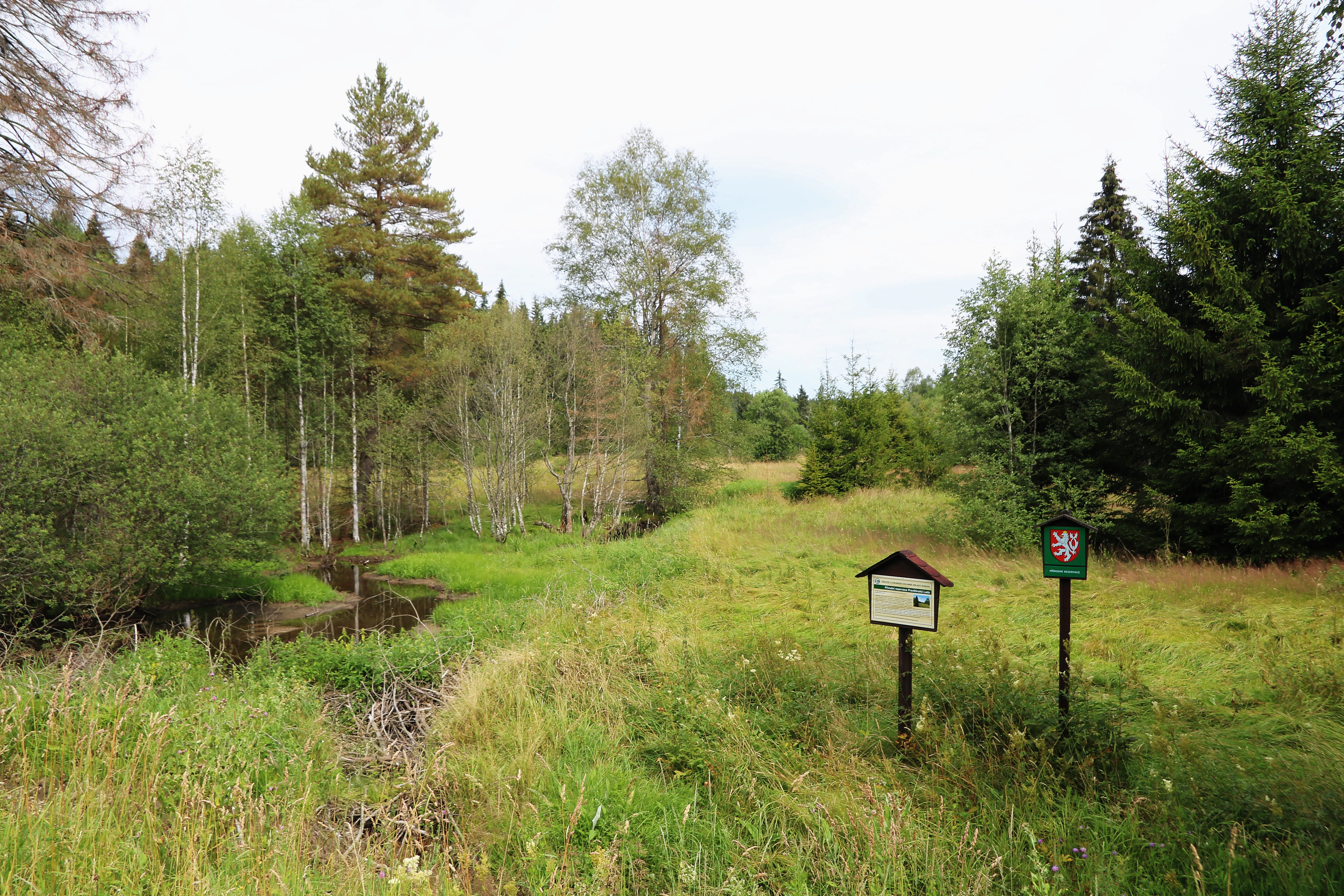
A meadow landscape in Pravětínská Lada nature reserve with a small stream, dense forest edges, and two park signs indicating a protected area.
A view of the Pravětínská Lada nature reserve, featuring wetlands, a stream, and official park signage.

Pravětínská Lada history and protected-area timeline

The reserve was formally declared on 1 September 2000 by the Šumava National Park and Protected Landscape Area administration, reflecting the growing recognition of peatland and abandoned-land habitats as important conservation targets after the fall of the heavily restricted border zone that long shaped land use in this part of the Bohemian Forest.

Historically, the surrounding landscape was shaped by small-scale settlement, including the now vanished hamlet of Zahrádky east of the reserve. Old farmland, pastures, and associated cultural features left a legacy of open ground that, once depopulated, returned to a more natural trajectory. The reserve's designation formalises the value of this recovering landscape, protecting its peatland, springheads, and associated drier communities for their natural development rather than for any continuing agricultural use.

Pravětínská Lada landscape and geographic character

The terrain around Pravětínská Lada lies in the upper part of the Bohemian Forest, with elevations of roughly 848 to 895 meters. The reserve occupies a sloping stretch of the left bank of the Zelenohorský potok valley, a small watercourse that descends toward the Teplá Vltava.

The valley setting combines gentle slopes, seepage zones along the upper edge of the brook, and flatter boggy ground where peat has accumulated. Outside these wetter sections, the relief rises into drier ridges and sunken margins where past human activity left more open ground. The result is a small but varied physical stage, with a wet valley floor embedded in a broader transitional landscape between forest and recovering open land.
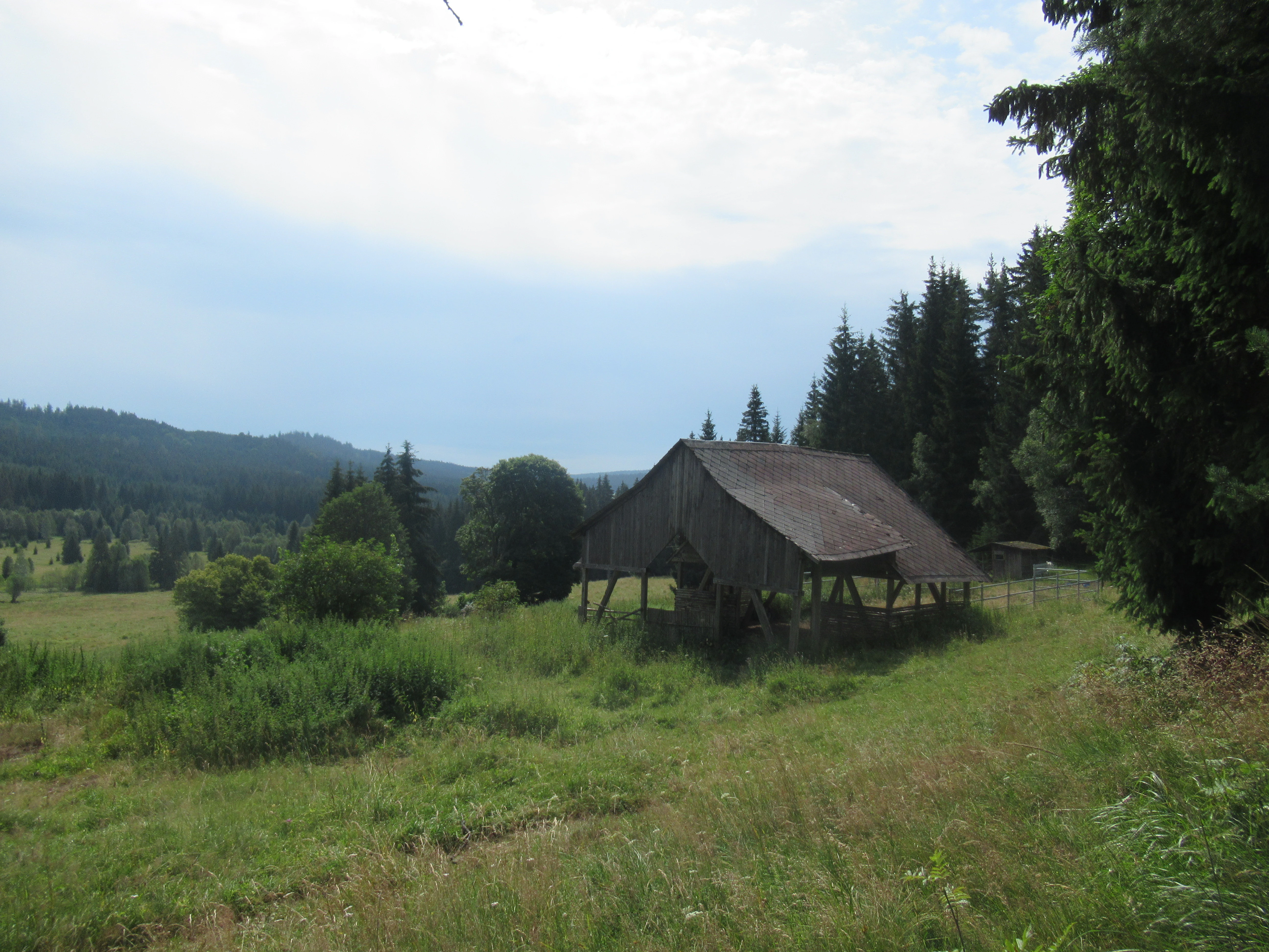
A weathered wooden barn sits in a grassy meadow, with a coniferous forest and rolling hills in the background under a pale, cloudy sky.
Remnants of the former settlement at Pravětínská Lada in a meadow setting.

Pravětínská Lada ecosystems, habitats, and plant life

Ecologically, Pravětínská Lada is dominated by the overlap between peatland and surrounding non-peat habitats. The core of the reserve is a peat bog, fed by a natural spring and supporting classic bog vegetation, with the entire system shaped by constant, slow water movement and the development of peat over decades.

Around this wet core, the reserve includes springs, small mires, and seasonally saturated meltwater areas. Beyond the wetland edge lie drier habitats that occupy abandoned former agricultural soils. Here, vegetation is shifting naturally toward open, drought-tolerant communities, creating a juxtaposition of wet bog and dry, recovering ground within a single small protected area. This mosaic is exceptionally well developed on a local scale and gives the site a concentration of contrasting habitat types that is rare within such a compact footprint.

Pravětínská Lada wildlife and species highlights

The reserve's small size and habitat mosaic support species typical of the Bohemian Forest wetlands and recovering open ground. Bog and spring-edge habitats provide conditions for moisture-loving invertebrates and amphibians, while the open, drier margins create nesting and foraging niches that are scarce in the surrounding dense forest. The wider Šumava context means the reserve also functions as part of a larger network of habitats used by characteristic forest, wetland, and edge species of the Bohemian Forest.

Pravětínská Lada conservation status and protection priorities

Pravětínská Lada is classified as an IUCN Category IV protected area, focused on the conservation of particular species or habitats. The primary objective is to allow the naturally developing plant communities on the peatland, springs, mires, and surrounding dry sites on former farmland to evolve without significant human interference.

By combining active bog and spring protection with the preservation of natural succession on former arable land, the reserve contributes to broader Šumava conservation priorities, especially the safeguarding of peat-accumulating systems and of transitional landscapes shaped by the retreat of traditional mountain agriculture.

Pravětínská Lada cultural meaning and human context

The cultural backdrop of the reserve is closely tied to the marginal agricultural history of the Bohemian Forest. The small vanished settlement of Zahrádky, once located east of the protected area, and the surviving hamlet of Černá Lada reflect a pattern of tiny, fragile mountain communities whose livelihoods depended on the same soils and pastures that now form the drier parts of the reserve. Near the site, a registered memorial tree, Tis na Pravětínských Ladech, still marks the traditional cultural landscape of the area.

Top sights and standout views in Pravětínská Lada

The principal highlights of Pravětínská Lada are its peat bog, its springheads, and the unusual juxtaposition of wet and recovering dry habitats on former farmland. Because the entire mosaic is concentrated in a very small area, the reserve offers unusually high ecological density for its size and is closely connected to the wider Šumava conservation complex.

Best time to visit Pravětínská Lada

Late spring and early autumn tend to offer the most rewarding conditions for visiting bog and wetland landscapes of this kind, when temperatures are mild, peatland vegetation is active, and the open dry edges of the reserve are accessible on foot. Summer visits can be damp and insect-rich around the wet core, while winter often covers the area in snow, softening the contrast between the bog and the surrounding forest. Visitors should generally expect a high-elevation Bohemian Forest climate, with cool weather, frequent moisture, and ground conditions that reflect the reserve's overall wetland character.


Monthly climate preview

Long-term representative point measurements for annual weather patterns in Jihočeský kraj

Pravětínská Lada Climate Normals: Measured Temperature and Precipitation Rhythm

Representative point records for Pravětínská Lada document a measured baseline spanning sub-zero winter minimums to warm summer maximums alongside steady daily precipitation rates. Reviewing the complete twelve-month profile provides deeper context on long-term temperature swings and monthly precipitation trends across the protected area.
Annual mean7 °C
-3 °C18 °C
Jan-3°
Feb-2°
Mar
Apr
May12°
Jun16°
Jul18°
Aug17°
Sep13°
Oct
Nov
Dec-2°
Warmest month
July

17.5 °C

Coolest month
January

-3.4 °C

Wettest month
June

3.3 mm/day

Driest month
April

1.6 mm/day

Park location guide

Geography guide, regional context, and park location map for Pravětínská Lada

Pravětínská Lada park geography, regions, and map view in Czechia

Understand where Pravětínská Lada sits in Czechia through a broader geographic reading of the surrounding landscape, nearby location context, and its mapped position within the national park landscape.

How Pravětínská Lada fits into Czechia

Czech Republic is a landlocked Central European country with a population of approximately 10.9 million people. The nation was established as an independent state on January 1, 1993, following the dissolution of Czechoslovakia. Its capital and largest city is Prague, with other major urban centers including Brno, Ostrava, Plzeň, and Liberec.

Wider geography shaping Pravětínská Lada in Czechia

The Czech Republic is a landlocked country in Central Europe. It is bordered by Germany to the west, Austria to the south, Poland to the northeast, and Slovakia to the southeast. The landscape is predominantly hilly, with the territory covering 78,871 square kilometers.

Map view of Pravětínská Lada

Use this park location map to pinpoint Pravětínská Lada in Czechia, understand its exact geographic position, and read its mapped placement within the surrounding landscape more clearly.

Pigeon | © OpenStreetMap contributors

Location context for Pravětínská Lada

Jihočeský kraj

Visual reference of peat bogs, springhead zones, and wetland habitats in the Bohemian Forest

Pravětínská Lada Photos and Landscape Scenery

Visual records capture the distinctive peat bogs, springheads, and wetland mosaics that define the protected terrain of Pravětínská Lada. Studying these environmental photographs reveals how recovering farmland and wet valley floors merge within the broader Bohemian Forest ecosystem.

A meadow landscape in Pravětínská Lada nature reserve with a small stream, dense forest edges, and two park signs indicating a protected area.

A metal cross stands in a woodland setting between two large, mature tree trunks, surrounded by green foliage.

A weathered wooden barn sits in a grassy meadow, with a coniferous forest and rolling hills in the background under a pale, cloudy sky.

Park atlas

Compare regional wetland habitats and connected conservation terrain across southern Czechia

Explore Parks Near Pravětínská Lada and Surrounding Bohemian Forest Protected Areas

Browse other protected areas near Pravětínská Lada to examine similar peat bog ecosystems, valley headwaters, and transitional forest landscapes. Continuing the geographic comparison reveals broader ecological patterns across the wider Šumava conservation region.
Watercolor illustration of a river flowing through a forested landscape with rolling hills in the background
National parkSouth Bohemian Region
About 1.5 km away#1 closest

West

Šumava National Park: Czech Republic's Premier Forested National Park and Protected Landscape

Explore the unique glacial lakes, peat bogs, and regional geography.

Šumava National Park, situated in the South Bohemian Region of the Czech Republic, is the nation's largest protected area and a vital component of Central Europe's forest ecosystems. This entry details its expansive terrain, highlighting the significant peat bog complexes and ancient glacial lakes that define its unique landscape. Discover the park's geographic context, mapped boundaries, and its importance as a protected natural asset within the broader regional atlas.

Area
680.64 km²
Established
1991
IUCN
II
Visitors
2M annual
Watercolor painting showing mountains, forests, and valleys in a landscape.
National parkGermany
About 6.1 km away#2 closest

West

Bavarian Forest National Park: Protected Landscape and Regional Geography Atlas

Explore mapped terrain and protected park boundaries in Germany.

Dive into the specifics of Bavarian Forest National Park, a key protected area noted for its distinct landscape and geographic importance. This MoriAtlas entry details the park's mapped boundaries and its setting within the surrounding regional geography, offering a clear atlas-style view of its natural terrain. Understand its identity as a national park and discover its place in Germany's protected lands.

Area
242.45 km²
Established
1970
IUCN
II
Visitors
1.3M annual
Watercolor painting of a grassy meadow bordered by a forest line with soft green and muted earth tones.
Nature reserveJihočeský kraj
About 14 km away#3 closest

North

Rašeliniště u Martinala: A Protected Nature Reserve in the Jihočeský kraj Foothills

Mapping transitional bog ecosystems and submontane habitats

Located in the Šumava foothills, Rašeliniště u Martinala is a protected nature reserve defined by its dual-parcel structure of peat-forming wetlands and juniper-rich dry grasslands. This site acts as a key ecological node, supporting a high density of protected species within the Jáchymovský potok drainage basin and representing a refined example of south Bohemian submontane landscape character.

Area
0.095 km²
Established
2011
IUCN
IV
Relief
Upland
Natural monumentJihočeský kraj
About 18 km away#4 closest

East

V polích Natural Monument: Meadow Conservation in the Jihočeský kraj Region

A protected orchid-rich grassland above the Blanice river valley

V polích is a designated natural monument in the Czech Republic known for its managed hay-meadow habitats. This site plays a vital role in regional conservation by maintaining a rare, species-rich landscape that supports native orchid populations on a sunny, south-east facing slope in the Prachatice District.

Area
0.017 km²
Established
1992
IUCN
IV
Relief
Upland
Watercolor painting of a soft, panoramic landscape with rolling green hills, a gentle path or stream, and misty mountain silhouettes in the background under a pale sky.
Natural monumentStrakonice District
About 23 km away#5 closest

Northeast

Na Opukách Natural Monument: Protected Calcareous Landscapes in Strakonice District

Botanical richness and geological geography of a unique Bohemian hilltop reserve

Na Opukách protects a specialized environment of dry grassland and opuka outcrops that remain rare within the wider Strakonice foothills. This site provides a focused look at how specific sedimentary geology supports diverse orchid populations and hardy meadow flora within a predominantly forested regional geography.

Area
0.348 km²
Established
1996
IUCN
IV
Relief
Upland
A horizontal watercolor illustration depicting rolling green hills in the background, a line of trees in the midground, and a grassy meadow with small white flowers in the foreground.
Natural monumentPrachatice District
About 32 km away#6 closest

East

Mastnice Natural Monument: Protected Stream Valley and Wetland Habitat in Prachatice District

Ecologically significant wet meadow and valley geography in the Czech Republic

Mastnice is a protected natural monument situated within the Prachatice District, characterized by its waterlogged meadows and damp woodland margins along a stream valley. This site serves as a key botanical reserve, offering a rare look at valley wetland ecosystems that provide essential habitats for seasonal flora and diverse local species in the South Bohemian region.

Area
0.011 km²
Established
1988
IUCN
IV
Relief
Upland
A horizontal watercolor painting showing rolling green hills and distant purple ridges against a white background.
Protected landscapeKlatovy District
About 35 km away#7 closest

North

Přírodní park Buděticko: Protected Landscape and Geographic Atlas of Klatovy District

Orchid-rich meadows and riparian terrain in the Bohemian foothills

Přírodní park Buděticko serves as a vital protected landscape in the Klatovy District, characterized by the transition between the Šumava foothills and broader upland plains. This area supports a mosaic of orchid-rich limestone meadows and riparian habitats along the Otava River. Discover the park's geological character and its integration of natural biodiversity with the cultural heritage of southwestern Bohemia.

Area
44 km²
Established
1994
Relief
Upland
Climate
Temperate
A horizontal watercolor illustration of a misty moorland with soft green hills, patches of forest, and marshy foreground vegetation, rendered in a light, atmospheric palette.
Nature reserveLandkreis Regen
About 35 km away#8 closest

West

Rotfilz Nature Reserve: Geographic Profile of a Bavarian Forest Peatland

Protected moorland geography and raised bog pine woodland

Rotfilz is a significant nature reserve situated within the Landkreis Regen district of Lower Bavaria. Known for its mature bog pine woodland and ongoing peatland restoration, this protected area offers a look at the historical moorland mosaic of the Bavarian Forest. The terrain, defined by Pleistocene deposits and a clear hydrological boundary, provides a compact but essential site for studying Central European bog conservation and landform evolution.

Area
12.88 km²
Established
1973
IUCN
IV

Common questions about visiting, size, designation, and location context for Pravětínská Lada

Pravětínská Lada FAQs for park facts, access, geography, and protected area context

Find quick answers about Pravětínská Lada, including protected-area facts, park geography, trail and visitor context, and how the park fits into its surrounding country and regional landscape.
MoriAtlas Explorer

Continue Your Protected Areas Search Across the Global Atlas

Deepen your exploration by continuing the structured search for national parks and protected areas worldwide. Utilize the comprehensive filtering capabilities to compare different conservation landscapes and refine your understanding of global park geography. Discover more about the distribution and characteristics of protected natural areas.

Global natural geography