

Mori Atlas logo
Nature reservePulletop Nature Reserve

Trace the ecological boundaries and semi-arid terrain of this significant inland nature reserve.

Pulletop Nature Reserve: Mallee Woodland Geography and Protected Landscape in New South Wales

Pulletop Nature Reserve protects a vital remnant of semi-arid mallee woodland within the Cobar Peneplain region of western New South Wales. This reserve, characterized by its gently undulating plains and permeable soils, serves as a crucial habitat for the malleefowl. Its landscape consists of multi-stemmed eucalypt forests that provide a window into the original vegetation patterns of inland Australia prior to agricultural development.

mallee woodlandsemi-aridmalleefowlbirdwatchingnature reservestrict nature reserve
A stylized illustration of an Australian dry woodland landscape with eucalyptus-like trees, sparse shrubs, and a rocky ridgeline in the background under a pale sky.

Pulletop Nature Reserve

Nature reserve

Park overview

Structured park overview, official facts, and landscape profile for Pulletop Nature Reserve

Pulletop Nature Reserve park facts, protected area profile, and essential visitor context

Review the core facts for Pulletop Nature Reserve, including designation, size, terrain, visitor scale, habitats, and operating context in one park-focused overview.

About Pulletop Nature Reserve

Pulletop Nature Reserve is a compact but ecologically significant protected area in western New South Wales, set within the semi-arid landscapes of the Cobar Peneplain. Although small in size, it represents one of the more important remnants of native mallee vegetation in the region, an ecosystem that has been heavily reduced by clearing for sheep grazing and cropping since the mid-twentieth century.

The reserve sits in gently undulating country with highly permeable sandy soils and no surface watercourses. Its vegetation ranges from tall shrubland to low open woodland, dominated by multi-stemmed mallee eucalypts. Scattered taller trees such as bimble box add structural variety, while smaller shrubs, wattles, and native grasses form a diverse understorey. The reserve's isolation from surrounding cleared land gives it an unusually intact character for such a heavily modified agricultural landscape.

Ecologically, Pulletop is most significant for its birdlife, particularly the malleefowl population that drew early scientific attention to the site. More than 120 bird species have been recorded here, including honeyeaters, parrots, and small ground-dwelling birds typical of mallee habitats. The reserve also supports a modest but interesting suite of mammals, reptiles, and amphibians adapted to dry inland conditions, while introduced species such as rabbits, hares, foxes, and feral cats present ongoing management challenges.

As a strict nature reserve, Pulletop is managed primarily for conservation rather than recreation. It stands as a quiet but important example of how targeted habitat protection, anchored in early scientific research, can preserve a small slice of an ecosystem that has largely disappeared from the surrounding region.

Quick facts and research context for Pulletop Nature Reserve

Pulletop Nature Reserve is a strict nature reserve (IUCN Category Ia) located in the Cobar Peneplain of New South Wales. It lies approximately 38 kilometers north of Griffith and 22 kilometers southwest of Rankins Springs. The reserve covers about 145 hectares of mallee shrubland and low woodland and is managed by the NSW National Parks and Wildlife Service.

Established in January 1963, the reserve was originally dedicated as Pulletop Faunal Reserve and renamed Pulletop Nature Reserve in 1967. It was created to protect habitat for the malleefowl after decades of agricultural clearing had isolated the area from surrounding mallee landscapes.

Protection and recognition

Review the terrestrial protection scope and historical designation data for Pulletop Nature Reserve.

Pulletop Nature Reserve Protection Status and Designation History

Pulletop Nature Reserve maintains a documented terrestrial protection status established in 1963. Review the official designation history and management scope details associated with this protected area.

Protection details

Protection scope
Terrestrial
Designated year
1963
Transboundary protection
No
Park context

Deeper park guide and search-rich context for Pulletop Nature Reserve

Pulletop Nature Reserve history, landscape, wildlife, and travel context

Explore Pulletop Nature Reserve through its history, landscape character, ecosystems, wildlife, conservation priorities, cultural context, and seasonal travel timing in a structured park guide built for atlas discovery and search intent.

Why Pulletop Nature Reserve stands out

Pulletop Nature Reserve is best known as a protected refuge for the malleefowl, an iconic ground-nesting bird of Australia's semi-arid mallee regions. Between 1951 and 1960, Australian ornithologist Harry Frith used the site to study malleefowl ecology and behavior, producing multiple scientific papers and the book *The Mallee-Fowl: The Bird that Builds an Incubator*. The reserve itself is a classic example of inland mallee woodland, dominated by species such as white mallee, narrow-leaved red mallee, red mallee, and yorrell. Its establishment marked one of the early formal conservation efforts in New South Wales aimed specifically at preserving the habitat of a single threatened species whose environment was rapidly disappearing under agricultural development.
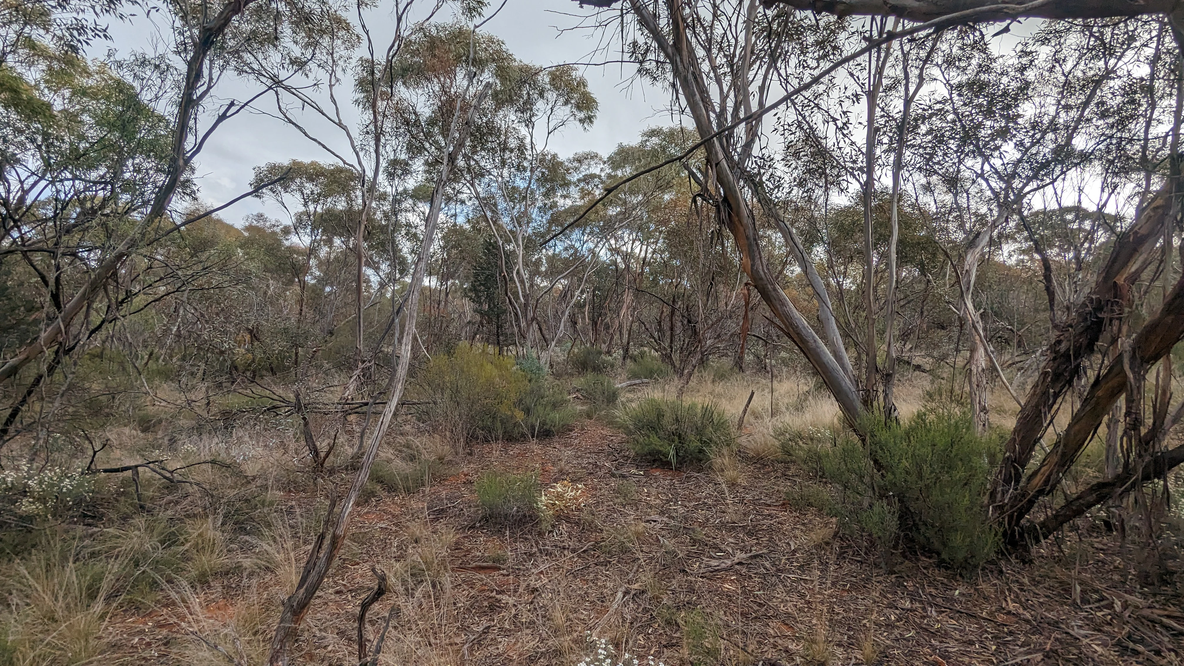
A view of dry mallee woodland with multi-stemmed eucalyptus trees, sparse shrubbery, and leaf litter covering the ground.
Mallee woodland vegetation in Pulletop Nature Reserve, New South Wales.

Pulletop Nature Reserve history and protected-area timeline

The land that now makes up Pulletop Nature Reserve was once part of a privately owned property in western New South Wales known as Homestead Farm. During the 1950s, much of the surrounding countryside was progressively cleared to expand sheep grazing and crop production, gradually isolating a patch of intact mallee vegetation from the broader landscape.

Between 1951 and 1960, Australian ornithologist Harry Frith used this isolated stand of mallee as a field site for studying the ecology and behavior of the malleefowl, a ground-dwelling bird famous for constructing large incubator-like nest mounds. His years of field research there informed nine scientific papers and culminated in the 1962 publication of *The Mallee-Fowl: The Bird that Builds an Incubator*, a landmark work on the species' breeding biology, distribution, predation, and conservation needs.

Concern about the long-term survival of malleefowl in the face of ongoing habitat loss prompted conservation action. In December 1960, 145 hectares of the property were withdrawn from sale, removing the land from the threat of further agricultural development. In January 1963, the area was formally dedicated as Pulletop Faunal Reserve, establishing it as a protected area focused on the conservation of mallee fauna. The reserve was renamed Pulletop Nature Reserve in 1967, reflecting a broader conservation mandate, and it remains managed today by the NSW National Parks and Wildlife Service.

Pulletop Nature Reserve landscape and geographic character

The landscape of Pulletop Nature Reserve is shaped by the broad, gently undulating plains of the Cobar Peneplain in western New South Wales. The terrain is essentially flat to very gently undulating, with no defined watercourses, drainage lines, or persistent surface water. Soils are highly permeable, and rainfall is absorbed rapidly into the ground rather than running off into creeks or channels.

This combination of flat topography and well-drained soils supports a vegetation pattern characteristic of inland semi-arid Australia. Rather than dramatic relief or striking landforms, the reserve presents a quiet, open vista of low mallee woodland and tall shrubland, with multi-stemmed eucalypts rising in sparse clumps above a varied understorey of shrubs, wattles, and grasses.

The surrounding region has been heavily cleared for agriculture, so the reserve stands as a relatively intact patch of an ecosystem that once extended much more widely across this part of New South Wales. Its visual character is one of subtle, understated Australian bush rather than grand scenery, offering an impression of the original mallee country that dominated the area before twentieth-century land development.

Pulletop Nature Reserve ecosystems, habitats, and plant life

Pulletop Nature Reserve protects a representative example of inland mallee vegetation, an ecosystem type adapted to low rainfall, nutrient-poor sandy soils, and frequent drought. The dominant vegetation is tall shrubland grading into low open woodland, with the canopy heavily dominated by mallee eucalypts that grow in characteristic multi-stemmed forms rather than as tall single-trunked trees.

Four primary mallee species make up most of the woodland: white mallee, narrow-leaved red mallee, red mallee, and yorrell. Taller tree species such as bimble box occur scattered through the reserve, while a diverse understorey includes broombush, mallee pine, streaked wattle, desert quandong, wedge-leaf hop-bush, smooth wallaby-bush, spinifex, and various native grasses such as small-flowered wallaby-grass, tall feather-grass, and five-minute grass.

The herbaceous layer also supports a suite of small native wildflowers and terrestrial orchids, including annual bluebell, dwarf greenhood, blue fingers, pink fingers, and blunt greenhood. Together, these plant communities give the reserve an ecosystem that, while modest in scale, expresses the full structural and floristic character of the mallee habitats that once extended across this part of western New South Wales.

Pulletop Nature Reserve wildlife and species highlights

Wildlife is a defining feature of Pulletop Nature Reserve, and the reserve's fauna record reflects its role as a refuge for species that have largely disappeared from the surrounding cleared farmland. More than 120 mallee and woodland bird species have been recorded within the reserve, making it an important site for bird diversity in the region.

The malleefowl is the species most strongly associated with the reserve. It was the focus of Harry Frith's long-term ecological research here and remains the species for which the reserve was originally protected. Several other woodland and mallee bird species are regularly sighted, including weebill, spiny-cheeked honeyeater, white-eared honeyeater, yellow-plumed honeyeater, grey shrikethrush, Australian ringneck, and greater bluebonnet. At least 14 bird species listed under New South Wales' Biodiversity Conservation Act 2016 have been recorded in the reserve.

Over time, some species have been lost locally. Malleefowl, red-lored whistler, and southern scrub-robin were present in the reserve until the mid to late 1980s and are now considered locally extinct there. Chestnut quail-thrush, Gilbert's whistler, and shy heathwren have also declined sharply and, if they still occur, survive only in very low numbers.

Mammals recorded at Pulletop include eastern grey kangaroo, western grey kangaroo, short-beaked echidna, and slender-tailed dunnart. Reptiles and amphibians present include sand goanna, shingleback skink, common bluetongue, pobblebonk, and spotted marsh frog. Introduced species such as European rabbit, brown hare, European red fox, and feral cat are also present and represent an ongoing challenge for native wildlife conservation.

Pulletop Nature Reserve conservation status and protection priorities

Pulletop Nature Reserve holds real conservation significance despite its small size, primarily because it preserves a remnant of mallee habitat that would almost certainly otherwise have been lost to agricultural clearing. The reserve was established specifically to safeguard habitat for the malleefowl, a species whose broader environment in western New South Wales was being rapidly fragmented and degraded during the mid-twentieth century.

As an IUCN Category Ia strict nature reserve, Pulletop is managed primarily for ecosystem and species protection rather than public recreation. Its protected status has helped maintain ecological processes and native vegetation cover across more than 145 hectares in a region otherwise dominated by sheep grazing and cropping.

The reserve also carries broader conservation importance because of the long-running scientific work carried out there. Harry Frith's decade of field research at Pulletop made the site an early benchmark for understanding malleefowl ecology in Australia, and the reserve continues to be a reference site for the conservation needs of mallee fauna. At the same time, the decline and local loss of several bird species, including malleefowl itself in recent decades, highlights the ongoing pressures facing small, isolated reserves, especially from introduced predators and habitat fragmentation.

Pulletop Nature Reserve cultural meaning and human context

Pulletop Nature Reserve lies within Wiradjuri country, the traditional land of the Wiradjuri people of inland New South Wales. Detailed records of Aboriginal use of the specific reserve area are not known, but significant Aboriginal sites are documented in nearby Cocoparra National Park, about 10 kilometers to the east.

Given that Cocoparra's mallee landscapes share their character with the country around Pulletop, it is reasonable to infer that Aboriginal hunting, travel, and use of natural resources would have extended across this broader mallee region. However, the specific cultural record for the reserve itself remains limited, and the reserve's modern identity is far more strongly tied to its role in twentieth-century wildlife conservation than to documented Indigenous land-use history.

Top sights and standout views in Pulletop Nature Reserve

Pulletop's standout quality is its concentration of conservation significance within a very compact footprint: a small mallee reserve created specifically to protect malleefowl habitat in a region where clearing had already isolated the remaining bush. Its association with Harry Frith's pioneering 1950s ornithological research gives the reserve a place in the history of Australian bird conservation.

The reserve also offers a fine representation of inland mallee vegetation, from the multi-stemmed eucalypt canopy through the wattles, broombush, desert quandong, and native grasses to the small native orchids and wildflowers of the ground layer. More than 120 bird species, several state-listed threatened species, and a typical suite of dry-country mammals, reptiles, and frogs add further ecological value to what is otherwise a modest, low-relief landscape.

Best time to visit Pulletop Nature Reserve

Pulletop Nature Reserve sits in a semi-arid part of western New South Wales, so seasonal conditions shape the experience of the landscape more than dramatic scenery does. Spring is generally the most rewarding period to visit, when cooler temperatures combine with wildflower displays, including native terrestrial orchids such as dwarf greenhood, blue fingers, and pink fingers, and when bird activity tends to be at its peak.

Autumn also offers pleasant weather for exploring the mallee without the heat of mid-summer. Summer in this part of New South Wales can be extremely hot and dry, and conditions for walks or birdwatching during the middle of the day can be harsh. Winter tends to bring cooler nights and mild days, and can be a quiet, contemplative time to experience the mallee woodland in its more subdued seasonal character.
Monthly climate preview

Long-term monthly temperature and precipitation rhythm for New South Wales

Pulletop Nature Reserve Climate Profile and Annual Temperature Normals

Representative coordinate measurements reveal the measured annual temperature range and steady precipitation rhythm across Pulletop Nature Reserve. Examining the full monthly climate normals provides deeper insight into long-term thermal variations and precipitation patterns.
Annual mean17 °C
9 °C27 °C
Jan27°
Feb26°
Mar22°
Apr17°
May13°
Jun10°
Jul
Aug10°
Sep13°
Oct17°
Nov21°
Dec24°
Warmest month
January

27 °C

Coolest month
July

8.6 °C

Wettest month
February

1.4 mm/day

Driest month
April

0.8 mm/day

Park location guide

Geography guide, regional context, and park location map for Pulletop Nature Reserve

Pulletop Nature Reserve park geography, regions, and map view in Australia

Understand where Pulletop Nature Reserve sits in Australia through a broader geographic reading of the surrounding landscape, nearby location context, and its mapped position within the national park landscape.

How Pulletop Nature Reserve fits into Australia

Australia is a constitutional monarchy and federal parliamentary democracy comprising six states and ten territories. With a population of nearly 28 million, it is one of the world's most urbanised countries, with most people concentrated on the eastern seaboard. The country has a high Human Development Index and is known for its cultural diversity, ancient Aboriginal heritage, and unique wildlife.

Wider geography shaping Pulletop Nature Reserve in Australia

Australia occupies the entire Australian continent, the island of Tasmania, and numerous smaller islands. It is the world's flattest and driest inhabited continent, featuring vast deserts in the interior (the Outback), tropical rainforests along the eastern coast, and a coastline bordering the Indian and Pacific Oceans.

Map view of Pulletop Nature Reserve

Use this park location map to pinpoint Pulletop Nature Reserve in Australia, understand its exact geographic position, and read its mapped placement within the surrounding landscape more clearly.

Pigeon | © OpenStreetMap contributors

Location context for Pulletop Nature Reserve

New South Wales

Visual exploration of semi-arid terrain, shrubland, and protected habitats in western New South Wales

Pulletop Nature Reserve Photos and Mallee Woodland Landscapes

Visual records capture the low mallee woodland, multi-stemmed eucalypt canopies, and sparse shrub layers that define the protected terrain of Pulletop Nature Reserve. Photographic documentation reveals the quiet open character of the Cobar Peneplain, illustrating native vegetation remnants and wildlife habitats preserved within agricultural plains.

A view of dry mallee woodland with multi-stemmed eucalyptus trees, sparse shrubbery, and leaf litter covering the ground.

A green and white rectangular sign reading Pulletop Nature Reserve stands in front of a dry, sparse forest of mallee trees and reddish soil.

Park atlas

Compare surrounding mallee woodland reserves and regional conservation landscapes

Explore Protected Areas and Parks Near Pulletop Nature Reserve in New South Wales

Browse nearby national parks and protected areas sharing the semi-arid terrain of the Cobar Peneplain. Comparing these regional conservation sites reveals the broader ecological context surrounding Pulletop Nature Reserve.
National parkRiverina
About 14 km away#1 closest

Southeast

Cocoparra National Park: Semi-Arid Hill Country and Protected Landscape in Riverina

Explore mapped geography and key natural features of this Australian national park.

Cocoparra National Park is an essential protected natural area within Australia's Riverina region, noted for its striking semi-arid landscape. The park features a prominent range of low hills, including Bingar Mountain, rising from the predominantly flat terrain. This distinctive geography, characterized by rocky sandstone ridges and characteristic woodland communities, offers valuable insights into the region's natural heritage. As an Important Bird Area, Cocoparra National Park also holds significant conservation value for its avian populations and their unique inland habitat.

Area
83.57 km²
Established
1969
IUCN
II
Relief
Mixed relief
National parkNew South Wales
About 84 km away#2 closest

South

Murrumbidgee Valley National Park: National Park with Mapped Protected Boundaries in New South Wales

Regional geography and landscape context for this protected area.

Murrumbidgee Valley National Park is recognized as a national park, offering critical insights into protected land distribution within New South Wales. This destination facilitates an atlas-style exploration of its geographic identity, mapped boundaries, and its role as a defined natural landscape within the broader region. Understanding this park's protected status and geographic placement is key for detailed map-based discovery.

Area
477.03 km²
Established
2010
IUCN
II
Relief
Lowland
Nature reserveNew South Wales
About 99 km away#3 closest

East

Charcoal Tank Nature Reserve: Mapped Protected Landscapes and Regional Geography in New South Wales

Critical mallee-broombush woodland and avian refuge in a fragmented agricultural corridor

Charcoal Tank Nature Reserve stands as a vital 86-hectare protected site in central western New South Wales, preserving rare mallee and mallee-broombush woodland that has been largely cleared elsewhere. This documentation maps the reserve's unique position within the regional agricultural matrix, detailing its significance as an long-studied avian habitat and a sanctuary for native species struggling in a fragmented, semi-arid environment.

Area
0.86 km²
Established
1966
IUCN
Ia
Relief
Lowland
National parkNew South Wales
About 102 km away#4 closest

Southwest

Oolambeyan National Park National Park: Discover its Mapped Geography and Protected Landscape

Explore the protected area and regional context of New South Wales.

Delve into Oolambeyan National Park, a key national park within New South Wales, Australia. This entry provides essential geographic context, detailing the park's mapped boundaries and its identity as a protected landscape. It serves as a foundation for understanding the park's contribution to the regional atlas and offers a distinct perspective on the natural geography of the area.

Area
222.31 km²
Established
2001
IUCN
II
Access
Moderate access
National parkNew South Wales
About 121 km away#5 closest

Northwest

Willandra National Park: National Park Protected Landscape & Geographic Context

Discover mapped boundaries within this New South Wales protected area.

Willandra National Park is a designated national park in New South Wales, Australia, offering focused opportunities for understanding protected landscapes. This entry provides essential geographic context and highlights the importance of mapped park boundaries for atlas-driven exploration. Users can engage with the park's specific landscape identity and its contribution to the broader regional geography of New South Wales through structured data.

Area
193.86 km²
Established
1972
IUCN
II
Relief
Lowland
Nature reserveNew South Wales
About 137 km away#6 closest

Southeast

Ingalba, Big Bush and Pucawan Nature Reserves: Regional Geography and Protected Woodland Map

Inland New South Wales conservation complex within the Lachlan Fold Belt

These three nature reserves function as one of the most substantial surviving remnants of mugga ironbark and western grey box woodland in southern inland New South Wales. Located west of Temora, the reserves protect forty-nine square kilometres of distinct woodland and dry heathland communities that provide essential habitat corridors across a heavily cleared agricultural region. The mapping highlights the unique topography and geological variety that sustains this protected landscape.

Area
49.27 km²
IUCN
Ia
Relief
Upland
Climate
Temperate
Nature reserveNew South Wales
About 145 km away#7 closest

South

Lake Urana Nature Reserve: Geographic Atlas and Protected Area Mapping in Riverina

Inland salt-lake systems and dry box-pine woodland habitats

Lake Urana Nature Reserve functions as a representative protected zone within the Riverina region of New South Wales. The landscape transitions from the ephemeral salt-lake shoreline to native box-pine forests. This atlas entry details the protected boundaries and ecological characteristics of these arid-adapted inland plant communities and their role within the wider plains habitat network.

Area
3.02 km²
Established
1996
IUCN
Ia
Relief
Lowland
Nature reserveNew South Wales
About 147 km away#8 closest

East

Boginderra Hills Nature Reserve: Protected Granite Landscapes in New South Wales

An ecological map of the Riverina woodland refuge.

Boginderra Hills Nature Reserve protects a distinct granite ridge that remains largely intact amidst the heavily modified plains of the Riverina. This site functions as a strictly managed conservation area, preserving a mosaic of native eucalypt and cypress pine communities that provide essential habitat for regional woodland bird species and other native fauna.

Area
7.56 km²
Established
1982
IUCN
Ia
Relief
Upland

Common questions about visiting, size, designation, and location context for Pulletop Nature Reserve

Pulletop Nature Reserve FAQs for park facts, access, geography, and protected area context

Find quick answers about Pulletop Nature Reserve, including protected-area facts, park geography, trail and visitor context, and how the park fits into its surrounding country and regional landscape.
MoriAtlas Explorer

Continue Your Protected Areas Search Across the Global Atlas

Deepen your exploration by continuing the structured search for national parks and protected areas worldwide. Utilize the comprehensive filtering capabilities to compare different conservation landscapes and refine your understanding of global park geography. Discover more about the distribution and characteristics of protected natural areas.

Global natural geography