Mori Atlas logo
National parkQuiçama National Park

Explore the mapped boundaries and regional geography of this significant protected area.

Quiçama National Park: Discover Angola's Protected National Park Landscape

(Parque Nacional do Quiçama)

Quiçama National Park stands as a key protected landscape within Angola, offering a distinct geographic context for atlas exploration. This page details the park's identity as a national park, focusing on its position within the country's natural terrain and regional geography. Understand the mapped boundaries and landscape character that define Quiçama National Park for structured discovery and geographic understanding.

Coastal Protected AreaWildlife Recovery Success StoryElephant ConservationSavanna EcosystemAfrican National ParkUNESCO Biosphere Reserve

Quiçama National Park

National park

Park overview

Structured park overview, official facts, and landscape profile for Quiçama National Park

Quiçama National Park park facts, protected area profile, and essential visitor context
Review the core facts for Quiçama National Park, including designation, size, terrain, visitor scale, habitats, and operating context in one park-focused overview.

About Quiçama National Park

Quiçama National Park represents Angola's primary hope for establishing a meaningful national park system in a country that once possessed extensive wildlife resources but has lost most of its protected areas to decades of conflict. The park's location approximately 70 kilometers from Luanda makes it the most accessible significant protected area for both the capital's population and international visitors, positioning it as the gateway to Angolan nature tourism. The park's vast expanse of nearly 10,000 square kilometers encompasses multiple habitat types, from coastal dunes and mangrove systems along its Atlantic front to interior savanna landscapes that historically supported abundant large mammal populations. The Cuanza River, Angola's longest river, forms a critical water source and ecological corridor along the park's northern boundary, while the Longa River to the south provides additional hydrological importance. The post-civil war restoration effort led by the Kissama Foundation has transformed Quiçama from a depleted wildlife landscape into a functioning ecosystem once again, with introduced elephant populations establishing sustainable herds that now roam the savanna. The 2025 UNESCO biosphere reserve designation acknowledges both the park's ecological significance and its potential as a model for sustainable development in the region.

Quick facts and research context for Quiçama National Park

Quiçama National Park lies in northwestern Angola, approximately 70 kilometers southeast of Luanda, the nation's capital. The protected area spans roughly 9,960 square kilometers, making it larger than the entire U.S. state of Rhode Island. Its western edge fronts 120 kilometers of Atlantic Ocean coastline, while the Cuanza River and Longa River define its northern and southern boundaries respectively. The park was established as a game reserve in 1938 and upgraded to national park status in 1957 during the Portuguese colonial period. It holds IUCN Category II protection status and was designated a UNESCO biosphere reserve in 2025. The Kissama Foundation, a collaboration between Angolan and South African conservationists, has driven much of the park's post-war restoration efforts since 2001.

Park context

Deeper park guide and search-rich context for Quiçama National Park

Quiçama National Park history, landscape, wildlife, and travel context
Explore Quiçama National Park through its history, landscape character, ecosystems, wildlife, conservation priorities, cultural context, and seasonal travel timing in a structured park guide built for atlas discovery and search intent.

Why Quiçama National Park stands out

Quiçama National Park is best known as the sole functioning protected area in Angola and as the site of Operation Noah's Ark, the largest animal translocation project in history. The initiative successfully reintroduced elephants and other large mammals from overpopulated parks in Botswana and South Africa, fundamentally transforming the park's ecological landscape after decades of civil war had eliminated nearly all wildlife populations. The park is also renowned for its significant elephant herds, its population of giant sable antelope (a species endemic to Angola), and its designation as a Lion Conservation Unit since 2005. Its 120-kilometer Atlantic coastline provides additional distinction as one of the few coastal national parks in southern Africa.

Quiçama National Park history and protected-area timeline

The area that now comprises Quiçama National Park was first protected as a game reserve in 1938 during the Portuguese colonial period in Angola. In January 1957, the Portuguese administration of the Overseas Province of Angola formally proclaimed the area a national park, establishing one of the earliest protected area designations in Central Africa. Prior to Angola's long civil war (1975-2002), the park supported abundant populations of large game animals including African bush elephants and the critically endangered Giant Sable Antelope, a species endemic to the region. Twenty-five years of civil conflict led to widespread poaching that virtually eliminated the park's wildlife populations, leaving the protected area functionally empty despite its formal designation remaining in place. In 2001, the Kissama Foundation, an organization bringing together Angolan and South African conservationists, launched Operation Noah's Ark to systematically reintroduce wildlife, particularly elephants, from overpopulated parks in Botswana and South Africa. This unprecedented initiative, the largest animal transplant in history, successfully established new herds that have adapted well to the Quiçama environment. The park has been recognized as a Lion Conservation Unit since 2005, and in 2025 was designated a UNESCO biosphere reserve by the World Network of Biosphere Reserves.

Quiçama National Park landscape and geographic character

Quiçama National Park occupies a diverse coastal and interior landscape in northwestern Angola. The protected area spans approximately 9,960 square kilometers along the Atlantic Ocean, with 120 kilometers of coastline defining its western boundary. The landscape transitions from coastal dunes and beach environments through a narrow coastal plain to interior savanna and woodland areas. The Cuanza River, Angola's longest river system, forms a natural boundary along the northern edge of the park, creating an important riparian corridor and water source for wildlife. The Longa River similarly defines the southern border, completing a hydrological framework that supports the park's ecology. The terrain generally consists of gently rolling plains interspersed with isolated hills and rocky outcrops, characteristic of the Angolan coastal plain. The combination of ocean frontage, river boundaries, and interior savanna creates a mosaic of habitats that support the park's recovering wildlife populations.

Quiçama National Park ecosystems, habitats, and plant life

The ecological character of Quiçama National Park reflects its position in the Guineo-Congolian forest-savanna mosaic that characterizes much of central Africa. The park's coastal location and river boundaries create a diversity of habitats ranging from marine and mangrove environments along the Atlantic coast to riparian woodlands along the Cuanza and Longa rivers, transitioning to savanna grasslands and woodland in the interior. Historically, the park supported one of the most significant wildlife populations in Angola, with particular importance for large mammals. The post-conflict restoration through Operation Noah's Ark has reestablished elephant populations that now form sustainable herds across the landscape. The park's designation as a Lion Conservation Unit since 2005 reflects its importance for apex predator conservation in the region. The recovery of the park's ecosystems represents a remarkable ecological success story, demonstrating the potential for restored functionality in degraded African protected areas when given appropriate protection and management investment.

Quiçama National Park wildlife and species highlights

Quiçama National Park's wildlife heritage centers on its large mammal populations, particularly elephants that have been reintroduced through the landmark Operation Noah's Ark initiative. The park historically supported populations of African bush elephants and the Giant Sable Antelope, a species endemic to Angola that remains one of Africa's most critically endangered antelopes. Though the original populations were decimated during the civil war, the reintroduction program from Botswana and South Africa has reestablished viable elephant herds that now roam the park's savanna landscapes. The park's designation as a Lion Conservation Unit since 2005 indicates the presence of significant lion populations, making it important for big cat conservation in the region. Beyond the flagship species, the park supports diverse fauna adapted to the savanna and woodland habitats, including various antelope species, primates, and abundant birdlife supported by the river systems and coastal environments.

Quiçama National Park conservation status and protection priorities

Quiçama National Park holds exceptional conservation significance as the only functioning national park in Angola, representing the nation's primary protected area in a country where civil conflict destroyed most of its protected area network. The park's IUCN Category II designation reflects its primary conservation purpose of protecting natural ecosystems. Its designation as a Lion Conservation Unit since 2005 identifies it as an important area for lion conservation at a regional level. The 2025 UNESCO biosphere reserve designation places Quiçama among the world's recognized important conservation landscapes and provides international frameworks for sustainable development alongside biodiversity protection. The Operation Noah's Ark project represents one of the most ambitious conservation translocations in history, demonstrating innovative approaches to ecosystem restoration in post-conflict environments. The park serves as both a refuge for recovering wildlife populations and a demonstration project for conservation-led recovery in Angola.

Quiçama National Park cultural meaning and human context

Quiçama National Park occupies territory within the cultural landscape of northwestern Angola, an area historically inhabited by various indigenous communities whose relationship with the land predates the colonial period. The park's name derives from the Portuguese rendering of local naming conventions, with Quiçama, Kissama, Kisama, and Quicama representing variations in spelling that reflect both Portuguese colonial influence and local linguistic traditions. The Cuanza River that forms the park's northern boundary has historically served as an important cultural and economic corridor for local communities, providing fishing resources and transportation routes. The post-colonial civil war displaced many local communities and disrupted traditional land-use patterns, though the park's restoration creates opportunities for重新 establishing community relationships with the landscape in the context of modern conservation frameworks.

Top sights and standout views in Quiçama National Park

Quiçama National Park stands out as the sole operational national park in Angola, offering visitors access to one of Africa's most ambitious wildlife recovery stories. The park's 120-kilometer Atlantic coastline provides a unique coastal safari experience within the southern African context, combining beach access with wildlife viewing. The elephant populations introduced through Operation Noah's Ark represent the successful establishment of new herds in their historic range, a conservation achievement of global significance. The park's designation as a UNESCO biosphere reserve in 2025 affirms its importance on the international conservation stage. The proximity to Luanda, just 70 kilometers away, makes Quiçama the most accessible major protected area for visitors to Angola, offering a practical introduction to Angolan nature for both domestic and international travelers.

Best time to visit Quiçama National Park

The optimal period to visit Quiçama National Park corresponds to the dry season from May to October, when reduced rainfall creates more accessible conditions for wildlife viewing and landscape exploration. During these months, animals congregate more predictably around remaining water sources, enhancing sighting opportunities. The wet season from November to April brings green landscapes and productive birdwatching but can restrict some access routes and make wildlife more dispersed. Given the park's coastal setting, the interface between Atlantic weather patterns and interior conditions influences local climate patterns that visitors should consider when planning their trip.

Park location guide

Geography guide, regional context, and park location map for Quiçama National Park

Quiçama National Park park geography, regions, and map view in Angola
Understand where Quiçama National Park sits in Angola through a broader geographic reading of the surrounding landscape, nearby location context, and its mapped position within the national park landscape.

How Quiçama National Park fits into Angola

Angola is a unitary presidential republic on the western coast of Southern Africa. Gaining independence from Portugal in 1975, it borders Namibia, the Democratic Republic of the Congo, Zambia, and the Atlantic Ocean. The country has an exclave province called Cabinda. With a population of over 36 million, Angola is rich in oil and mineral resources.

Wider geography shaping Quiçama National Park in Angola

Angola is located on the western coast of Southern Africa along the Atlantic Ocean. It is bordered by Namibia to the south, the Democratic Republic of the Congo to the north, Zambia to the east, and the Atlantic Ocean to the west. The country includes the exclave province of Cabinda, which borders the Republic of the Congo and the Democratic Republic of the Congo. The terrain includes coastal lowlands, highland plateaus, and interior plains.

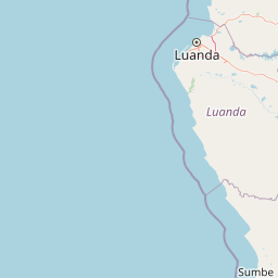
Map view of Quiçama National Park

Use this park location map to pinpoint Quiçama National Park in Angola, understand its exact geographic position, and read its mapped placement within the surrounding landscape more clearly.

Pigeon | © OpenStreetMap contributors
Park atlas

Compare the Regional Spread of Conservation Landscapes and Mapped Protected Areas Surrounding Quiçama National Park, Angola.

Explore Other National Parks and Protected Areas Near Quiçama National Park
After exploring Quiçama National Park, discover other national parks, coastal reserves, and savanna ecosystems across Angola and neighboring regions. Comparing these protected areas provides valuable geographic context for understanding conservation efforts and landscape diversity beyond Angola's flagship park.
National parkMalanje Province

Cangandala National Park: Angola's Protected Landscape in Malanje Province

Discover National Park Geography and Boundaries

Investigate Cangandala National Park, a significant protected area situated in Malanje Province, Angola. This page provides detailed geographic context, focusing on the park's mapped boundaries and its role as a national park within the region's atlas. Explore the fundamental protected landscape characteristics and its specific contribution to Angola's conservation geography, offering a clear entry point for understanding this unique natural area.

Area
600 km²
Established
1970
Relief
Upland
Climate
Tropical
Watercolor painting showing a river with green hills and pink flowers in the foreground
National parkKouilou Department

Conkouati-Douli National Park: Mapping Protected Landscape Boundaries and Regional Geography

Explore its national park status and geographic context.

Conkouati-Douli National Park is a protected area situated in the Kouilou Department, offering a focused point for geographic and landscape discovery. This detail provides an atlas-style perspective on its mapped boundaries and its contribution to the regional geography. Understand the park as a distinct natural landscape and a key component of conservation within its geographic setting.

Area
7,955 km²
Established
1999
IUCN
II
Relief
Lowland
National parkCunene Province

Mupa National Park National Park: Exploring Protected Landscapes and Geographic Context

Discover the mapped terrain and boundaries in Cunene Province.

Mupa National Park is a vital protected area within Cunene Province, Angola, serving as a key component of the region's conservation atlas. This national park represents a distinct geographic entity, offering detailed insights into its mapped landscape and protected boundaries. Users can explore Mupa National Park to understand its specific contribution to the protected lands of southern Angola and to appreciate its unique position within the broader regional geography and natural terrain.

Area
6,600 km²
Established
1964
Access
Access unknown
Scope
Terrestrial
National parkGabon

Mayumba National Park: Gabon's Equatorial Protected Area and Geographic Atlas

Explore mapped park boundaries and regional landscape context.

Delve into the geographic identity of Mayumba National Park, a significant protected area situated in Gabon. This detail page provides atlas-style insights into the park's mapped boundaries, its position within the equatorial geography of Central Africa, and its role as a national park. Understand the protected landscape's environmental context and its atlas significance.

Area
870 km²
Established
2002
IUCN
II
Relief
Lowland
National parkNamibe Province

Iona National Park: Mapped Protected Landscape in Namibe Province, Angola

Explore the geographic extent and regional context of this national park.

Iona National Park stands as a protected natural area within the administrative region of Namibe Province, Angola. This atlas-focused entry provides detailed insights into the park's mapped boundaries, its regional geographic positioning, and its role as a conservation landscape. Users can engage with specific data to understand the terrain and protected land distribution within this significant Angolan national park.

Area
15,200 km²
Established
1964
IUCN
II
Relief
Mixed relief
National parkHaut-Ogooué Province

Batéké Plateau National Park: Mapped Geography of a Central African Forest-Savanna Mosaic

Discover the terrain and protected landscape of Haut-Ogooué Province.

Batéké Plateau National Park is defined by its expansive forest-savanna mosaic, a rare ecological formation across Central Africa. Located within Haut-Ogooué Province, this national park showcases unique terrain characterized by savanna grasslands interspersed with woodlands and forested corridors. Understanding its geographic context and protected boundaries provides valuable insight into the region's natural heritage and conservation significance.

Area
2,034 km²
Established
2002
IUCN
II
Relief
Upland
National parkGabon

Moukalaba-Doudou National Park: Gabon's Forest-Savanna Mosaic Protected Landscape

Atlas exploration of unique habitats and geographic boundaries.

Moukalaba-Doudou National Park in Gabon offers a distinctive atlas exploration experience, characterized by its remarkable combination of humid tropical rainforest and savanna grasslands. Covering a vast area, this protected landscape provides critical habitat and showcases a rare ecological transition zone within Central Africa. Understanding its mapped geography and protected-area status is key to appreciating Gabon's conservation efforts and the diverse natural terrains it preserves.

Area
4,500 km²
IUCN
II
Scope
Terrestrial
Water
Minor water
National parkGabon

Birougou National Park: Mapped Protected Landscape and Regional Geography in Gabon

Explore the geographic extent and conservation context of this national park.

Birougou National Park is an important protected area situated in Gabon, offering a distinct focus for geographic and atlas-based discovery. This national park serves as a significant element within the country's network of conservation landscapes, providing a focal point for understanding mapped terrain and regional geographic patterns. Users can explore its protected boundaries and gain insight into its specific environmental context within Central Africa, making it a vital entry for atlas exploration of Gabon's natural heritage.

Area
690 km²
Established
2002
IUCN
II
Relief
Mountain

Common questions about visiting, size, designation, and location context for Quiçama National Park

Quiçama National Park FAQs for park facts, access, geography, and protected area context
Find quick answers about Quiçama National Park, including protected-area facts, park geography, trail and visitor context, and how the park fits into its surrounding country and regional landscape.
MoriAtlas Explorer

Continue Your Protected Areas Search Across the Global Atlas

Deepen your exploration by continuing the structured search for national parks and protected areas worldwide. Utilize the comprehensive filtering capabilities to compare different conservation landscapes and refine your understanding of global park geography. Discover more about the distribution and characteristics of protected natural areas.

Global natural geography