

Mori Atlas logo
Protected areaRas ash-Shaq'a

A historic Mediterranean headland characterized by dramatic limestone cliffs and protected wetland habitats.

Ras ash-Shaq'a: Investigating the Coastal Geography and Protected Landscapes of Northern Lebanon

Ras ash-Shaq'a serves as a powerful geological promontory projecting into the Mediterranean Sea along the northern Lebanese coastline. This protected area acts as a physical divide between Batroun and Tripoli, marked by high, vertical cliffs and documented as a site of international wetland importance. The landscape reveals a complex intersection of steep maritime terrain and centuries of regional human history that defined travel routes and navigational references for successive civilizations.

coastal promontoryMediterranean coastlinenorthern LebanonRamsar wetlandcliff habitatancient history
A flat-style digital illustration depicting a sunny coastal scene with prominent cliffs overlooking a beach and sea.

Ras ash-Shaq'a

Protected area

Park overview

Structured park overview, official facts, and landscape profile for Ras ash-Shaq'a

Ras ash-Shaq'a park facts, protected area profile, and essential visitor context

Review the core facts for Ras ash-Shaq'a, including designation, size, terrain, visitor scale, habitats, and operating context in one park-focused overview.

About Ras ash-Shaq'a

Ras ash-Shaq'a stands as one of the most distinctive coastal landforms in Lebanon, a sheer promontory that pushes into the Mediterranean between two of the country's most historically significant cities, Batroun to the south and Tripoli to the north. Its position made it both a landmark and an obstacle across millennia, with travelers, armies, traders, and pilgrims all confronting the barrier that the cape created along the shore. The Lebanese coastline does not curve gently here; instead, Ras ash-Shaq'a imposes itself directly on the sea, reshaping the geography of northern Lebanon and forcing road builders, from antiquity to the modern era, to find ways around or through its bulk.

The natural character of the promontory is one of stone, sea, and sky. Its cliffs rise high above the waterline, supporting fragile coastal habitats and sustaining the cliffs of Deir el Nouriyeh, which have been recognized under the Ramsar Convention as wetlands of international importance. This designation reflects the ecological value of the cliffs and the marine and terrestrial interface they create, alongside the broader importance of Lebanon's remaining protected natural sites.

Equally important is the cultural and religious presence that overlays the landscape. The Greek Orthodox Monastery of Our Lady of Nourieh, in the village of Hamat near the cape, has long drawn Christian pilgrims to the promontory, attaching a spiritual dimension to an already striking physical setting. Modern visitors encounter a landscape where tourist resorts on the coast and pilgrimage routes ascending the cliffs coexist, framed by a headland that has been continuously meaningful to Mediterranean civilizations since antiquity.

Ras ash-Shaq'a's identity today rests on three intertwined layers: its geological presence as a defining headland of the northern Lebanese coast, its deep historical record as Theoprosopon and Lithoprosopon, and its contemporary role as both a natural heritage site under international wetland protection and a destination for religious pilgrimage and coastal recreation.

Quick facts and research context for Ras ash-Shaq'a

Ras ash-Shaq'a is a coastal promontory on the Mediterranean in northern Lebanon, positioned between Batroun and Tripoli. It has historically been called Theoprosopon, Lithoprosopon, and several Arabic and European names tied to successive rulers of the region. The cape is a Ramsar-recognized wetland site, specifically the Deir el Nouriyeh cliffs, designated on 16 April 1999. The modern coastal highway now passes through the promontory via tunnels.

Protection and recognition

Terrestrial conservation framework and official recognition records

Ras ash-Shaq'a Protection Status and 1999 Designation History

Ras ash-Shaq'a maintains a documented terrestrial protection status established in 1999. Conservation records outline the recorded designation timeline and management scope for this protected area.

Protection details

Protection scope
Terrestrial
Designated year
1999
Transboundary protection
No
Park context

Deeper park guide and search-rich context for Ras ash-Shaq'a

Ras ash-Shaq'a history, landscape, wildlife, and travel context

Explore Ras ash-Shaq'a through its history, landscape character, ecosystems, wildlife, conservation priorities, cultural context, and seasonal travel timing in a structured park guide built for atlas discovery and search intent.

Why Ras ash-Shaq'a stands out

Ras ash-Shaq'a is best known for its commanding presence along the northern Lebanese coast, where its massive cliffs historically blocked coastal travel between Batroun and Tripoli. The headland is closely associated with the ancient name Theoprosopon, "Face of God," and the Byzantine-era Lithoprosopon, "Face of Stone," reflecting the cultural transitions that shaped the region. It is also recognized for the Monastery of Our Lady of Nourieh, a centuries-old Greek Orthodox pilgrimage site that crowns part of the promontory, and for the Deir el Nouriyeh cliffs, a Ramsar-listed wetland refuge.
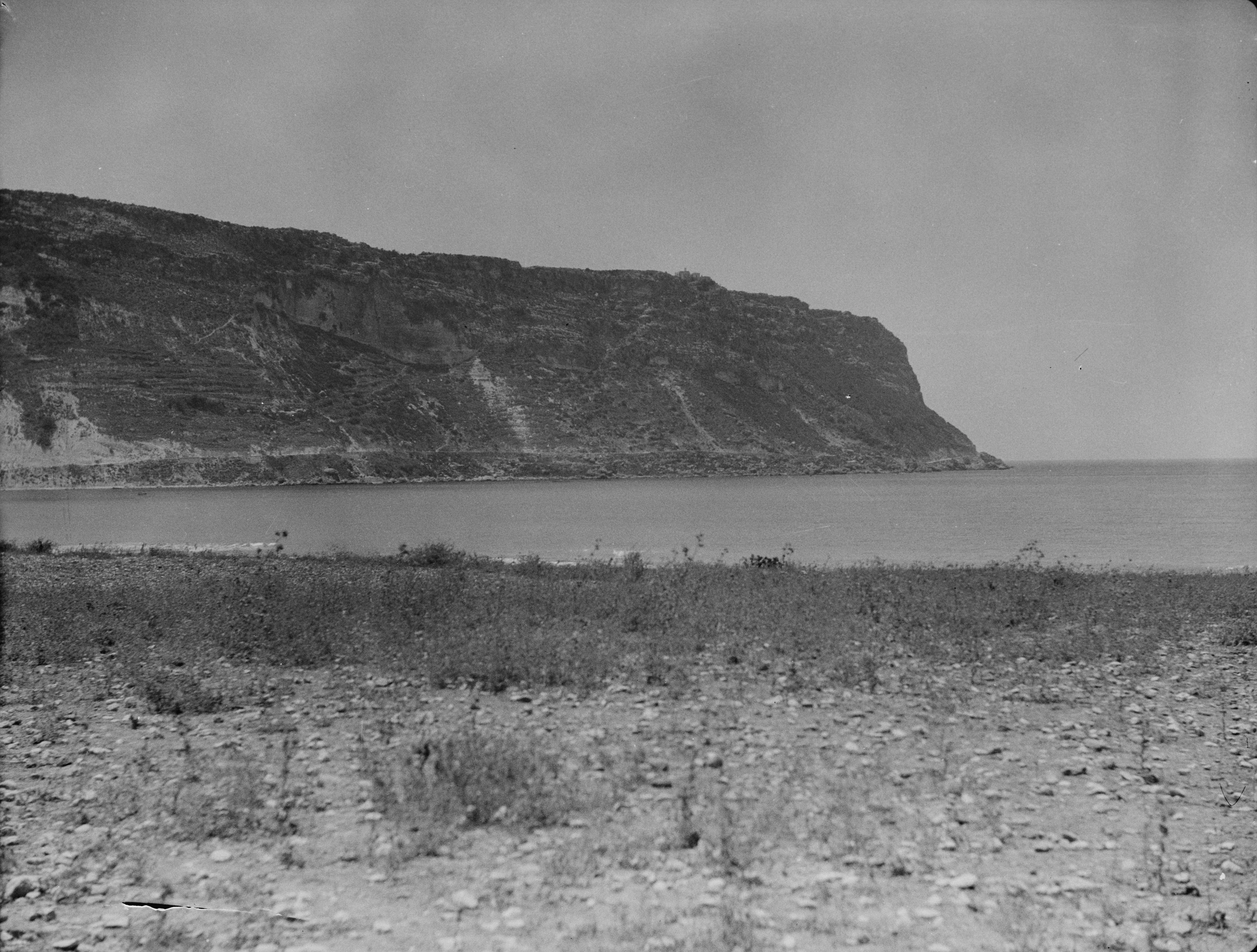
A black and white archival photograph showing a prominent coastal cliff or headland extending into the sea, with a rocky and sparsely vegetated shoreline in the foreground.
A historic view of the Ras ash-Shaq'a coastal promontory in Lebanon.

Ras ash-Shaq'a history and protected-area timeline

Ras ash-Shaq'a has been documented under different names by successive cultures that ruled or traveled along the eastern Mediterranean coast. The earliest known reference appears in the Greek Periplus attributed to Pseudo-Scylax, which refers to the promontory as "Theou Prosopon," meaning "Face of God." Ancient authors preserved this name, sometimes collapsing it into "Theuprosopon," establishing the cape as a recognizable landmark in classical maritime and geographic literature.

With the rise of the Byzantine Empire, the area became deeply Christianized, and the promontory's name shifted to Lithoprosopon, meaning "Face of Stone." Aramaic and Syriac historians translated this into Parsuph Kipa, and later Arab historians rendered it as Anf al-Hajar or Wajh al-Hajar, both meaning "Nose or Face of Stone." During the Crusades, European chroniclers referred to the cape as Puy du Connétable, or "Pew of the Constable," or "Mount of the General." Under Mamluk and Ottoman rule, the Arabic name Wajh al-Hajar regained prominence.

French travelers and historians added further naming layers. Laurent d'Arvieux wrote in 1660 that the Franks called the cape "Cape Rouge," likely a corruption of the Lebanese Arabic word wež, meaning "face." Jean de La Roque introduced two more names in 1688: Capo Pagro and Cappouge, with Cappouge probably a corruption of "Cap Rouge" or derived from "Capo poggio," meaning "Cape of the Hill." This matches the modern Arabic name Ras ash-Shaq'a, meaning "Cape of the Stone Monticule," a phrase thought to refer to the Greek Orthodox monastery of Our Lady of the Light, later known as Our Lady of Nourieh.

On the ground, the cape itself shaped historical movement along the coast. During antiquity, a road running parallel to the sea allowed travelers to circumvent Cape Lithoprosopon and connect Batroun to Tripoli. The earthquake of 551 A.D. reportedly caused a landslide that sank this road permanently beneath the sea, isolating Tripoli from Batroun and Byblos and reinforcing the promontory's role as a barrier to coastal travel for centuries. The modern coastal highway now cuts through the headland via two tunnels, finally overcoming the obstacle that defined the region for so long.

Ras ash-Shaq'a landscape and geographic character

Ras ash-Shaq'a's landscape is defined by the abrupt meeting of mountain geology and the Mediterranean Sea. The promontory projects outward from the Lebanese coast as a mass of high cliffs, forming a powerful headland that interrupts the shoreline between the historic cities of Batroun and Tripoli. The cliffs rise sharply above the water, creating a dramatic vertical face that has long been both a navigational reference and a physical barrier to movement along the coast.

The underlying terrain is rocky and steep, characteristic of northern Lebanon's coastal ranges where limestone formations meet the sea. The visual impression of the cape is one of stone mass: a wall-like landform that seems to grow directly out of the ocean. The slopes face the prevailing Mediterranean winds and sea spray, shaping a coastal environment that differs noticeably from the gentler shores to the north and south.

The Deir el Nouriyeh cliffs form part of this dramatic ensemble, contributing both to the visual identity of the promontory and to its ecological importance. The cliffs support a fragile interface between terrestrial and marine habitats, an environment that has been formally recognized through international wetland designation. Inland from the cape, the terrain transitions into the rolling landscapes of the surrounding Lebanese hill country, but the defining geological event of the region remains the headland's sudden projection into the sea.

Ras ash-Shaq'a ecosystems, habitats, and plant life

Ras ash-Shaq'a hosts an ecologically significant coastal environment where Mediterranean marine and cliff ecosystems meet. The cliffs of Deir el Nouriyeh support habitat types characteristic of the eastern Mediterranean coastline, including rocky cliff vegetation and wetland features that depend on the interaction of sea, rock, and seasonal conditions. This coastal interface, though limited in extent, is recognized for its ecological sensitivity and its role in supporting native coastal biodiversity.

The broader natural setting of the promontory is shaped by the same limestone-rich geology that defines much of northern Lebanon. Vegetation on and near the cliffs tends to be hardy and adapted to exposure, sea spray, and thin soils, while the surrounding inland areas carry the mixed Mediterranean flora typical of the Lebanese coast. The habitat gradients created by the steep cliffs create microenvironments that contrast with the lower-lying coastal plain.

The recognition of the Deir el Nouriyeh cliffs as a Ramsar site underlines the value of these habitats in a national context where coastal wetlands are limited and under pressure. Though the wet environment here is modest in scale, its ecological contribution and conservation importance are disproportionate to its size, placing it among Lebanon's recognized natural heritage sites.

Ras ash-Shaq'a wildlife and species highlights

Ras ash-Shaq'a's wildlife character is shaped by the rugged coastal cliffs and the proximity of the Mediterranean Sea. Cliff-nesting birds and seabirds typical of the eastern Mediterranean shoreline find habitat along the promontory's vertical faces, while the rocky shoreline below supports intertidal life typical of the Levantine coast. The surrounding terrestrial slopes and nearby inland habitats extend the range of species present, including reptiles, small mammals, and seasonal bird visitors that move along the Lebanese coast.

The Deir el Nouriyeh cliffs, recognized internationally as a Ramsar wetland, contribute specifically to the wildlife profile of the promontory. Such designations highlight the importance of the site's habitat for water-associated birdlife and other wetland-dependent fauna, even where the wetlands themselves are limited in extent. The cape thus plays a role both as a coastal wildlife habitat and as part of a broader network of protected natural areas along the Lebanese coast.

Ras ash-Shaq'a conservation status and protection priorities

Ras ash-Shaq'a carries significant conservation value through the international recognition of its cliffs as a Ramsar Wetland of International Importance. The Deir el Nouriyeh cliffs were designated on 16 April 1999, placing the promontory among a select group of Lebanese sites formally protected under international convention for their wetland characteristics. This recognition acknowledges the ecological sensitivity of the cliff and coastal environment and reflects broader concerns about the preservation of Lebanon's remaining natural coastal habitats.

The conservation importance of the site is amplified by its geographical position. The promontory is a defining feature of the northern Lebanese coast, and the habitats it supports contribute to regional ecological continuity between Batroun, Tripoli, and the wider Levantine shoreline. As coastal development pressures persist in Lebanon, the formal recognition of such sites underscores the value of maintaining buffer zones along cliffs and coastal wetlands.

Although the cape is widely known for its cultural and historical significance, its conservation profile derives primarily from its natural setting. The Ramsar designation provides both national and international frameworks for monitoring and protecting the cliffs, situating Ras ash-Shaq'a within the broader Mediterranean effort to safeguard vulnerable coastal ecosystems.

Ras ash-Shaq'a cultural meaning and human context

Ras ash-Shaq'a has carried deep cultural meaning for communities across the eastern Mediterranean. In antiquity, the promontory was revered as "Theou Prosopon," or "Face of God," a name that reflects the awe the headland inspired among ancient Greek travelers and writers. The shift to "Lithoprosopon" under the Byzantines marked not just a linguistic change but a cultural transformation, as Christian communities renamed the cape to align with their religious worldview, while still preserving its physical presence as a landmark.

The religious layer of the promontory remains active today. The Greek Orthodox Monastery of Our Lady of Nourieh, in the village of Hamat overlooking the cape, anchors a continuous Christian pilgrimage tradition. Believers travel to the monastery, and the cape itself has become associated with this religious heritage, blending architectural, monastic, and landscape identity into one cultural site.

The successive naming of the cape also reflects the layered political history of the region. Crusader chroniclers, Mamluk administrators, Ottoman officials, and French travelers each left linguistic traces on the promontory, marking it as a place where cultures met and overlaid one another. This naming history gives Ras ash-Shaq'a a rare depth of cultural memory for a single coastal feature.

Top sights and standout views in Ras ash-Shaq'a

Ras ash-Shaq'a combines dramatic coastal geology with centuries of cross-cultural history. The promontory's cliffs form one of northern Lebanon's defining coastal features, separating the historic cities of Batroun and Tripoli and shaping travel along the shore for millennia. Its Ramsar-recognized wetlands, ancient names like Theoprosopon and Lithoprosopon, and continuing role as a Christian pilgrimage site together make it a place where natural and cultural heritage intersect along the Mediterranean.

Best time to visit Ras ash-Shaq'a

Ras ash-Shaq'a is at its most inviting during the milder seasons of spring and autumn, when the Mediterranean climate of northern Lebanon produces comfortable temperatures for coastal viewing and pilgrimage walks. Summer brings warmer, brighter conditions suitable for seaside resort activity along the cape, while the cliffs and pilgrimage route to Our Lady of Nourieh remain accessible throughout much of the year. Winter conditions occasionally affect coastal visibility, but the headland's dramatic character persists across all seasons.
Monthly climate preview

Long-term representative coordinate records tracing monthly temperature and precipitation patterns

Ras ash-Shaq'a Climate Normals, Annual Temperature and Precipitation Rhythm

Ras ash-Shaq'a exhibits a measured annual thermal range spanning from mean monthly lows near 15.49 degrees Celsius to highs exceeding 30 degrees Celsius alongside distinct precipitation variations. Reviewing the complete twelve-month climatology dataset clarifies long-term meteorological trends across the coordinate point.
Annual mean21 °C
15 °C27 °C
Jan16°
Feb15°
Mar17°
Apr18°
May21°
Jun24°
Jul27°
Aug27°
Sep27°
Oct25°
Nov21°
Dec18°
Warmest month
August

27.3 °C

Coolest month
February

15.5 °C

Wettest month
January

4 mm/day

Driest month
July

0 mm/day

Park location guide

Geography guide, regional context, and park location map for Ras ash-Shaq'a

Ras ash-Shaq'a park geography, regions, and map view in Lebanon

Understand where Ras ash-Shaq'a sits in Lebanon through a broader geographic reading of the surrounding landscape, nearby location context, and its mapped position within the national park landscape.

How Ras ash-Shaq'a fits into Lebanon

Lebanon is a unitary parliamentary republic under confessionalism with a population of over 5 million. Located on the Mediterranean coast at the crossroads of ancient trade routes, it has a diverse religious composition with Islam and Christianity as the main faiths. The country has historical roots dating to Phoenicia and has been ruled by Romans, Byzantines, Ottoman Empire, and France.

Wider geography shaping Ras ash-Shaq'a in Lebanon

Lebanon is located in the Levant region of West Asia on the eastern Mediterranean coast. It is bordered by Syria to the north and east, Israel to the south, and the Mediterranean Sea to the west. The country has a small territory of 10,452 square kilometres, with a narrow coastal plain and mountainous interior including the Lebanon Mountains.

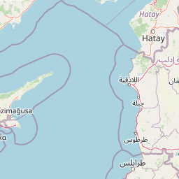
Map view of Ras ash-Shaq'a

Use this park location map to pinpoint Ras ash-Shaq'a in Lebanon, understand its exact geographic position, and read its mapped placement within the surrounding landscape more clearly.

Pigeon | © OpenStreetMap contributors

Visualizing the rugged limestone cliffs, marine habitats, and protected terrain of the Mediterranean promontory

Ras ash-Shaq-a Photos and Scenery: Exploring the Dramatic Coastal Landscapes of Northern Lebanon

Examine detailed park photography showcasing the vertical stone walls, cliffside refuge zones, and dramatic Mediterranean meeting points that define the geography of Ras ash-Shaq-a. Visual reference material provides deeper context into the steep terrain, coastal habitats, and protected character of the historic Lebanese headland.

A black and white archival photograph showing a prominent coastal cliff or headland extending into the sea, with a rocky and sparsely vegetated shoreline in the foreground.

Park atlas

Compare coastal promontories, cliff habitats, and adjacent Mediterranean landscapes.

Exploring Parks Near Ras ash-Shaq'a and Protected Areas in the Surrounding Region

Browse protected areas and coastal reserves situated near Ras ash-Shaq'a to analyze regional limestone formations and marine habitats. Extending geographic comparison across northern Lebanon reveals broader patterns in Mediterranean coastal geography.
Nature reserveLebanon
About 22 km away#1 closest

North

Palm Islands Nature Reserve: A Protected Lebanese Nature Reserve with Critical Marine Habitats

Discover the island geography and mapped protected area.

Palm Islands Nature Reserve encompasses three flat, rocky limestone islands off the coast of northern Lebanon. This vital nature reserve, recognized internationally as a Ramsar site and Mediterranean Specially Protected Area, serves as a critical habitat for endangered green sea turtles and Mediterranean monk seals. Its unique coastal landscape and surrounding waters offer essential resting grounds for migratory birds, making it a significant point in the regional atlas of protected lands.

Area
4.2 km²
Established
1992
Relief
Lowland
Climate
Mediterranean
Nature reserveNorth Lebanon Governorate
About 24 km away#2 closest

Southeast

Tannourine Cedar Forest Nature Reserve: A Premier Protected Cedar Landscape in North Lebanon

Mapped geography of Lebanon's largest cedar forest.

Delve into the Tannourine Cedar Forest Nature Reserve, a protected area critically important for its extensive cedar groves within the North Lebanon Governorate. This nature reserve encompasses a complex mountain geography characterized by deep ravines, imposing cliffs, and secluded caves, providing a dramatic backdrop for its dominant cedar population. Users can explore the mapped boundaries and understand the regional landscape context of this ecologically significant coniferous forest, essential for Lebanon's natural atlas.

Area
1.955 km²
Established
1999
IUCN
IV
Relief
Mountain
Protected areaLebanon
About 25 km away#3 closest

East

Ouadi Qadisha Protected Area: Explore Lebanon's Mapped Natural Landscapes and Geographic Boundaries

Discover the protected terrain and regional setting of Ouadi Qadisha.

Ouadi Qadisha stands as a key protected area, offering a focused lens on Lebanon's natural geography and protected landscapes. Through this entry, users can investigate the park's specific mapped boundaries, its regional terrain, and its importance within the atlas of natural areas. The structured data available here supports detailed exploration of the protected landscape's geographic context, distinguishing it within the Levant's diverse natural regions.

Relief
Mountain
Scope
Mixed
Water
Minor water
Nature reserveLebanon
About 27 km away#4 closest

East

Horsh Ehden Nature Reserve: Protected Nature Reserve within Lebanon's Regional Geography

Explore mapped protected land and natural terrain.

Horsh Ehden Nature Reserve is identified as a critical protected area within Lebanon. This page facilitates an atlas-style exploration of the reserve's specific geographic footprint, highlighting its mapped boundaries and the distinct natural terrain it preserves. Understanding Horsh Ehden Nature Reserve's role as a nature reserve contributes to a broader appreciation of protected landscapes and their regional context.

Area
17.4 km²
Established
1992
IUCN
Ib
Relief
Mountain
Nature reserveKeserwan District
About 29 km away#5 closest

South

Jabal Moussa Biosphere Reserve: Lebanon's Protected Nature Reserve with Distinct Geographic Identity

Mapped protected landscape within Keserwan District's regional geography.

Jabal Moussa Biosphere Reserve represents a crucial protected area in Lebanon, defined by its unique natural landscape and mapped boundaries. Positioned within the Keserwan District, this nature reserve offers valuable insights for geographic exploration and understanding protected land distribution. Its inclusion in the MoriAtlas platform highlights its significance for regional conservation and atlas-style discovery of Lebanon's natural terrain.

Area
65 km²
Established
2009
Relief
Mountain
Climate
Mediterranean
Nature reserveBaalbek-Hermel Governorate
About 36 km away#6 closest

Southeast

Yammoune Nature Reserve: Mapped Geography and Protected Area Context in Lebanon

High altitude mountain lake and juniper forest landscapes

Yammoune Nature Reserve offers a comprehensive look at the high northern Beqaa Valley through its rare juniper-covered uplands and unique freshwater ecosystem. The reserve hosts the only habitat for Lebanon's endemic fish, set against a backdrop of ancient Roman ruins and active geological fault lines that define the regional mountain terrain.

Established
1998
Relief
Upland
Climate
Mediterranean
Access
Access unknown
Biosphere reserveLebanon
About 65 km away#7 closest

South

Aammiq Wetland Biosphere Reserve: Mapping Lebanon's Crucial Freshwater Protected Landscape

Discover its geography, mapped terrain, and role as a biodiversity hotspot.

Aammiq Wetland is Lebanon's most significant freshwater protected area, recognized as a UNESCO Biosphere Reserve and Ramsar site. Its unique geography, characterized by extensive reedbeds and open pools fed by mountain snowmelt, makes it a vital stopover for countless migratory bird species traversing the Middle East. This protected landscape offers rich opportunities for atlas-style exploration, revealing the ecological importance of its mapped terrain and its role as a critical biodiversity hotspot.

Area
2.53 km²
Established
1999
IUCN
IV
Relief
Lowland
Nature reserveLebanon
About 69 km away#8 closest

South

Al Shouf Cedar Nature Reserve: A Protected Landscape in Lebanon's Geography

Explore its mapped natural terrain and protected boundaries.

Investigate Al Shouf Cedar Nature Reserve, a protected natural area situated within Lebanon. This page offers a detailed view of its protected landscape identity and geographic context, crucial for understanding its placement within the region's natural atlas. Examine the mapped terrain and park boundaries that distinguish this significant nature reserve.

Area
550 km²
Established
1996
Relief
Mountain
Climate
Temperate

Common questions about visiting, size, designation, and location context for Ras ash-Shaq'a

Ras ash-Shaq'a FAQs for park facts, access, geography, and protected area context

Find quick answers about Ras ash-Shaq'a, including protected-area facts, park geography, trail and visitor context, and how the park fits into its surrounding country and regional landscape.
MoriAtlas Explorer

Continue Your Protected Areas Search Across the Global Atlas

Deepen your exploration by continuing the structured search for national parks and protected areas worldwide. Utilize the comprehensive filtering capabilities to compare different conservation landscapes and refine your understanding of global park geography. Discover more about the distribution and characteristics of protected natural areas.

Global natural geography