Mori Atlas logo
Wildlife reserveReserva Biológica Limoncocha

Understanding the hydrologic terrain and floodplain ecosystems of a critical Amazonian wildlife reserve.

Reserva Biológica Limoncocha: Mapped Geography and Protected Wetland Landscapes in Ecuador

Reserva Biológica Limoncocha protects a unique mosaic of tropical aquatic environments within the Sucumbíos province of the Ecuadorian Amazon. This wildlife reserve features a complex network of lagoons, including Laguna de Limoncocha and Yanacocha, surrounded by seasonally flooded várzea and igapó palm forests. The landscape serves as an essential ecological corridor shaped by ancient river meanders, supporting distinct terra firme plateaus and high-density wetland habitats.

Amazon rainforestwetland reserveRamsar sitelacustrine ecosystemsblack caiman habitatbirdwatching

Reserva Biológica Limoncocha

Wildlife reserve

Park overview

Structured park overview, official facts, and landscape profile for Reserva Biológica Limoncocha

Reserva Biológica Limoncocha park facts, protected area profile, and essential visitor context

Review the core facts for Reserva Biológica Limoncocha, including designation, size, terrain, visitor scale, habitats, and operating context in one park-focused overview.

About Reserva Biológica Limoncocha

Reserva Biológica Limoncocha is a small but intensively protected biological reserve in Ecuador's northern Amazon, about 70 kilometers southeast of the regional city of Nueva Loja (also known as Lago Agrio). Although limited in geographic extent compared with better-known neighbors such as Cuyabeno and Yasuní, Limoncocha has a distinct identity: it is essentially a wetland reserve, with its entire territory overlapping the hydrological footprint of Limoncocha Lagoon and the broader floodplains that feed into the Río Napo.

The reserve encompasses two main types of tropical rainforest. To the north lies terra firme or plateau forest, on terrain about 15 to 20 meters above the level of the lagoon, where the ground is not normally flooded. To the south and west of the lagoon, lower forests and palm swamps dominate, inundated for several months each year during the high-water season from January through May. These lowland flooded forests resemble classic várzea and igapó formations of the Amazon basin, with extensive moretales, or palm swamps dominated by morete palms. In some places the floodplain preserves sandy ridges that may once have been meander bars of the ancient Río Napo, today forming elevated substrate preferred by nesting caimans.

The hydrology of Limoncocha is central to its ecological identity. The reserve sits largely within the watershed of the Río Capucuy, whose tributaries include the Playayacu, Pichira, Blanco, and Piñasyacu. The Capucuy, Jivino, and Indillana rivers flow upstream into the Río Napo when the main river is high, while the Jivino and Itaya drain large areas in the northern part of the reserve year-round. The interconnected mosaic of lagoons, rivers, flooded forest, and plateau forest creates habitat heterogeneity that supports an unusually complete cross-section of Amazonian wildlife for an area of its size.

The reserve's biological significance was formally recognized in 1998 when UNESCO designated it as a Ramsar site for the conservation of wetlands. Together with the Yasuní and Cuyabeno regions, Limoncocha anchors a network of Amazonian protected areas in Sucumbíos and neighboring provinces that is widely regarded as among the highest-priority conservation landscapes in the western Amazon.

Quick facts and research context for Reserva Biológica Limoncocha

Reserva Biológica Limoncocha lies in the northeastern Ecuadorian Amazon, in the Sucumbíos province, within the Shushufindi canton. Ecuador's Ministry of the Environment administers it as a biological reserve, a category with stricter protection than a national park in practical management terms. The reserve was created on 23 September 1985 and covers just under 4,000 hectares, placing it among the smaller but intensively protected Amazonian reserves of the country.

It belongs to the Amazonian ecoregion within the Neotropical realm and contains a Ramsar-listed wetland designated in 1998. Its centerpieces are Laguna de Limoncocha, historically known as Capucuy, and Laguna Negra or Yanacocha, along with rivers such as the Capucuy, Jivino, Indillana, and Itaya that connect into the Río Napo, one of the major tributaries of the Amazon basin.

Protection and recognition

Documented terrestrial protection history, management scope, and Ramsar site listing details

Reserva Biológica Limoncocha Protection Status and International Recognition

Reserva Biológica Limoncocha holds documented terrestrial protection status established in 1998 alongside official Ramsar wetland recognition. Structured records outline the historical designation timeline and international recognition sources for the protected area.

International recognition

Protection details

Protection scope
Terrestrial
Designated year
1998
Transboundary protection
No
Park context

Deeper park guide and search-rich context for Reserva Biológica Limoncocha

Reserva Biológica Limoncocha history, landscape, wildlife, and travel context

Explore Reserva Biológica Limoncocha through its history, landscape character, ecosystems, wildlife, conservation priorities, cultural context, and seasonal travel timing in a structured park guide built for atlas discovery and search intent.

Why Reserva Biológica Limoncocha stands out

Limoncocha is best known as a compact Ramsar wetland reserve in the Ecuadorian Amazon, defined by its Laguna de Limoncocha and surrounding floodplain ecosystems. Its flooded palm forests, especially the moretales dominated by Mauritia flexuosa palms, and its interconnected lagoon and river system give the reserve a distinctive wetland character unusual even within Amazonia. The reserve is also well known for its role in protecting black caiman habitat and for supporting an exceptionally varied amphibian fauna, with the broader northern Oriente of Ecuador long recognized as one of the world's richest zones for frogs and toads. Birdwatchers value it for its 300-plus recorded bird species, including threatened species such as the horned screamer and the mangrove black hawk, and Ecuador's endemic Ecuadorian cacique.
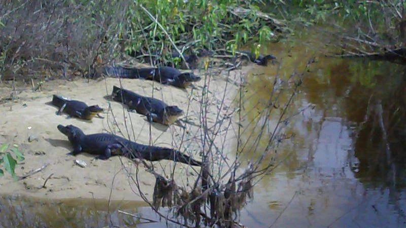
Four dark-colored black caimans resting on a small sandy beach at the edge of a murky brown river with surrounding green vegetation.
A group of black caimans resting on a sandy riverbank in the Amazon basin.

Reserva Biológica Limoncocha history and protected-area timeline

Reserva Biológica Limoncocha was formally established on 23 September 1985 through Interministerial Agreement No. 0394, published in Ecuador's Official Register on 1 October 1985. Its creation responded to growing awareness of the conservation value of the Limoncocha lagoon system and surrounding wetlands, which were already recognized locally as an exceptional natural area within Ecuador's northern Oriente.

In 1998, the reserve gained international recognition when its entire territory was inscribed as a Ramsar site by UNESCO, reflecting both its ecological importance and the global interest in Amazonian wetlands. The Ramsar designation reinforced existing national protections rather than replacing them, and the reserve continues to be administered by Ecuador's Ministry of the Environment.

Throughout its history, Limoncocha has coexisted with surrounding land uses, particularly oil exploration and small-scale agriculture in nearby Shushufindi. Past petroleum exploration has left visible traces on parts of the forest, where secondary vegetation, including balsa and guarumo trees, now grows after earlier clearing. Conservation efforts in recent decades have focused on managing these impacts while ensuring that the lagoons, flooded forests, and core wildlife populations remain viable.

Reserva Biológica Limoncocha landscape and geographic character

The landscape of Limoncocha is defined by water, gentle relief, and the interplay between flooded and unflooded terrain. The center is the Laguna de Limoncocha itself, historically called Capucuy, a shallow lagoon that fluctuates with the seasons and is connected to the Río Napo. North of this lagoon lies a low plateau, only about 15 to 20 meters above the water level, which supports taller, unflooded tropical rainforest. South and west of the lagoon, the land drops into permanently or seasonally inundated forest and palm swamp, where the water table remains at or near the surface throughout much of the year.

The reserve contains several other important water bodies besides Laguna de Limoncocha. Laguna Negra, also known as Yanacocha, lies within the reserve and is surrounded by igapó forest dominated by chontilla palms and associated macrolobio trees. A network of small rivers and streams drains the reserve, including the Capucuy, Jivino, Indillana, and Itaya, whose courses shift between dry-season flow and high-season flooding. The resulting landscape is a patchwork of open water, floating and emergent vegetation, flooded palm forest, and elevated dry forest that varies dramatically with the rise and fall of the Napo system.

Geologically, the lagoon basins are believed to be ancient meanders of the Río Napo, formed over time as the river carried large quantities of sediment from the western Andean foothills. Today, the surrounding floodplain preserves features that may once have been sandy river bars, now lightly elevated ridges above the swamp where certain animals, including caimans, prefer to nest.

Reserva Biológica Limoncocha ecosystems, habitats, and plant life

Limoncocha's vegetation reflects its mosaic of dry and flooded habitats. In unflooded plateau forest to the north, the canopy resembles that of nearby Cuyabeno and Yasuní, with tall emergent trees, a rich understory of palms such as chambira (Astrocaryum urostachys), pambil, ratama, and ungurahua (Oenocarpus bataua), plus abundant bromeliads, orchids, mosses, and giant ferns. Where past clearing associated with oil exploration has occurred, secondary forest species such as balsa (Ochroma pyramidale) and guarumo (Cecropia) now dominate.

In the flooded south and west, vegetation transitions into characteristic Amazonian wetland formations. In the igapó around Limoncocha and in Laguna Negra, chontilla palms (Bactris species) dominate, often associated with macrolobio trees. The moretales, palm swamps in which morete or buriti palms (Mauritia flexuosa) form vast nearly monocultural stands, cover permanently inundated zones, particularly at the southern end of the reserve. Climbing vines such as uña de gato (Uncaria tomentosa) intertwine through these wetland forests. In well-developed secondary flooded forest, large individuals of ceiba (Ceiba pentandra) and cedar (Cedrela odorata) rise above the general canopy.

The wetland character of the reserve, declared a Ramsar site in 1998, is fundamental to its ecological identity. Limoncocha's combination of permanent lagoons, seasonal flooding, and connected floodplain forests creates habitat gradients that support a particularly complete sample of aquatic and semi-aquatic life for an Amazonian reserve of its size.

Reserva Biológica Limoncocha wildlife and species highlights

Wildlife at Limoncocha is exceptionally varied, even though individual species often occur at relatively low densities. At least 53 mammal species, 92 reptile species, and 292 amphibian species have been recorded within or around the reserve. The broader northern Amazonian region of Ecuador has been described in scientific literature as one of the most amphibian-rich zones on Earth, and Limoncocha lies squarely within this area of high frog and toad diversity.

Among reptiles, the black caiman (Melanosuchus niger) is one of the reserve's most iconic species, using shoreline sandy ridges and quiet lagoon stretches for basking and nesting. The large aquatic turtle locally known as charapa (Podocnemis expansa) is also commonly encountered, along with the smaller motelo tortoise and occasional boas and other snakes.

Mammals in the reserve include several primate species, such as woolly monkeys (Lagothrix lagotricha), red howler monkeys (Alouatta seniculus), pygmy marmosets (Cebuella pygmaea), night monkeys (Aotus vociferans), capuchins (Cebus albifrons), and spider monkeys. Other mammals recorded within the reserve include ocelots, three-toed sloths, agoutis, and capybaras, particularly in and around the wetland habitats.

Birdlife is one of Limoncocha's main attractions. More than 300 bird species have been recorded historically, including rare and threatened species such as the horned screamer (Anhima cornuta) and the mangrove black hawk (Buteogallus anthracinus), as well as the Ecuadorian cacique (Cacicus sclateri), a species endemic to Ecuador. Aquatic habitats also harbor a range of fish, including electric fish, piranha species, and several types of catfish.

Reserva Biológica Limoncocha conservation status and protection priorities

Conservation significance is central to Limoncocha's identity. Although it is relatively small in area, the reserve is among the most intensively protected wetland sites in Ecuador, and its ecological importance is recognized through both national and international designations. It is administered as a biological reserve by Ecuador's Ministry of the Environment, a category that implies more restrictive management than less strictly protected area types.

The most important international recognition came in 1998, when the entire area was inscribed as a Ramsar site under the Convention on Wetlands of International Importance. This designation highlighted the lagoon system and its associated flooded forests as critical habitat for waterbirds, fish, caimans, and other wetland-dependent wildlife, and placed Limoncocha within a global network of priority wetland conservation sites.

The reserve also plays an important role within a broader network of Amazonian protected areas in Sucumbíos, alongside Yasuní to the south and Cuyabeno to the northeast. Together these reserves protect a substantial portion of the Ecuadorian Amazon's biodiversity, including many of its most intact forest and wetland systems. Ongoing challenges in the region include pressures from oil exploration and selective logging near the reserve's boundaries, making Limoncocha's strict protection status and Ramsar recognition especially important for long-term conservation.

Reserva Biológica Limoncocha cultural meaning and human context

Limoncocha lies within the broader historical and cultural setting of the northern Ecuadorian Amazon, an area historically inhabited by indigenous peoples of the Amazon basin and later drawn into national economic and settlement patterns. The lagoon has long been a focal point of the local landscape, and its original name, Capucuy, points to a heritage linked to indigenous knowledge of the region's hydrology and ecology.

The modern cultural context is shaped by the development of the Shushufindi canton, where oil extraction has been one of the dominant economic activities for several decades. This has brought roads, settlements, and migration into the area surrounding the reserve, while Limoncocha itself remains a place where Amazonian wildlife, flooded forests, and traditional ecological relationships survive close to inhabited zones. Visits to Limoncocha often connect to broader Amazonian cultural experiences in the Sucumbíos region, including indigenous community tourism and wildlife-focused lodges such as nearby Cuyabeno.

Top sights and standout views in Reserva Biológica Limoncocha

Reserva Biológica Limoncocha stands out for being an almost entirely wetland-based protected area, with its lagoons, rivers, and flooded forests at the heart of its identity. Its Ramsar status underscores international recognition of the ecological importance of these waters, and its compact size makes the reserve unusually accessible compared with many larger Amazonian parks.

The reserve's combination of black caiman populations, exceptionally rich amphibian fauna, hundreds of bird species, and intact Amazonian primate communities makes it a disproportionately rich site for wildlife observation. Its mosaic of terra firme forest, igapó, and moretales habitats, all within a few kilometers of each other, gives visitors a concentrated experience of Amazonian ecological diversity.

Best time to visit Reserva Biológica Limoncocha

Seasonality at Limoncocha is governed primarily by the rise and fall of the Río Napo and the rainfall patterns in the upper Napo basin, including the Payamino, Napo, and Coca catchments. Water levels in Laguna de Limoncocha are highest during the rainy season and the period of highest river discharge, generally from January through May, when large areas to the south and west of the lagoon are flooded.

Visiting during the drier months, when water levels recede and trails and lagoon edges become more accessible, often offers easier wildlife viewing along the lake shores and forest paths. Wetter months bring higher water levels, broader flooding, and different wildlife concentrations, with fish and aquatic species especially active. Climate is consistently hot and humid year-round, as is typical of the lowland Ecuadorian Amazon.

Monthly climate preview

Long-term monthly temperature averages and precipitation patterns for Sucumbíos

Reserva Biológica Limoncocha Climate Normals, Annual Temperature, and Precipitation Rhythm

Representative coordinate measurements reveal the annual temperature and precipitation rhythm across twelve months at Reserva Biológica Limoncocha. Reviewing complete monthly climate normals provides deeper context on measured averages without relying on live forecasts.
Annual mean25 °C
23 °C25 °C
Jan25°
Feb25°
Mar25°
Apr25°
May24°
Jun24°
Jul23°
Aug24°
Sep25°
Oct25°
Nov25°
Dec25°
Warmest month
February

25.4 °C

Coolest month
July

23.5 °C

Wettest month
May

7.7 mm/day

Driest month
August

4.6 mm/day

Park location guide

Geography guide, regional context, and park location map for Reserva Biológica Limoncocha

Reserva Biológica Limoncocha park geography, regions, and map view in Ecuador

Understand where Reserva Biológica Limoncocha sits in Ecuador through a broader geographic reading of the surrounding landscape, nearby location context, and its mapped position within the national park landscape.

How Reserva Biológica Limoncocha fits into Ecuador

Ecuador is a presidential republic located in northwestern South America, with Quito as its capital and Guayaquil as its largest city. The country spans 283,561 km² and encompasses the Galápagos Islands, a volcanic archipelago famous for unique wildlife that helped shape Darwin's theory of evolution. Ecuador is a plurinational state with Spanish as the official language, though Kichwa and Shuar are recognized for indigenous peoples.

Wider geography shaping Reserva Biológica Limoncocha in Ecuador

Ecuador is located in northwestern South America along the Pacific coast. It shares borders with Colombia to the north and Peru to the east and south. The country includes the Galápagos Islands, a volcanic archipelago in the Pacific Ocean approximately 1,000 km west of the mainland. The territory encompasses diverse terrain including the Amazon rainforest in the east, the Andean highlands in the center, and coastal plains along the Pacific.

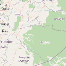
Map view of Reserva Biológica Limoncocha

Use this park location map to pinpoint Reserva Biológica Limoncocha in Ecuador, understand its exact geographic position, and read its mapped placement within the surrounding landscape more clearly.

Pigeon | © OpenStreetMap contributors

Location context for Reserva Biológica Limoncocha

Sucumbíos
Recorded earthquake history

View Recorded Earthquake History Near Reserva Biológica Limoncocha

Access a structured collection of historical seismic records documented within the vicinity of the reserve. This MoriAtlas catalogue provides a clear mapping of regional earthquake events in the Sucumbíos province to assist with geographic study.

Reserva Biológica Limoncocha Earthquake History

Catalogued events

2 events

Strongest magnitude

Magnitude 4

Most recent event

Apr 29, 2016

This history includes earthquakes recorded inside the park or within 50 km of its borders

Visual reference for the protected rainforest, lagoons, and flooded palm swamps

Reserva Biológica Limoncocha Photos, Scenery, and Wetland Landscapes

Visual documentation captures the complex mosaic of open water, flooded palm forests, and raised terra firme terrain defining the protected ecosystem. Examining detailed imagery reveals the distinct geography, seasonal wetland dynamics, and habitat structure unique to the reserve.

Four dark-colored black caimans resting on a small sandy beach at the edge of a murky brown river with surrounding green vegetation.

Park atlas

Compare regional wetland reserves and connected tropical forest habitats in the Ecuadorian Amazon.

Parks Near Reserva Biológica Limoncocha and Surrounding Protected Landscapes

Browse other parks near Reserva Biológica Limoncocha to examine matching wetland ecosystems and flooded forest terrain. Extending the search across the surrounding region reveals broader patterns in tropical conservation and regional geography.
National parkEcuador
5.2 km away#1 closest

Southeast

Yasuní National Park: Ecuador's Protected Landscape and Geographic Atlas Entry

Explore the mapped boundaries and regional terrain of this key national park.

Delve into the atlas-level details of Yasuní National Park, Ecuador's designated national park. This entry provides essential geographic context, focusing on the park's mapped boundaries and its role as a protected landscape within the region. Understand the specific terrain and protected area distribution that makes Yasuní National Park a significant point of geographic interest for atlas exploration.

Area
10,227.4 km²
Established
1979
IUCN
II
Relief
Lowland
Wildlife reserveSucumbíos
29 km away#2 closest

East

Reserva de Producción de Fauna Cuyabeno: Geography of an Amazonian Wildlife Reserve

Explore protected boundaries and flooded landscape patterns in Sucumbíos

Reserva de Producción de Fauna Cuyabeno serves as a benchmark for Amazonian conservation, characterized by its extraordinary hydrological dynamics. The landscape comprises a network of blackwater rivers and semi-permanent lagoons that sustain an immense variety of species. As a protected area within Sucumbíos, it showcases the intricate relationship between seasonally submerged forests, terra firme terrain, and the vital river arteries that define this region.

Area
5,901.12 km²
Established
1979
IUCN
VI
Visitors
12K annual
National parkEcuador
71 km away#3 closest

West

Sumaco Napo-Galeras National Park: Ecuador's Volcanic National Park Landscape

Explore protected areas and biodiversity in the Andean-Amazon transition.

Sumaco Napo-Galeras National Park protects a dramatic volcanic landscape in Ecuador, showcasing a significant elevation gradient that supports diverse cloud forest and Amazonian rainforest habitats. This national park is recognized for its endemic species and rich avifauna, offering a compelling case study for understanding protected land geography and ecological transitions within South America.

Area
2,067.49 km²
Established
1994
IUCN
II
Relief
Mountain
Nature reserveSucumbíos
92 km away#4 closest

Northwest

Reserva Ecológica Cofán-Bermejo: Mapping Amazonian and Andean Biodiversity Landscapes

Indigenous-led conservation in the Sucumbíos river headwaters.

Reserva Ecológica Cofán-Bermejo encompasses a remarkable altitudinal range from 400 to 2,200 meters, protecting intact river basins and transitional ecosystems. This nature reserve offers deep insight into the convergence of Amazonian and Andean flora, functioning as a vital refuge for threatened megafauna and rare bird populations within an indigenous-managed territory.

Area
549.47 km²
Established
2002
IUCN
Ia
Relief
Mountain
National parkPeru
107 km away#5 closest

East

Güeppi-Sekime National Park: Protected National Park Atlas in Peru

Mapped landscape and regional geography of this Amazonian protected area.

Güeppi-Sekime National Park is a prominent protected area in Peru, recognized as a national park safeguarding a substantial expanse of tropical forest. Its landscape is characterized by diverse terrain, including rolling hills and seasonally inundated lowlands, vital for a rich tapestry of flora and fauna. The park's strategic location on the Ecuador border underscores its importance for transboundary conservation and ecological connectivity within the western Amazon basin. This page offers detailed information on its protected area identity, geographic context, and the mapped natural features that define this significant conservation landscape.

Area
2,036 km²
Established
2012
IUCN
II
Relief
Mixed relief
Watercolor illustration of a winding path through a green landscape with snow capped mountains in the distance against a pink sky.
National parkNapo
133 km away#6 closest

West

Parque nacional Antisana: Volcanic Terrain and Andean Protected Area Geography

High-altitude ecosystems spanning Napo and the Andean corridor

Spanning the rugged Cordillera Real, Parque nacional Antisana protects a vast sweep of volcanic terrain dominated by its central stratovolcano. From glacial fields to the water-retention capacity of its páramo wetlands, the area represents a crucial node in Ecuador's conservation network, providing a sanctuary for Andean condors and diverse montane species.

Area
1,205.81 km²
Established
1993
IUCN
Ia
Relief
Mountain
Protected areaColombia
About 136 km away#7 closest

North

Santuario Orito Indí-Andé Fauna and Flora Sanctuary: A Protected Area's Geographic and Landscape Identity in Colombia

Explore mapped boundaries and regional natural terrain context.

Gain insight into Santuario Orito Indí-Andé Fauna and Flora Sanctuary, a vital protected area contributing to Colombia's conservation landscape. This entry focuses on its distinct geographic characteristics and mapped territory. Understand the park's place within the national atlas and its contribution to regional geographic knowledge. It provides a structured foundation for exploring the natural terrain and protected boundaries specific to this important Colombian sanctuary.

Area
1,020 km²
Established
2008
Relief
Mountain
Access
Access unknown
A horizontal watercolor painting depicting a purple mountain range in the background behind soft green rolling hills and a stream in the foreground.
National parkEcuador
About 138 km away#8 closest

West

Parque nacional Cayambe-Coca: Regional Geography and Protected Landscape Analysis

Equatorial volcanic peaks and Amazonian slope geography

Examine the physical geography of Parque nacional Cayambe-Coca, a protected area in Ecuador known for its extreme elevation shifts. The mapped terrain transitions from the glaciated summit of Volcán Cayambe through extensive páramo wetlands and montane cloud forests into the Amazonian foothills, providing a comprehensive case study of Andean environmental gradients.

Area
4,031.03 km²
Established
1970
IUCN
II
Relief
Mountain

Common questions about visiting, size, designation, and location context for Reserva Biológica Limoncocha

Reserva Biológica Limoncocha FAQs for park facts, access, geography, and protected area context

Find quick answers about Reserva Biológica Limoncocha, including protected-area facts, park geography, trail and visitor context, and how the park fits into its surrounding country and regional landscape.
MoriAtlas Explorer

Continue Your Protected Areas Search Across the Global Atlas

Deepen your exploration by continuing the structured search for national parks and protected areas worldwide. Utilize the comprehensive filtering capabilities to compare different conservation landscapes and refine your understanding of global park geography. Discover more about the distribution and characteristics of protected natural areas.

Global natural geography