Mori Atlas logo
Nature reserveReserva Ecológica Cofán-Bermejo

Explore the dramatic altitudinal gradients and river headwaters of this protected nature reserve in Sucumbíos.

Reserva Ecológica Cofán-Bermejo: Mapping a Pristine Transition from Amazon Rainforest to Andean Peaks

Reserva Ecológica Cofán-Bermejo represents a unique ecological corridor in northeastern Ecuador where lowland Amazonian rainforest transitions rapidly into montane cloud forest and high-elevation páramo. This nature reserve, administered by the indigenous Cofán people, protects the upper reaches of the Bermejo and Chandia Na'en river basins. Its vast terrain serves as a critical habitat for threatened Andean species, offering an undisturbed vertical landscape for ecological research and conservation analysis.

indigenous-led conservationAmazon rainforestAndean cloud forestpáramoIUCN Category IaImportant Bird Area

Reserva Ecológica Cofán-Bermejo

Nature reserve

Park overview

Structured park overview, official facts, and landscape profile for Reserva Ecológica Cofán-Bermejo

Reserva Ecológica Cofán-Bermejo park facts, protected area profile, and essential visitor context

Review the core facts for Reserva Ecológica Cofán-Bermejo, including designation, size, terrain, visitor scale, habitats, and operating context in one park-focused overview.

About Reserva Ecológica Cofán-Bermejo

Reserva Ecológica Cofán-Bermejo stands as one of Ecuador's most ecologically significant and culturally distinctive protected areas. Situated in the far northeast of the country in Sucumbíos Province, the reserve forms part of the upper Amazon watershed in the Bermejo river system, straddling the international border with Colombia along the San Miguel River. Its location at the meeting point of the Andes and the Amazon gives it a geological and ecological character found in very few places on Earth.

The protected landscape encompasses an elevational gradient of roughly 1,800 meters, from lowland river valleys at about 400 meters above sea level to the high ridges and summits approaching 2,200 meters on and around Cerro Sur Pax. This dramatic vertical range produces a layered series of forest types: lowland evergreen rainforest along the rivers and lower slopes, montane and cloud forests at middle elevations, and elfin forest and páramo vegetation near the highest peaks. The result is a mosaic of habitats that supports an exceptional concentration of species.

Most of the reserve remains in a practically pristine condition, with extensive tracts of undisturbed forest. The few inhabited areas are managed by the indigenous Cofán communities of Sinangoe, who continue traditional subsistence practices including small-scale agriculture, hunting, and fishing in carefully maintained cultural landscapes. The reserve was formally established in 2002, but its protection is rooted in the long-standing stewardship of the Cofán people, whose ancestral territory the reserve protects.

Cofán-Bermejo is internationally recognized as both an IUCN Category Ia strict nature reserve and an Important Bird and Biodiversity Area under the BirdLife International framework. Its combination of indigenous governance, scientific importance, and largely untouched ecosystems places it among the most noteworthy conservation models in the Amazon region.

Quick facts and research context for Reserva Ecológica Cofán-Bermejo

Reserva Ecológica Cofán-Bermejo was officially created on January 30, 2002 through Ministerial Agreement No. 16, registered in the Official Gazette on February 21, 2002. It is classified as an IUCN Category Ia strict nature reserve, the most restrictive protection category, and is recognized internationally as an Important Bird and Biodiversity Area (IBA).

The reserve spans roughly 55,000 hectares in Sucumbíos Province within the Napo moist forest ecoregion of the western Amazon. Its elevation ranges from about 400 meters in the lowland river valleys to approximately 2,200 meters on the slopes of the mountainous terrain near the Colombian border. Administration is carried out by the Cofán communities of Sinangoe through the Federación Indígena de la Nacionalidad Cofán del Ecuador (FEINCE) and the Foundation for the Survival of the Cofán People, working in coordination with Ecuador's Ministry of the Environment.

Protection and recognition

Terrestrial conservation scope and documented protected area framework

Reserva Ecológica Cofán-Bermejo Protection Status and Recognition

Reserva Ecológica Cofán-Bermejo maintains a documented terrestrial protection scope within the regional conservation network. Structured records outline the official status and management framework governing this protected natural landscape.

Protection details

Protection scope
Terrestrial
Transboundary protection
No
Park context

Deeper park guide and search-rich context for Reserva Ecológica Cofán-Bermejo

Reserva Ecológica Cofán-Bermejo history, landscape, wildlife, and travel context

Explore Reserva Ecológica Cofán-Bermejo through its history, landscape character, ecosystems, wildlife, conservation priorities, cultural context, and seasonal travel timing in a structured park guide built for atlas discovery and search intent.

Why Reserva Ecológica Cofán-Bermejo stands out

Reserva Ecológica Cofán-Bermejo is best known for its extraordinary ecological transition zone where the floras and faunas of the Amazon basin and the Andes mountains converge. Within a single protected landscape, visitors and researchers can experience lowland tropical rainforest, montane cloud forest, and high-elevation páramo, all within a relatively compact elevation range. It is also recognized as the only site in Ecuador where the Black Tinamou has been recorded, and as a stronghold for threatened Andean species such as the Military Macaw, the Andean tapir, and the spectacled bear. The reserve is notable for being one of the few areas where new species continue to be discovered, including a previously unknown bromeliad and potentially undescribed amphibians, reptiles, and mammals.
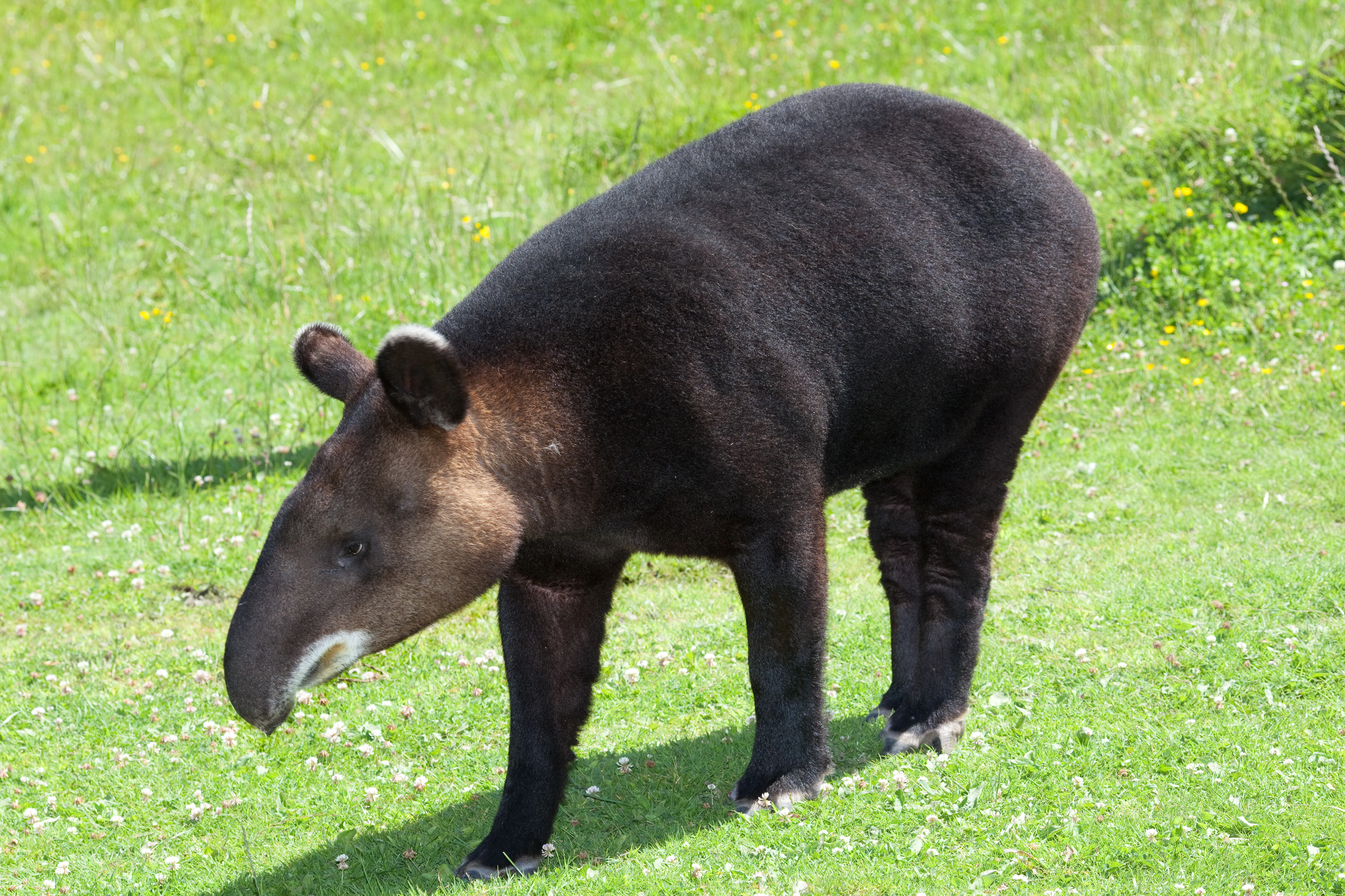
A mountain tapir, characterized by its thick dark fur and distinctive trunk-like nose, stands in profile on a green grassy meadow.
A mountain tapir walking through a grassy field.

Reserva Ecológica Cofán-Bermejo history and protected-area timeline

The formal establishment of Reserva Ecológica Cofán-Bermejo took place on January 30, 2002, when Ecuador's Ministry of the Environment issued Ministerial Agreement No. 16, creating the reserve under the framework of the country's national system of protected areas. The decree was published in the Official Gazette (Registro Oficial) No. 519 on February 21, 2002, marking the official beginning of the reserve's legal status.

While the legal declaration is recent, the conservation significance of the area predates it by millennia. The forests, rivers, and mountains protected by the reserve fall within the ancestral territory of the Cofán people, an indigenous nation whose presence in the upper Amazon stretches back centuries. The reserve's name reflects this deep indigenous heritage, pairing the Cofán identity with the Bermejo river basin that defines the area geographically.

Following its establishment, the reserve became part of Ecuador's broader process of decentralizing protected-area management. Administration was placed in the hands of the local Cofán communities through the Federación Indígena de la Nacionalidad Cofán del Ecuador (FEINCE), working alongside the Fundación para la Sobrevivencia del Pueblo Cofán (Foundation for the Survival of the Cofán People). This cooperative model recognized the indigenous communities as the primary stewards of the land, while maintaining coordination with the national Dirección Nacional de Biodiversidad y Áreas Naturales Protegidas.

Since its creation, the Cofán communities and partner organizations have developed a range of conservation and cultural programs within and around the reserve. These include captive breeding initiatives for Amazonian turtles, environmental education for Cofán youth, the production and sale of traditional crafts, community-based ecotourism, and the construction and commercialization of eco-canoes. Together, these efforts reflect a vision of conservation that integrates biodiversity protection with the cultural and economic vitality of the indigenous Cofán nation.

Reserva Ecológica Cofán-Bermejo landscape and geographic character

The landscape of Reserva Ecológica Cofán-Bermejo is defined by its dramatic transition from lowland Amazonian rainforest to high Andean terrain. The reserve occupies the upper drainage of the Bermejo river system, including the headwaters of the Bermejo, Chandia Na'en, and Ccuccono rivers, with elevations ranging from approximately 400 meters along the river valleys to about 2,200 meters on the ridges and peaks near Cerro Sur Pax.

At lower elevations, between roughly 400 and 950 meters, the terrain features humid tropical rainforests occupying river valleys, steep slopes, and the margins of streams and quebradas. Dense canopy cover, high humidity, and rich alluvial soils characterize this zone. Above 950 meters, the forest changes character, becoming montane evergreen forest with greater structural complexity, taller trees in some areas, and the onset of mossy, cloud-forest conditions as elevation increases.

From about 1,500 meters upward, the landscape transitions into stunted elfin forest, dense ridge-top vegetation, and eventually open páramo grasslands near the summits of Cerro Sur Pax and surrounding peaks. This altitudinal gradient creates a striking physical sequence within a relatively compact geographic area: steaming lowland forests in the river valleys give way, within just a few kilometers horizontally, to cool mossy ridges and windswept high-elevation grasslands. The reserve's largely undisturbed condition means that these transitions occur naturally and continuously, without significant fragmentation from roads or large-scale agriculture.

Reserva Ecológica Cofán-Bermejo ecosystems, habitats, and plant life

The ecological character of Reserva Ecológica Cofán-Bermejo is shaped by its position at the convergence of two of the most biodiverse regions on Earth, the Amazon basin and the tropical Andes. Where these two biogeographic realms meet, between roughly 1,000 and 1,800 meters of elevation, the reserve harbors a particularly rich and complex community of plants, with significant heterogeneity in forest composition and structure.

Botanical explorations have documented at least 800 species of plants within the reserve, including species new to science. Notably, a previously undescribed species in the bromeliad family was discovered here, and approximately half of all palm species known from the eastern Ecuadorian region are found within the reserve's boundaries. The site is also considered a possible center of diversity for the Rubiaceae plant family.

The vegetation shows a clear ecological pattern: species diversity is highest in the lowland forests and decreases as elevation climbs toward the Andean ridges and páramo. This gradient, combined with the convergence of two major floristic regions, gives the reserve an unusually layered botanical identity. Distinct forest types are recognizable, including lowland slope forests along rivers and quebradas (400 to 950 meters), high-slope montane forests (950 to 1,500 meters), and ridge-top and summit forests (1,500 to 2,300 meters), with the highest elevations edging into páramo vegetation.

Reserva Ecológica Cofán-Bermejo wildlife and species highlights

Reserva Ecológica Cofán-Bermejo supports an exceptionally rich and, in some cases, globally unique fauna. Avian diversity is particularly notable, with potentially as many as 700 bird species recorded or expected within the reserve's boundaries. The reserve is recognized internationally as an Important Bird and Biodiversity Area under BirdLife International.

Among the reserve's most significant bird records is the Black Tinamou (Tinamus osgoodi), documented here as the only confirmed site in Ecuador. The reserve is also one of the few areas in the country where the recently described Foothill Elaenia (Myiopagis olallai) occurs, and it supports important populations of several restricted-range or threatened species, including the Military Macaw (Ara militaris), the Spot-winged Parrotlet (Touit stictoptera), the Buff-fronted Owl (Aegolius harrisii), the Emerald-bellied Puffleg (Eriocnemis alinae), the Moustached Antpitta (Grallaria alleni), and the Wattled Guan (Aburria aburri).

Mammalian diversity is equally significant. At least 42 species of large mammals have been recorded, including 12 species considered threatened with extinction. Among the most notable are the Andean tapir (Tapirus pinchaque), the giant armadillo (Priodontes maximus), the bush dog (Speothos venaticus), and the short-eared dog (Atelocynus microtis). The reserve is also home to 12 primate species and the spectacled bear (Tremarctos ornatus), a species considered a symbol of Andean conservation. Herpetological surveys have documented 31 species of amphibians and reptiles, with several potentially new to science still under study.

Reserva Ecológica Cofán-Bermejo conservation status and protection priorities

Reserva Ecológica Cofán-Bermejo holds exceptional conservation significance at both national and international levels. It is designated as an IUCN Category Ia strict nature reserve, the highest and most restrictive level of protection in the IUCN framework, reserved for areas managed primarily for scientific research, ecosystem protection, and the preservation of biodiversity, with very limited human intervention.

The reserve is also recognized as an Important Bird and Biodiversity Area (IBA) by BirdLife International, reflecting its global importance for bird conservation. Its combination of pristine habitat, altitudinal diversity, and high species richness makes it a priority site for the conservation of Amazonian and Andean biodiversity alike. The reserve continues to yield new scientific discoveries, including new plant and potentially new animal species, underscoring its role as a living laboratory for understanding tropical ecology.

What distinguishes Cofán-Bermejo from many other strictly protected areas is its governance model. The reserve is administered not by a centralized government agency but by the indigenous Cofán communities of Sinangoe, through the Federación Indígena de la Nacionalidad Cofán del Ecuador (FEINCE) and the Fundación para la Sobrevivencia del Pueblo Cofán. This model of indigenous-led conservation has been credited with maintaining the area's largely pristine condition. Community-led conservation programs within and around the reserve include captive breeding of Amazonian turtles, environmental education, sustainable crafts production, community-based ecotourism, and the manufacture and sale of eco-canoes, demonstrating that biodiversity protection and indigenous cultural continuity can reinforce one another.

Reserva Ecológica Cofán-Bermejo cultural meaning and human context

Reserva Ecológica Cofán-Bermejo is deeply intertwined with the cultural identity and ancestral territory of the Cofán people, an indigenous nation whose presence in the upper Amazon basin of Ecuador and Colombia extends back many centuries. The reserve protects lands that form part of the traditional territory of the Cofán community of Sinangoe, and its very name acknowledges this indigenous heritage.

Within and around the reserve, Cofán communities continue to practice traditional subsistence activities, including small-scale agriculture, hunting, and fishing, often in zones carefully integrated with the surrounding forest. These activities reflect a long-standing relationship with the landscape that predates the formal establishment of the reserve by generations.

Indigenous stewardship is central to the reserve's identity. The Federación Indígena de la Nacionalidad Cofán del Ecuador (FEINCE) and the Fundación para la Sobrevivencia del Pueblo Cofán serve as the primary administrators of the protected area, working in coordination with Ecuador's national environmental authorities. Community programs such as the captive breeding of Amazonian turtles, environmental education for younger generations, and the production of traditional crafts and eco-canoes reflect an integrated approach to conservation that values both biodiversity and cultural survival. For the Cofán nation, the reserve represents not only an ecological sanctuary but also a living affirmation of their enduring relationship with their ancestral forest homeland.

Top sights and standout views in Reserva Ecológica Cofán-Bermejo

Reserva Ecológica Cofán-Bermejo stands out as a place where Andean cloud forest, Amazonian rainforest, and páramo converge within a single, largely pristine protected landscape. The reserve's altitudinal gradient produces a vertical sequence of ecosystems found in very few other places on Earth, supporting exceptional botanical diversity, including 800 documented plant species and a remarkable convergence of regional floras.

Its wildlife profile is equally distinctive. As the only site in Ecuador where the Black Tinamou is reliably recorded, and a global stronghold for threatened species such as the Military Macaw, the Andean tapir, and the spectacled bear, the reserve carries genuine international conservation weight. Ongoing discoveries of new plant and animal species continue to add to its scientific importance, making it a natural reference site for research on tropical biodiversity and ecological transitions.

Equally compelling is the reserve's governance model. Administered by the indigenous Cofán communities through their own federation and foundation in coordination with the Ecuadorian state, Cofán-Bermejo exemplifies indigenous-led conservation in practice. Programs in turtle breeding, eco-canoes, and community-based ecotourism demonstrate that the reserve is not a fortress of exclusion but a living landscape where ecological and cultural futures are pursued together.

Best time to visit Reserva Ecológica Cofán-Bermejo

Because Reserva Ecológica Cofán-Bermejo lies in the upper Amazon of northeastern Ecuador, the climate is humid and warm year-round, with relatively little seasonal temperature variation. The area experiences a wetter season and a somewhat drier season, typical of the western Amazon, and rainfall patterns tend to influence both river levels and accessibility of trails and lowland areas.

The drier months, generally associated with the latter part of the year in this part of Ecuador, often bring more comfortable conditions for trekking in lowland forests and for observing terrestrial wildlife along forest edges and riverbanks. Birding tends to be productive throughout the year, given the reserve's exceptional species richness, though some bird activity peaks during periods when fruiting trees are most abundant in the forest canopy.

Because much of the reserve's identity depends on its full elevational sequence, from the lowland Bermejo valley to the páramo of Cerro Sur Pax, timing of a visit can influence which parts of the landscape are most rewarding. Lower elevations are lush and vibrant during the wet season, while higher elevations under clearer skies can offer striking views of the convergence of Andes and Amazon. Given the reserve's indigenous governance and the community-led nature of ecotourism, planning any visit in close coordination with the Cofán communities of Sinangoe is part of the experience itself.
Monthly climate preview

Long-term temperature ranges and monthly precipitation patterns across representative terrain

Reserva Ecológica Cofán-Bermejo Climate Normals and Annual Weather Rhythm

Representative coordinate records show measured temperature and precipitation variations across the year at an elevation of 2,174 meters. Accessing the complete monthly climate profile reveals detailed twelve-month averages for deeper environmental analysis.
Annual mean15 °C
13 °C15 °C
Jan15°
Feb15°
Mar15°
Apr15°
May14°
Jun14°
Jul13°
Aug14°
Sep15°
Oct15°
Nov15°
Dec15°
Warmest month
November

15.3 °C

Coolest month
July

13.2 °C

Wettest month
November

4.4 mm/day

Driest month
August

1.4 mm/day

Park location guide

Geography guide, regional context, and park location map for Reserva Ecológica Cofán-Bermejo

Reserva Ecológica Cofán-Bermejo park geography, regions, and map view in Ecuador

Understand where Reserva Ecológica Cofán-Bermejo sits in Ecuador through a broader geographic reading of the surrounding landscape, nearby location context, and its mapped position within the national park landscape.

How Reserva Ecológica Cofán-Bermejo fits into Ecuador

Ecuador is a presidential republic located in northwestern South America, with Quito as its capital and Guayaquil as its largest city. The country spans 283,561 km² and encompasses the Galápagos Islands, a volcanic archipelago famous for unique wildlife that helped shape Darwin's theory of evolution. Ecuador is a plurinational state with Spanish as the official language, though Kichwa and Shuar are recognized for indigenous peoples.

Wider geography shaping Reserva Ecológica Cofán-Bermejo in Ecuador

Ecuador is located in northwestern South America along the Pacific coast. It shares borders with Colombia to the north and Peru to the east and south. The country includes the Galápagos Islands, a volcanic archipelago in the Pacific Ocean approximately 1,000 km west of the mainland. The territory encompasses diverse terrain including the Amazon rainforest in the east, the Andean highlands in the center, and coastal plains along the Pacific.

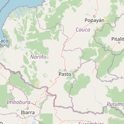
Map view of Reserva Ecológica Cofán-Bermejo

Use this park location map to pinpoint Reserva Ecológica Cofán-Bermejo in Ecuador, understand its exact geographic position, and read its mapped placement within the surrounding landscape more clearly.

Pigeon | © OpenStreetMap contributors

Location context for Reserva Ecológica Cofán-Bermejo

Sucumbíos
Recorded earthquake history

Explore Historical Earthquake Records for Reserva Ecológica Cofán-Bermejo

Access a structured collection of documented seismic activity occurring near Reserva Ecológica Cofán-Bermejo. This data serves as a comprehensive resource for understanding the historical landscape of seismic events in the region. MoriAtlas compiles these records to support precise geographic discovery of protected areas.

Reserva Ecológica Cofán-Bermejo Earthquake Records

Catalogued events

28 events

Strongest magnitude

Magnitude 7.2

Most recent event

May 6, 2024

This history includes earthquakes recorded inside the park or within 50 km of its borders

Explore photographic records of the transition zone, featuring lowland rainforest, cloud forest, and páramo habitats

Reserva Ecológica Cofán-Bermejo Photos and Landscapes: Visualizing Amazonian and Andean Ecosystems

Photographic collections reveal the complex terrain, river basins, and altitudinal gradients defining Reserva Ecológica Cofán-Bermejo. Visual records provide essential context for understanding the remote habitats and transitional ecosystems spanning from river valleys to mountain ridges.

A mountain tapir, characterized by its thick dark fur and distinctive trunk-like nose, stands in profile on a green grassy meadow.

Two green Military Macaws with prominent red patches on their faces and blue tail feathers perched on a weathered tree stump in a dense jungle setting.

Park atlas

Compare nearby national parks and connected protected landscapes across the regional terrain

Explore Other Parks Near Reserva Ecológica Cofán-Bermejo and Surrounding Protected Areas

Browse other protected areas near Reserva Ecológica Cofán-Bermejo to compare transitional ecosystems, river headwaters, and mountain habitats. Expanding the geographic view helps trace regional conservation networks across the surrounding region.
National parkEcuador
30 km away#1 closest

South

Sumaco Napo-Galeras National Park: Ecuador's Volcanic National Park Landscape

Explore protected areas and biodiversity in the Andean-Amazon transition.

Sumaco Napo-Galeras National Park protects a dramatic volcanic landscape in Ecuador, showcasing a significant elevation gradient that supports diverse cloud forest and Amazonian rainforest habitats. This national park is recognized for its endemic species and rich avifauna, offering a compelling case study for understanding protected land geography and ecological transitions within South America.

Area
2,067.49 km²
Established
1994
IUCN
II
Relief
Mountain
A horizontal watercolor painting depicting a purple mountain range in the background behind soft green rolling hills and a stream in the foreground.
National parkEcuador
About 47 km away#2 closest

Southwest

Parque nacional Cayambe-Coca: Regional Geography and Protected Landscape Analysis

Equatorial volcanic peaks and Amazonian slope geography

Examine the physical geography of Parque nacional Cayambe-Coca, a protected area in Ecuador known for its extreme elevation shifts. The mapped terrain transitions from the glaciated summit of Volcán Cayambe through extensive páramo wetlands and montane cloud forests into the Amazonian foothills, providing a comprehensive case study of Andean environmental gradients.

Area
4,031.03 km²
Established
1970
IUCN
II
Relief
Mountain
Nature reserveCarchi Province
52 km away#3 closest

Northwest

Reserva ecológica El Ángel: High-Andean Protected Landscape and Geography Map

Exploring páramo ecosystems in Carchi Province, Ecuador

Reserva ecológica El Ángel is a crucial conservation area in the northern Andes, defined by its high-altitude páramo, volcanic geology, and extensive wetland network. It serves as a vital hydrological heart for Carchi Province, supporting diverse highland vegetation including dense stands of giant frailejón and ancient Polylepis forests across a dramatic, glacially-sculpted terrain.

Area
165.41 km²
Established
1992
IUCN
Ia
Relief
Mountain
Protected areaColombia
About 61 km away#4 closest

Northeast

Santuario Orito Indí-Andé Fauna and Flora Sanctuary: A Protected Area's Geographic and Landscape Identity in Colombia

Explore mapped boundaries and regional natural terrain context.

Gain insight into Santuario Orito Indí-Andé Fauna and Flora Sanctuary, a vital protected area contributing to Colombia's conservation landscape. This entry focuses on its distinct geographic characteristics and mapped territory. Understand the park's place within the national atlas and its contribution to regional geographic knowledge. It provides a structured foundation for exploring the natural terrain and protected boundaries specific to this important Colombian sanctuary.

Area
1,020 km²
Established
2008
Relief
Mountain
Access
Access unknown
Wildlife reserveSucumbíos
66 km away#5 closest

East

Reserva de Producción de Fauna Cuyabeno: Geography of an Amazonian Wildlife Reserve

Explore protected boundaries and flooded landscape patterns in Sucumbíos

Reserva de Producción de Fauna Cuyabeno serves as a benchmark for Amazonian conservation, characterized by its extraordinary hydrological dynamics. The landscape comprises a network of blackwater rivers and semi-permanent lagoons that sustain an immense variety of species. As a protected area within Sucumbíos, it showcases the intricate relationship between seasonally submerged forests, terra firme terrain, and the vital river arteries that define this region.

Area
5,901.12 km²
Established
1979
IUCN
VI
Visitors
12K annual
Watercolor painting of a lake with green hills and trees in the background
Protected areaNariño
About 83 km away#6 closest

North

La Corota Island Flora Sanctuary: A Unique Protected Area within Colombia's Nariño Region

Explore its Andean cloud forest landscape and mapped island geography.

La Corota Island Flora Sanctuary is a critical protected area in Nariño, Colombia, celebrated for its distinctive status as the country's only lake island ecosystem supporting old-growth Andean cloud forest. This compact sanctuary provides a unique landscape context, safeguarding endemic plant species and diverse birdlife within its mapped boundaries. Its presence within Laguna de la Cocha highlights a special convergence of wetland and forest geography, offering insights for atlas exploration of protected lands.

Area
0.152 km²
Established
1977
IUCN
II
Visitors
28K annual
A horizontal watercolor painting showing layers of rolling green hills, a pink-toned foreground meadow, and distant hazy mountain ridgelines against a light background.
National parkImbabura
86 km away#7 closest

West

Cotacachi Cayapas National Park: A Study of Andean and Chocó Protected Geographic Landscapes

Exploring the extreme vertical transition across the northern Ecuadorian Andes

Cotacachi Cayapas National Park stands as a vital protected area, linking high-altitude páramo around Volcán Cotacachi to the lowland forests of the Chocó. The park features the iconic Laguna de Cuicocha and a dramatic range of ecosystems that define its complex terrain. This resource offers a clear look at the park's boundaries, geological features, and the distinct ecological zones that make it a central pillar of northern Ecuadorian geography.

Area
2,609.61 km²
Established
1968
IUCN
II
Visitors
50.2K annual
Watercolor illustration of a mountain range with a lake in the foreground, green fields, and a colorful sky
Protected areaColombia
About 89 km away#8 closest

North

Galeras Protected Area: Exploring Colombia's Mapped Natural Landscapes

Discover the geography and protected terrain of Galeras.

The Galeras protected area in Colombia offers a distinct opportunity for geographic exploration, focusing on its defined boundaries and the natural landscape it encompasses. This resource details the park's setting within the Colombian geography, providing a map-centric view of its protected status. Understanding Galeras contributes to a broader appreciation of protected lands across South America and their unique terrain.

Relief
Mountain
Climate
Alpine
Access
Highly restricted

Common questions about visiting, size, designation, and location context for Reserva Ecológica Cofán-Bermejo

Reserva Ecológica Cofán-Bermejo FAQs for park facts, access, geography, and protected area context

Find quick answers about Reserva Ecológica Cofán-Bermejo, including protected-area facts, park geography, trail and visitor context, and how the park fits into its surrounding country and regional landscape.
MoriAtlas Explorer

Continue Your Protected Areas Search Across the Global Atlas

Deepen your exploration by continuing the structured search for national parks and protected areas worldwide. Utilize the comprehensive filtering capabilities to compare different conservation landscapes and refine your understanding of global park geography. Discover more about the distribution and characteristics of protected natural areas.

Global natural geography