
Mori Atlas logo
Wildlife reserveRéserve nationale de faune des îles de l'Estuaire

Discover the mapped landscape and protected island chain along the St. Lawrence Estuary shoreline.

Réserve nationale de faune des îles de l'Estuaire: A Vital Wildlife Reserve in the Quebec Estuary

The Réserve nationale de faune des îles de l'Estuaire protects a string of islands and islets spanning 120 kilometres across the St. Lawrence Estuary in Quebec. This wildlife reserve serves as a crucial refuge for common eider colonies and marine mammals; its low rocky islands and surrounding tidal flats form an essential part of the regional marine conservation network.

St. Lawrence Estuaryislandsnational wildlife areaseabird coloniescommon eidermarine mammals
A flat-design illustration showing a serene coastal scene with a lighthouse on a rocky, tree-covered island, surrounded by water and a pebbled shoreline with seaweed in the foreground.

Réserve nationale de faune des îles de l'Estuaire

Wildlife reserve

Park overview

Structured park overview, official facts, and landscape profile for Réserve nationale de faune des îles de l'Estuaire

Réserve nationale de faune des îles de l'Estuaire park facts, protected area profile, and essential visitor context

Review the core facts for Réserve nationale de faune des îles de l'Estuaire, including designation, size, terrain, visitor scale, habitats, and operating context in one park-focused overview.

About Réserve nationale de faune des îles de l'Estuaire

The Réserve nationale de faune des îles de l'Estuaire is a chain-like national wildlife area in the St. Lawrence Estuary, one of eight national wildlife areas that fall within the province of Quebec. Its territory is a string of about ten islands or partial islands arrayed along roughly 120 kilometres of coastline between the communities of Kamouraska and Rimouski. Although the total surface area is modest, the geographic spread gives the reserve a meaningful presence across a long section of one of North America's most important marine ecosystems.

The reserve's defining role is the protection of island habitat free from heavy terrestrial predator pressure, a condition that emerges from the islands' physical isolation rather than from active management alone. This makes the area exceptionally valuable for colonial nesting seabirds and other ground-nesting birds. Its flagship feature is the common eider breeding colony on Île Bicquette, recognized as the most important in the St. Lawrence Estuary. The islands also support seals that haul out on their tidal flats and a marine environment rich in forage fish, groundfish, and shellfish.

Administratively, the reserve spans two regional county municipalities: Kamouraska and Rimouski-Neigette. It includes portions of the Kamouraska Islands, parts of the Pèlerins archipelago, a portion of Pont du Phare and its tidal flats within the Pot à l'Eau-de-Vie Islands, Île Blanche, Île aux Fraises, and Île Bicquette. Several nearby islands are owned by conservation non-profits rather than the federal government, but the reserve forms the core federal anchor that ties the broader estuarine protection network together. Three of the reserve's islands, Île aux Fraises, Île Blanche, and the Pont du Phare, are encircled by the Saguenay–Saint-Laurent Marine Park, adding another layer of marine protection around them.

Quick facts and research context for Réserve nationale de faune des îles de l'Estuaire

Located in the St. Lawrence Estuary along the Bas-Saint-Laurent coast of Quebec, this national wildlife area consists of about ten small islands or island fragments scattered between Kamouraska and Rimouski. The reserve was established on 19 June 1986 and is administered by the Canadian Wildlife Service, working with conservation non-profits such as Société Duvetnor and the Société protectrice des Eiders de l'Estuaire.

The islands are low, with maximum elevations only around thirty metres, and sit on Cambrian to Ordovician sedimentary rocks of sandstone, schist, and conglomerate. Their isolation from the mainland makes them important habitat for nesting seabirds, especially the common eider colony on Île Bicquette, and the islands connect to a wider St. Lawrence conservation network that includes the Saguenay–Saint-Laurent Marine Park.

Protection and recognition

Examine the official protection scope, management framework, and recognized status for Réserve nationale de faune des îles de l'Estuaire.

Réserve nationale de faune des îles de l'Estuaire Protection Status and Designated Area Record

Comprehensive protected area records outline the mixed conservation status and designated framework established for Réserve nationale de faune des îles de l'Estuaire. Structured regulatory facts deliver clear insight into the management scope and official administrative parameters governing the protected landscape.

Protection details

Protection scope
Mixed
Transboundary protection
No
WDPA ID
555637769
Park context

Deeper park guide and search-rich context for Réserve nationale de faune des îles de l'Estuaire

Réserve nationale de faune des îles de l'Estuaire history, landscape, wildlife, and travel context

Explore Réserve nationale de faune des îles de l'Estuaire through its history, landscape character, ecosystems, wildlife, conservation priorities, cultural context, and seasonal travel timing in a structured park guide built for atlas discovery and search intent.

Why Réserve nationale de faune des îles de l'Estuaire stands out

The reserve is best known for protecting the largest common eider colony in the St. Lawrence Estuary, on Île Bicquette. This dense seabird breeding concentration has become one of the defining features of the national wildlife area and a key justification for its protected status. Beyond eiders, the reserve is also valued for the way its low, predator-poor islands act as natural refuges for other colonial nesting birds, waterbirds, and seals along a heavily trafficked stretch of the St. Lawrence. The combination of seabird colonies, haul-out sites for grey and harbour seals, and proximity to the beluga's range gives it an outsized role for an area of only a few hundred hectares.
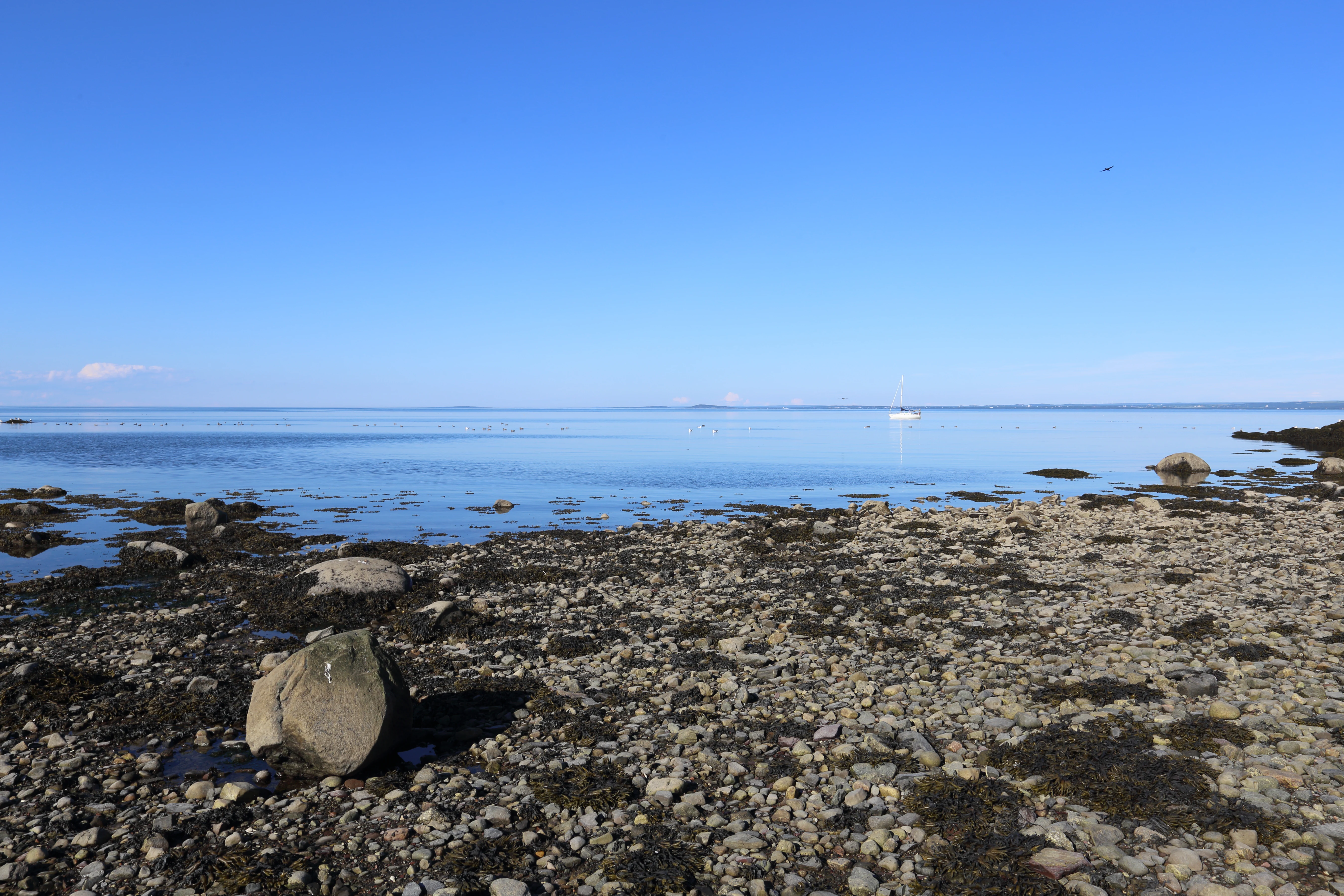
A rocky, pebble-covered shoreline leads to calm, blue water under a clear sky.
A calm shoreline view of the Pot a l'Eau-de-Vie islands in the Saint Lawrence estuary.

Réserve nationale de faune des îles de l'Estuaire history and protected-area timeline

Before European contact, the islands of the St. Lawrence Estuary were seasonal hunting grounds for the Innu, whose territory extended along the north shore of the river and across its islands to the south shore. Neighbouring nations such as the Mi'kmaq and the Maliseet also used lands and waters nearby, and all of these communities experienced profound disruption and decline following colonization. Today, the Bas-Saint-Laurent region's only Indigenous community is the Première Nation malécite de Viger, including reserves at Whitworth and Cacouna near Rivière-du-Loup.

European colonization of Bas-Saint-Laurent proceeded slowly under the French seigneurial system. Between 1653 and 1751, nineteen seigneuries were granted in the region, and individual islands passed through various seigneurs. Île aux Fraises, Île Blanche, and Pont du Phare were granted to Simon François Daumont de Saint-Lusson on 7 November 1672. The Kamouraska islands were granted to Olivier Morel de La Durantaye in 1674, while Île Bicquette went to Charles Denys de Vitré on 6 May 1675 within the Seigneurie du Bic. The Pèlerins were granted in 1672 to Jean-Baptiste-François Deschamps de La Bouteillerie within the Seigneurie de la Rivière-Ouelle.

In modern times, the Canadian Wildlife Service assembled the reserve through negotiated purchases from private owners and ministerial transfers, and the national wildlife area was officially created on 19 June 1986. At the time of its establishment, several of the included islands also carried Migratory Bird Sanctuary status. Once the national wildlife area became operative, those overlapping sanctuaries were made obsolete and formally abolished in 1996.

Réserve nationale de faune des îles de l'Estuaire landscape and geographic character

The reserve sits along a long stretch of the St. Lawrence Estuary where the shoreline breaks into a chain of small islands, islets, and tidal flats. Altitudes are modest across the protected area, with maximum elevations only around thirty metres, giving the islands low, exposed silhouettes against the water. Coastlines alternate between rocky shores, vegetated flats, and broad tidal mud and gravel flats, known locally as battures, which surround many of the islands at low tide.

Beneath these surface features, the islands rest on ancient sedimentary rocks. Their bedrock is composed of sandstone, schist, and conglomerate formed between the early Cambrian and the Ordovician, more than 440 million years ago. The relatively soft, layered character of these rocks shapes the gently contoured shorelines and contributes to the mix of exposed substrate, tidal pools, and shallow subtidal zones along the islands.

The broader landscape context is marine rather than terrestrial. Several of the reserve's islands, including Île aux Fraises, Île Blanche, and the Pont du Phare, are ringed by the Saguenay–Saint-Laurent Marine Park, placing them within one of Canada's most significant marine conservation landscapes. The combination of small islands, surrounding tidal flats, deeper channels, and proximity to the open estuary creates the diversified seascape that defines the reserve's character.
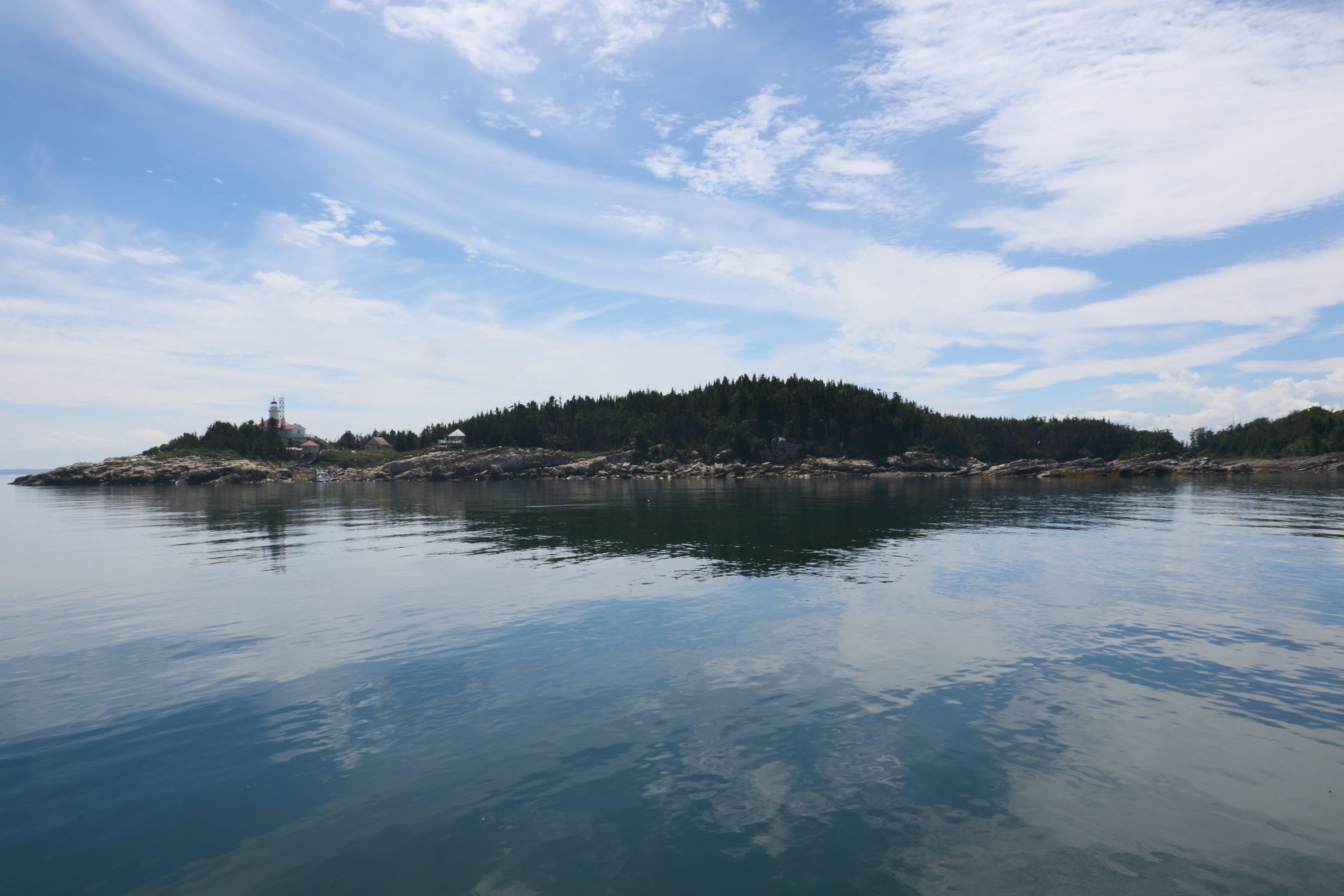
A calm, wide view of a small forested island with rocky shores, surrounded by reflective water under a blue sky with light clouds.
A view of the Pot a l'Eau-de-Vie Islands in the Saint Lawrence estuary.

Réserve nationale de faune des îles de l'Estuaire ecosystems, habitats, and plant life

Ecologically, the reserve occupies the sugar maple-yellow birch bioclimatic domain, yet its true vegetation is shaped by maritime conditions rather than continental forest norms. The islands are dominated by balsam fir and paper birch stands, with black spruce-white spruce associations also present, plus scattered American mountain ash, pin cherry, trembling aspen, and balsam poplar. Herbaceous communities include grasses of the genus Calamagrostis and a variety of annual plants, and disturbances from grazing animals can promote ruderal species such as burdock.

Forest health on the islands has been shaped by both natural and biological pressures. Browsing by snowshoe hare has stripped many understory plants typical of mainland forests. Spruce budworm caused major damage in the 1970s on the Kamouraska islands and Pont du Phare, while the Pèlerins, dominated by black spruce, suffered less, and Île Bicquette, with an unusually old and dense forest, was largely spared though its woodland continues to decline for reasons that remain unclear. Cormorant colonies have also altered island vegetation through guano-driven die-back, especially on Île Blanche, Île Brûlée, Grande Île, and Pont du Phare.

Floristic inventories have documented 88 vascular plant species on Île aux Fraises, 50 on Île Blanche, and 151 on Pont du Phare, without yet recording any rare species on these three islands. In the marine environment, kelp beds of Laminaria occur between Bic Island and Île Bicquette and around the Pot à l'Eau-de-Vie Islands, while intertidal and shallow subtidal habitats around all the islands support beds of Ascophyllum and Fucus. The mix of terrestrial, intertidal, and subtidal habitats gives the reserve a layered ecological profile that reflects its position at the land-sea boundary.
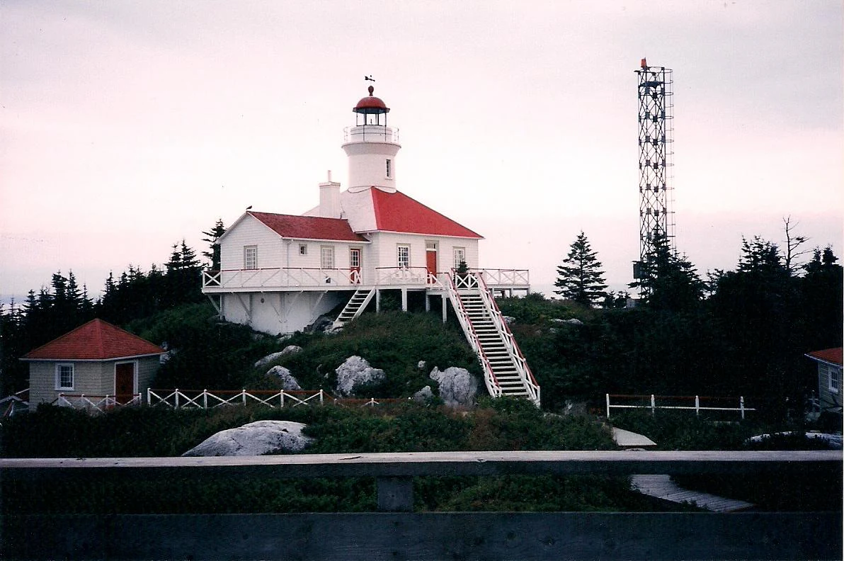
A white lighthouse with a red roof stands on a rocky island surrounded by evergreen trees, with a metal communications tower nearby.
The Pot a l'Eau-de-Vie lighthouse, a prominent historic structure located within the Réserve nationale de faune des îles de l'Estuaire.

Réserve nationale de faune des îles de l'Estuaire wildlife and species highlights

The wildlife of the reserve is shaped strongly by the absence of terrestrial predators on most islands, which allows colonial nesting birds to thrive. Red fox, long-tailed weasel, and black bear have all been recorded in the reserve; the red fox is the most damaging to nesting birds and is permanently present on Île aux Lièvres and Bic Island, occasionally reaching the reserve across winter ice. American mink and muskrat occur on Île Blanche and Île aux Fraises, snowshoe hare are present across the reserve, and moose and meadow vole have been observed on some of the Kamouraska islands. Île Blanche, Île aux Fraises, and Île Bicquette appear to lack any small mammal populations.

Marine mammals are a major component of the reserve's fauna. Grey seals form haul-outs on the tidal flats of Île Blanche and Île aux Fraises, while harbour seals haul out around the Kamouraska islands and the Pèlerins; the two species share shoreline space at Île Bicquette and Île Blanche. Several cetacean species occur in surrounding waters, including the St. Lawrence beluga, a year-round resident of the estuary.

Fish diversity in the surrounding waters is substantial. Atlantic herring spawns twice a year around the Pèlerins and Île aux Lièvres, sand lance and capelin are present in the reserve's waters, and American eel, American shad, Atlantic halibut, and Atlantic cod appear at different times around the island chain. No islands have freshwater streams capable of supporting freshwater fish. Invertebrate communities are equally varied: the softshell clam is abundant on Île Blanche and Île aux Fraises, the Stimpson's surf clam around Île Bicquette, and the green sea urchin is abundant enough to support a commercial spring and autumn fishery near Île Blanche and Île Bicquette, with American lobster and snow crab also found in nearby waters.

Réserve nationale de faune des îles de l'Estuaire conservation status and protection priorities

The reserve's conservation significance lies in how a small but strategically placed set of islands secures critical habitat in the middle of a heavily used marine system. By keeping its islands largely free of terrestrial predators, the area functions as a refuge for large colonies of nesting seabirds, most notably the common eiders of Île Bicquette, which represent the most important breeding concentration of this species in the entire St. Lawrence Estuary. The site's protected status under the national wildlife area designation adds legal weight to habitat protection in estuarine waters that are otherwise subject to shipping, fishing, and recreational pressure.

The reserve is also a keystone in a much broader conservation geography. Its territory overlaps with the Saguenay–Saint-Laurent Marine Park around several islands, and it sits alongside islands under conservation ownership by groups such as Société Duvetnor, the Nature Conservancy of Canada, and the Provancher Society of Natural History. This network of non-profit ownership, provincial biodiversity reserve planning on Île aux Lièvres, and federal protection through the national wildlife area gives the reserve a central place in estuary-wide habitat conservation.

The site's conservation challenges reflect this overlap of pressures and interests. Forest die-back from cormorant guano, old-growth decline on Île Bicquette, predation pressure on island seabirds, and the impacts of commercial fisheries such as the green sea urchin harvest all sit alongside the reserve's protected role. Managing these dynamics with the Canadian Wildlife Service and partner organizations is at the core of why the reserve exists as a federal protected area.

Réserve nationale de faune des îles de l'Estuaire cultural meaning and human context

The islands of the St. Lawrence Estuary have long-standing cultural significance for Indigenous peoples, especially the Innu, whose traditional territory spanned the north shore of the river and the islands reaching to the south side. The neighbouring Mi'kmaq and Maliseet also had traditional connections to lands and waters near the estuary, and these practices were deeply disrupted after European contact. The Malecite First Nation of Viger, including reserves at Whitworth and Cacouna near Rivière-du-Loup, remains the only Indigenous community in Bas-Saint-Laurent today, with Cacouna recognized as the smallest Indian reserve in Canada.

Following European colonization, the islands entered the French seigneurial system of New France. Between 1653 and 1751, nineteen seigneuries were granted along the Bas-Saint-Laurent coast, and individual islands such as Île aux Fraises, Île Blanche, Pont du Phare, the Kamouraska islands, Île Bicquette, and the Pèlerins were each granted to specific seigneurs in the 1670s. These early land grants shaped subsequent patterns of private island ownership, which later influenced the federal government's piecemeal acquisition strategy leading to the reserve's creation in 1986.

Top sights and standout views in Réserve nationale de faune des îles de l'Estuaire

A defining highlight of the reserve is the common eider breeding colony on Île Bicquette, the largest in the St. Lawrence Estuary and a key reason the area earned national wildlife area status. Supporting that colony is a wider network of low, mostly predator-free islands that give seabirds and seals reliable refuge across a 120-kilometre stretch of estuary shoreline.

Another significant highlight is the reserve's integration into a layered marine protection framework. Several islands fall within the boundaries of the Saguenay–Saint-Laurent Marine Park, and the reserve itself sits within a constellation of conservation-owned islands managed by groups such as Société Duvetnor and the Nature Conservancy of Canada. Together, these linkages make the reserve a small but central anchor for estuarine conservation in eastern Canada.

Best time to visit Réserve nationale de faune des îles de l'Estuaire

Visiting the islands of the reserve is closely tied to seasonal conditions in the St. Lawrence Estuary. Late spring and summer are the most ecologically meaningful period, when seabird colonies are active and common eiders nest on islands such as Île Bicquette. This is also when the surrounding marine environment is most biologically productive, and it tends to coincide with the quieter Atlantic herring and capelin cycles around the islands.

Late summer and early autumn bring other features, including the commercial green sea urchin fishery around Île Blanche and Île Bicquette. Winter often brings heavy ice across the estuary and can allow occasional predator movement onto the islands, reducing accessibility and increasing pressure on seabird populations. As the reserve is a protected federal wildlife area, access to individual islands is restricted and visitors typically need to plan around boat tours or interpretive programs offered through partner organizations.

Monthly climate preview

Long-term representative temperature and precipitation patterns across twelve monthly periods

Annual Climate Normals and Weather by Month for Réserve nationale de faune des îles de l'Estuaire

Representative coordinates record significant seasonal variations in average temperature and precipitation throughout the year at Réserve nationale de faune des îles de l'Estuaire. Examining the complete monthly climate normals provides a detailed baseline for evaluating long-term environmental patterns at this protected location.
Annual mean3 °C
-13 °C17 °C
Jan-13°
Feb-12°
Mar-6°
Apr
May
Jun14°
Jul17°
Aug17°
Sep13°
Oct
Nov-1°
Dec-9°
Warmest month
July

17.4 °C

Coolest month
January

-13.2 °C

Wettest month
June

3.3 mm/day

Driest month
January

1.8 mm/day

Park location guide

Geography guide, regional context, and park location map for Réserve nationale de faune des îles de l'Estuaire

Réserve nationale de faune des îles de l'Estuaire park geography, regions, and map view in Canada

Understand where Réserve nationale de faune des îles de l'Estuaire sits in Canada through a broader geographic reading of the surrounding landscape, nearby location context, and its mapped position within the national park landscape.

How Réserve nationale de faune des îles de l'Estuaire fits into Canada

Canada is a federal parliamentary constitutional monarchy spanning North America from the Atlantic to the Pacific and Arctic Oceans. With a population of over 41 million, it is officially bilingual in English and French at the federal level. The country gained independence from the United Kingdom through a gradual process culminating in 1982.

Wider geography shaping Réserve nationale de faune des îles de l'Estuaire in Canada

Canada occupies the northern portion of North America, sharing its longest international border with the United States. The country extends from the Atlantic Ocean to the Pacific Ocean and northward into the Arctic Ocean, giving it the longest coastline of any nation.

Map view of Réserve nationale de faune des îles de l'Estuaire

Use this park location map to pinpoint Réserve nationale de faune des îles de l'Estuaire in Canada, understand its exact geographic position, and read its mapped placement within the surrounding landscape more clearly.

Pigeon | © OpenStreetMap contributors

Location context for Réserve nationale de faune des îles de l'Estuaire

Quebec

Visualizing the island chain, tidal mud flats, and protected estuarine habitats

Réserve nationale de faune des îles de l'Estuaire Photos and Landscape Scenery

Photographs capture the low exposed silhouettes, rocky shorelines, and expansive tidal flats defining this St. Lawrence island chain. Visual exploration reveals the distinct estuarine terrain and protected seabird habitats supporting eastern Canada marine wildlife.

A rocky, pebble-covered shoreline leads to calm, blue water under a clear sky.

A wide shot of Bicquette Island, a low-lying island covered in greenery surrounded by the waters of the Saint Lawrence estuary, featuring a prominent white lighthouse.

A calm, wide view of a small forested island with rocky shores, surrounded by reflective water under a blue sky with light clouds.

A white lighthouse with a red roof stands on a rocky island surrounded by evergreen trees, with a metal communications tower nearby.

Park atlas

Compare related protected areas and marine conservation landscapes across the surrounding region

Parks Near Réserve nationale de faune des îles de l'Estuaire

Browsing other parks near Réserve nationale de faune des îles de l'Estuaire reveals connected marine reserves and protected island habitats across the St. Lawrence Estuary. Comparing adjacent conservation lands provides deeper geographical context for coastal wildlife refuges and estuarine protected areas.
Wildlife reserveQuebec
About 24 km away#1 closest

Northeast

Zugvogelschutzgebiet L’Isle-Verte Wildlife Reserve: Coastal Marsh and St. Lawrence Estuary Geography

Protected wetland boundaries and estuarine landscape in Quebec, Canada

Discover the geographic layout of Zugvogelschutzgebiet L’Isle-Verte, a specialized wildlife reserve in Quebec. This protected area centers on a productive tidal marsh system along the St. Lawrence Estuary, serving as an internationally recognized site for migratory waterfowl and shorebirds. The map-focused overview highlights the unique coastal terrain and the ecological significance of this narrow but vital strip of protected land.

Area
3.76 km²
Established
1986
IUCN
IV
Relief
Lowland
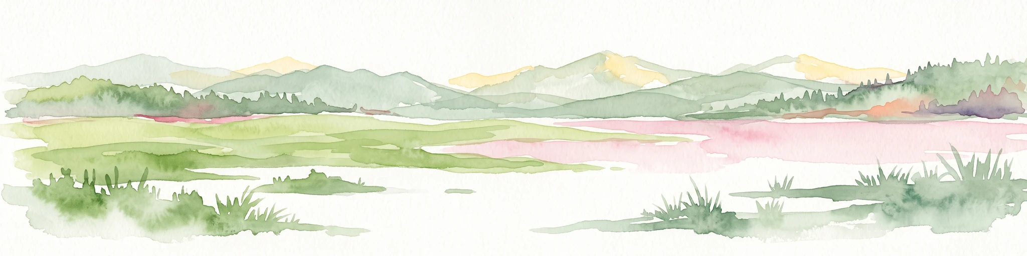
A pale, soft watercolor landscape painting showing a marshy coastline with low hills in the distance, rendered in muted greens, pinks, and purples on a white background.
Wildlife reserveBas-Saint-Laurent
About 27 km away#2 closest

East

Réserve nationale de faune de la baie de l'Isle-Verte: Bas-Saint-Laurent Protected Wildlife Area

Coastal salt marsh geography and waterfowl conservation sanctuary

Situated along the St. Lawrence Estuary, this wildlife reserve safeguards a rare and expansive tidal marsh environment. The area provides essential habitat for large migratory bird populations, serving as a landmark site for waterfowl conservation within the regional landscape of Bas-Saint-Laurent.

Area
3.2 km²
Established
1980
IUCN
IV
Relief
Lowland
National parkQuebec
About 263 km away#3 closest

Southwest

La Mauricie National Park: Quebec National Park Atlas and Protected Landscape

Explore its mapped boundaries and natural terrain.

Delve into the protected landscape of La Mauricie National Park, a key national park situated within Quebec's diverse geography. This destination provides detailed insights into the park's mapped boundaries and its unique natural terrain, offering a structured approach to understanding protected areas and regional landscapes. It serves as an essential point for exploring the park's geographic identity and its place within the Canadian conservation atlas.

Area
536 km²
Established
1970
IUCN
II
Visitors
278.9K annual
Wildlife reserveNew Brunswick
About 339 km away#4 closest

Southeast

Portobello Creek National Wildlife Area: Protected Wetland Geography and Regional Atlas

Saint John River floodplain reserve in New Brunswick

Portobello Creek National Wildlife Area protects an expansive wetland complex characterized by riverine marshes, shrub thickets, and low-lying floodplain forests. As a key site within the Saint John River system, the reserve offers unique insight into the geomorphic and ecological character of Atlantic Canadian wetlands.

Area
21.54 km²
Established
1995
IUCN
Ia
Relief
Lowland
Wildlife reserveQuebec
About 357 km away#5 closest

Southwest

Réserve nationale de faune des îles de Contrecœur: Mapped Wildlife Reserve and Wetland Habitat

Protected freshwater ecosystems in the St. Lawrence River, Quebec

Discover the geographic footprint of the Réserve nationale de faune des îles de Contrecœur, a protected network of islands and channels in the St. Lawrence River. This entry provides context on the reserve's role in conserving emergent aquatic vegetation and waterfowl nesting sites within the broader southern Quebec landscape.

Area
3.12 km²
Established
1981
IUCN
Ia
Relief
Lowland
Wildlife reserveNew Brunswick
About 358 km away#6 closest

East

Île-du-Portage National Wildlife Area: Geographic Overview and Protected Island Mapping

A vital estuarine reserve on the New Brunswick coast

Study the coastal terrain of Île-du-Portage National Wildlife Area, an uninhabited island reserve situated at the junction of the Miramichi River and the Northumberland Strait. This overview focuses on the island's role as one of five National Wildlife Areas in New Brunswick, highlighting its significance within the broader estuarine geography and coastal maritime history of the Atlantic region.

Area
3.49 km²
Established
1979
IUCN
Ia
Relief
Lowland
National parkNew Brunswick
About 368 km away#7 closest

East

Kouchibouguac National Park: New Brunswick Protected Landscape Atlas

Mapped protected area boundaries and regional geography.

Kouchibouguac National Park is a designated national park offering a rich canvas for geographic discovery. This entry focuses on understanding its protected landscape, detailing its specific mapped boundaries within New Brunswick. It serves as a vital component for atlas exploration, providing the context needed to grasp the park's natural terrain and its significance within the regional geography.

Area
238 km²
Established
1969
IUCN
II
Visitors
243.5K annual
Protected landscapeNew Hampshire
About 391 km away#8 closest

South

White Mountain National Forest: Protected Landscape Atlas and Geographic Boundary Context

Mapping the alpine ridges and river valleys of New Hampshire

Delve into the geography of White Mountain National Forest, a primary federal protected landscape in the eastern United States. This overview details the mountainous terrain, including the Presidential Range and Pemigewasset Wilderness, providing a clear window into its spatial scale, watershed boundaries, and regional prominence within the New England landscape.

Area
3,038.59 km²
Established
1918
Relief
Mountain
Climate
Temperate

Common questions about visiting, size, designation, and location context for Réserve nationale de faune des îles de l'Estuaire

Réserve nationale de faune des îles de l'Estuaire FAQs for park facts, access, geography, and protected area context

Find quick answers about Réserve nationale de faune des îles de l'Estuaire, including protected-area facts, park geography, trail and visitor context, and how the park fits into its surrounding country and regional landscape.
MoriAtlas Explorer

Continue Your Protected Areas Search Across the Global Atlas

Deepen your exploration by continuing the structured search for national parks and protected areas worldwide. Utilize the comprehensive filtering capabilities to compare different conservation landscapes and refine your understanding of global park geography. Discover more about the distribution and characteristics of protected natural areas.

Global natural geography