

Mori Atlas logo
Nature reserveRéserve naturelle intégrale de Betampona

Discover the mapped terrain and ridge lines of Madagascar's first established nature reserve

Réserve naturelle intégrale de Betampona: A Legacy of Protected Forest and Watershed Geography

Réserve naturelle intégrale de Betampona stands as a crucial ecological refuge within the Analanjirofo region of Madagascar, representing one of the last sizeable fragments of lowland humid evergreen forest on the eastern coast. This protected massif features a dissected landscape of steep ridges, forested valleys, and twelve permanent rivers that form the backbone of a dense hydrological network. By studying the reserve's boundaries and topographic elevation, observers can better understand the critical role this humid forest fragment plays in preserving Madagascar's endemic biodiversity.

rainforestlowland humid forestendemic specieslemursMadagascarisland biodiversity

Réserve naturelle intégrale de Betampona

Nature reserve

Park overview

Structured park overview, official facts, and landscape profile for Réserve naturelle intégrale de Betampona

Réserve naturelle intégrale de Betampona park facts, protected area profile, and essential visitor context

Review the core facts for Réserve naturelle intégrale de Betampona, including designation, size, terrain, visitor scale, habitats, and operating context in one park-focused overview.

About Réserve naturelle intégrale de Betampona

The Réserve naturelle intégrale de Betampona occupies a rugged forested massif in the Analanjirofo region of eastern Madagascar, between the communes of Sahambala and Ambodiriana. Lying inland from Toamasina, the country's principal eastern port, the reserve lies within the densely settled agricultural landscape of the east coast, which makes its existence as a protected forest fragment all the more remarkable.

Created in 1927, Betampona predates the modern wave of national parks and reserves established across Madagascar during the early independence period. As the country's first strict nature reserve, it falls under the strictest IUCN management category, Ia, meaning human activity within its boundaries is tightly limited. For decades the site was administered by the Eaux et Forêts service of Toamasina, working alongside the Ivoloina forestry station, before management was transferred in 1996 to Madagascar National Parks in partnership with the non-governmental Madagascar Fauna and Flora Group.

Topographically, the reserve sits on an escarpment of hills and forested ridges. Elevations generally range from around 275 meters to about 590 meters, with most of the area lying between roughly 251 and 500 meters. The relief is steep, with sharp slopes and deeply incised valleys, and the forested watershed gives rise to twelve permanent rivers and many smaller streams. The Vohitsara ridge acts as the principal watershed divide, splitting Betampona between a northern catchment draining through the Ifontsy River and a southern catchment feeding the Ivoloina River.

The climate is hot, wet, and tropical, with abundant rainfall throughout much of the year supporting a dense, ever-wet forest. This combination of steep terrain, permanent water flow, high humidity, and protected status gives Betampona its character as a moist, evergreen refuge. It is at once a small reserve and an exceptionally information-rich site for studying Madagascar's eastern rainforest ecology, which is why it has been the focus of long-term research and community-based conservation initiatives around its borders.

Protection and recognition

Examining documented terrestrial protection metrics and management scope

Réserve naturelle intégrale de Betampona Protection Status and Designation Data

Terrestrial protection status and designation records for Réserve naturelle intégrale de Betampona define its official conservation framework. Structured management parameters provide verifiable baseline metrics for evaluating regional protected area boundaries.

Protection details

Protection scope
Terrestrial
Transboundary protection
No
WDPA ID
2310
Park context

Deeper park guide and search-rich context for Réserve naturelle intégrale de Betampona

Réserve naturelle intégrale de Betampona history, landscape, wildlife, and travel context

Explore Réserve naturelle intégrale de Betampona through its history, landscape character, ecosystems, wildlife, conservation priorities, cultural context, and seasonal travel timing in a structured park guide built for atlas discovery and search intent.

Why Réserve naturelle intégrale de Betampona stands out

Betampona is best known as Madagascar's first integral nature reserve and as one of the last surviving sizeable remnants of lowland humid evergreen forest on the country's eastern coast. It is especially valued for its populations of threatened lemurs, including the indri, the black-and-white ruffed lemur, and the diademed sifaka, all of which depend on continuous canopy forest. The reserve is also recognized for its exceptionally rich plant life, including twenty-six endemic palm species and a high number of endemic vascular plants for such a small area. Together, these features make Betampona a benchmark site for conservation of Madagascar's eastern rainforest biome.
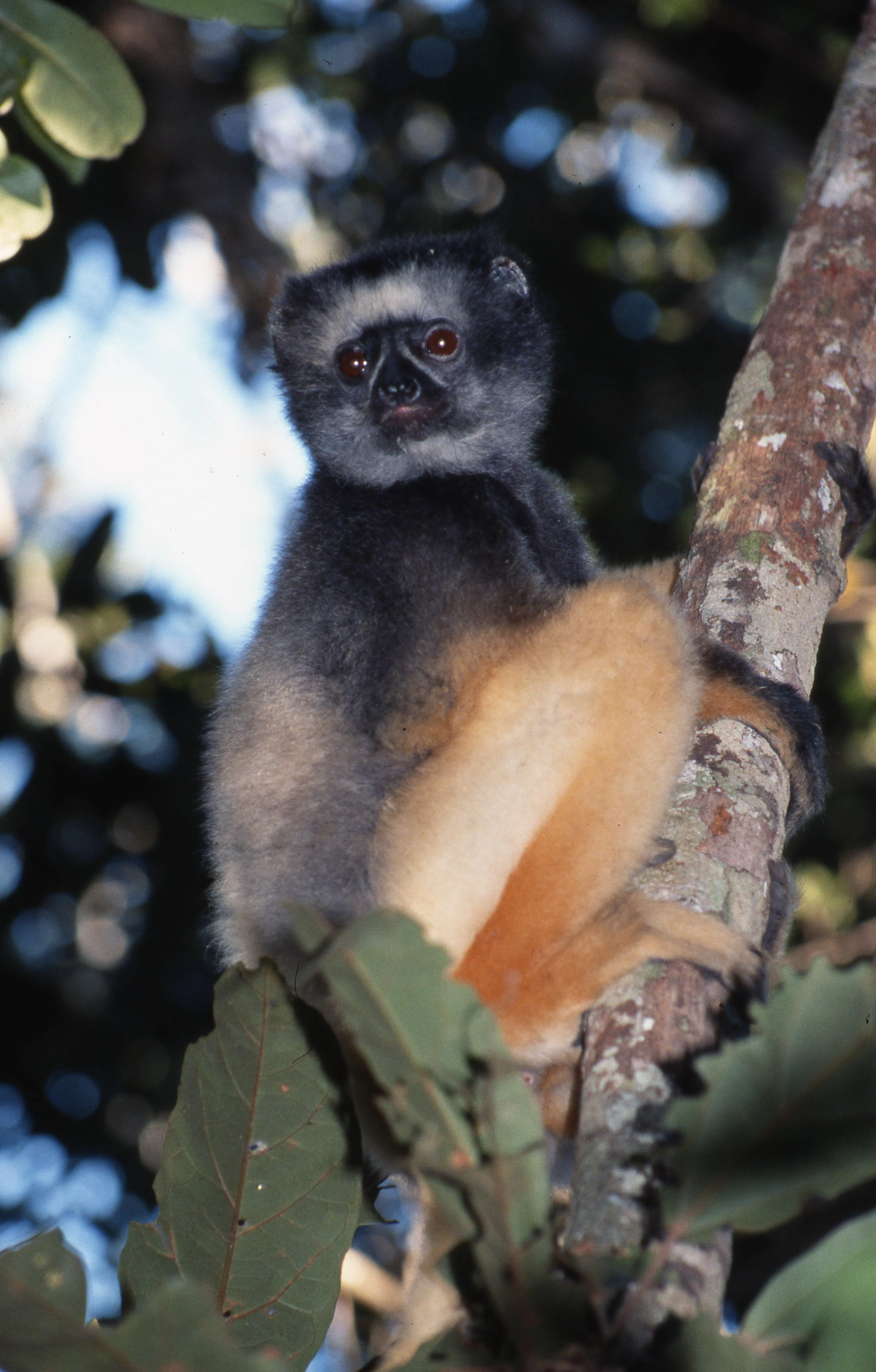
A Diademed Sifaka lemur with grey fur on its head and chest and orange-yellow fur on its limbs, perched on a tree branch.
A Diademed Sifaka resting in a tree within the Betampona Reserve.

Réserve naturelle intégrale de Betampona history and protected-area timeline

Betampona holds a special place in the history of Madagascar's protected-area system. It was created by decree on 30 December 1927, making it the country's very first integral nature reserve, an early formal recognition that Madagascar's eastern forests harbored biodiversity worthy of the strictest form of protection. Its legal status was later clarified and reinforced by decree number 66-242 of 1 June 1966.

For many decades the reserve was administered through the Eaux et Forêts (Waters and Forests) service of Toamasina, the regional forestry authority of the eastern coast. During this period it developed a close working relationship with the Ivoloina forestry station, which shared responsibility for conservation and forestry matters in the region. This long institutional history gave Betampona continuity of protection at a time when much of the surrounding lowland forest was being cleared for agriculture.

In 1996, management of the reserve was transferred to Madagascar National Parks, which now oversees the site in partnership with the Madagascar Fauna and Flora Group, a non-governmental organization. This transfer marked a shift toward more active, science-based conservation, including long-term monitoring of lemurs, birds, and other forest species, and the development of partnerships with neighboring communities through structures such as Local Park Committees (CLPs) and Support and Orientation Committees for Protected Areas (COSAPs).

Réserve naturelle intégrale de Betampona landscape and geographic character

The landscape of Betampona is shaped by a steep forested massif that rises out of the broader agricultural lowlands of the eastern coast. Visitors and researchers encounter a terrain of hills, ridges, and narrow valleys, often with sharp slope breaks and abrupt contours. The reserve's elevations mostly cluster between roughly 250 and 500 meters, with the highest points reaching close to 590 meters, while the lowest areas dip to around 275 meters.

The topography is dissected by a dense network of small streams that descend rapidly from the forest interior toward the surrounding lowlands. Twelve rivers flow permanently through the reserve, fed by seepage and runoff from the saturated forest soils. Their flow is torrential in character, swelling suddenly after heavy rains and carving small ravines and gullies into the slopes. The result is a constantly humid forest environment, with persistent mist, dripping canopy, and saturated leaf litter.

The ridge line of Vohitsara acts as the defining geographical landmark of the reserve. It forms the main watershed divide, separating the northern slopes, whose waters flow toward the Ifontsy River, from the southern slopes, which drain into the Ivoloina system. From these forested heights, the surrounding agricultural plain extends in every direction, creating a striking visual contrast between the dark green forest cover of Betampona and the patchwork of cleared land that presses against its borders.
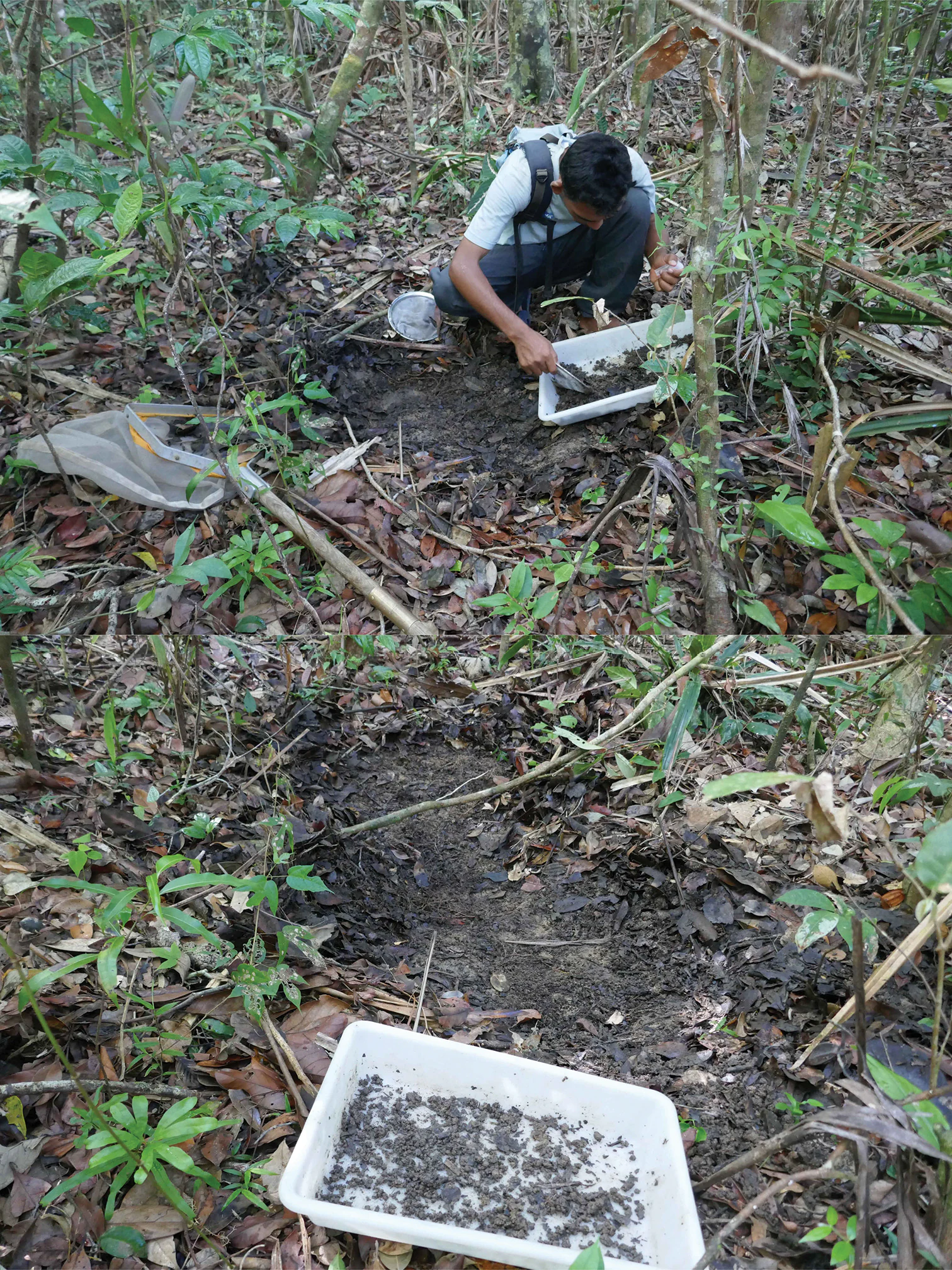
A person crouching on a forest floor, using a small white tray to collect soil or leaf litter samples in a tropical environment.
A researcher conducting biological fieldwork in the dense rainforest of Betampona Reserve.

Réserve naturelle intégrale de Betampona ecosystems, habitats, and plant life

Betampona protects one of the last sizeable fragments of lowland humid evergreen rainforest along Madagascar's eastern coast, an ecosystem that has largely disappeared elsewhere on the island due to clearing for shifting cultivation. Within its compact area, the reserve holds an exceptional concentration of plant diversity, including around 807 recorded species of vascular plants.

The flora is dominated by three large plant families that are typical of Malagasy humid forests: Euphorbiaceae, Rubiaceae, and Fabaceae. The reserve is particularly notable for its palms, which count twenty-six endemic species, including Dypsis betamponensis, a palm found nowhere else in the world, and the striking Dypsis tsaravoasira. Epiphytic plants such as the bird's nest fern, Asplenium nidus, are characteristic of the moist, shaded canopy environment. Betampona is also home to a wild relative of coffee, Coffea betamponensis, named for the reserve itself.

Ecologically, the humid evergreen forest of Betampona functions as a continuous canopy system in which large trees, palms, ferns, and epiphytes form a multilayered habitat. The forest's permanent streams, deep leaf litter, and stable humidity create a rich set of microhabitats that support unusually dense populations of moisture-dependent species, from amphibians clinging to stream banks to lemurs foraging in the upper canopy.

Réserve naturelle intégrale de Betampona wildlife and species highlights

Wildlife is the heart of Betampona's conservation value. The reserve is home to eleven primate species, an unusually high figure for such a small area, and is especially important for Madagascar's emblematic lemurs. Among them are the indri, famous for its haunting calls and its complete dependence on continuous canopy forest, and the diademed sifaka, both of which are listed on the IUCN Red List of threatened species. The reserve also harbors the black-and-white ruffed lemur and the white-fronted lemur, both highly arboreal species that play essential roles in seed dispersal and in maintaining the structure of the forest.

The herpetofauna of Betampona is similarly rich and uniquely Malagasy. Numerous reptile and amphibian species are endemic to the area, many of them tied to specific microhabitats such as forest streams, fallen logs, and the wet leaf-litter layer. Their dependence on stable humidity makes Betampona's continuous moist canopy particularly important for their long-term survival.

The reserve is also a significant site for forest birds. The avifauna includes brightly colored species such as the blue vanga, recognizable for its vivid blue plumage and robust bill, along with several coua species including the running coua of Serres and the crested coua. Other characteristic birds include the Malagasy coucal, the Madagascar nightjar, the grey-headed lovebird, and the brown mesite, a ground-dwelling species considered ecologically unique. The Malagasy cuckoo also occurs in the reserve. Together, this fauna positions Betampona as a key refuge for species that have become increasingly rare elsewhere in Madagascar's fragmented eastern forests.

Réserve naturelle intégrale de Betampona conservation status and protection priorities

As an integral nature reserve classified under the strictest IUCN category, Ia, Betampona represents one of the highest levels of protection available in Madagascar, with human activity inside its boundaries tightly restricted. Its conservation significance is amplified by the fact that surrounding lowland forests have been almost entirely converted, leaving Betampona as one of the last refuges for the species that once occupied a much wider landscape.

The reserve is managed by Madagascar National Parks in partnership with the Madagascar Fauna and Flora Group, an organization that has conducted long-term research and conservation programs at the site for many years. Their work combines scientific monitoring of lemurs, birds, amphibians, and plants with efforts to restore degraded areas and to engage surrounding villages in the protection of the forest.

Conservation at Betampona is also a community endeavor. Through participatory structures known as Local Park Committees (CLPs) and Committees for the Orientation and Support of Protected Areas (COSAPs), neighboring communities are directly involved in surveillance, environmental education, and sustainable resource management. This collaborative model is central to the reserve's long-term prospects, given that its main threats, including slash-and-burn agriculture, fuelwood collection, hunting, habitat fragmentation, and the broader pressures of climate change, all originate beyond the reserve's formal boundary.

Réserve naturelle intégrale de Betampona cultural meaning and human context

Betampona lies within a long-settled agricultural landscape on Madagascar's eastern coast, where rural communities have farmed rice, gathered forest products, and practiced shifting cultivation, locally known as tavy, for generations. The reserve's borders are pressed against villages and farmland, which has shaped both the threats it faces and the conservation strategies used to protect it.

Recognizing this tight relationship between people and forest, the reserve's management has emphasized community-based conservation. Through local committees and partnerships with neighboring communes, villagers participate in monitoring, environmental education, and sustainable-use initiatives. Betampona thus sits at the meeting point between modern biodiversity conservation and a long-standing rural Malagasy cultural relationship with the eastern rainforest.

Top sights and standout views in Réserve naturelle intégrale de Betampona

Madagascar's very first integral nature reserve, established in 1927 and protected under the strictest IUCN category.

One of the last surviving well-preserved fragments of lowland humid evergreen forest along Madagascar's eastern coast.

A refuge for eleven primate species, including the indri, the diademed sifaka, and the black-and-white ruffed lemur.

Exceptional botanical diversity, including twenty-six endemic palm species and the reserve-endemic Dypsis betamponensis.

A key site for endemic amphibians, reptiles, and forest birds, supported by twelve permanent rivers and a constantly humid microclimate.

Best time to visit Réserve naturelle intégrale de Betampona

The climate of eastern Madagascar is hot, humid, and rainy throughout much of the year, and Betampona does not have a sharply distinct dry season like parts of western Madagascar. Conditions are somewhat drier during the cooler months roughly between May and October, when the heaviest rains ease off and forest trails are more easily walked and wildlife observation tends to be more comfortable.

During the warmer, wetter months from about November to April, the forest is at its most lush and humid, with the canopy in full leaf and streams at their highest flow. This period can be spectacular for observation of amphibians and lemur activity, but it also brings heavier rainfall, muddy trails, and greater heat and humidity for visitors.
Monthly climate preview

Annual temperature ranges and precipitation rhythms across representative coordinate data

Réserve naturelle intégrale de Betampona Climate and Temperature Normals

Representative coordinates record measured monthly temperature swings from 20.85 to 25.99 degrees Celsius alongside seasonal daily precipitation variations ranging between 1.87 and 10.33 millimeters. Examining the complete twelve-month climatology profile reveals precise long-term trends across the protected landscape.
Annual mean24 °C
21 °C26 °C
Jan26°
Feb26°
Mar26°
Apr25°
May24°
Jun22°
Jul21°
Aug21°
Sep21°
Oct23°
Nov24°
Dec25°
Warmest month
February

26 °C

Coolest month
August

20.9 °C

Wettest month
February

10.3 mm/day

Driest month
September

1.9 mm/day

Park location guide

Geography guide, regional context, and park location map for Réserve naturelle intégrale de Betampona

Réserve naturelle intégrale de Betampona park geography, regions, and map view in Madagascar

Understand where Réserve naturelle intégrale de Betampona sits in Madagascar through a broader geographic reading of the surrounding landscape, nearby location context, and its mapped position within the national park landscape.

How Réserve naturelle intégrale de Betampona fits into Madagascar

Madagascar is an island nation in the Indian Ocean, positioned off the southeastern coast of Africa. As the world's fourth-largest island and second-largest island country, it stands out for its exceptional biodiversity, over 90% of its wildlife is endemic, making it one of 17 megadiverse countries. The population is approximately 32 million, with Antananarivo as both the capital and largest city.

Wider geography shaping Réserve naturelle intégrale de Betampona in Madagascar

Madagascar lies in the Indian Ocean off the southeastern coast of Africa, separated from the mainland by the Mozambique Channel. The island is situated approximately 400 km from the African continent. As the world's fourth-largest island, it also includes numerous smaller peripheral islands.

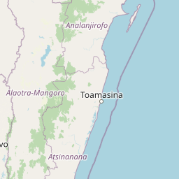
Map view of Réserve naturelle intégrale de Betampona

Use this park location map to pinpoint Réserve naturelle intégrale de Betampona in Madagascar, understand its exact geographic position, and read its mapped placement within the surrounding landscape more clearly.

Pigeon | © OpenStreetMap contributors

Location context for Réserve naturelle intégrale de Betampona

Analanjirofo

Visual reference of lowland rainforest habitats and steep forest terrain

Réserve naturelle intégrale de Betampona Photos and Landscape Scenery

Photographs capture the steep forested massif, dense river networks, and humid evergreen canopy that define the protected landscape of Réserve naturelle intégrale de Betampona. Detailed visual documentation helps researchers and conservationists examine the terrain, canopy structure, and environmental isolation of Madagascar's historic eastern nature reserve.

A Diademed Sifaka lemur with grey fur on its head and chest and orange-yellow fur on its limbs, perched on a tree branch.

An Indri lemur with black and white fur sits in a tree, looking back at the camera.

A person crouching on a forest floor, using a small white tray to collect soil or leaf litter samples in a tropical environment.

Park atlas

Compare regional rainforest reserves and adjacent protected areas across the eastern coast of Madagascar

Exploring Parks Near Réserve naturelle intégrale de Betampona and Surrounding Protected Landscapes

Browse adjacent forest reserves and regional protected areas that share ecological traits with Réserve naturelle intégrale de Betampona. Comparing nearby rainforest habitats provides broader context for understanding the conservation challenges facing eastern Madagascar.
Wildlife reserveAtsinanana
About 48 km away#1 closest

Southwest

Réserve spéciale de Mangerivola: Geographic Overview of an Atsinanana Wildlife Reserve

Rainforest topography and protected corridor mapping

Réserve spéciale de Mangerivola serves as a cornerstone of the eastern Malagasy rainforest corridor. This overview provides insight into the reserve's challenging, roadless terrain and its layered ecological composition, ranging from dense humid forests to rocky, high-altitude outcrops that sustain rare bird species and seven distinct lemur populations.

Area
130.05 km²
Established
1958
IUCN
IV
Relief
Upland
National parkMadagascar
About 51 km away#2 closest

West

Zahamena National Park: Madagascar National Park Exploration and Geographic Context

Mapping the protected boundaries and landscape of Zahamena National Park.

Delve into Zahamena National Park, a vital protected territory situated in Madagascar. This national park offers a unique perspective on the island's natural geography and its status as a significant protected landscape. Understand its position within Madagascar's broader context, focusing on the mapped aspects of its protected area identity and its contribution to the country's renowned biodiversity hotspot status.

Area
423 km²
Established
1997
IUCN
II
Relief
Mountain
Nature reserveAlaotra-Mangoro
About 55 km away#3 closest

West

Ankeniheny-Zahamena Corridor: Nature Reserve Landscape and Regional Geography

Mapping the central rainforest belt of the Alaotra-Mangoro region

Spanning over 3,800 square kilometers, the Ankeniheny-Zahamena Corridor stands as a cornerstone of Malagasy conservation. This reserve integrates diverse humid forest habitats into a single functioning landscape, providing a critical haven for endemic flora and threatened primates. Its role as a major watershed catchment reinforces its environmental importance for surrounding communities across eastern and western Madagascar.

Area
3,810 km²
Established
2007
IUCN
VI
Relief
Mixed relief
Protected landscapeAlaotra-Mangoro
About 88 km away#4 closest

Northwest

Lake Alaotra Protected Landscape: Atlas and Geographic Wetland Profile

Mapping the primary wetland basin of Madagascar's Alaotra-Mangoro region.

Lake Alaotra serves as a central protected landscape within the Alaotra-Mangoro region, featuring an extensive system of marshes, reedbeds, and freshwater zones. This profile offers a structured look at the lake's geography, its role as a critical wetland habitat, and the surrounding terrain that shapes this important Madagascar catchment area.

Area
7,223 km²
Relief
Lowland
Scope
Terrestrial
Water
Water-dominated
Watercolor illustration of a landscape featuring mountains, a lake, trees, and pink flowers in the foreground
National parkAlaotra-Mangoro
About 143 km away#5 closest

Southwest

Analamazaotra National Park: Protected Rainforest Ecosystem and Mapped Landscape in Alaotra-Mangoro

Explore Madagascar's Eastern Highlands protected area geography.

Analamazaotra National Park, situated in Madagascar's Alaotra-Mangoro region, represents a critical segment of the island's protected eastern rainforests. This national park is mapped as a vital conservation area, offering insights into its unique ecosystems and natural terrain. Understanding Analamazaotra National Park's geographic placement and protected boundaries provides essential context for regional landscape exploration and atlas-based geographic discovery within Madagascar.

Area
26.53 km²
Established
2015
IUCN
II
Relief
Highland
National parkAlaotra-Mangoro
About 144 km away#6 closest

Southwest

Andasibe-Mantadia National Park: National Park and Protected Landscape Identity

Explore its mapped boundaries and geographic context.

Andasibe-Mantadia National Park is a distinct protected territory within the Alaotra-Mangoro region, serving as a crucial focal point for understanding Madagascar's regional geography and protected land distribution. This detail page provides essential atlas-style information on the park's mapped area and its natural landscape characteristics. Engage with structured data that highlights the park's protected status and its position within the broader geographic framework of eastern Madagascar, supporting focused discovery for researchers and explorers.

Area
155 km²
Established
1989
IUCN
II
Visitors
26.1K annual
National parkMadagascar
About 144 km away#7 closest

Southwest

Mantadia National Park: Madagascar National Park and Protected Landscape Atlas

Mapped boundaries and regional geographic context of Mantadia.

Mantadia National Park represents a crucial protected landscape within Madagascar, detailed here for comprehensive geographic and atlas exploration. This entry focuses on its identity as a national park, providing insights into its mapped boundaries and its contribution to the understanding of Madagascar's diverse natural terrain. The information facilitates a structured discovery of the park's environmental and geographical significance, essential for anyone mapping protected areas.

Wildlife reserveAlaotra-Mangoro
About 145 km away#8 closest

Southwest

Analamazaotra Forest Station: Protected Rainforest Landscapes in Alaotra-Mangoro, Madagascar

Community-managed wildlife reserve and humid forest habitat

Analamazaotra Forest Station represents a core protected area within the humid eastern rain forests of Madagascar. Managed through local partnership, the reserve functions as a hub for habitat restoration and biodiversity conservation. This site is integral to the regional landscape, preserving a continuous block of essential forest habitat along the eastern escarpment that supports a wide range of endemic species.

Area
7.1 km²
Relief
Upland
Climate
Tropical
Access
Access unknown

Common questions about visiting, size, designation, and location context for Réserve naturelle intégrale de Betampona

Réserve naturelle intégrale de Betampona FAQs for park facts, access, geography, and protected area context

Find quick answers about Réserve naturelle intégrale de Betampona, including protected-area facts, park geography, trail and visitor context, and how the park fits into its surrounding country and regional landscape.
MoriAtlas Explorer

Continue Your Protected Areas Search Across the Global Atlas

Deepen your exploration by continuing the structured search for national parks and protected areas worldwide. Utilize the comprehensive filtering capabilities to compare different conservation landscapes and refine your understanding of global park geography. Discover more about the distribution and characteristics of protected natural areas.

Global natural geography