
Mori Atlas logo
Nature reserveRéserve naturelle régionale de la boucle de Moisson

Discover the mapped terrain, woodland, and open plains of this regional nature reserve

Réserve naturelle régionale de la boucle de Moisson: A Protected Seine River Meander Landscape

The Réserve naturelle régionale de la boucle de Moisson preserves a distinctive meander of the Seine river within the Yvelines department of Île-de-France. This protected area features a mosaic of river-edge habitats, open plains, and birch woodlands that change character with the seasons. The site offers a clear view of river-carved geography and serves as a vital corridor for landscape continuity in the western Paris basin.

regional nature reserveSeine meanderriver landscapefloodplainwoodlandbirch forest
Stylized digital illustration of a valley at sunset, framed by coniferous trees in the foreground, with distant mountains and a small structure visible on a hillside.

Réserve naturelle régionale de la boucle de Moisson

Nature reserve

Park overview

Structured park overview, official facts, and landscape profile for Réserve naturelle régionale de la boucle de Moisson

Réserve naturelle régionale de la boucle de Moisson park facts, protected area profile, and essential visitor context

Review the core facts for Réserve naturelle régionale de la boucle de Moisson, including designation, size, terrain, visitor scale, habitats, and operating context in one park-focused overview.

About Réserve naturelle régionale de la boucle de Moisson

The Réserve naturelle régionale de la boucle de Moisson is a regional nature reserve situated in Île-de-France, in north-central France. It is anchored to one of the most visible meanders of the Seine, a wide, looping curve that the river carves through the countryside of the Yvelines. The reserve's territory follows that curve, capturing the diversity of natural environments that the river and its floodplain have created over time.

Although the reserve lies within the broader metropolitan orbit of Paris, its setting is surprisingly rural. The Yvelines department, west of the capital, still contains stretches of countryside, agricultural plains, woodlots, and river valleys that contrast with the dense urban fabric further east. Within this setting, the Boucle de Moisson highlights the role of large rivers as landscape architects: the Seine's meander has shaped soils, microclimates, vegetation patterns, and historical land use across centuries.

The reserve belongs to the Regional Nature Reserves of France network (Réserves naturelles régionales), a category of voluntary, regionally created protected areas intended to preserve locally significant natural heritage. Management is delegated to the Agence des espaces verts de la région d'Île-de-France, the regional agency responsible for stewardship of public green estates and nature reserves in Île-de-France. This institutional setup means the reserve functions both as a conservation site and as a regionally held property with educational and discovery value.

For visitors and residents, the Boucle de Moisson represents an accessible example of the river-meander landscape that defines so much of the upper Seine valley. It is a place where a short walk can move from open vantage-point views over the plain, into sidling birch woodland, and toward the river's edge, illustrating how a single meander can pack multiple natural environments into a compact footprint.

Quick facts and research context for Réserve naturelle régionale de la boucle de Moisson

The Boucle de Moisson is a French regional nature reserve located in the Yvelines department, within the Île-de-France region. It sits inside a large meander of the Seine river, on land belonging to the communes of Moisson and Mousseaux-sur-Seine. The reserve was officially established by regional deliberation on 9 July 2009, and its parcel list was revised by a further deliberation on 21 November 2012.

It is administered by the Agence des espaces verts de la région d'Île-de-France, the regional body responsible for managing the green estates of the Île-de-France region. The reserve is classified as a regional nature reserve and corresponds to IUCN Category IV. The site is recorded in international databases such as the World Database on Protected Areas.

Protection and recognition

Documented protection history, official designations, and international database records

Réserve naturelle régionale de la boucle de Moisson Protection Status and Recognition

Protected area records for Réserve naturelle régionale de la boucle de Moisson compile verified conservation status and formal designation history. Atlas data sources provide structured conservation metrics for geographic research and ecological evaluation.

Protection details

WDPA ID
555514372
Park context

Deeper park guide and search-rich context for Réserve naturelle régionale de la boucle de Moisson

Réserve naturelle régionale de la boucle de Moisson history, landscape, wildlife, and travel context

Explore Réserve naturelle régionale de la boucle de Moisson through its history, landscape character, ecosystems, wildlife, conservation priorities, cultural context, and seasonal travel timing in a structured park guide built for atlas discovery and search intent.

Why Réserve naturelle régionale de la boucle de Moisson stands out

The reserve is most notable for its position within a prominent meander of the Seine, where the river loops through the rural landscape of the western Yvelines. This river-bend setting defines the entire character of the protected area, giving it its name and providing the structural backbone for its habitats. Within that looped river landscape, the reserve is also recognised for preserving an open plain-like environment, accessible viewpoints over the surrounding countryside, and a mosaic of seasonal landscapes ranging from summer meadows to birch woods dressed in autumn colour. The combination of river meander, open ground, and sidling woodland is what makes the Boucle de Moisson visually and ecologically distinct among regional nature reserves in the Île-de-France.
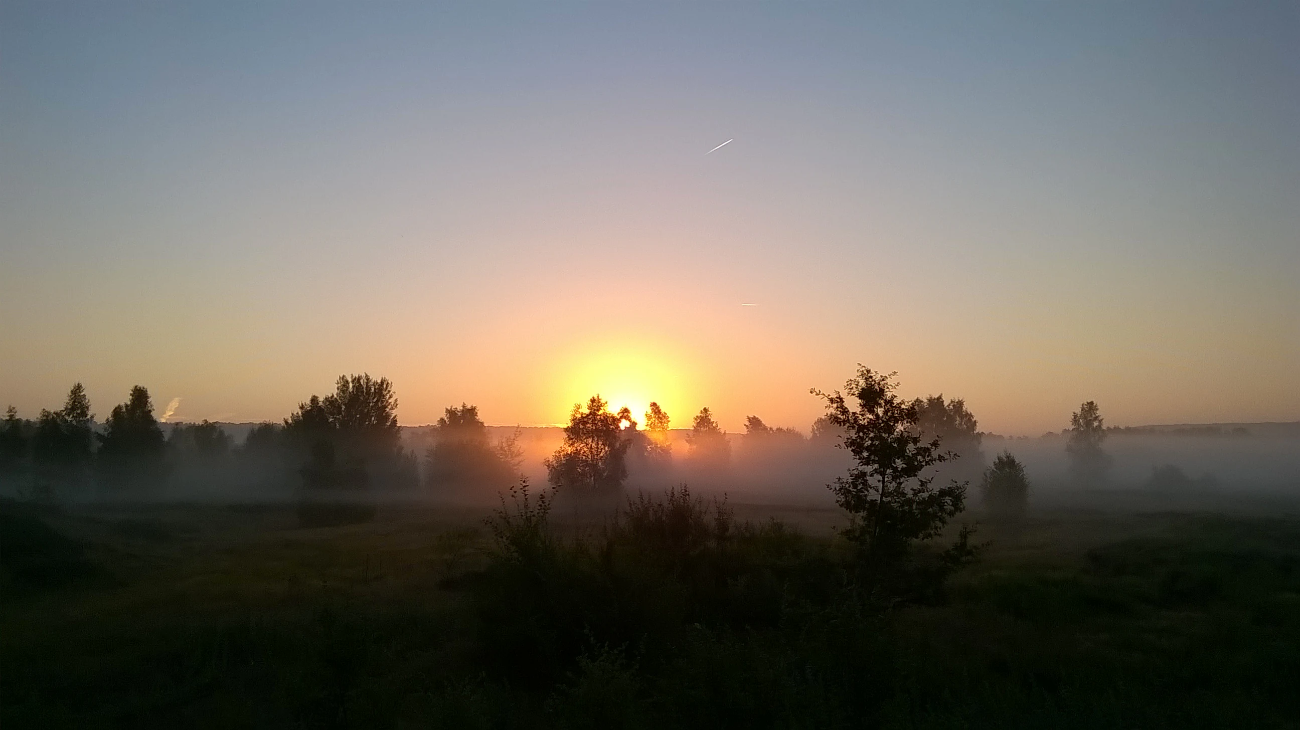
A hazy landscape of trees and fields at sunrise, with the sun low on the horizon casting a golden glow through morning mist.
Sunrise over the Réserve naturelle régionale de la boucle de Moisson.

Réserve naturelle régionale de la boucle de Moisson history and protected-area timeline

The modern history of the site begins on 9 July 2009, when a regional deliberation formally created the Réserve naturelle régionale de la boucle de Moisson. By that act, the Île-de-France region brought the Seine meander into the network of regional nature reserves, giving it legal protection and assigning its management to the Agence des espaces verts de la région d'Île-de-France. A later deliberation, on 21 November 2012, adjusted the list of parcels included in the reserve, refining the boundary and the composition of the protected land.

Beyond its recent conservation history, the landscape itself has an older human story. A portion of the area hosted the Jamboree mondial de 1947, the World Scout Jamboree held that year, which brought more than 24,000 scouts from 48 countries to what was then a temporary gathering ground. While the event was ephemeral, it underlines the long-standing openness of the site to large-scale communal use before it became a dedicated nature reserve.

Ornithological monitoring work carried out by CORIF and recorded in 2004 documents early scientific interest in the reserve's birdlife, particularly as part of monitoring the regional properties administered by the Agence des espaces verts. This work helped build the ecological case for formal protection and underpinned the subsequent classification of the site as a regional nature reserve.

Réserve naturelle régionale de la boucle de Moisson landscape and geographic character

The defining feature of the Boucle de Moisson is its setting within a large meander of the Seine. The river curves around the reserve, shaping both its outer extent and the quieter inside curve on which much of the protected land sits. This riverine geometry gives the landscape its gentle, enclosed character, with views framed by the wider plain on one side and the closeness of the river and its slopes on the other.

The terrain itself combines open ground with sidling woodland. Across the plain, expansive horizons open up: low vegetation, fallow land, and grassy stretches that, in winter, produce wide views towards distant edges of the meander. As the eye moves towards the slopes and fringes of the bend, the landscape becomes more textured, with patches of scrub, coppice-like woodland, and softer transitions into the river's edge. Birches appear in several parts of the reserve, contributing strongly to the seasonal palette and turning the woodland into a display of autumn colour in the cooler months.

Seasonal variation is a striking element of the landscape here. Winter brings openness and broad, soft views, suitable for observing the overall shape of the meander. Summer favours the dense greens of the plain and the woodland, while autumn transforms the birches and mixed vegetation into rusts and yellows. The combination of river curve, plain, and woodland edge creates a layered scene in which each visit, even at the same vantage point, can feel distinctly different.
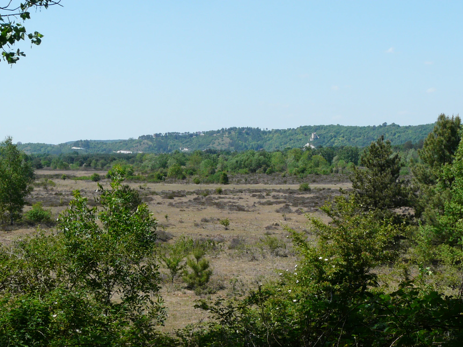
A wide view of an open moorland plain with low scrubby vegetation, framed by trees in the foreground, with forested hills in the distant background under a clear sky.
A view of the moorland plains and rolling hillsides characteristic of the Seine valley in the Réserve naturelle régionale de la boucle de Moisson.

Réserve naturelle régionale de la boucle de Moisson ecosystems, habitats, and plant life

The ecological identity of the Boucle de Moisson is directly tied to its river-meander setting. The Seine's looping course creates a mix of floodplain-influenced soils, drier slopes, and transitional zones that support varied plant communities within a relatively small footprint. This mosaic of habitats is one of the main reasons the site merited formal regional protection.

Vegetation associated with open plain environments is visible across the reserve, alongside more developed woodland patches. The presence of birches, in particular, suggests a mosaic capable of supporting both pioneer tree species and more established woodland types. The mix of grassy open ground, scrub transitions, and wooded slopes offers a gradient of light, moisture, and soil conditions, which in turn can sustain a wider range of organisms than any single habitat type would support alone.

For a regional nature reserve in Île-de-France, the value of the Boucle de Moisson lies less in any single dramatic ecosystem and more in the continuity of habitats it preserves within a working agricultural and riverine landscape. The reserve helps anchor the local ecological network and offers natural space amid a region otherwise dominated by farmland and suburban growth.
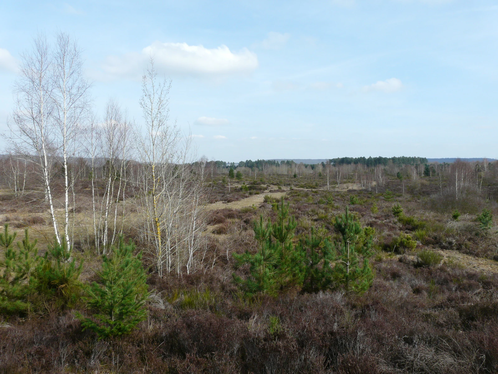
A wide, slightly elevated landscape view of a sparsely wooded area with white-barked birch trees and low-lying shrubs under a clear blue sky during winter.
A winter view overlooking the heathland and birch trees within the Réserve naturelle régionale de la boucle de Moisson.

Réserve naturelle régionale de la boucle de Moisson wildlife and species highlights

Although detailed species inventories are not formally developed in the available source material, available references make clear that birdlife is significant to the reserve. Ornithological monitoring by CORIF was carried out at the site ahead of its formal classification, treating the Boucle de Moisson as one of the regional estate properties whose bird communities were worth systematic survey.

This focus on birds is consistent with the wider ecology of Seine meanders: open ground, scrub, woodland edges, and river proximity tend to support a mix of breeding and migratory species, with different habitats attracting different guilds across the year. The combination of plain, woodland, and river edge in such a compact area makes the Boucle de Moisson a meaningful local site for birdwatching and seasonal observation.

The reserve's broader role for fauna is tied to habitat continuity. By protecting a continuous block of varied habitat along the Seine, the reserve helps maintain conditions for small mammals, invertebrates, reptiles, and amphibians typical of the mixed open-and-wooded landscapes of the Yvelines, even where confirmatory species lists are not yet formalized in available documentation.
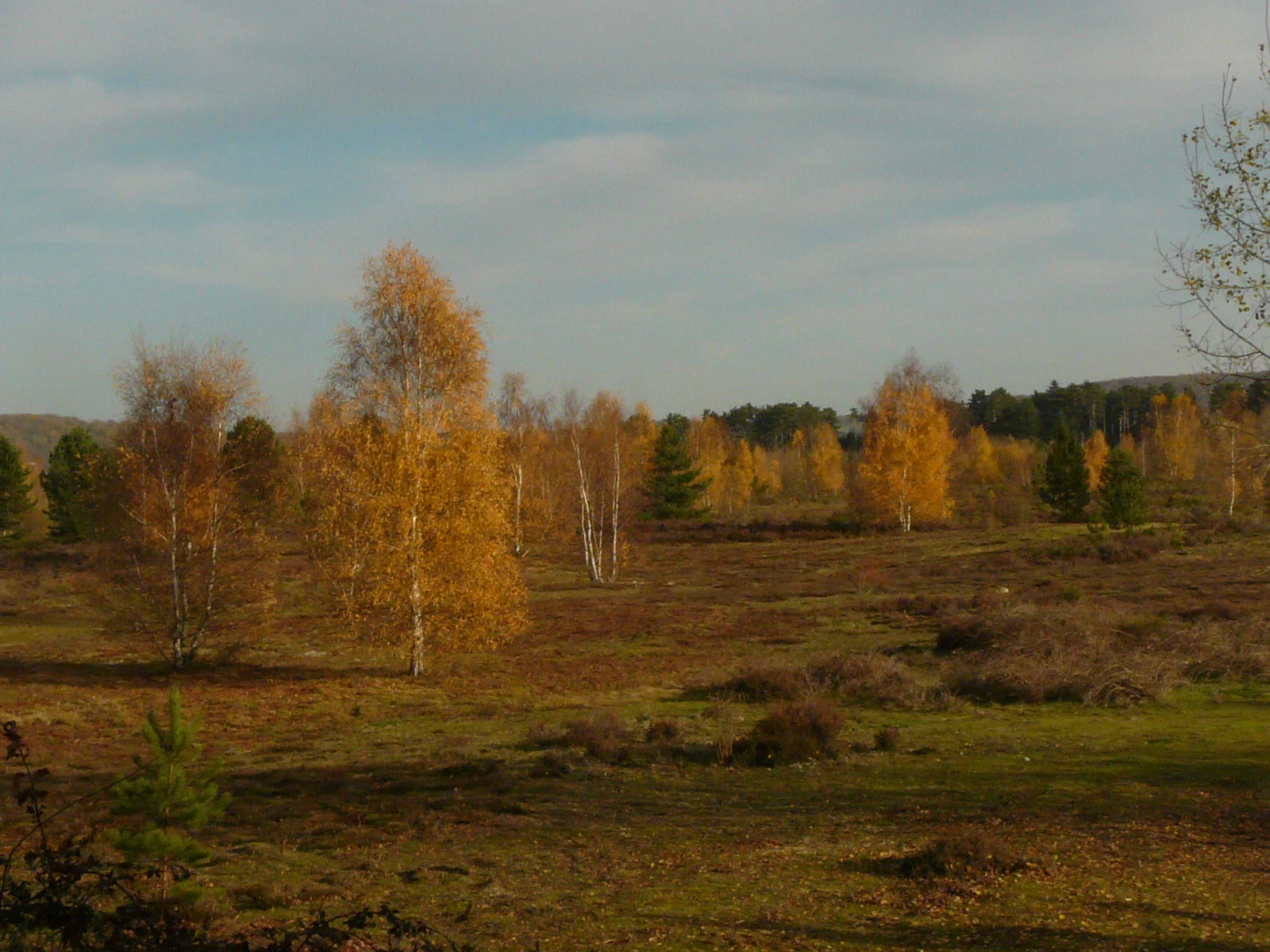
A meadow filled with scattered birch trees displaying golden autumn leaves under a cloudy sky.
Birch trees in autumn foliage within the natural environment of the Réserve naturelle régionale de la boucle de Moisson.

Réserve naturelle régionale de la boucle de Moisson conservation status and protection priorities

The Boucle de Moisson's principal conservation significance lies in the protection of a representative segment of the Seine's meander landscape in the western Yvelines. Large river meanders are increasingly rare in densely populated regions of France, and the regional nature reserve status places the site under a durable legal framework intended to maintain its character over the long term.

Classified as a regional nature reserve in 2009, the site is part of a network of voluntary regional protections across France that complement national parks and other stricter categories. It is also documented internationally under IUCN Category IV, recognising its role in the conservation of habitats and species through active management of the landscape.

Management is entrusted to the Agence des espaces verts de la région d'Île-de-France, bringing the reserve within a coordinated regional approach to green estates and nature reserves. This includes ongoing ornithological work, public discovery, and the gradual definition of the site's ecological priorities, anchored by an initial parcel list that was refined in 2012 to better reflect the boundaries of the protected area.

Réserve naturelle régionale de la boucle de Moisson cultural meaning and human context

The cultural footprint of the Boucle de Moisson is relatively understated today, but the site carries a notable moment of twentieth-century social history. A part of its grounds served as the venue for the Jamboree mondial de 1947, a major international Scout gathering that hosted more than 24,000 participants from 48 countries on the eve of the post-war period.

The landscape also reflects the broader identity of the Yvelines: a department shaped historically by the Seine valley, agriculture, and proximity to the French capital. The reserve sits at the rural edge of that metropolitan system, linking everyday regional life with the wider heritage of the Seine as both a natural and cultural artery of northern France.

Top sights and standout views in Réserve naturelle régionale de la boucle de Moisson

A large and visually clear Seine meander at the heart of the reserve, offering a textbook example of how a major river carves the surrounding landscape. Open plain vistas, particularly striking in winter, that allow visitors to grasp the full shape of the bend. A woodland component rich in birch, giving the reserve a strong seasonal character and notable autumn colour. Layered habitats moving from open ground through scrub to wooded slopes, all within a compact 316-hectare footprint. Membership of the French network of regional nature reserves and management by the Agence des espaces verts de la région d'Île-de-France, providing both legal protection and a coordinated regional stewardship context. A small but tangible piece of twentieth-century social history, with the site having hosted the 1947 World Scout Jamboree.

Best time to visit Réserve naturelle régionale de la boucle de Moisson

The Boucle de Moisson rewards visits in every season, but the character of the landscape shifts noticeably through the year. Winter is best for appreciating the wider geometry of the Seine meander, with open plain views revealing the curve of the river and the broader shape of the protected area. The bare branches also open up long sightlines and a quiet, contemplative atmosphere.

Spring and summer bring the dense greens of the plain and the woodland, softening the landscape and producing a richer sense of enclosed habitat. This is a good time for walking, listening to birdlife, and appreciating the mixed vegetation of the slopes and fringes of the meander.

Autumn is arguably the most visually distinctive season at the Boucle de Moisson. The birch and mixed woodland turn warm yellows and reds, layering colour onto the river-meander scene and making seasonal photography or slow walks particularly rewarding.
Monthly climate preview

Long-term representative monthly averages for temperature and precipitation patterns

Climate Normals and Annual Temperature Rhythm for Réserve naturelle régionale de la boucle de Moisson

Representative coordinates record mean monthly temperatures spanning from 3.11 degrees Celsius to 18.79 degrees Celsius alongside daily precipitation between 1.54 millimeters and 2.39 millimeters. Examining the full twelve-month profile provides complete historical averages across the entire protected territory.
Annual mean11 °C
3 °C19 °C
Jan
Feb
Mar
Apr10°
May13°
Jun17°
Jul19°
Aug19°
Sep15°
Oct11°
Nov
Dec
Warmest month
July

18.8 °C

Coolest month
January

3.1 °C

Wettest month
December

2.4 mm/day

Driest month
April

1.5 mm/day

Park location guide

Geography guide, regional context, and park location map for Réserve naturelle régionale de la boucle de Moisson

Réserve naturelle régionale de la boucle de Moisson park geography, regions, and map view in France

Understand where Réserve naturelle régionale de la boucle de Moisson sits in France through a broader geographic reading of the surrounding landscape, nearby location context, and its mapped position within the national park landscape.

How Réserve naturelle régionale de la boucle de Moisson fits into France

France is a unitary semi-presidential republic and one of the world's largest economies. It borders Belgium, Luxembourg, Germany, Switzerland, Italy, Monaco, Andorra, and Spain, with a maritime border to the United Kingdom. The country is known for its cultural influence, art, cuisine, and political history spanning centuries.

Wider geography shaping Réserve naturelle régionale de la boucle de Moisson in France

France is located in Western Europe. Metropolitan France extends from the Rhine to the Atlantic Ocean and from the Mediterranean Sea to the English Channel and North Sea. The country borders Belgium, Luxembourg, Germany, Switzerland, Italy, Monaco, Andorra, Spain, and has a maritime border with the United Kingdom.

Map view of Réserve naturelle régionale de la boucle de Moisson

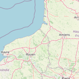
Use this park location map to pinpoint Réserve naturelle régionale de la boucle de Moisson in France, understand its exact geographic position, and read its mapped placement within the surrounding landscape more clearly.

Pigeon | © OpenStreetMap contributors

Location context for Réserve naturelle régionale de la boucle de Moisson

Île-de-France

Visual exploration of river meanders, plain terrain, and woodland habitats

Réserve naturelle régionale de la boucle de Moisson Photos and Scenery

Visual records capture the distinctive river meander, open plain terrain, and birch woodlands defining Réserve naturelle régionale de la boucle de Moisson. Exploring these protected landscapes reveals seasonal shifts across the valley and the ecological structure of the regional reserve.

A hazy landscape of trees and fields at sunrise, with the sun low on the horizon casting a golden glow through morning mist.

A hazy, golden-hued sunrise illuminating a field with scattered trees and low-lying ground mist.

A wide view of an open moorland plain with low scrubby vegetation, framed by trees in the foreground, with forested hills in the distant background under a clear sky.

A wide, slightly elevated landscape view of a sparsely wooded area with white-barked birch trees and low-lying shrubs under a clear blue sky during winter.

A meadow filled with scattered birch trees displaying golden autumn leaves under a cloudy sky.

A forest clearing surrounded by dense pine trees in the foreground, with deciduous trees showing autumn yellow foliage in the middle distance.

Park atlas

Compare nearby river valley reserves and surrounding protected landscapes across the western Yvelines

Parks Near Réserve Naturelle Régionale de la Boucle de Moisson and Regional Protected Areas

Continue exploring protected areas near Réserve naturelle régionale de la boucle de Moisson to compare riverine geography, floodplain habitats, and woodland patches across the western Paris basin. Examining adjacent natural reserves reveals broader regional conservation patterns and connected environmental corridors.
Nature reserveÎle-de-France
About 9.6 km away#1 closest

Southeast

Réserve naturelle régionale du site géologique de Limay: Protected Landscapes and Geological Maps

A diverse nature reserve in the Yvelines department of Île-de-France.

Deeply rooted in the geological history of the Paris Basin, this former quarry site in Limay is now a thriving regional nature reserve. Its compact territory features a striking contrast between ancient limestone exposures and rich wetland pockets, providing a vital educational platform for studying biodiversity and land reclamation in north-central France.

Area
0.698 km²
Established
2009
IUCN
IV
Relief
Lowland
Nature reserveÎle-de-France
About 19 km away#2 closest

East

Réserve naturelle régionale du site géologique de Vigny-Longuesse: A Geological Reference Site

Protected limestone landscape in the Vexin region of Île-de-France

Protecting a critical paleontological and stratigraphic record, this reserve showcases a unique Tertiary reef complex. The site combines artificial quarry cliffs with natural geomorphological features, including paleolandslides and fossil-bearing limestone plates, providing a comprehensive outdoor archive of the Paris Basin.

Area
0.219 km²
Established
2009
IUCN
IV
Relief
Upland
A watercolor illustration of a rural landscape with rolling green fields and distant trees, framed by delicate foliage in the foreground.
Nature reserveCentre-Val de Loire
About 29 km away#3 closest

Southwest

Réserve naturelle régionale de la Vallée des Cailles: Protected Area Map & Geography

Ecological landscape features in the Centre-Val de Loire

The Réserve naturelle régionale de la Vallée des Cailles encompasses forty-five hectares of calcareous chalk valley. This protected space preserves rare orchid species and diverse botanical communities shaped by a unique combination of flint geology, north-facing slopes, and long-running traditional land management practices.

Area
0.45 km²
Established
1999
IUCN
IV
Relief
Upland
A watercolor painting showing a rolling rural landscape with green hills, scattered trees, and a light sky.
Nature reserveHauts-de-France
About 39 km away#4 closest

North

Réserve naturelle régionale des Larris et tourbières de Saint-Pierre-es-Champs Protected Area Geography

Regional nature reserve and limestone promontory in northern France

Understand the ecological and geological significance of the Réserve naturelle régionale des Larris et tourbières de Saint-Pierre-es-Champs. This site showcases a rare juxtaposition of dry chalk slopes and damp peatland habitats that characterize the local geography of the Pays de Bray, offering insight into the preservation of semi-natural landscapes through traditional conservation grazing practices.

Area
0.794 km²
Established
1992
IUCN
IV
A pale, soft watercolor painting of a calm wetland or marsh, featuring muted green vegetation, light water reflection, and a gentle shoreline under a hazy sky.
Nature reserveÎle-de-France
About 42 km away#5 closest

East

Réserve naturelle régionale du marais de Stors: Atlas and Protected Landscape Overview

A rare wetland enclave in the Vallée de Chauvry

Focusing on the hydrological and ecological character of the Réserve naturelle régionale du marais de Stors, this overview examines its role as a protected nature reserve in the Paris region. Explore the marshland terrain and valley topography that define this unique pocket of conserved habitat in northern France.

Area
0.47 km²
Established
2009
IUCN
IV
Nature reserveÎle-de-France
About 51 km away#6 closest

Southeast

Réserve naturelle régionale du val et coteau de Saint-Rémy: Regional Nature Reserve Geography

A protected river valley and coteau habitat in Île-de-France

Spanning eighty-three hectares across five distinct parcels, this protected area serves as a vital ecological corridor along the Yvette river. Analyze the site's unique habitat distribution, ranging from moist bottomlands to dry, calcareous slopes, and trace its role in preserving regional biological diversity near Saint-Rémy-lès-Chevreuse.

Area
0.83 km²
Established
2008
IUCN
IV
Watercolor painting of a gentle, winding river or pond flowing through a green meadow with soft, rolling hills in the background under a pale sky.
Nature reserveÎle-de-France
About 57 km away#7 closest

Southeast

Réserve naturelle régionale des étangs de Bonnelles: Regional Nature Reserve Geography

Wetland ecosystem analysis in the Yvelines department.

Defined by its two core ponds, this regional nature reserve creates a critical mosaic of wetland, marsh, and woodland habitats. It stands out in the Île-de-France area as a concentrated zone of freshwater biodiversity, supporting a variety of avian and invertebrate life in a region where such undisturbed watery terrain is limited.

Area
0.221 km²
Established
1990
IUCN
IV
Relief
Lowland
A soft, painterly watercolor illustration depicting a winding river flowing through a green basin with rolling hills, grasses, and scattered trees under a light sky.
Nature reserveÎle-de-France
About 58 km away#8 closest

Southeast

Réserve naturelle régionale du bassin de la Bièvre: Protected Wetland and Basin Geography

A vital urban nature reserve within the Île-de-France region

Located south of Paris, this six-hectare nature reserve demonstrates how an artificial stormwater basin can evolve into a functioning wetland. Its geography is defined by fluctuating water levels and reedbed habitats that provide sanctuary for migratory birds. Examine the protected boundaries and landscape terrain of this significant, compact ecological refuge in the Bièvre valley.

Area
0.06 km²
Established
2009
IUCN
IV
Relief
Lowland

Common questions about visiting, size, designation, and location context for Réserve naturelle régionale de la boucle de Moisson

Réserve naturelle régionale de la boucle de Moisson FAQs for park facts, access, geography, and protected area context

Find quick answers about Réserve naturelle régionale de la boucle de Moisson, including protected-area facts, park geography, trail and visitor context, and how the park fits into its surrounding country and regional landscape.
MoriAtlas Explorer

Continue Your Protected Areas Search Across the Global Atlas

Deepen your exploration by continuing the structured search for national parks and protected areas worldwide. Utilize the comprehensive filtering capabilities to compare different conservation landscapes and refine your understanding of global park geography. Discover more about the distribution and characteristics of protected natural areas.

Global natural geography