Mori Atlas logo
Nature reserveRéserve naturelle régionale de la côte de Bois-en-Val

Mapping the ecological transition from limestone quarry to diverse protected woodland and wetlands.

Réserve naturelle régionale de la côte de Bois-en-Val: A Protected Mosaic of Ardennes Landscapes

The Réserve naturelle régionale de la côte de Bois-en-Val protects 24 hectares of varied terrain on the outskirts of Charleville-Mézières in the Ardennes. This former quarry site now serves as an essential habitat refuge, featuring a dense mosaic of calcareous woodland, marly grassland, and peat-forming wetlands. The landscape documents a clear history of industrial change, where exposed rock strata and historical kiln remnants sit alongside a thriving concentration of botanical and animal species.

regional nature reservelimestone hillsideabandoned quarrycalcareous woodlandwetland mosaicorchids

Réserve naturelle régionale de la côte de Bois-en-Val

Nature reserve

Park overview

Structured park overview, official facts, and landscape profile for Réserve naturelle régionale de la côte de Bois-en-Val

Réserve naturelle régionale de la côte de Bois-en-Val park facts, protected area profile, and essential visitor context

Review the core facts for Réserve naturelle régionale de la côte de Bois-en-Val, including designation, size, terrain, visitor scale, habitats, and operating context in one park-focused overview.

About Réserve naturelle régionale de la côte de Bois-en-Val

The Réserve naturelle régionale de la côte de Bois-en-Val lies just a few hundred meters east of the center of Charleville-Mézières, on the slopes of the Berthaucourt hills rising above the right bank of the Meuse. Although the reserve itself is tiny, only about 24 hectares, the contrast between its dense urban surroundings and the wild character of its hillsides is striking. Wooded coteaux, open rocky outcrops, marshy hollows, and a small standing water body together create an ecological patchwork that has drawn naturalists' attention for many decades. The site's present character is rooted in its industrial past. Until the 1950s, the hillside was actively quarried for limestone, which was burned on site in a lime kiln to make quicklime and was also cut for building stone. When the quarry closed, the recovery of vegetation began naturally. Without further extraction, the old quarry workings, screes, and worked faces were gradually recolonized, first by pioneer plants adapted to calcareous substrates and later by more structured woodland communities. That long, unmanaged regrowth is the main reason the reserve exists today. Ecologically, the reserve sits at the meeting point of several habitat types typical of the Meuse valley in the Ardennes. The dry, sunny, south-facing slopes carry calcicole beech woodland, mixed lime and maple forest, and planted pine stands. Colder, wetter zones lower on the slope hold peat-forming thickets, reedbeds, and a small pond that acts as a magnet for amphibians and water-associated invertebrates. Between the dry and wet extremes, marly grasslands and scrub create transitional habitats that are particularly favorable to orchids and other specialized calcareous flora. The reserve's small size is offset by the close proximity of these multiple environments, which is why species lists for the site are unusually long relative to its area. Approximately 225 plant species, a bird list of around 95 species, more than 35 mammal species, about a dozen amphibian and reptile species, and over 500 moth species together with 115 beetle species have been recorded. The site is also a recognized ZNIEFF type I inventory area, a status it has carried since 1991, well before its formal protection as a regional nature reserve. From a management and educational standpoint, the reserve is small enough to offer a contained but representative introduction to local natural heritage. Marked trails run through the woodland and around the quarry faces, and the exposed rock layers make the site suitable for introductory geology sessions. The reserve is administered by the commune of Charleville-Mézières and operates under successive management plans, with national-era plans covering 2003-2005 and 2011-2015 among the reference documents guiding site work.

Quick facts and research context for Réserve naturelle régionale de la côte de Bois-en-Val

The Réserve naturelle régionale de la côte de Bois-en-Val is located in the Ardennes department, within the Grand Est region of northeastern France, on the outskirts of Charleville-Mézières along the right bank of the Meuse. Classified as a regional nature reserve on 21 April 2008, it covers approximately 24 hectares and is administered by the commune of Charleville-Mézières. The site had previously been designated as a voluntary nature reserve in 2001 and had been identified as a ZNIEFF type I site since 1991 under the name «Bois et anciennes carrières de la Côte de Bois en Val». Its IUCN management category is IV (habitat/species management area).

Protection and recognition

Review documented protection status, official conservation designations, and management data.

Protection Status and International Recognition for Réserve naturelle régionale de la côte de Bois-en-Val

Examine the verified protection status and administrative designation records for Réserve naturelle régionale de la côte de Bois-en-Val. Access structured database facts covering official conservation sources and regional landscape classification frameworks.

Protection details

WDPA ID
555514360
Park context

Deeper park guide and search-rich context for Réserve naturelle régionale de la côte de Bois-en-Val

Réserve naturelle régionale de la côte de Bois-en-Val history, landscape, wildlife, and travel context

Explore Réserve naturelle régionale de la côte de Bois-en-Val through its history, landscape character, ecosystems, wildlife, conservation priorities, cultural context, and seasonal travel timing in a structured park guide built for atlas discovery and search intent.

Why Réserve naturelle régionale de la côte de Bois-en-Val stands out

The reserve is best known for packing an unusually rich mosaic of habitats and species into a very small area on the edge of a medium-sized French city. Within roughly 24 hectares, visitors move between calcareous beech woodland, lime-rich maple and lime stands, pine plantations, marly grasslands, a pond backed by reedbeds, and peat-forming thickets. This compressed diversity supports an orchid-rich flora, more than 90 bird species, and a surprisingly complete set of amphibian, reptile, moth, and beetle communities. It is also recognized as a textbook example of post-industrial rewilding on a former limestone quarry site. The presence of a still-visible lime kiln and exposed rock strata gives the reserve both an industrial heritage dimension and an accessible introduction to local geology, which it uses in its educational role.
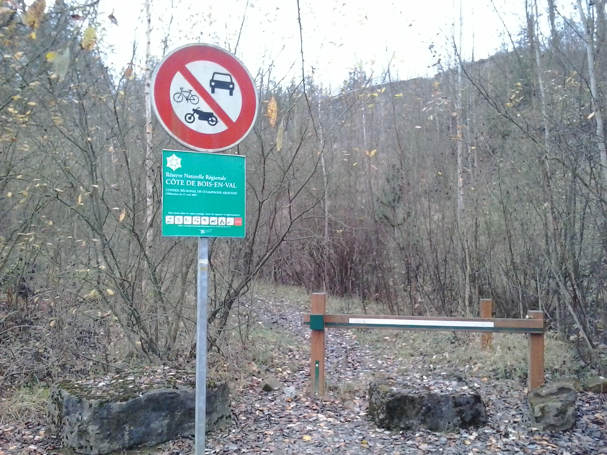
A green nature reserve sign and a circular prohibition sign for vehicles are mounted on a metal pole at the edge of a forest trail, with a wooden barrier gate nearby.
Information and prohibition sign at the entrance of Réserve naturelle régionale de la côte de Bois-en-Val.

Réserve naturelle régionale de la côte de Bois-en-Val history and protected-area timeline

The history of the site is primarily a history of extraction followed by a history of protection. Until the 1950s, the limestone slopes east of Charleville-Mézières were actively worked as a quarry. Stone was cut for construction, and the rock was also burned in a kiln on site to produce quicklime. The remains of this lime kiln are still visible on the ground, marking the former industrial footprint of the hillside. Once quarrying ceased, the site was abandoned and vegetation began to recolonize the worked faces, screes, and former access tracks. Naturalists visiting the recovering woodland recognized that the unusual combination of lime-rich substrates, varied slope exposures, and the presence of waterlogged hollows was producing a remarkable range of habitats in a small area. Documentation of this natural interest goes back many years before formal protection. Recognition of the site's ecological value became formalized in 1991, when it was registered as a ZNIEFF type I inventory area under the name «Bois et anciennes carrières de la Côte de Bois en Val». This designation flagged the area as a priority zone for biodiversity monitoring, although the site still lacked binding protection regime. By 6 March 2001, the area was classified as a réserve naturelle volontaire, the predecessor designation that gave the commune a legal basis to begin work on a long-term management framework. An initial management plan covered the years 2003 to 2005, providing the first structured program for the site. A more durable form of protection was put in place on 21 April 2008, when the council of the Grand Est region (then Champagne-Ardenne) reclassified the area as a réserve naturelle régionale for a renewable ten-year term. The reserve is administered by the commune of Charleville-Mézières under a series of rolling management plans, including a second-generation plan covering 2011 to 2015. The site continues to be managed as a small but ecologically rich urban-adjacent reserve,

Réserve naturelle régionale de la côte de Bois-en-Val landscape and geographic character

The reserve occupies a section of the coteaux de Berthaucourt, a line of wooded hills on the right bank of the Meuse east of Charleville-Mézières. Although the reserve is extremely small, the topography is varied within a short distance because the slopes combine dry, sunny faces with cooler, damper hollows at the foot of the hill. The upper, well-drained parts of the coteau carry thin, rocky soils over calcareous bedrock. These are the locations where calcicole beech woodland, planted pines, and stretches of lime and maple forest have established themselves. Former quarry workings leave exposed cliffs, ledges, and scree surfaces that break up the woodland cover and create niches for warmth-loving plants. Lower down the slope, the topography flattens into wetter ground shaped by seepage and small watercourses. Here, a small pond with a fringe of reedbed is the focal point of the aquatic habitat, surrounded by peat-forming thickets and damp grassland that contrast sharply with the dry upper slopes. The proximity of such different landscapes within a single 24-hectare block is one of the defining landscape features of the reserve. The exposed rock faces and worked quarry surfaces also provide an accessible geology lesson. The visible strata illustrate local sedimentary layering, which the reserve uses as part of its educational activities and nature trails.

Réserve naturelle régionale de la côte de Bois-en-Val ecosystems, habitats, and plant life

Ecologically, the reserve is best understood as a habitat mosaic. Despite its very limited surface area, the site compresses several quite distinct habitat types into one continuous space. Calcicole beech woodland, mixed lime and maple stands, and patches of pine forest dominate the dryer slopes. Marly grassland and scrub occupy transitional zones. Wet ground, a pond and its reedbed, and peat-forming thickets occupy the lowest parts of the coteau. This habitat range is largely the product of the geological substrate and the abandonment of quarrying. The limestone-derived soils favor species adapted to calcareous conditions, while the wet hollows favor mire, marsh, and aquatic species that would not normally occur so close to a dry hillside community. The resulting overlap is unusually high for a site of this size. The reserve is recognized for its botanical importance. Flora surveys have identified roughly 225 plant species, including orchids such as the marsh helleborine (Epipactis palustris) and the early marsh orchid (Dactylorhiza incarnata), along with specialist plants such as the great water-parsnip (Sium latifolium) and a notable set of ferns that includes the crested buckler fern (Dryopteris cristata) and the marsh fern (Thelypteris palustris). These species, particularly the ferns and orchids, are sensitive indicators of habitat quality and underline how intact the reserve's conditions remain. The invertebrate fauna is similarly rich. More than 530 moth species have been recorded, including the protected or notable species of which the black-veined moth-like «Damier noir» is emblematic. Beetle diversity is also substantial, with around 115 documented species. This invertebrate richness supports the rest of the food web and helps explain the reserve's strong amphibian, reptile, and bird populations on a surface of only a few dozen hectares.

Réserve naturelle régionale de la côte de Bois-en-Val wildlife and species highlights

Although the reserve covers only about 24 hectares, its wildlife profile is unusually dense. Bird surveys have recorded approximately 95 species, a remarkable count for such a small site, reflecting the proximity of woodland, open ground, wetland, and rocky outcrops. Species of conservation interest include the red-backed shrike (Lanius collurio) and the European stonechat (Saxicola rubicola), as well as various raptors that use the wooded coteau and the open edges above the Meuse. The mammal fauna is similarly diverse in relative terms, with more than 35 species identified. The combination of woodland, marshy ground, and proximity to the Meuse valley provides cover, forage, and corridors for a wide range of small mammals and larger species typical of the Ardennes foothills. Amphibians are a particular strength of the reserve. The pond and surrounding wet habitats support more than a dozen amphibian and reptile species combined. The northern crested newt (Triturus cristatus) and the midwife toad (Alytes obstetricans) are among the amphibian species recorded, both of which are regarded as indicators of high-quality freshwater and terrestrial habitat. The site's invertebrate communities reinforce its broader ecological importance. With well over 500 moth species and more than 100 beetle species, the reserve provides an unusually rich prey base for bats, birds, and other predators, and it functions as a de facto invertebrate sanctuary that is disproportionately significant for its size.

Réserve naturelle régionale de la côte de Bois-en-Val conservation status and protection priorities

The reserve's conservation value comes primarily from its function as a compact, well-protected refuge for calcareous and wetland species in a heavily populated region. The Grand Est and particularly the Ardennes have lost much of their traditional limestone grassland and wetland habitat to agriculture, forestry, and urbanization, so the recovery of these habitats within the reserve has a significance well beyond its 24-hectare footprint. The site's layered protection history underlines that significance. Long before it gained formal reserve status, it was identified as a ZNIEFF type I inventory area in 1991, which marked it as one of the priority sites for biodiversity monitoring in the department. Its classification as a voluntary nature reserve in 2001 and then as a regional nature reserve in 2008 provided progressively stronger legal tools, including ten-year renewable protection and obligations for management planning. The reserve is also treated as an IUCN Category IV protected area, which corresponds to a habitat/species management area. In practice this means the site is actively managed to maintain the open and semi-open habitats that make it valuable; without intervention, succession would gradually close the marly grasslands and reduce the open-ground species that are central to its interest. From a regional perspective, the reserve acts as a biological stepping stone for the broader Meuse valley network. It links more extensive forest and meadow systems upstream and downstream of Charleville-Mézières, and it serves as a convenient outdoor laboratory for local conservation groups and educational institutions that monitor plant, bird, and invertebrate populations over time.

Réserve naturelle régionale de la côte de Bois-en-Val cultural meaning and human context

The reserve's cultural dimension is closely linked to its industrial past and its urban setting. The presence of the old lime kiln, along with the worked faces and cuttings of the former quarry, gives the site a tangible industrial heritage that connects the contemporary ecological landscape to several generations of local extractive activity. The reuse of the term «côte de Bois-en-Val» in the reserve's name explicitly preserves the identity of this older landscape. Because the reserve sits less than a kilometer from the center of Charleville-Mézières, it plays a strong role in the everyday cultural life of the city. Marked trails make the woodland and the former quarry directly accessible to residents and visitors, and the site is used by local naturalists and schools for introductory biodiversity and geology activities that highlight the natural heritage available at the very edge of an urban area. The reserve can also be read as an example of how French communes have taken on direct responsibility for small protected natural sites. Administration by the commune of Charleville-Mézières, rather than by a national park authority or a regional body, reflects a model in which municipal government has become the steward of a locally meaningful natural area with both ecological and historical significance.

Top sights and standout views in Réserve naturelle régionale de la côte de Bois-en-Val

A 24-hectare urban-adjacent reserve whose dry limestone coteaux, abandoned quarry faces, and small wetland mosaic combine to support around 225 plant species, 95 bird species, more than 35 mammal species, and a particularly strong amphibian, moth, and beetle fauna. The still-visible remains of an old lime kiln link the site's current ecological richness to its history as a working quarry until the 1950s, while accessible trails and exposed rock strata make the reserve a popular introduction to both regional biodiversity and local geology.

Best time to visit Réserve naturelle régionale de la côte de Bois-en-Val

Spring and early summer are the most rewarding periods to visit, when the marly grasslands and woodland edges come into flower and orchids such as the marsh helleborine and the early marsh orchid are visible. Late spring and early summer also coincide with peak bird activity on the coteau, when species such as the red-backed shrike and the European stonechat are easiest to observe around the open areas. Mild, dry days in late spring or early summer also make the rocky upper slopes most accessible, since the paths traverse old quarry faces and outcrops that can be slippery in wet weather. Outside of this main flowering and breeding window, visits in late summer and early autumn still allow observation of the reserve's varied vegetation structure and its wetland features, while winter visits tend to be quieter but offer clearer views across the wooded slopes above the Meuse.

Monthly climate preview

Long-term representative temperature ranges and precipitation patterns across the Ardennes landscape

Réserve naturelle régionale de la côte de Bois-en-Val Climate Normals and Weather by Month

Representative NASA Power climatology tracking long-term average temperature variations and monthly precipitation measurements for Réserve naturelle régionale de la côte de Bois-en-Val. Complete twelve-month meteorological profiles provide deeper analytical context for studying annual weather rhythms across the protected area.
Annual mean9 °C
1 °C18 °C
Jan
Feb
Mar
Apr
May12°
Jun15°
Jul18°
Aug18°
Sep14°
Oct
Nov
Dec
Warmest month
July

17.7 °C

Coolest month
January

0.8 °C

Wettest month
December

3.1 mm/day

Driest month
April

1.8 mm/day

Park location guide

Geography guide, regional context, and park location map for Réserve naturelle régionale de la côte de Bois-en-Val

Réserve naturelle régionale de la côte de Bois-en-Val park geography, regions, and map view in France

Understand where Réserve naturelle régionale de la côte de Bois-en-Val sits in France through a broader geographic reading of the surrounding landscape, nearby location context, and its mapped position within the national park landscape.

How Réserve naturelle régionale de la côte de Bois-en-Val fits into France

France is a unitary semi-presidential republic and one of the world's largest economies. It borders Belgium, Luxembourg, Germany, Switzerland, Italy, Monaco, Andorra, and Spain, with a maritime border to the United Kingdom. The country is known for its cultural influence, art, cuisine, and political history spanning centuries.

Wider geography shaping Réserve naturelle régionale de la côte de Bois-en-Val in France

France is located in Western Europe. Metropolitan France extends from the Rhine to the Atlantic Ocean and from the Mediterranean Sea to the English Channel and North Sea. The country borders Belgium, Luxembourg, Germany, Switzerland, Italy, Monaco, Andorra, Spain, and has a maritime border with the United Kingdom.

Map view of Réserve naturelle régionale de la côte de Bois-en-Val

Use this park location map to pinpoint Réserve naturelle régionale de la côte de Bois-en-Val in France, understand its exact geographic position, and read its mapped placement within the surrounding landscape more clearly.

Pigeon | © OpenStreetMap contributors

Location context for Réserve naturelle régionale de la côte de Bois-en-Val

ArdennesGrand Est

Photographic reference for limestone hillsides, recovering quarries, and diverse protected habitats

Visual Exploration of Réserve naturelle régionale de la côte de Bois-en-Val Landscapes and Scenery

Visual records capture the complex terrain, rocky limestone outcrops, and varied vegetation communities of Réserve naturelle régionale de la côte de Bois-en-Val. Photographic documentation reveals how steep calcareous slopes, abandoned quarry scars, and damp wetland pockets intersect within a compact regional landscape.

A green nature reserve sign and a circular prohibition sign for vehicles are mounted on a metal pole at the edge of a forest trail, with a wooden barrier gate nearby.

The moss-covered stone archway and walls of a historic lime kiln partially hidden in a wooded area.

Park atlas

Compare nearby regional nature reserves, wooded limestone hills, and Meuse valley habitats.

Parks Near Réserve naturelle régionale de la côte de Bois-en-Val and Surrounding Protected Areas

Continue browsing other protected areas and regional nature reserves located near Réserve naturelle régionale de la côte de Bois-en-Val. Comparing adjacent limestone coteaux and woodland habitats reveals broader ecological patterns across the Ardennes department.
A horizontal watercolor illustration depicting rolling green hills, scattered evergreen trees, and distant ridgelines in a soft, light-filled style.
Protected landscapeNamur
About 26 km away#1 closest

North

Parc naturel Viroin-Hermeton: Protected Landscape and Geographic Atlas for Namur, Belgium

Karst geology, limestone tienne hills, and river valley terrain

Parc naturel Viroin-Hermeton covers a vast area in Namur province, defined by its geological contrast and biodiversity. The landscape features deep karst fissures known as fondrys, sunny limestone tienne hills, and dramatic river valleys where the Eau Noire and Eau Blanche meet. This atlas entry provides a structured look at the terrain, mapping the transition from agricultural plateau to forest ecosystems within this significant protected area.

Area
480 km²
Established
1998
IUCN
V
Relief
Mixed relief
Watercolor illustration of a landscape with rolling hills, a river, and green vegetation
Protected areaProvince of Luxembourg
About 30 km away#2 closest

East

Gaume Natural Park: A Protected Area Defining the Landscape of Province of Luxembourg

Explore its mapped natural landscape and geographic context.

Gaume Natural Park is a protected area offering a unique perspective on the natural landscapes found within Belgium's Province of Luxembourg. As a key geographic entity, it provides a vital component for atlas exploration, showcasing distinct mapped boundaries and regional terrain. Understand its significance as a protected natural space contributing to the Ardennes region's extensive geography, making it an essential point for structured discovery of protected lands.

Area
581.04 km²
Established
2014
IUCN
V
Relief
Lowland
Nature reserveHauts-de-France
About 37 km away#3 closest

West

Réserve naturelle régionale des prairies humides de la ferme du Moulin Fontaine Protected Area

Wet meadow conservation in the Hauts-de-France region

Spanning 38 hectares in the Aisne department, this nature reserve focuses on the protection of humid grasslands. The site exemplifies regional efforts to maintain semi-natural habitats through a mosaic of hedgerows, moist meadows, and historic farm architecture in the Thiérache landscape.

Area
0.381 km²
Established
2014
IUCN
IV
Watercolor illustration showing a winding river flowing through a lush green valley with distant hills under a soft pink and yellow sky.
Nature reserveGrand Est
About 39 km away#4 closest

North

Réserve naturelle nationale de la pointe de Givet: Protected Nature Reserve and Geological Atlas

Limestone cliffs, Meuse valley geography, and botanical enclaves in Grand Est

Covering 354 hectares of fragmented terrain, this nature reserve protects a vital corridor of limestone pavements, rocky scree, and dry grasslands. It hosts the internationally recognized Givétian geological stage and provides critical habitat for protected southern plant species. The area offers a distinct geographic profile where medieval fortifications and Vauban military history intersect with specialized forest and cave ecosystems along the Meuse river.

Area
3.54 km²
Established
1999
IUCN
III
Relief
Upland
Nature reserveHauts-de-France
About 50 km away#5 closest

Northwest

Réserve naturelle régionale des monts de Baives: Protected Limestone and Calcareous Landscapes

Ecological geography and regional conservation map context

Encompassing roughly 19 hectares, the Réserve naturelle régionale des monts de Baives protects a specialized ecosystem at the edge of the Ardennes foothills. The site is recognized for its south-facing limestone slopes, orchid-rich grasslands, and historical quarry habitats that support regional bat colonies and unique botanical species.

Area
0.188 km²
Established
1996
IUCN
IV
Relief
Upland
A soft watercolor illustration showing a calm river flowing through a lush, green landscape with forested hills in the distance.
Protected landscapeProvince de Luxembourg
About 58 km away#6 closest

Northeast

Parc naturel des Deux Ourthes: Protected Landscape and Ardennes River Geography

Exploring the forested plateaus and meandering valleys of the Belgian Ardennes

Parc naturel des Deux Ourthes presents a complex geography defined by the convergence of the Ourthe river branches and the expansive Forêt de Freyr. This protected landscape contains rare upland peat bogs and dramatic rock formations, offering a dense, multi-layered terrain that defines the ecological character of the Province de Luxembourg. Its boundaries reflect a significant commitment to forest preservation and habitat conservation within the broader Wallonian natural context.

Area
760 km²
Established
2001
IUCN
V
Relief
Mountain
A soft watercolor illustration of a gentle winding river flowing through a green, rolling landscape with scattered trees and distant, hazy hills.
Regional parkProvince de Luxembourg
About 69 km away#7 closest

East

Parc naturel Haute-Sûre Forêt d'Anlier: Regional Park and Protected Forest Landscapes

Geography and mapped river basins of the Belgian Ardennes

Covering over 800 square kilometers, this regional park protects the significant deciduous woodlands of the Anlier massif and the Sûre river valleys. Analyze the geographic scope of this Natura 2000 protected area, tracing its upland terrain and dense riparian networks across the municipalities of the Belgian Ardennes.

Area
833 km²
Established
2001
Water
Major water bodies
Nature reserveHauts-de-France
About 73 km away#8 closest

Southwest

Réserve naturelle régionale des coteaux du Chemin des Dames Protected Landscape Atlas

Mapped limestone coteaux and grassland mosaic in Aisne

Covering roughly 47 hectares across nine communes, this nature reserve protects the chalky hillslopes characteristic of the Picardy landscape. Its fragmented site structure serves as a key focus for regional biodiversity, maintaining dry calcareous grasslands and scrubland corridors within a wider agricultural matrix.

Area
0.476 km²
Established
2015
IUCN
IV
Scope
Terrestrial

Common questions about visiting, size, designation, and location context for Réserve naturelle régionale de la côte de Bois-en-Val

Réserve naturelle régionale de la côte de Bois-en-Val FAQs for park facts, access, geography, and protected area context

Find quick answers about Réserve naturelle régionale de la côte de Bois-en-Val, including protected-area facts, park geography, trail and visitor context, and how the park fits into its surrounding country and regional landscape.
MoriAtlas Explorer

Continue Your Protected Areas Search Across the Global Atlas

Deepen your exploration by continuing the structured search for national parks and protected areas worldwide. Utilize the comprehensive filtering capabilities to compare different conservation landscapes and refine your understanding of global park geography. Discover more about the distribution and characteristics of protected natural areas.

Global natural geography