
Mori Atlas logo
Nature reserveRéserve naturelle régionale des Jasseries de Colleigne

Examining the high-altitude moorlands, peat bogs, and glacial valley terrain of the Hautes Chaumes

Réserve naturelle régionale des Jasseries de Colleigne in the Monts du Forez Protected Landscape

The Réserve naturelle régionale des Jasseries de Colleigne encompasses 285 hectares within the Hautes Chaumes du Forez of central-eastern France. This regional nature reserve protects a vital mosaic of high-altitude habitats including moorlands, peat bogs, and beech-fir forests that thrive between 1,300 and 1,600 meters in elevation. By managing the interaction between alpine grazing traditions and sensitive ecological niches, the protected area maintains a unique montane environment within the larger Massif Central range.

regional nature reserveupland plateauopen habitatsmoorlandpeat boggrasslands
A stylized vector illustration of a mountainous valley with a large, flat-topped mountain, a waterfall cascading over a cliff, pine trees in the foreground, and a bright sun in the sky.

Réserve naturelle régionale des Jasseries de Colleigne

Nature reserve

Park overview

Structured park overview, official facts, and landscape profile for Réserve naturelle régionale des Jasseries de Colleigne

Réserve naturelle régionale des Jasseries de Colleigne park facts, protected area profile, and essential visitor context

Review the core facts for Réserve naturelle régionale des Jasseries de Colleigne, including designation, size, terrain, visitor scale, habitats, and operating context in one park-focused overview.

About Réserve naturelle régionale des Jasseries de Colleigne

The Réserve naturelle régionale des Jasseries de Colleigne sits high in the Monts du Forez, the crystalline uplands of the northern Massif Central in the Loire department of France. Established as a voluntary nature reserve in 1985 and formally reclassified and enlarged in 2009, the reserve now extends across approximately 285 hectares of the Hautes Chaumes du Forez, a landscape of open plateaus shaped by centuries of summer pastoral use.

At elevations between roughly 1,300 and 1,600 meters, slightly below the Pierre-sur-Haute relay station that marks one of the highest points of the range, the reserve captures a transitional landscape between the modern forestry of the mid-slopes and the more exposed uplands above. The terrain belongs in part to the glacial valley of Chorsin, where rare montane forests of beech and fir survive alongside the open habitats that dominate the reserve.

The site is valued above all for the persistence of open habitats in a French context where such environments are rapidly declining. Rather than being a strict wilderness reserve, the Jasseries de Colleigne is shaped by ongoing extensive grazing, which keeps moorlands, peat bogs, and semi-natural grasslands from being lost to forest encroachment. This blend of active cultural landscape and high-mountain biodiversity gives the reserve a distinctive identity within the network of French regional nature reserves.

Quick facts and research context for Réserve naturelle régionale des Jasseries de Colleigne

The Réserve naturelle régionale des Jasseries de Colleigne lies in the Monts du Forez, on the commune of Sauvain in the Loire department, in the Auvergne-Rhône-Alpes region of France. It occupies a high-altitude zone of the Hautes Chaumes du Forez, between roughly 1,300 and 1,600 meters in elevation, and covers approximately 285 hectares.

Originally created as a voluntary nature reserve in November 1985 on about 55 hectares, it was reclassified as a regional nature reserve in October 2009 and significantly extended. It is classified as a Regional Nature Reserve (UICN Category IV) and managed by the Conservatoire d'espaces naturels de Rhône-Alpes.

Protection and recognition

Documented terrestrial protection scope, designation year, and official recognition records

Réserve naturelle régionale des Jasseries de Colleigne Protection Status and Designation History

Terrestrial protection status for Réserve naturelle régionale des Jasseries de Colleigne traces official designation records established in 2009. Official database registries compile documented management scope and conservation listings for this protected area.

Protection details

Protection scope
Terrestrial
Designated year
2009
Transboundary protection
No
WDPA ID
555514336
Park context

Deeper park guide and search-rich context for Réserve naturelle régionale des Jasseries de Colleigne

Réserve naturelle régionale des Jasseries de Colleigne history, landscape, wildlife, and travel context

Explore Réserve naturelle régionale des Jasseries de Colleigne through its history, landscape character, ecosystems, wildlife, conservation priorities, cultural context, and seasonal travel timing in a structured park guide built for atlas discovery and search intent.

Why Réserve naturelle régionale des Jasseries de Colleigne stands out

The reserve is best known for preserving a high-altitude mosaic of open habitats, including moorlands, peat bogs, and grasslands within the Hautes Chaumes du Forez. It safeguards a landscape type, open upland pastures and associated peatland, that has become increasingly scarce in France, while also protecting protected plant species such as the inundated clubmoss, bog rosemary, sundew, martagon lily, and cranberry, alongside threatened butterflies like the marsh fritillary and the cranberry fritillary.
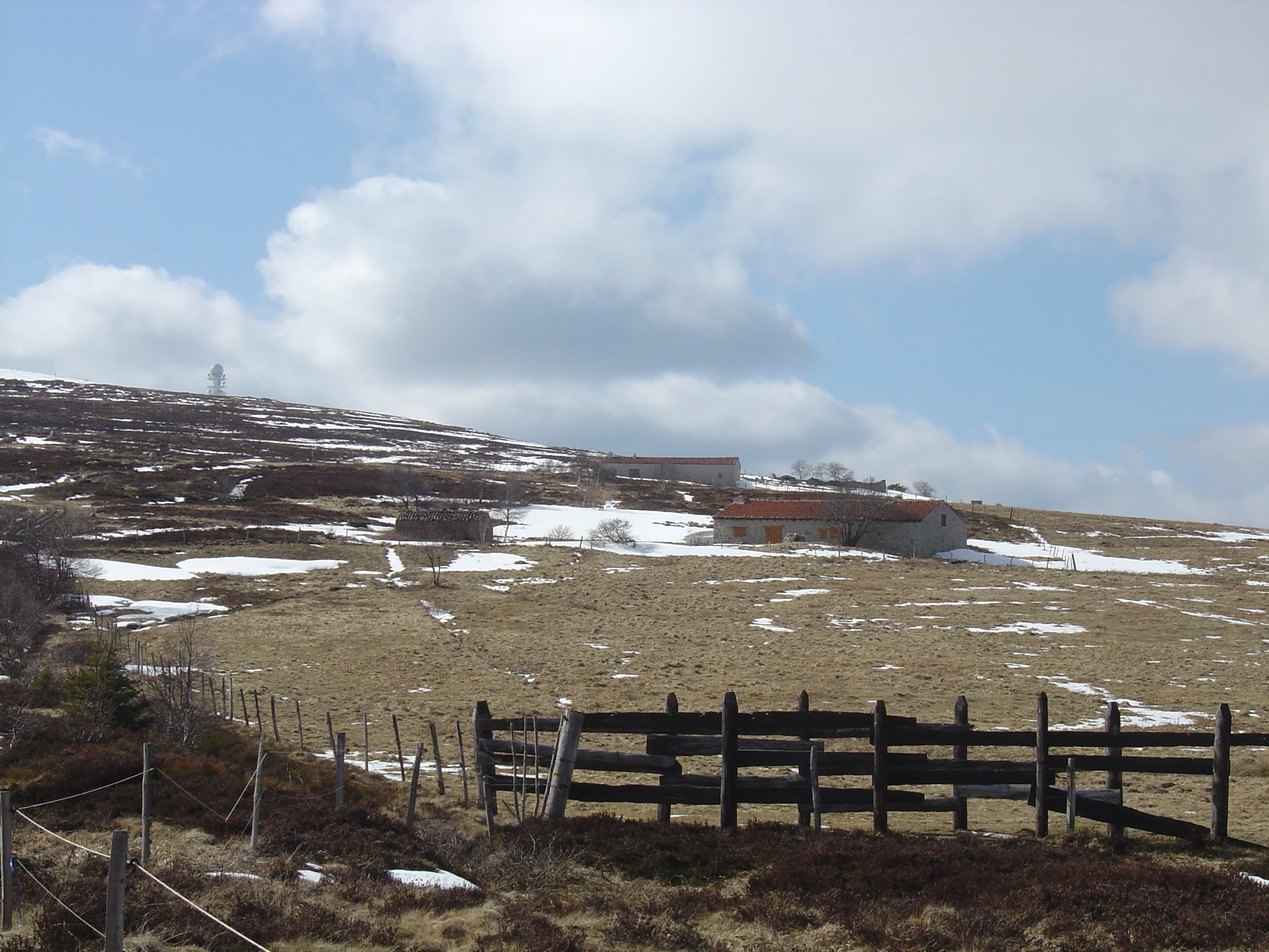
A wide view of a sloping, grassy mountain field under a cloudy sky, with patches of snow on the ground and several traditional low-slung stone buildings with reddish roofs in the mid-distance.
Historic Jasseries at the Jasseries de Colleigne nature reserve, characterized by their distinct low architecture in the Hautes Chaumes du Forez.

Réserve naturelle régionale des Jasseries de Colleigne history and protected-area timeline

The origins of the reserve lie in a regional effort to protect a representative sample of the Hautes Chaumes du Forez, an open upland landscape that had been steadily shrinking across the Massif Central. On 25 November 1985, a decree published in the Journal Officiel created a voluntary nature reserve (réserve naturelle volontaire) covering about 55.67 hectares on the commune of Sauvain.

Over the following decades, the voluntary status proved too limited to secure long-term protection for the broader landscape. On 27 October 2009, the regional council of Rhône-Alpes classified the site as a regional nature reserve, significantly expanding its footprint to the current 285 hectares and adopting a new management framework. The reserve was officially inaugurated by the regional authorities and local elected representatives on 4 July 2011.

Since its reclassification, the Jasseries de Colleigne has been managed by the Conservatoire d'espaces naturels de Rhône-Alpes. A consultative committee oversees the management plan, which centers on maintaining the open habitats, protecting peatlands, and ensuring that continued traditional pastoral use remains compatible with conservation goals.

Réserve naturelle régionale des Jasseries de Colleigne landscape and geographic character

The reserve lies on the upper slopes of the Monts du Forez, a mid-mountain range of the northern Massif Central, between roughly 1,300 and 1,600 meters in altitude. Its setting is dominated by the Hautes Chaumes du Forez, raised plateaus of open moorland and grassland that contrast sharply with the denser forests found lower down the range.

Within the reserve, the topography is shaped partly by glacial history, notably through the Chorsin valley, a glacially carved corridor where the rare patches of beech and fir forest survive. Around and above this valley, the land opens into a rolling mosaic of moorlands, peat bogs, tall-herb meadows, and grazed grasslands. Traditional stone jasseries, the seasonal mountain farm buildings that give the reserve its name, dot the landscape and reinforce the sense of a cultural highland terrain shaped by transhumant grazing.

The combination of exposed summits, peat-filled hollows, glacial valley remnants, and scattered montane woodland gives the Jasseries de Colleigne a varied and legible mountain landscape, one in which the imprint of pastoral traditions remains clearly visible in the open character of much of the terrain.
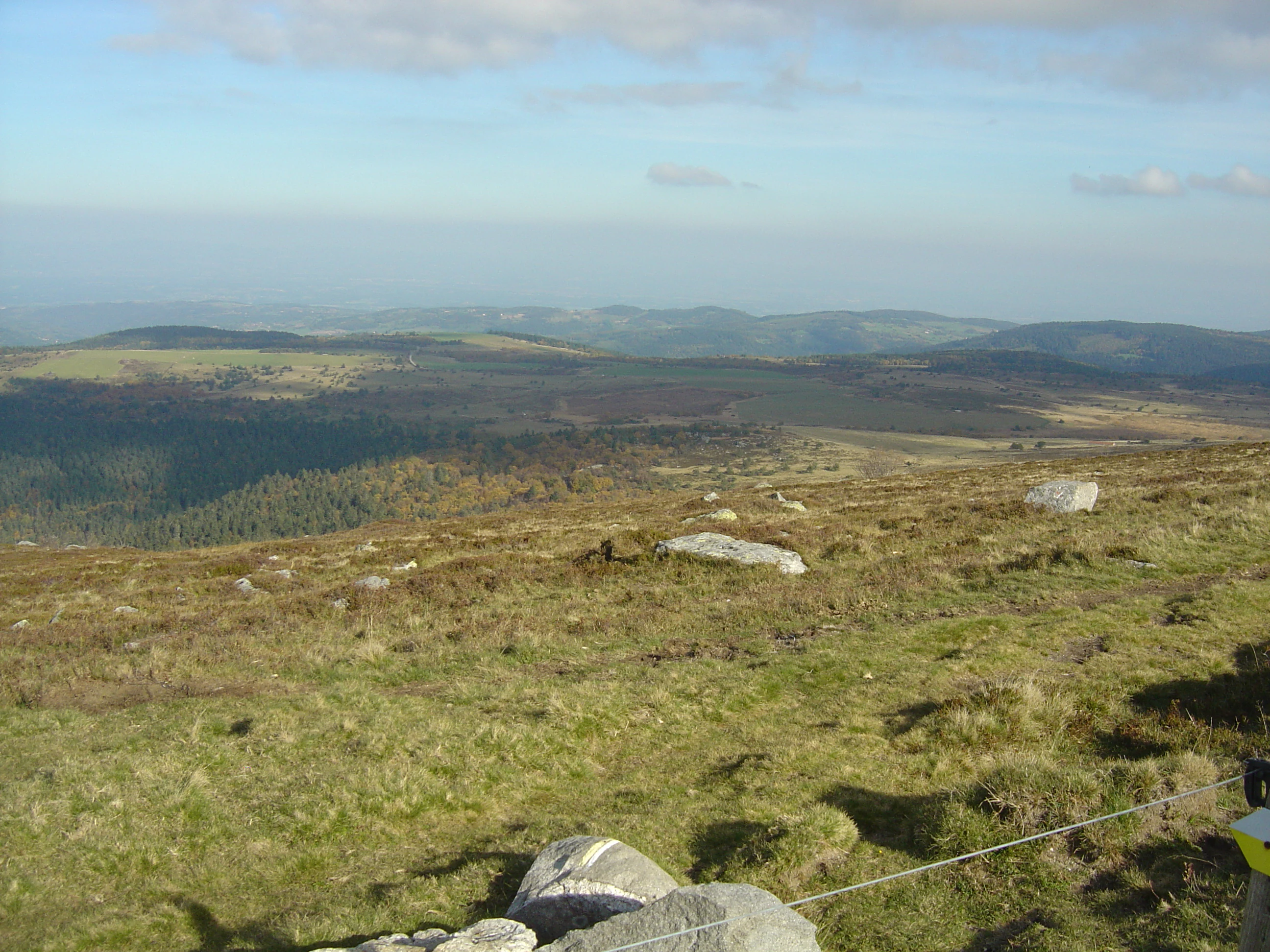
A wide, high-angle view of grassy, rolling highlands with scattered rocks and distant hills under a partly cloudy sky.
Panoramic overview of the open highlands within the Jasseries de Colleigne nature reserve.

Réserve naturelle régionale des Jasseries de Colleigne ecosystems, habitats, and plant life

The ecological interest of the reserve is rooted in the diversity of habitats packed into a relatively small upland area. The site harbors a mosaic of open environments, including moorland, dry and mesophilic grasslands, peat bogs, tall-herb formations, and natural beech-fir forest, with the balance between them actively maintained by extensive grazing.

Moorlands are particularly important, as they depend on continued low-intensity pastoral use to prevent natural forest regeneration. Peat bogs, among the most fragile habitats present, are a focal point of conservation management. The natural beech-fir forests of the Chorsin valley, by contrast, are left unexploited, providing a reference for what the original forest cover of the area once looked like and a refuge for species associated with old-growth woodland.

This habitat diversity supports a rich upland flora, including sixteen protected plant species. Notable examples include the inundated clubmoss, bog rosemary, sundew, martagon lily, and cranberry, plants characteristic of nutrient-poor, acidic, and moisture-rich mountain substrates that have become rare across much of lowland France.

Réserve naturelle régionale des Jasseries de Colleigne wildlife and species highlights

The fauna of the Jasseries de Colleigne reflects the open, montane character of the reserve. Open-country bird species are particularly well represented, with species such as the woodlark and common quail recorded within the reserve, alongside harriers and a wider community of raptors typical of the Monts du Forez, including the red kite, sparrowhawk, short-toed snake eagle, and several falcon species that hunt across the upland mosaics.

Insects of conservation interest are another notable feature of the reserve. Two threatened butterflies, the marsh fritillary and the cranberry fritillary, depend on the combination of moorland, peat bog, and cranberry-rich habitats that the reserve protects, making the site regionally significant for invertebrate conservation.

Together, the bird, raptor, and invertebrate interest of the reserve illustrates how a small area of well-managed high-altitude open habitat can continue to support a characteristic community of mid-mountain species that face pressure elsewhere in France.

Réserve naturelle régionale des Jasseries de Colleigne conservation status and protection priorities

The reserve's conservation significance lies primarily in its role as a refuge for open upland habitats and their associated species. Open environments, including moorlands, semi-natural grasslands, and peat bogs, have declined sharply across France, and the Jasseries de Colleigne protects a coherent block of these habitats in the Monts du Forez.

Management, led by the Conservatoire d'espaces naturels de Rhône-Alpes, focuses on maintaining the delicate balance between grazing, peatland integrity, and forest dynamics. Extensive pastoral agriculture is actively encouraged as a tool to keep moorlands and grasslands open, while the rare beech-fir forests of the Chorsin valley are explicitly excluded from timber exploitation in order to preserve their ecological value.

The reserve also serves as a reference site for studying the interaction between traditional highland land use and biodiversity. By combining habitat protection with the continuation of low-intensity pastoral farming, it illustrates a conservation approach that recognizes open landscapes as products of long-standing human activity as much as of natural processes.

Réserve naturelle régionale des Jasseries de Colleigne cultural meaning and human context

The cultural identity of the reserve is closely tied to the traditional highland pastoralism of the Forez mountains. The word jasserie comes from the low Latin jacium, meaning a place to lie or rest, and originally referred to the summer pastures where transhumant livestock grazed during the warm season. Over time, the term shifted by metonymy to refer to the stone farm buildings erected on those pastures, which remain a characteristic feature of the landscape.

These jasseries, along with the continued practice of summer grazing, reflect a centuries-old relationship between local communities and the uplands of the Forez. The reserve's management today conserves not only the ecological value of the open habitats but also this cultural practice, sustaining the agricultural and architectural heritage of the Hautes Chaumes alongside the natural heritage.

Top sights and standout views in Réserve naturelle régionale des Jasseries de Colleigne

The reserve's strongest points of distinction include its high-altitude position within the Hautes Chaumes du Forez, its conservation of a rare open-habitat mosaic, and its combination of moorland, peat bog, and glacial-valley beech-fir forest within a single protected unit. It is further distinguished by the presence of sixteen protected plant species and two threatened butterfly species that depend on its specialized habitats.

Equally notable is the way the reserve integrates active pastoral farming into its conservation strategy, treating extensive grazing as essential to the persistence of the open landscapes it protects. This blend of ecological and cultural landscape preservation gives the Jasseries de Colleigne a distinctive profile among French regional nature reserves.

Best time to visit Réserve naturelle régionale des Jasseries de Colleigne

The reserve is most rewarding when its open highland landscapes are most accessible and visually expressive, typically from late spring through early autumn, when the snow has receded from the Hautes Chaumes and the moorlands and grasslands are in active growth. Summer brings the full pastoral atmosphere of the jasseries, with livestock on the upper pastures and traditional farm buildings in regular use.

Late spring highlights the wetland and bog flora of the reserve, while midsummer offers the broadest display of upland flowering species and active birdlife. Outside the snow-free months, access becomes more difficult and the landscape is dominated by winter conditions, with limited visibility of the open habitats that define the reserve.
Monthly climate preview

Long term temperature and precipitation patterns across the representative protected elevation point

Réserve naturelle régionale des Jasseries de Colleigne Climate and Monthly Weather Normals

Representative coordinate records show average monthly temperatures ranging from sub-zero winter lows to warm summer maximums alongside measured daily precipitation values. Examining the complete twelve month climate profile reveals full seasonal variations and long term meteorological trends across the protected terrain.
Annual mean9 °C
1 °C19 °C
Jan
Feb
Mar
Apr
May12°
Jun16°
Jul19°
Aug19°
Sep14°
Oct10°
Nov
Dec
Warmest month
July

19.2 °C

Coolest month
January

0.8 °C

Wettest month
May

2.5 mm/day

Driest month
March

1.2 mm/day

Park location guide

Geography guide, regional context, and park location map for Réserve naturelle régionale des Jasseries de Colleigne

Réserve naturelle régionale des Jasseries de Colleigne park geography, regions, and map view in France

Understand where Réserve naturelle régionale des Jasseries de Colleigne sits in France through a broader geographic reading of the surrounding landscape, nearby location context, and its mapped position within the national park landscape.

How Réserve naturelle régionale des Jasseries de Colleigne fits into France

France is a unitary semi-presidential republic and one of the world's largest economies. It borders Belgium, Luxembourg, Germany, Switzerland, Italy, Monaco, Andorra, and Spain, with a maritime border to the United Kingdom. The country is known for its cultural influence, art, cuisine, and political history spanning centuries.

Wider geography shaping Réserve naturelle régionale des Jasseries de Colleigne in France

France is located in Western Europe. Metropolitan France extends from the Rhine to the Atlantic Ocean and from the Mediterranean Sea to the English Channel and North Sea. The country borders Belgium, Luxembourg, Germany, Switzerland, Italy, Monaco, Andorra, Spain, and has a maritime border with the United Kingdom.

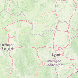
Map view of Réserve naturelle régionale des Jasseries de Colleigne

Use this park location map to pinpoint Réserve naturelle régionale des Jasseries de Colleigne in France, understand its exact geographic position, and read its mapped placement within the surrounding landscape more clearly.

Pigeon | © OpenStreetMap contributors

Location context for Réserve naturelle régionale des Jasseries de Colleigne

Auvergne-Rhône-Alpes
Recorded earthquake history

Review Recorded Earthquake Activity Near Réserve naturelle régionale des Jasseries de Colleigne

Explore a catalog of historical seismic events identified by their proximity to the Réserve naturelle régionale des Jasseries de Colleigne. MoriAtlas provides this data as a resource for understanding the historical context of recorded ground movement across the Monts du Forez.

Jasseries de Colleigne Earthquake History

Catalogued events

12 events

Strongest magnitude

Magnitude 3.5

Most recent event

Nov 5, 2001

This history includes earthquakes recorded inside the park or within 50 km of its borders

Explore high-altitude terrain, moorland plateaus, and glacial valleys through detailed protected-area photography.

Visualizing Réserve naturelle régionale des Jasseries de Colleigne: Landscapes, Scenery, and Protected Habitats

Visual records reveal the diverse highland terrain, open moorlands, and peat bogs that characterize the protected plateaus of the reserve. Examining these landscape views and habitat photographs helps visitors understand the unique environmental character of the protected area.

A wide view of a sloping, grassy mountain field under a cloudy sky, with patches of snow on the ground and several traditional low-slung stone buildings with reddish roofs in the mid-distance.

A long, single story stone building with a red tiled roof, situated in a high altitude field with patches of melting snow.

A wide, high-angle view of grassy, rolling highlands with scattered rocks and distant hills under a partly cloudy sky.

Park atlas

Compare adjacent highland reserves and neighboring mountain geography across the region.

Explore Protected Areas Near Réserve naturelle régionale des Jasseries de Colleigne

Browse other protected natural areas sharing similar high-altitude moorlands, glacial valleys, and pastoral plateaus. Expanding the search helps contextualize regional conservation landscapes and surrounding mountain terrain.
A horizontal watercolor painting showing a soft, stylized river winding through green hills and forests.
Regional parkAuvergne-Rhône-Alpes
37 km away#1 closest

Southeast

Réserve naturelle régionale des gorges de la Loire: Landscape and Protected Area Geography

Regional nature reserve in the Auvergne-Rhône-Alpes landscape.

The Réserve naturelle régionale des gorges de la Loire protects a rugged stretch of the Loire River valley in the eastern Massif Central. Discover the geographic mosaic of rocky outcrops, shrubby heaths, and woodland slopes that define this protected area, and see how the terrain shapes its distinct biodiversity and river corridor boundaries.

Area
3.55 km²
Established
1988
IUCN
IV
Relief
Upland
Nature reserveAuvergne-Rhône-Alpes
43 km away#2 closest

South

Réserve naturelle régionale du lac de Malaguet: Regional Nature Reserve and Wetland Atlas

Mapped protected landscapes in Haute-Loire, Auvergne-Rhône-Alpes

This protected area centers on a 14th-century artificial lake that now functions as a rich ecological sanctuary. Explore the confluence of medieval water infrastructure, riparian forests, and meadow zones that support diverse upland fauna. The site offers a clear example of long-term landscape transformation from industrial utility to a protected biodiversity refuge within the eastern Massif Central.

Area
0.542 km²
Established
2014
IUCN
IV
Relief
Upland
Nature reserveAuvergne-Rhône-Alpes
About 50 km away#3 closest

West

Réserve naturelle régionale du Puy de Marmant: Volcanic Geography and Protected Terrain

Regional nature reserve in the Auvergne-Rhône-Alpes landscape.

This protected site preserves a prominent volcanic hill and its surrounding dry grasslands within the Limagne basin. The reserve serves as an ecologically significant island, maintaining specialized thermophilous plants and rare geological formations composed of basalt and peperite. It remains an essential reference for understanding the volcanic heritage and unique botanical diversity of the Puy-de-Dôme department.

Area
0.203 km²
Established
1985
IUCN
IV
Relief
Upland
A soft watercolor painting of a wide, rolling landscape with green hills, pale mountain silhouettes in the background, and a faint reddish-brown foreground, presented on a white background.
Natural monumentAuvergne-Rhône-Alpes
53 km away#4 closest

West

Chaîne des Puys - faille de Limagne: Mapping Volcanic and Tectonic Protected Landscapes

Geological exploration of the Auvergne-Rhône-Alpes volcanic chain

Spanning a rhythmic skyline of roughly eighty volcanoes, the Chaîne des Puys - faille de Limagne represents a premier site for studying continental rifting and volcanic landforms. This protected monument offers a clear view into the interplay between the ancient mountain basement, the massive Limagne fault, and the resulting volcanic edifices that define the regional identity of the Auvergne-Rhône-Alpes area.

Area
242.23 km²
Established
2018
Relief
Mountain
Climate
Temperate
Nature reserveAuvergne-Rhône-Alpes
About 64 km away#5 closest

East

Réserve naturelle régionale de la mine du Verdy: A Subterranean Protected Area in France

Mapping the ecological geography of the Monts du Lyonnais.

The Réserve naturelle régionale de la mine du Verdy stands as France's smallest nature reserve, protecting an intricate network of abandoned mining galleries beneath the surface of the Monts du Lyonnais. This site serves as a crucial underground sanctuary for diverse bat species and cave-dwelling invertebrates, showcasing how repurposed industrial landscapes can harbor significant biodiversity within the Auvergne-Rhône-Alpes region.

Area
0.001 km²
Established
1990
IUCN
IV
Relief
Upland
Nature reservePuy-de-Dôme
65 km away#6 closest

West

Réserve naturelle régionale des cheires et grottes de Volvic: Volcanic Landscapes and Bat Habitats

A regional nature reserve within the Puy-de-Dôme volcanic terrain

This protected area captures the geological signature of the Puy de la Nugère, where trachy-andésite lava flows form a stark surface landscape known as cheires. Beneath these flows, an extensive network of abandoned quarries provides stable cavities for diverse bat species, creating a dual-layered ecological site within the Chaîne des Puys.

Area
0.613 km²
Established
2014
IUCN
IV
Visitors
100K annual
A soft watercolor painting depicting rolling green hills and distant faint mountains under a light sky.
Nature reservePuy-de-Dôme
About 67 km away#7 closest

West

Réserve naturelle nationale du rocher de la Jaquette Protected Area and Volcanic Landscape

Explore rocky cliffs and rare entomological habitats in the Puy-de-Dôme region.

Situated on the flanks of a volcanic outcrop above the Rentières valley, this nature reserve protects a diverse habitat mosaic within the Massif Central. The site provides essential breeding grounds for protected raptors and represents one of the most significant insect sites in central France, offering a clear view into regional volcanic ecology and mountain-valley geography.

Area
0.362 km²
Established
1976
IUCN
IV
Relief
Mountain
A watercolor illustration of a serene landscape with rolling hills, a meandering river, and soft light.
Regional parkAuvergne-Rhône-Alpes
73 km away#8 closest

South

Parc naturel régional des Monts d'Ardèche: Protected Landscapes and Geographic Map Context

Volcanic highland terrain within the Auvergne-Rhône-Alpes region

Covering over 248,000 hectares, Parc naturel régional des Monts d'Ardèche represents a significant protected area in the southern Massif Central. The region is marked by its distinctive volcanic sucs, including Mont Gerbier-de-Jonc, and a complex network of Cévenol river valleys. It remains a focal point for understanding the transition between high volcanic plateaus and traditional terraced agricultural slopes in southeastern France.

Area
2,280 km²
Established
2001
IUCN
V

Common questions about visiting, size, designation, and location context for Réserve naturelle régionale des Jasseries de Colleigne

Réserve naturelle régionale des Jasseries de Colleigne FAQs for park facts, access, geography, and protected area context

Find quick answers about Réserve naturelle régionale des Jasseries de Colleigne, including protected-area facts, park geography, trail and visitor context, and how the park fits into its surrounding country and regional landscape.
MoriAtlas Explorer

Continue Your Protected Areas Search Across the Global Atlas

Deepen your exploration by continuing the structured search for national parks and protected areas worldwide. Utilize the comprehensive filtering capabilities to compare different conservation landscapes and refine your understanding of global park geography. Discover more about the distribution and characteristics of protected natural areas.

Global natural geography