Mori Atlas logo
Nature reserveRéserve naturelle régionale du coteau et prairies des Caforts

Mapping the limestone hillsides, wet meadows, and subterranean galleries of this regional nature reserve

Réserve naturelle régionale du coteau et prairies des Caforts: Protected Geography and Landscape

(Réserve naturelle régionale du coteau et prairies des Caforts (RNR215))

The Réserve naturelle régionale du coteau et prairies des Caforts in the Pays de la Loire region of France preserves a compact but geologically diverse landscape. This protected area integrates a calcareous hillside with rare orchids, an adjacent wet meadow fed by the Organne stream, and a network of historic tuffeau limestone galleries. These distinct terrain elements provide habitat for numerous bat species and unique plant communities within a single, highly focused geographic boundary.

regional nature reservecalcareous grasslandwet meadowcave systemlimestone hillsideorchids

Réserve naturelle régionale du coteau et prairies des Caforts

Nature reserve

Park overview

Structured park overview, official facts, and landscape profile for Réserve naturelle régionale du coteau et prairies des Caforts

Réserve naturelle régionale du coteau et prairies des Caforts park facts, protected area profile, and essential visitor context

Review the core facts for Réserve naturelle régionale du coteau et prairies des Caforts, including designation, size, terrain, visitor scale, habitats, and operating context in one park-focused overview.

About Réserve naturelle régionale du coteau et prairies des Caforts

The Réserve naturelle régionale du coteau et prairies des Caforts occupies a small but layered corner of the Loir valley in the southern Sarthe. Its three contrasted habitats, dry limestone hillside, wet meadow, and underground galleries, are squeezed together by a department road and the small Organne stream, creating a mosaic that is unusually compact for a French regional nature reserve. This tight patchwork of exposures (sunny slope, humid ground, and cool caves) gives the site its character and much of its biodiversity value.

The reserve was recognized formally as a Réserve naturelle régionale by the Pays de la Loire regional council on 14 December 2009, building on more than fifteen years of prior stewardship. The Conservatoire d'espaces naturels de la Sarthe, which had managed the land since 1993, first acquired the hillside and its cave in 1995 and later added the wet meadow across the road in 2005. A 2023 extension expanded the perimeter to roughly 6.35 hectares. The area has also been integrated into broader ecological frameworks, including two ZNIEFF inventories and the Natura 2000 zone of the Loir valley between Vaas and Bazouges.

Ecologically, the site functions as a refuge for species that depend on the specific combination of calcareous grassland, humid meadow, and subterranean cavities that the region would otherwise struggle to maintain. Botanists have recorded more than 270 vascular plant species, including several orchids and other calcareous-cliff specialists, while faunal surveys have documented roughly 250 species, including an exceptional bat community. At the same time, the reserve preserves a tangible element of regional cultural heritage, since its underground galleries were once part of the medieval tuffeau quarrying industry and later hosted mushroom farms until the 1970s.

Quick facts and research context for Réserve naturelle régionale du coteau et prairies des Caforts

The Réserve naturelle régionale du coteau et prairies des Caforts is located in the Sarthe department, in the Pays de la Loire region of western France, near the town of Luché-Pringé and within the broader valley of the Loir river. It is classified as a regional nature reserve (Réserve naturelle régionale), corresponding to IUCN Category IV, a designation for areas managed primarily to conserve particular species or habitats.

Established on 14 December 2009 and later expanded in 2023, the reserve today covers around 6.35 hectares. It protects a limestone hillside, an underground gallery system originating from quarries, and a wet meadow associated with the small Organne stream that flows into the Loir. The site sits within two ZNIEFF inventories and within the Natura 2000 zone of the Vallée du Loir.

Protection and recognition

Review documented protection history and management records for Réserve naturelle régionale du coteau et prairies des Caforts

Protection Status and International Recognition for Réserve naturelle régionale du coteau et prairies des Caforts

Examine the verified protection status and administrative designation records established for Réserve naturelle régionale du coteau et prairies des Caforts. Access structured conservation data detailing international source registries and management frameworks associated with the protected landscape.

Protection details

WDPA ID
555559601
Park context

Deeper park guide and search-rich context for Réserve naturelle régionale du coteau et prairies des Caforts

Réserve naturelle régionale du coteau et prairies des Caforts history, landscape, wildlife, and travel context

Explore Réserve naturelle régionale du coteau et prairies des Caforts through its history, landscape character, ecosystems, wildlife, conservation priorities, cultural context, and seasonal travel timing in a structured park guide built for atlas discovery and search intent.

Why Réserve naturelle régionale du coteau et prairies des Caforts stands out

The reserve is best known for the unusual combination of a calcareous slope, a flooded meadow, and former quarry caves all contained within a very small protected area. The limestone geology, with Turonian tuffeau stone, has produced both a hillside habitat rich in orchids and a network of subterranean galleries, where bats and historically mushroom cultivation found refuge. It is also recognized for its surprisingly rich biodiversity inventories: more than 270 plant species and around 250 faunal species have been documented within its boundaries. Among these, orchids such as the monkey orchid and the early spider orchid, butterflies like the large copper, and a community of sixteen bat species give the reserve a strong naturalist reputation.
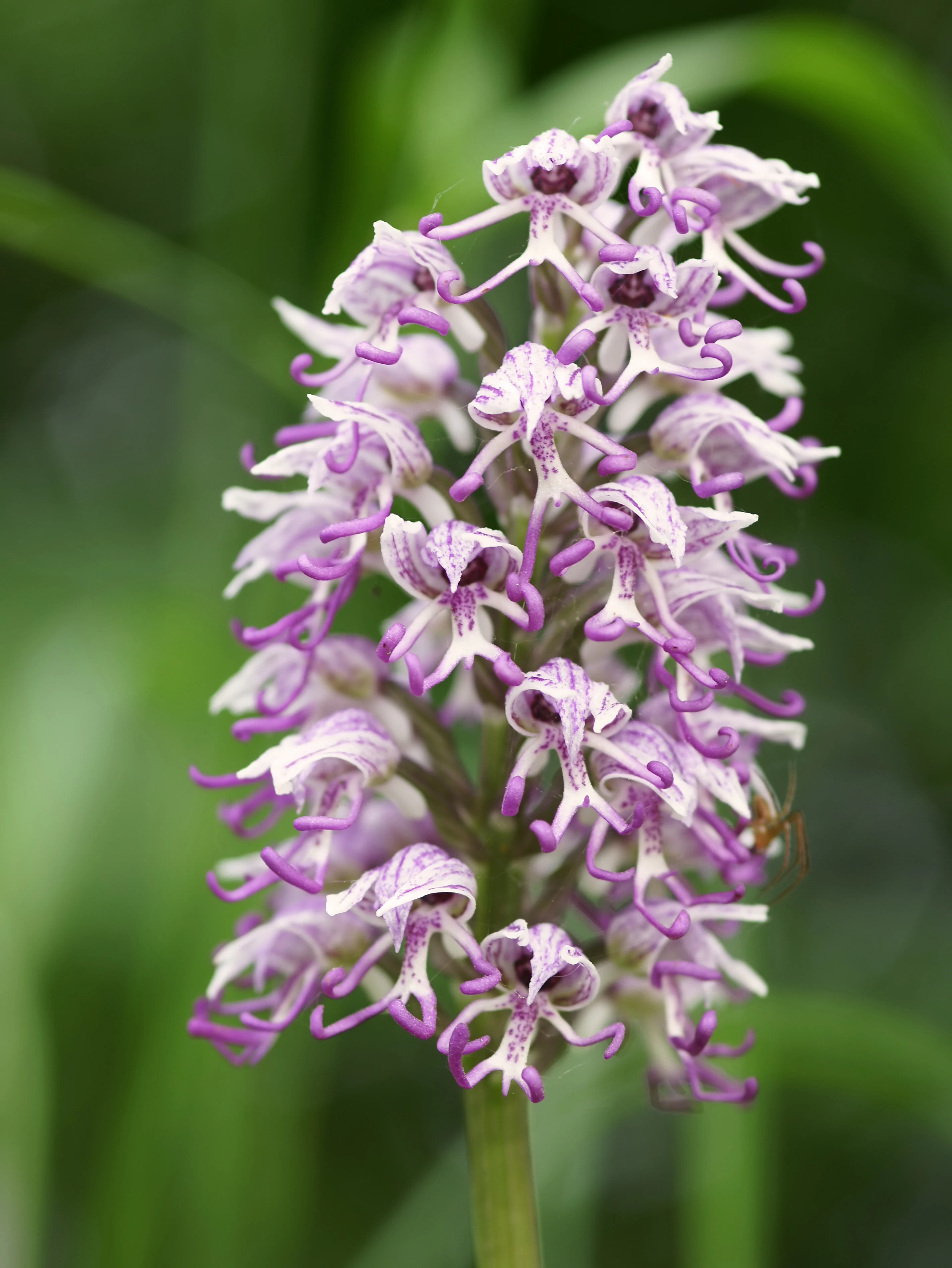
A close-up photograph of a Monkey orchid (Orchis simia) flower stalk featuring many small, light purple and white, patterned flowers against a soft-focus green background.
A close-up view of a Monkey orchid inflorescence.

Réserve naturelle régionale du coteau et prairies des Caforts history and protected-area timeline

The natural and human history of the Caforts site are tightly intertwined. The valley of the Loir contains Turonian tuffeau limestone, a soft, workable stone that drew quarrying activity to the area from the Middle Ages onward. At Luché-Pringé, the Caforts site preserves about 910 meters of subterranean galleries and a troglodyte house associated with that quarrying heritage, and the caves were used as champignonnières, underground mushroom farms, until the 1970s.

Modern conservation history began in 1993, when the Conservatoire d'espaces naturels de la Sarthe took over management of the site. The conservatoire acquired the hillside and its cave in 1995 and later expanded its holdings by purchasing the wet meadow located on the opposite side of the departmental road in 2005. After years of stewardship and ecological restoration, the Conseil régional des Pays de la Loire officially classified the site as a Réserve naturelle régionale on 14 December 2009. A subsequent deliberation of 7 July 2023 extended the reserve's perimeter to about 6.35 hectares, formalizing the wider mosaic now under protection.

Réserve naturelle régionale du coteau et prairies des Caforts landscape and geographic character

The landscape of the Caforts reserve is shaped by the geology and hydrology of the middle Loir valley. The hillsides along the Loir in this part of Sarthe expose tuffeau limestone of Turonian age, a pale, fine-grained stone historically prized for building. At Caforts, this limestone forms a calcareous slope that rises above the valley floor, providing the dry, sunny conditions that favor specialized grassland flora.

Below the slope and across the departmental road, the terrain shifts to a wet meadow fed by the small Organne stream before it joins the Loir near the reserve. This contrast between an upper dry hillside and a lower humid plain, separated by a road and a watercourse, gives the protected site its characteristic two-tier structure. Beneath both, the inherited quarry network pierces the hillside with roughly 910 meters of galleries and at least one troglodyte dwelling, creating a third, subterranean landscape element that visitors and bats share.

The wider setting is classic gentle-river-valley countryside: rolling agricultural land, the Loir river corridor, and small historic villages such as Luché-Pringé. Within that broader patchwork, the reserve stands out as a compact parcel where natural slope vegetation, traditional wet meadow, and historical underground cavities have been deliberately kept together.

Réserve naturelle régionale du coteau et prairies des Caforts ecosystems, habitats, and plant life

Ecologically, the reserve is a textbook example of a habitat mosaic on calcareous bedrock. The open hillside supports calcareous grassland communities with orchids and other species adapted to thin, sun-exposed soils. The hillside woodland fringe and edge habitats add structural diversity, while the wet meadow across the road hosts moisture-loving plants along the Organne stream.

The cave and gallery system introduces a third ecological dimension, a stable, dark, underground environment quite different from the open habitats above. Together, the three habitats allow species with very different requirements to coexist within a few hundred meters of one another. The combination of dry calcareous slope, humid meadow, and cave is uncommon at this scale in the region, which is why ecologists have documented high species counts for such a small area.

More than 270 plant species and roughly 250 faunal species have been recorded. Notable botanical records include Cyperus longus, Thalictrum flavum, Orchis simia, Ophrys sphegodes, Ononis natrix, and Buglossoides purpurocaerulea. These species reflect the rich intersection of calcareous-grassland and wet-meadow flora that defines the site's ecological identity.

Réserve naturelle régionale du coteau et prairies des Caforts wildlife and species highlights

The wildlife of the Caforts reserve is shaped by the meeting of three different habitat worlds. The open calcareous slope is favorable to reptiles that bask on warm stones, including the western green lizard (Lacerta bilineata), the common wall lizard (Podarcis muralis), and the asp viper (Vipera aspis). The humid meadow, by contrast, draws invertebrates and amphibians associated with damp grassland and the nearby stream.

The site is particularly important for bats: sixteen species have been recorded, a remarkable total for such a small area. Twelve of these species use the underground galleries as roosting or hibernation habitat, while four are typically found above ground on the hillside. Notable species include the greater horseshoe bat (Rhinolophus ferrumequinum), Bechstein's bat (Myotis bechsteinii), and the common noctule (Nyctalus noctula).

Butterflies are another highlight. The reserve supports species of conservation interest such as the large copper (Lycaena dispar), the marbled fritillary (Brenthis ino), the large blue (Phengaris arion), and the Adonis blue (Lysandra bellargus), whose presence is tied to the combination of humid meadow flowers and calcareous grassland plants found across the protected land.

Réserve naturelle régionale du coteau et prairies des Caforts conservation status and protection priorities

From a conservation standpoint, the reserve is significant less for its size than for its concentration of habitat types within a small area. The site demonstrates how a calcareous hillside, a meadow along a small stream, and a cave system can be managed together to sustain a surprising number of rare species, an approach that supports both habitat-based and species-based conservation goals.

Management is handled by the Conservatoire d'espaces naturels de la Sarthe, which has overseen the site since 1993 and progressively assembled the parcels that now make up the reserve. The reserve is included in two ZNIEFF inventories, the Coteau du Loir et carrière souterraine de la Violonnerie and the Vallée du Loir de Pont-de-Braye à Bazouges, and lies within the Natura 2000 zone covering the Vallée du Loir from Vaas to Bazouges. These broader designations reinforce its role as a key node within the regional ecological network of the Loir valley.

Réserve naturelle régionale du coteau et prairies des Caforts cultural meaning and human context

The Caforts site carries a clear cultural dimension tied to the human use of the Loir valley. The underground galleries are a direct legacy of medieval tuffeau quarrying, and the presence of a troglodyte house reflects a long tradition of cave-dwelling architecture along the Loir. Until the 1970s, parts of the galleries were used as mushroom farms, an important element of the local rural economy in this part of France.

The traditional rural setting of the commune of Luché-Pringé and the broader valley's heritage of stone-built villages, river landscapes, and small-scale agriculture provide the wider cultural background against which the reserve is preserved.

Top sights and standout views in Réserve naturelle régionale du coteau et prairies des Caforts

Key elements that define the reserve's identity include the 910 meters of preserved tuffeau galleries with their troglodyte house, the calcareous slope with rare orchids, and the wet meadow linked to the Organne stream.

Equally striking is the bat fauna: sixteen recorded species, including twelve that use the underground cavities, place this small site on the regional map for chiropteran conservation. The blend of limestone geology, cultural heritage, and high species counts in a protection-friendly footprint is the reserve's defining combination.

Best time to visit Réserve naturelle régionale du coteau et prairies des Caforts

The reserve can be visited freely year-round, but seasonal conditions strongly shape what visitors can see. Spring and early summer are especially rewarding on the calcareous hillside, when orchids such as Orchis simia and Ophrys sphegodes come into bloom and the slope's wildflowers are at their peak.

Summer brings butterflies, including species such as the large copper and the Adonis blue, to the meadow and the edge habitats. Autumn and winter, while quieter above ground, are important for bat observation at the cave entrances, when many species congregate for hibernation. The gentle climate of the Loir valley means that vegetation and wildlife follow a fairly typical temperate Western European seasonal cycle.
Monthly climate preview

Long-term monthly temperature averages and precipitation patterns for this protected area

Réserve naturelle régionale du coteau et prairies des Caforts Climate and Temperature Rhythms

Representative coordinate measurements show mean monthly temperatures ranging from 4.28 °C to nearly 20 °C alongside recorded precipitation normals across the twelve-month cycle. Examining the full monthly climate dataset reveals detailed baseline variations in long-term temperature ranges and precipitation rates.
Annual mean12 °C
4 °C20 °C
Jan
Feb
Mar
Apr10°
May14°
Jun18°
Jul20°
Aug20°
Sep17°
Oct12°
Nov
Dec
Warmest month
August

20 °C

Coolest month
January

4.3 °C

Wettest month
December

2.5 mm/day

Driest month
August

1.5 mm/day

Park location guide

Geography guide, regional context, and park location map for Réserve naturelle régionale du coteau et prairies des Caforts

Réserve naturelle régionale du coteau et prairies des Caforts park geography, regions, and map view in France

Understand where Réserve naturelle régionale du coteau et prairies des Caforts sits in France through a broader geographic reading of the surrounding landscape, nearby location context, and its mapped position within the national park landscape.

How Réserve naturelle régionale du coteau et prairies des Caforts fits into France

France is a unitary semi-presidential republic and one of the world's largest economies. It borders Belgium, Luxembourg, Germany, Switzerland, Italy, Monaco, Andorra, and Spain, with a maritime border to the United Kingdom. The country is known for its cultural influence, art, cuisine, and political history spanning centuries.

Wider geography shaping Réserve naturelle régionale du coteau et prairies des Caforts in France

France is located in Western Europe. Metropolitan France extends from the Rhine to the Atlantic Ocean and from the Mediterranean Sea to the English Channel and North Sea. The country borders Belgium, Luxembourg, Germany, Switzerland, Italy, Monaco, Andorra, Spain, and has a maritime border with the United Kingdom.

Map view of Réserve naturelle régionale du coteau et prairies des Caforts

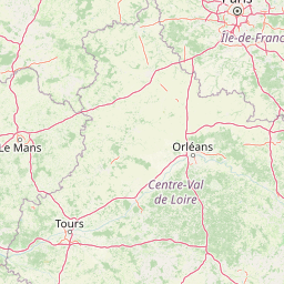
Use this park location map to pinpoint Réserve naturelle régionale du coteau et prairies des Caforts in France, understand its exact geographic position, and read its mapped placement within the surrounding landscape more clearly.

Pigeon | © OpenStreetMap contributors

Location context for Réserve naturelle régionale du coteau et prairies des Caforts

Pays de la Loire

Visualizing calcareous slopes, wet meadows, and subterranean quarry networks

Réserve naturelle régionale du coteau et prairies des Caforts Photos and Landscapes

Photographs capture the diverse terrain of Réserve naturelle régionale du coteau et prairies des Caforts, revealing the striking transition from dry limestone hillsides to humid river valley meadows. Visual documentation provides essential context on rare grassland habitats, subsurface cave networks, and protected natural scenery.

A close-up photograph of a Monkey orchid (Orchis simia) flower stalk featuring many small, light purple and white, patterned flowers against a soft-focus green background.

Park atlas

Compare adjacent limestone valleys, river corridors, and protected natural reserves in Sarthe

Parks Near Réserve naturelle régionale du coteau et prairies des Caforts and Regional Protected Areas

Browsing nearby protected areas allows travelers to compare the unique limestone slopes of Réserve naturelle régionale du coteau et prairies des Caforts with broader regional river valley ecosystems. Evaluating adjacent reserves reveals connected conservation patterns across the surrounding French countryside.
Nature reservePays de la Loire
About 15 km away#1 closest

East

Réserve naturelle régionale des prairies et roselière des Dureaux: Loir Valley Protected Landscapes

Regional Nature Reserve in Pays de la Loire, France

Spanning the alluvial plains near Vaas, this reserve protects essential wet meadows and reedbed communities shaped by the seasonal rhythm of the Loir River. The landscape features a classic bocage character, offering a distinct example of wetland conservation within the Pays de la Loire region.

Area
0.253 km²
Established
2001
IUCN
IV
Relief
Lowland
Nature reservePays de la Loire
About 19 km away#2 closest

West

Réserve naturelle régionale des marais de Cré-sur-Loir et La Flèche Protected Landscape

Wetland ecosystems in the Pays de la Loire region.

Spanning an old meander of the Loir river, this regional nature reserve preserves a complex network of marshes, canals, and alluvial forests. Learn about its unique floodplain geography and the protected wetland habitats that sustain regional biodiversity in the heart of the Sarthe department.

Area
0.531 km²
Established
2008
IUCN
IV
Relief
Lowland
A watercolor painting showing a soft, stylized landscape with rolling green hills, small clusters of trees, and a winding waterway, with tall grass and flowers in the foreground.
Nature reservePays de la Loire
About 31 km away#3 closest

Northeast

Réserve naturelle régionale du bas-marais tourbeux de la Basse-Goulandière: Regional Wetland Mapping

A rare alkaline lowland peatland within the Pays de la Loire administrative region

Examine the mapped terrain and habitat structure of this protected peatland near Le Mans. This site preserves an uncommon alkaline mire environment, serving as an essential ecological bridge within the Roule-Crottes stream valley and demonstrating the significant conservation value of small, high-quality wetland pockets in agricultural landscapes.

Area
0.38 km²
Established
2011
IUCN
IV
A soft watercolor illustration featuring a calm pond in the foreground, with reeds on the right and a distant treeline and rolling hills in the background.
Nature reservePays de la Loire
About 48 km away#4 closest

Southwest

Réserve naturelle régionale des étang et boisements de Joreau: Protected Area Atlas Profile

Wetland and woodland mosaic in the Pays de la Loire region.

This profile examines the 92-hectare Réserve naturelle régionale des étang et boisements de Joreau, a protected area in the Maine-et-Loire department. The site features a specialized composition of freshwater ponds and mature woodlands, reflecting the traditional riverine landscapes found throughout the broader Loire Valley regional geography.

Area
0.92 km²
Established
2015
IUCN
IV
Nature reserveCentre-Val de Loire
About 64 km away#5 closest

South

Marais de Taligny Regional Nature Reserve: A Protected Wetland in Centre-Val de Loire

Alluvial valley geography and restored marshland habitats

Spanning the Négron valley, this regional nature reserve serves as an vital sanctuary for alkaline fen formations and diverse aquatic species. The site provides a detailed look at the intersection of riverine drainage, alluvial woodland, and the successful ecological restoration of historical French wetland landscapes.

Area
0.354 km²
Established
2014
IUCN
IV
Relief
Lowland
Nature reservePays de la Loire
About 64 km away#6 closest

Southwest

Réserve naturelle régionale de Basses-Brosses et Chevalleries: Protected Area Mapping

A dense bocage landscape in the Pays de la Loire region

This regional nature reserve protects a well-preserved mosaic of meadows, cultivated plots, and wooded hedgerows across 90 hectares. The site serves as a vital ecological anchor in the Maine-et-Loire department, maintaining traditional land patterns and diverse species habitats that define the historic rural character of the Anjou countryside.

Area
0.9 km²
Established
2012
IUCN
IV
Nature reservePays de la Loire
About 67 km away#7 closest

South

Réserve naturelle régionale Champagne de Méron: Geographic and Protected Area Overview

A regional nature reserve within the Maine-et-Loire department.

Located in the heart of the Anjou countryside, Réserve naturelle régionale Champagne de Méron represents a strategic effort to safeguard biodiversity within western France. Covering 146 hectares, this protected area illustrates the intersection of modern conservation goals and historic rural landscapes, offering a clear view of how regional authorities manage and restore fragmented natural habitats.

Area
1.461 km²
Established
2023
IUCN
IV
Scope
Terrestrial
A watercolor painting showing a soft, pastoral landscape with green rolling hills, light yellow grasslands, and a tranquil pond in the foreground against a light, hazy sky.
Nature reservePays de la Loire
About 76 km away#8 closest

North

Réserve naturelle régionale du coteau et plateau de Tessé: Protected Limestone Geography

Calcareous grassland landscapes in the Sarthe department

Examine the geography of this regional nature reserve in Pays de la Loire. The site preserves a compact parcel of limestone plateau and slopes, offering a concentrated look at dry calcareous habitat conservation and the distinct geology of the Rutin valley area.

Area
0.056 km²
Established
2009
IUCN
IV
Relief
Upland

Common questions about visiting, size, designation, and location context for Réserve naturelle régionale du coteau et prairies des Caforts

Réserve naturelle régionale du coteau et prairies des Caforts FAQs for park facts, access, geography, and protected area context

Find quick answers about Réserve naturelle régionale du coteau et prairies des Caforts, including protected-area facts, park geography, trail and visitor context, and how the park fits into its surrounding country and regional landscape.
MoriAtlas Explorer

Continue Your Protected Areas Search Across the Global Atlas

Deepen your exploration by continuing the structured search for national parks and protected areas worldwide. Utilize the comprehensive filtering capabilities to compare different conservation landscapes and refine your understanding of global park geography. Discover more about the distribution and characteristics of protected natural areas.

Global natural geography