
Mori Atlas logo
Nature reserveRéserve naturelle régionale du Crêt des Roches

Discover the geographic layout and protected natural terrain within the Doubs valley landscape

Réserve naturelle régionale du Crêt des Roches: A Jurassic Limestone Corniche Protected Area

The Réserve naturelle régionale du Crêt des Roches represents a distinctive protected landscape within the Bourgogne-Franche-Comté region of eastern France. This site protects a significant Jurassic limestone corniche and surrounding dry grasslands, offering a structured look at the unique xerothermic habitats and vertical geological formations carved by the Doubs valley. Researchers and nature enthusiasts can utilize this atlas entry to trace the boundaries of this botanical sanctuary and vital raptor migration observation point.

limestone cornicheregional nature reserveDoubs valleyLomont rangeJurassic limestonexerothermic habitats
A stylized vector illustration of a river flowing through a deep valley between vertical limestone cliffs, surrounded by coniferous and deciduous trees.

Réserve naturelle régionale du Crêt des Roches

Nature reserve

Park overview

Structured park overview, official facts, and landscape profile for Réserve naturelle régionale du Crêt des Roches

Réserve naturelle régionale du Crêt des Roches park facts, protected area profile, and essential visitor context

Review the core facts for Réserve naturelle régionale du Crêt des Roches, including designation, size, terrain, visitor scale, habitats, and operating context in one park-focused overview.

About Réserve naturelle régionale du Crêt des Roches

The Réserve naturelle régionale du Crêt des Roches occupies a compact but unusually diverse section of the Lomont, a limestone ridge that marks the edge of the Jura mountains overlooking the Doubs valley. Its roughly 43 hectares combine the vertical drama of a Jurassic limestone cliff with the more gentle rhythms of summit dry grasslands, rocky slopes, scree, and a forested back-slope, all within a short horizontal distance of Pont-de-Roide-Vermondans.

What gives the site its identity is the sharp transition it embodies between the harsh microclimate of the west- and southwest-facing cliff and the more sheltered forest environments behind the crest. This contrast produces a micro-mosaic of xerophilic, thermophilic, and mesophilic habitats unusually compressed into a small area. Botanists have recognized this richness since the nineteenth century, and the reserve's designated status reflects both the fragility and the biogeographical significance of those habitats.

From a conservation standpoint, the Crêt des Roches is more than a scenic high point above the Doubs. It anchors a network of xerothermic plant communities in the northern Jura fringe, provides refuge for several relict species at the limits of their range, and serves as a key vantage point for monitoring raptor migration through the Doubs valley corridor. The reserve is fully embedded in the Natura 2000 site "Le Crêt des Roches," underlining its role in broader European habitat protection.

In addition, the site is a recognized climbing venue, with several hundred equipped routes on its limestone face, and is equipped for public discovery through a marked trail, information panels, and a panoramic orientation table, reflecting an intentional balance between conservation, recreation, and environmental education.

Quick facts and research context for Réserve naturelle régionale du Crêt des Roches

The Réserve naturelle régionale du Crêt des Roches is a regional nature reserve (RNR) of about 43 hectares, classified on 19 November 2009 and managed by the Conservatoire des Espaces Naturels de Franche-Comté. It lies in the Doubs department, within the Bourgogne-Franche-Comté region, just southeast of Pont-de-Roide-Vermondans.

Its territory corresponds to a Jurassic limestone corniche of the Lomont range, rising around one hundred meters above the Doubs valley, with a maximum elevation of 787 meters at the Tour Carrée. The site encompasses rock-faces, summit grasslands, forested slopes, and scree, providing a compact mosaic of xerophilic to mesophilic habitats. It is also entirely overlapped by the Natura 2000 site "Le Crêt des Roches" (FR4301288), of which it covers roughly 70 percent.

Protection and recognition

Examine terrestrial protection metrics, official registry parameters, and documented administrative history.

Réserve naturelle régionale du Crêt des Roches Protection Status and Designation Data

Terrestrial boundary records and formal protection status outline the regulatory framework governing Réserve naturelle régionale du Crêt des Roches within the global protected area registry. Documented administrative parameters establish the baseline metrics for tracking conservation scope and official geographic designation details.

Protection details

Protection scope
Terrestrial
Transboundary protection
No
WDPA ID
555514366
Park context

Deeper park guide and search-rich context for Réserve naturelle régionale du Crêt des Roches

Réserve naturelle régionale du Crêt des Roches history, landscape, wildlife, and travel context

Explore Réserve naturelle régionale du Crêt des Roches through its history, landscape character, ecosystems, wildlife, conservation priorities, cultural context, and seasonal travel timing in a structured park guide built for atlas discovery and search intent.

Why Réserve naturelle régionale du Crêt des Roches stands out

The Crêt des Roches reserve is best known for two complementary assets. First, its dry-grassland flora on a south- to west-facing limestone corniche, which harbors relict and pioneer Mediterranean-margin species, including the only known Franche-Comté population of Iberis saxatilis. Second, its role as a major observation point for autumn bird migration, particularly for the Red Kite and other raptors, with autumn counts historically reaching tens of thousands of birds passing the corniche.
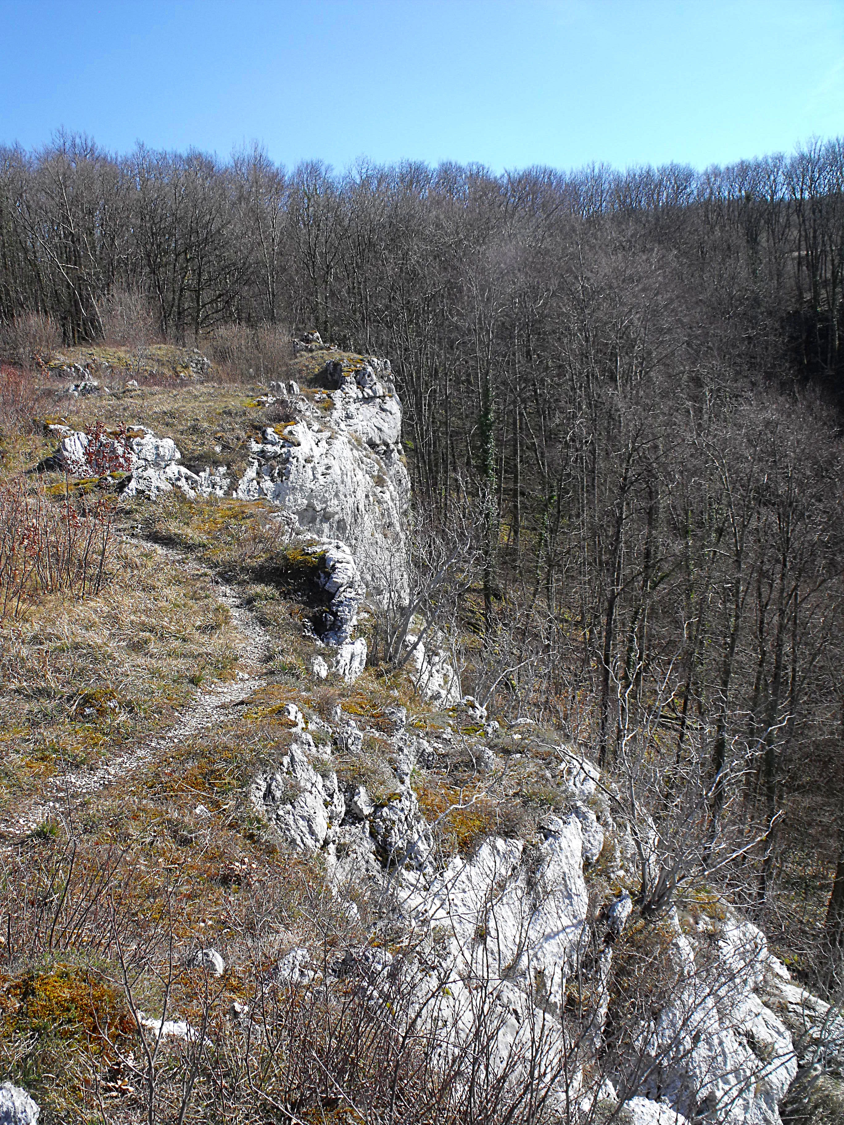
A view of rugged limestone cliffs dropping off into a forest canopy, with a narrow dirt path running along the edge.
Limestone cliffs overlooking the forest at Crêt des Roches Regional Nature Reserve.

Réserve naturelle régionale du Crêt des Roches history and protected-area timeline

The natural heritage of the Crêt des Roches has been documented for well over 150 years. The Besançon naturalist Justin Girod-Chantrans brought the site to broader scientific attention in the nineteenth century, and the first formal floristic inventory of the corniche was carried out in 1854 by Charles Louis Contejean.

Although the scientific value of the site was recognized early, formal protection efforts only began to take shape in the 1970s. The area was first classified as a voluntary nature reserve in 2000, a transitional French designation that was subsequently converted, on 19 November 2009, into the current regional nature reserve status. Since then, the site has been managed by the Conservatoire des Espaces Naturels de Franche-Comté, which oversees habitat restoration, open-area management, and visitor flow at the site.

Réserve naturelle régionale du Crêt des Roches landscape and geographic character

The defining feature of the reserve is a Jurassic limestone corniche, a steep cliff and ridge complex formed when the limestone strata were tilted upward along the Lomont anticline and then eroded by the Doubs river cutting into the valley below. Today the cliff rises roughly one hundred meters above the valley, reaching its highest point at 787 meters near the Tour Carrée.

Because the cliff is oriented successively toward the west in the northern part of the site and toward the southwest further south, where it follows the line of a side valley, it creates very different exposures within a small area. The base of the corniche is mantled in scree, while the summit carries open dry grasslands; behind the crest, slopes descend into more mesophilic forest. The result is a layered landscape with strong vertical organization, abrupt transitions, and panoramic views back toward Pont-de-Roide and across the Doubs valley.
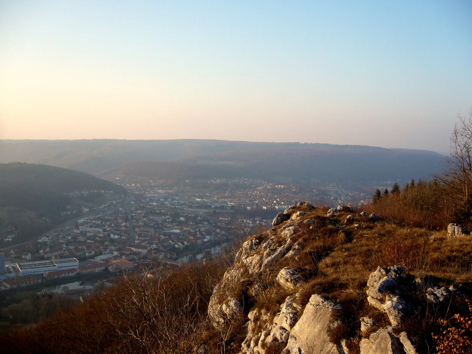
A high vantage point looking down over a town nestled in a valley, with rugged limestone rock formations in the foreground under a hazy sky.
A view overlooking the valley from the limestone cliffs of the Crêt des Roches nature reserve.

Réserve naturelle régionale du Crêt des Roches ecosystems, habitats, and plant life

The ecological identity of the Crêt des Roches lies in the tight juxtaposition of xerophilic and mesophilic habitats across a single landform. Open summit grasslands, thermophilic downy oak woodland, and thermophilic beech woodland dominate the exposed side, while more humid beech and mixed forest occupy the sheltered back-slope. The cliff, the scree, and the upper meadows each support distinct microhabitats.

This topographic and microclimatic variability drives the site's botanical value. The dry grasslands and rocky ledges harbor community types more typical of Mediterranean-margin climates, including several pioneer species at the northern limit of their natural range. At the same time, the protected status and ongoing habitat management by the Conservatoire des Espaces Naturels de Franche-Comté help maintain open habitats against natural forest encroachment, sustaining the mosaics that make the reserve ecologically distinctive.
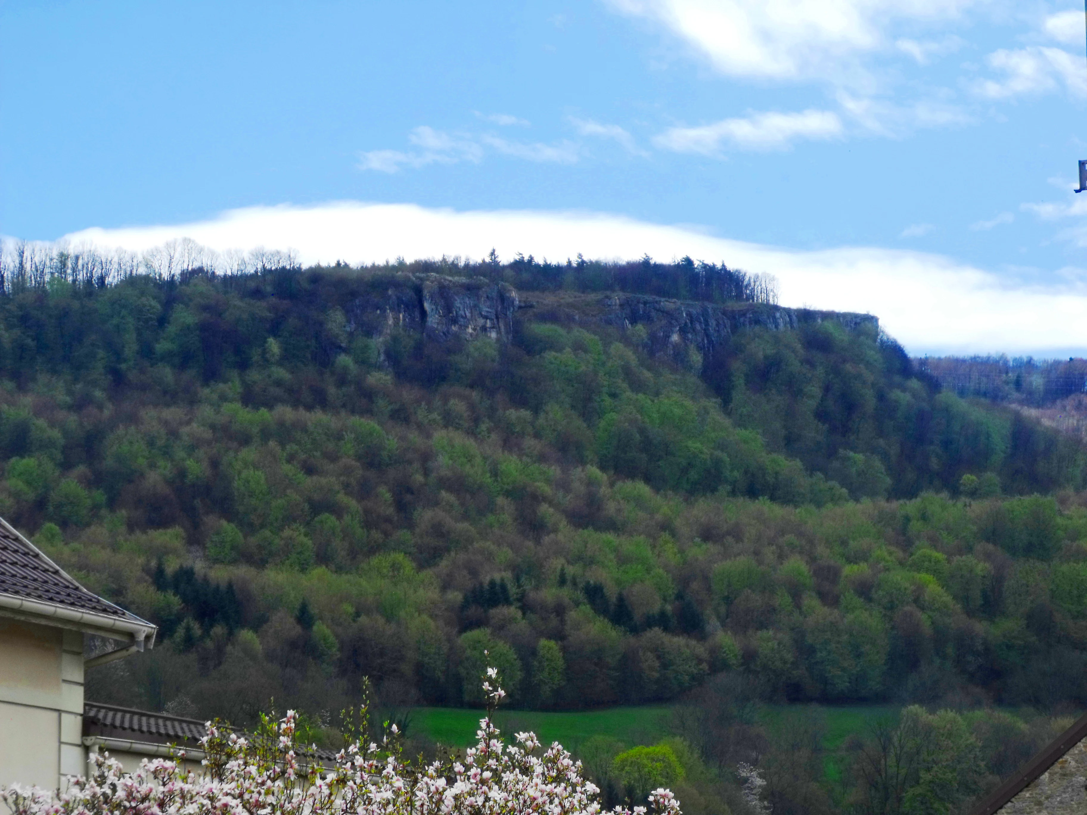
A distant view of a forested limestone cliff ridge known as Crêt des Roches, seen above rolling green hills under a blue sky with light clouds.
The Crêt des Roches limestone ridge viewed from the nearby commune of Pont-de-Roide.

Réserve naturelle régionale du Crêt des Roches wildlife and species highlights

The reserve's most visible wildlife significance lies in its role as a migration observation site, rather than in a resident species inventory. The exposed corniche forms a natural leading line above the Doubs valley, concentrating the autumn post-breeding passage of many raptor and passerine species. Notable historical counts include around 127,000 birds and approximately 1,300 raptors recorded in a single autumn season, with the Red Kite as a particular highlight of the site's ornithological profile.

The dry, thermophilic grasslands also support a characteristic assemblage of warm-loving invertebrates, including the Praying Mantis, the Italian Cricket, and the Stag Beetle. These insects, along with the smaller reptiles and other invertebrates typical of xerothermic habitats, contribute to the broader food web of the corniche and reinforce the reserve's profile as a refuge for Mediterranean-margin fauna in the Jura foothills.

Réserve naturelle régionale du Crêt des Roches conservation status and protection priorities

From a conservation perspective, the Crêt des Roches is significant as a compact refuge for xerothermic plant communities that would otherwise be marginal in this part of the Jura. Several of the species recorded on the corniche, including Iberis saxatilis, reach the limit of their range here, and the only known Franche-Comté population of this rock-cress species occurs on the site.

In addition, the reserve is fully inscribed within the Natura 2000 site "Le Crêt des Roches" (FR4301288), of which it covers roughly 70 percent, extending its conservation role into the European network. Active management by the Conservatoire des Espaces Naturels de Franche-Comté focuses on restoring and maintaining open habitats, controlling woodland expansion, and managing the pressure of visitors and climbers, ensuring that the balance between recreation and habitat protection remains viable for the relict species and communities that the site was created to protect.

Réserve naturelle régionale du Crêt des Roches cultural meaning and human context

The Crêt des Roches holds a meaningful place in the regional scientific heritage of Franche-Comté. Its documentation by Justin Girod-Chantrans in the nineteenth century and the first systematic floristic inventory by Charles Louis Contejean in 1854 link the reserve to a long tradition of botanical study in the Besançon area.

Today, the site also carries a strong recreational and sporting dimension: a portion of the cliff has been developed into a climbing venue with more than 200 equipped routes, integrating the reserve into local outdoor culture. Information panels, an orientation table, and a marked trail connect visitors to both the natural and the historical identity of the corniche.

Top sights and standout views in Réserve naturelle régionale du Crêt des Roches

The combination of a compact 43-hectare footprint with a striking vertical landscape and an unusually diverse flora makes the Crêt des Roches stand out among regional nature reserves in eastern France. Its limestone corniche provides panoramic views over the Doubs valley while sheltering xerothermic plant communities that are otherwise scarce at this latitude.

Equally distinctive is the site's dual identity as both a botanical sanctuary and a migration observatory. Within a single visit, the reserve offers Mediterranean-margin dry grassland species, cliff and scree habitats, a historic climbing site, and a vantage point from which to witness large autumn movements of raptors and other migratory birds.

Best time to visit Réserve naturelle régionale du Crêt des Roches

The Crêt des Roches can be visited at any time of year, but the character of a visit shifts noticeably with the seasons. Late spring and early summer are particularly rewarding for the dry grasslands and cliff flora, when the thermophilic plant communities that define the reserve are most visible and the views across the Doubs valley are at their clearest.

Autumn is the season that gives the reserve its second major identity. The exposed corniche acts as a natural observation point for raptor and passerine migration, a tradition that has made the site well known among regional birdwatchers. Winter and early spring visits offer a quieter, more austere atmosphere and reveal the underlying geology of the cliff and scree, but are generally less suited to observing the full breadth of the site's biodiversity.

Monthly climate preview

Long-term representative point measurements tracking monthly averages and precipitation patterns

Climate Normals and Annual Temperature Rhythm for Réserve naturelle régionale du Crêt des Roches

Representative coordinates record measured monthly temperature swings from subfreezing winter lows to warm summer maximums alongside steady precipitation rates. Detailed monthly climate normals clarify long-term temperature ranges and precipitation trends across the protected area.
Annual mean9 °C
0 °C18 °C
Jan
Feb
Mar
Apr
May13°
Jun16°
Jul18°
Aug18°
Sep14°
Oct
Nov
Dec
Warmest month
July

18.3 °C

Coolest month
January

-0.1 °C

Wettest month
May

3.3 mm/day

Driest month
March

2.2 mm/day

Park location guide

Geography guide, regional context, and park location map for Réserve naturelle régionale du Crêt des Roches

Réserve naturelle régionale du Crêt des Roches park geography, regions, and map view in France

Understand where Réserve naturelle régionale du Crêt des Roches sits in France through a broader geographic reading of the surrounding landscape, nearby location context, and its mapped position within the national park landscape.

How Réserve naturelle régionale du Crêt des Roches fits into France

France is a unitary semi-presidential republic and one of the world's largest economies. It borders Belgium, Luxembourg, Germany, Switzerland, Italy, Monaco, Andorra, and Spain, with a maritime border to the United Kingdom. The country is known for its cultural influence, art, cuisine, and political history spanning centuries.

Wider geography shaping Réserve naturelle régionale du Crêt des Roches in France

France is located in Western Europe. Metropolitan France extends from the Rhine to the Atlantic Ocean and from the Mediterranean Sea to the English Channel and North Sea. The country borders Belgium, Luxembourg, Germany, Switzerland, Italy, Monaco, Andorra, Spain, and has a maritime border with the United Kingdom.

Map view of Réserve naturelle régionale du Crêt des Roches

Use this park location map to pinpoint Réserve naturelle régionale du Crêt des Roches in France, understand its exact geographic position, and read its mapped placement within the surrounding landscape more clearly.

Pigeon | © OpenStreetMap contributors

Location context for Réserve naturelle régionale du Crêt des Roches

Bourgogne-Franche-Comté

Visual exploration of Jurassic limestone corniche terrain, dry grasslands, and protected valley habitats

Réserve naturelle régionale du Crêt des Roches Photos and Limestone Cliff Scenery

Photographs capture the dramatic vertical terrain, exposed limestone cliffs, and specialized dry-grassland habitats defining Réserve naturelle régionale du Crêt des Roches. Visual documentation reveals the distinct ecological character and panoramic valley viewpoints shaping this protected regional landscape.

A view of rugged limestone cliffs dropping off into a forest canopy, with a narrow dirt path running along the edge.

A view through a sparse forest of slender, leafless deciduous trees with a leaf-littered ground, suggesting late autumn or winter.

A high vantage point looking down over a town nestled in a valley, with rugged limestone rock formations in the foreground under a hazy sky.

A distant view of a forested limestone cliff ridge known as Crêt des Roches, seen above rolling green hills under a blue sky with light clouds.

Park atlas

Compare surrounding regional reserves and connected limestone landscapes in eastern France

Explore Protected Areas Near Réserve naturelle régionale du Crêt des Roches

Continue browsing other protected natural areas and regional reserves situated near Réserve naturelle régionale du Crêt des Roches. Comparing adjacent limestone landforms and valley ecosystems provides deeper geographic context for the Bourgogne-Franche-Comté region.
A wide watercolor painting depicting a calm river or lake flanked by green and purple vegetation, with distant mountains under a soft pink and yellow sky.
Nature reserveDoubs
About 18 km away#1 closest

North

Réserve naturelle régionale de la basse vallée de la Savoureuse: Regional Nature Reserve

Protected alluvial floodplain geography in Doubs, France.

This nature reserve safeguards a significant fragment of the Savoureuse river floodplain. The protected area offers a complete alluvial sequence within 42 hectares, including active gravel bars and mature ash-alder woodlands, providing a high-density ecological core amidst an industrial landscape in the Doubs department.

Area
0.419 km²
Established
2008
IUCN
IV
Relief
Lowland
Watercolor painting of a green forested landscape with rolling hills under a soft pink and yellow sunrise sky.
Nature reserveJura
About 25 km away#2 closest

Southeast

Franches-Montagnes Nature Reserve: A Detailed Atlas of Jura Plateau and Peat Bog Geography

Protected karst limestone landscapes and highland pasture geography.

The Franches-Montagnes nature reserve spans a unique high plateau in the Swiss Jura, characterized by its complex karst substrate and iconic raised bog systems like the Etang de la Gruère. This protected area supports a mosaic of traditional wooded pastures and wetlands, serving as a primary site for understanding the intersection of human pastoral heritage and sensitive highland ecology.

Area
39.57 km²
Established
1977
Relief
Upland
Climate
Temperate
Nature reserveBourgogne-Franche-Comté
About 32 km away#3 closest

West

Réserve naturelle régionale des Grottes du Cirque: Regional Nature Reserve and Karst Network

Protected limestone valley and bat hibernation site in Bourgogne-Franche-Comté

Located in the pre-Jura hills, this regional nature reserve features a compact reculée landscape defined by six limestone caves. These protected underground habitats serve as vital wintering grounds for various bat species and contain significant prehistoric fossil remains, marking the site as a key area for both geological and ecological study in eastern France.

Area
0.153 km²
Established
2015
IUCN
IV
Relief
Upland
A pale, abstract watercolor painting showing rolling green hills and distant mountain ridgelines on a white background.
Nature reserveCanton of Bern
About 32 km away#4 closest

Southeast

Combe Grède Nature Reserve: Geological Gorge and Protected Mountain Landscape in Bern

Folded Jura limestone terrain and biodiversity hotspots.

The Combe Grède nature reserve presents a striking half-cluse gorge carved into Cretaceous limestone. This protected area within the Canton of Bern showcases an instructive geological sequence, ancient pine stands, and diverse mountain habitats that span from shaded cliffs to alpine pastures.

Area
12 km²
Established
1932
Relief
Mountain
Climate
Temperate
A horizontal watercolor illustration depicting rolling green hills, a winding lake shore, and distant mountains in a soft, muted palette.
Protected landscapeCanton of Bern
About 42 km away#5 closest

Southeast

Linkes Bielerseeufer Protected Landscape: Map and Regional Geography in Canton of Bern

Protected Jura lakeshore and vineyard terrain

Investigate the precise boundaries and varied micro-landscape of Linkes Bielerseeufer. This protected area showcases a dramatic rise from Lake Biel into the Jura range, encompassing karst topography, historic dry-stone terraces, and diverse forest ecosystems within the Canton of Bern.

Area
7.079 km²
Relief
Mountain
Climate
Temperate
Access
Easy access
A wide watercolor painting showing a body of water in the foreground, green trees along the banks, and rolling hills and mountains in soft pink, yellow, and green hues in the background.
Nature reserveFrance
About 45 km away#6 closest

Northwest

Réserve naturelle régionale de la tourbière de la Grande Pile: Regional Nature Reserve

Protected peatland ecosystems and climate archive in eastern France

This regional nature reserve provides a compact study of peatland development and palaeo-environmental history. It preserves diverse wetland habitats at the edge of the Vosges saônoises, offering a rich environment for rare flora and dragonfly species within the wider Région des Mille étangs.

Area
0.593 km²
Established
2016
Relief
Lowland
Climate
Temperate
A pale, minimalist watercolor painting depicting rolling hills and mountains in shades of soft green, purple, and yellow against a white background.
Natural monumentNeuchâtel
About 47 km away#7 closest

South

Creux du Van et Gorges de l’Areuse Natural Monument and Regional Protected Landscape

Geological exploration of the Folded Jura and Areuse river valley

Spanning the Cantons of Neuchâtel and Vaud, this protected area unites the dramatic rock bowl of the Creux du Van with the narrow, cascading passages of the Gorges de l’Areuse. The site provides a comprehensive view of Jura mountain landforms, highlighting millions of years of river erosion, glacial activity, and karst weathering in a singular, well-defined geographic corridor.

Area
21.21 km²
Established
1876
Relief
Mountain
Climate
Temperate
Nature reserveGrand Est
About 49 km away#8 closest

Northeast

Réserve naturelle régionale Im'Berg: Mapping a Unique Protected Nature Reserve in France

A rare calcareous grassland habitat in the Grand Est region.

Réserve naturelle régionale Im'Berg preserves a sun-drenched limestone slope in the commune of Tagolsheim. Known as the Buxberg, this protected area guards one of the most significant natural boxwood populations in Europe alongside specialized dry-habitat flora. The reserve functions as an essential geographic reference for studying how steep, calcareous terrain creates isolated, warm microclimates within the broader Alsatian landscape.

Area
0.017 km²
Established
2013
IUCN
IV

Common questions about visiting, size, designation, and location context for Réserve naturelle régionale du Crêt des Roches

Réserve naturelle régionale du Crêt des Roches FAQs for park facts, access, geography, and protected area context

Find quick answers about Réserve naturelle régionale du Crêt des Roches, including protected-area facts, park geography, trail and visitor context, and how the park fits into its surrounding country and regional landscape.
MoriAtlas Explorer

Continue Your Protected Areas Search Across the Global Atlas

Deepen your exploration by continuing the structured search for national parks and protected areas worldwide. Utilize the comprehensive filtering capabilities to compare different conservation landscapes and refine your understanding of global park geography. Discover more about the distribution and characteristics of protected natural areas.

Global natural geography