
Mori Atlas logo
Nature reserveRéserve naturelle régionale du lac d'Aiguebelette

Mapping the natural intersection of glacial water bodies and forested Prealps ridgelines in Savoie

Réserve naturelle régionale du lac d'Aiguebelette: Protected Lake and Mountain Landscapes

The Réserve naturelle régionale du lac d'Aiguebelette protects a distinctive landscape in the Savoie department, centered on a deep natural lake basin and the steep wooded slopes of the Montagne de l'Épine. This regional nature reserve spans 844 hectares of varying terrain, creating a transition between wetland-influenced lakeshores and high-elevation forest habitats. Through its integrated management, the area safeguards a structured geographic identity where water, woodland, and ridge formations are bound within a single protected perimeter.

regional nature reservelakePrealpsforested slopesSavoieAuvergne-Rhône-Alpes
A stylized digital illustration showing an aerial, high-angle view of a turquoise lake surrounded by rolling hills, forest patches, and steep mountain slopes.

Réserve naturelle régionale du lac d'Aiguebelette

Nature reserve

Park overview

Structured park overview, official facts, and landscape profile for Réserve naturelle régionale du lac d'Aiguebelette

Réserve naturelle régionale du lac d'Aiguebelette park facts, protected area profile, and essential visitor context

Review the core facts for Réserve naturelle régionale du lac d'Aiguebelette, including designation, size, terrain, visitor scale, habitats, and operating context in one park-focused overview.

About Réserve naturelle régionale du lac d'Aiguebelette

The Réserve naturelle régionale du lac d'Aiguebelette is a relatively young regional nature reserve in the Auvergne-Rhône-Alpes region, established in 2015 to bring formal protection to a landscape centered on Lake Aiguebelette. The lake itself is one of the larger natural lakes of the Savoie department, set in a basin between limestone ridges of the northern Prealps. By including not only the lake waters but also a section of the Montagne de l'Épine, the reserve links aquatic and terrestrial habitats that together define the local natural character.

Administratively, the reserve is a regional-level protected area, classified under IUCN Category IV, which designates protected areas managed primarily for the conservation of particular species or habitats. Its creation was decided by the Regional Council of Auvergne-Rhône-Alpes, and day-to-day management is carried out by the Communauté de communes du Lac d'Aiguebelette, the intermunicipal authority that groups the communes bordering the lake. The reserve's territory spans parts of Aiguebelette-le-Lac, Lépin-le-Lac, Nances, Novalaise, and Saint-Alban-de-Montbel.

Although the reserve is recent and detailed ecological surveys are still being developed, its significance lies in unifying the protection of a recognized natural lake with that of the surrounding wooded uplands. This combination reflects a broader French approach to regional nature reserves, which seek to preserve coherent landscape units rather than isolated natural features, ensuring that both the lake environment and the ecological connections it shares with the Montagne de l'Épine are managed within a single protective framework.

Protection and recognition

Review documented terrestrial protection scope and official designation records.

Protection Status and International Recognition for Réserve naturelle régionale du lac d'Aiguebelette

Comprehensive protected area data details the territorial conservation scope and management records for Réserve naturelle régionale du lac d'Aiguebelette. Structured facts outline official database entries, offering verified registry insights for natural heritage analysis.

Protection details

Protection scope
Terrestrial
Transboundary protection
No
WDPA ID
555597274
Park context

Deeper park guide and search-rich context for Réserve naturelle régionale du lac d'Aiguebelette

Réserve naturelle régionale du lac d'Aiguebelette history, landscape, wildlife, and travel context

Explore Réserve naturelle régionale du lac d'Aiguebelette through its history, landscape character, ecosystems, wildlife, conservation priorities, cultural context, and seasonal travel timing in a structured park guide built for atlas discovery and search intent.

Why Réserve naturelle régionale du lac d'Aiguebelette stands out

The reserve is best known for safeguarding Lake Aiguebelette, a deep, clear natural lake in the Savoie Prealps, together with a portion of the Montagne de l'Épine, the forested ridge and slopes that frame the lake and give the area its strongly contrasting scenery of water, woodland, and upland terrain.
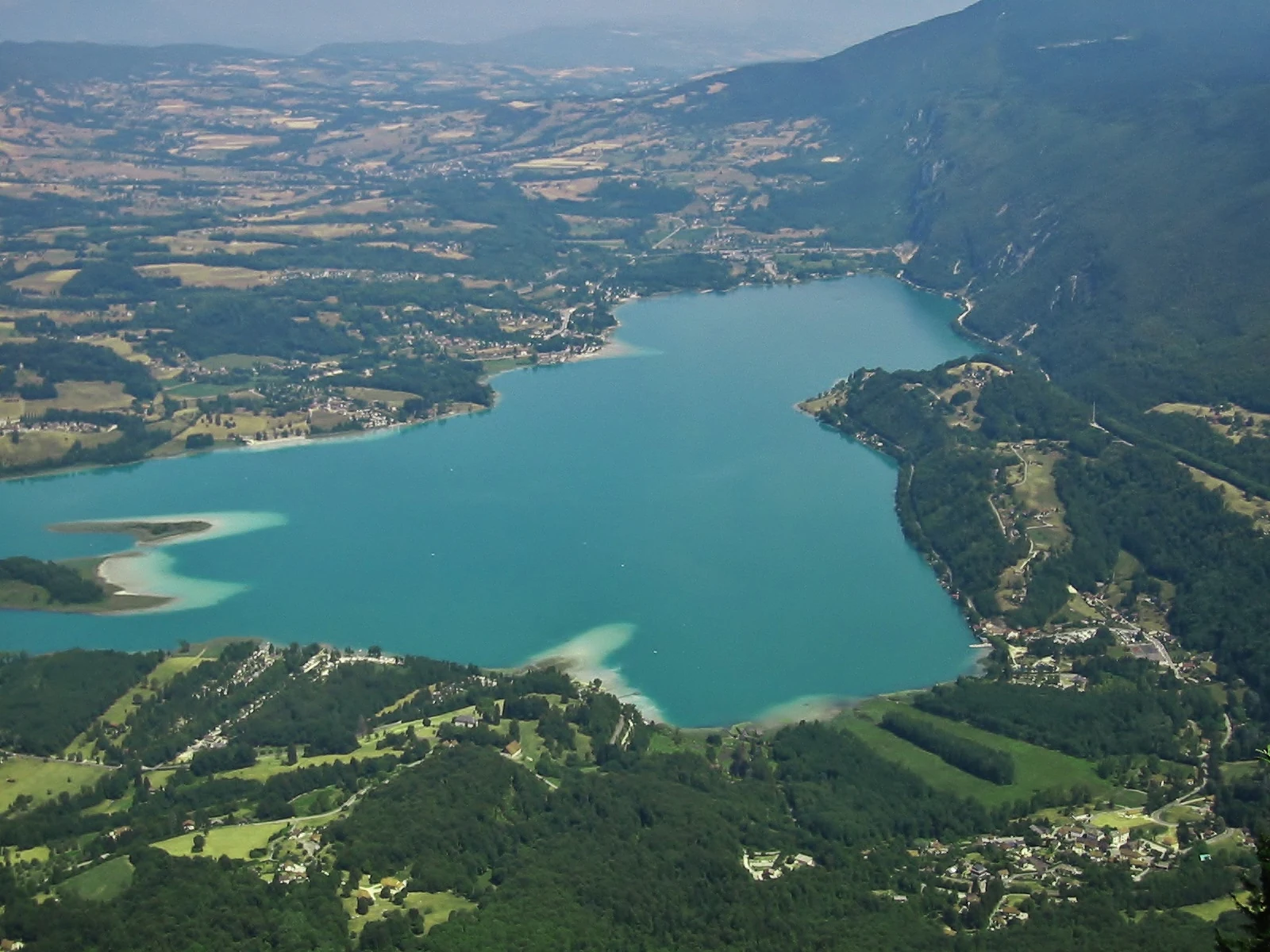
A wide aerial view of the turquoise-colored Lake Aiguebelette surrounded by forested mountains and scattered rural development.
High angle view of Lake Aiguebelette from the surrounding slopes.

Réserve naturelle régionale du lac d'Aiguebelette history and protected-area timeline

The Réserve naturelle régionale du lac d'Aiguebelette was formally created by a deliberation of the Regional Council of Auvergne-Rhône-Alpes on 6 March 2015. It is a regional nature reserve, a French protection category managed at the regional level rather than by the state, and its creation reflects the growing role of French régions in designating protected natural areas. Management responsibility was assigned to the Communauté de communes du Lac d'Aiguebelette, the local intermunicipal authority grouping the lakeside communes. Beyond this founding act, the public history of the reserve is still being built, as the management plan, ecological inventories, and visitor framework continue to be developed in the years following classification.

Réserve naturelle régionale du lac d'Aiguebelette landscape and geographic character

The reserve's landscape is defined by the interplay between a sizeable natural lake and a forested mountain ridge. Lake Aiguebelette occupies a basin set among the Prealps of Savoie, with calm waters bordered by low shores and fringing vegetation. Rising above the lake, the Montagne de l'Épine forms a wooded ridge whose slopes contribute a contrasting terrain of forest and bedrock, giving the protected area a clear two-part structure: open water and shoreline on one side, wooded upland on the other.

This combination creates a compact but varied topographic setting. The lake basin sits at a relatively low elevation, while the slopes of l'Épine rise more steeply, producing transitions between wetland-influenced lakeshore environments and drier, elevation-driven forest habitats. The result is a landscape in which water, woodland, and ridge geography are tightly linked and visible within the boundaries of a single reserve.

Réserve naturelle régionale du lac d'Aiguebelette conservation status and protection priorities

The conservation significance of the Réserve naturelle régionale du lac d'Aiguebelette lies in bringing formal habitat and species management protection to a Prealpine landscape that combines a sizeable natural lake with extensive surrounding forest. Classified under IUCN Category IV, the reserve is officially framed around the conservation of particular habitats and species rather than around broader wilderness or ecosystem-level protection. By encompassing both the lake and part of the Montagne de l'Épine, the reserve aims to maintain ecological connectivity between aquatic and terrestrial environments, an approach that is characteristic of French regional nature reserves and that allows management actions to address shoreline, forest, and upland habitats within a coherent framework. The reserve is administered locally by the Communauté de communes du Lac d'Aiguebelette, which is responsible for implementing the management tools and regulations that accompany its classification.

Top sights and standout views in Réserve naturelle régionale du lac d'Aiguebelette

A defining highlight of the reserve is the pairing of Lake Aiguebelette with the wooded slopes of the Montagne de l'Épine, giving it a landscape identity that shifts easily from lakeshore to forested ridge within a single protected perimeter. Another is its regional nature reserve status, which places its governance with the Communauté de communes du Lac d'Aiguebelette and embeds the site's protection within the local intermunicipal framework of Savoie.

Monthly climate preview

Long term representative point measurements detailing twelve month temperature and precipitation cycles

Climate Normals and Annual Temperature Range for Réserve naturelle régionale du lac d'Aiguebelette

Representative coordinate records show measured monthly temperature variations alongside steady precipitation rates throughout the year at Réserve naturelle régionale du lac d'Aiguebelette. Detailed monthly breakdowns provide complete historical climate norms to support thorough geographic analysis.
Annual mean10 °C
1 °C19 °C
Jan
Feb
Mar
Apr
May13°
Jun17°
Jul19°
Aug19°
Sep15°
Oct11°
Nov
Dec
Warmest month
July

19.4 °C

Coolest month
January

0.9 °C

Wettest month
November

3.3 mm/day

Driest month
March

2.2 mm/day

Park location guide

Geography guide, regional context, and park location map for Réserve naturelle régionale du lac d'Aiguebelette

Réserve naturelle régionale du lac d'Aiguebelette park geography, regions, and map view in France

Understand where Réserve naturelle régionale du lac d'Aiguebelette sits in France through a broader geographic reading of the surrounding landscape, nearby location context, and its mapped position within the national park landscape.

How Réserve naturelle régionale du lac d'Aiguebelette fits into France

France is a unitary semi-presidential republic and one of the world's largest economies. It borders Belgium, Luxembourg, Germany, Switzerland, Italy, Monaco, Andorra, and Spain, with a maritime border to the United Kingdom. The country is known for its cultural influence, art, cuisine, and political history spanning centuries.

Wider geography shaping Réserve naturelle régionale du lac d'Aiguebelette in France

France is located in Western Europe. Metropolitan France extends from the Rhine to the Atlantic Ocean and from the Mediterranean Sea to the English Channel and North Sea. The country borders Belgium, Luxembourg, Germany, Switzerland, Italy, Monaco, Andorra, Spain, and has a maritime border with the United Kingdom.

Map view of Réserve naturelle régionale du lac d'Aiguebelette

Use this park location map to pinpoint Réserve naturelle régionale du lac d'Aiguebelette in France, understand its exact geographic position, and read its mapped placement within the surrounding landscape more clearly.

Pigeon | © OpenStreetMap contributors

Location context for Réserve naturelle régionale du lac d'Aiguebelette

Auvergne-Rhône-Alpes
Recorded earthquake history

Explore Historical Earthquake Records for Réserve naturelle régionale du lac d'Aiguebelette

Examine the history of seismic events identified in the vicinity of the Réserve naturelle régionale du lac d'Aiguebelette. This catalogue provided by MoriAtlas tracks documented earthquakes near the reserve boundaries, offering a clear and transparent view of historical epicentre locations and magnitude metrics for researchers and enthusiasts.

Réserve naturelle régionale du lac d'Aiguebelette Earthquake History

Catalogued events

57 events

Strongest magnitude

Magnitude 4.5

Most recent event

May 6, 2025

This history includes earthquakes recorded inside the park or within 50 km of its borders

Visual exploration of lakeshore habitats, forested mountain ridges, and protected Prealps terrain

Réserve naturelle régionale du lac d'Aiguebelette Landscape Photos and Scenery

Visual documentation captures the stark contrast between deep glacial waters and the steep forested slopes of the Montagne de l'Épine. Examining these protected habitats and shoreline environments provides a clear understanding of the ecological geography within the Savoie Prealps.

A wide aerial view of the turquoise-colored Lake Aiguebelette surrounded by forested mountains and scattered rural development.

Park atlas

Compare adjacent protected landscapes, mountain ridges, and glacial lake basins in Savoie

Explore Parks Near Réserve naturelle régionale du lac d'Aiguebelette and Surrounding Prealps

Browse nearby protected areas sharing similar alpine terrain and water features with Réserve naturelle régionale du lac d'Aiguebelette. Comparing surrounding regional reserves provides broader context on northern Prealps conservation geography.
A soft watercolor painting depicting a wide river flowing through a lush green landscape with distant rolling purple hills in the background.
Nature reserveAuvergne-Rhône-Alpes
About 13 km away#1 closest

Northwest

Rhône du Pont de Groslée à Murs-et-Gélignieux: Alluvial Nature Reserve & River Geography

Protected riparian habitat in Auvergne-Rhône-Alpes, France.

Analyze the complex fluvial dynamics of the Rhône du Pont de Groslée à Murs-et-Gélignieux nature reserve. This site features a well-preserved landscape of alder and ash floodplain forests, isolated side channels, and marshy meadows that provide an essential ecological corridor through the Rhône river valley.

Area
21.05 km²
Relief
Lowland
Scope
Terrestrial
Water
Water-dominated
Nature reserveAuvergne-Rhône-Alpes
About 32 km away#2 closest

Northwest

Réserve naturelle régionale des étangs de Mépieu: Atlas and Geographic Protected Area Overview

Wetlands, peatlands, and dry grasslands in northern Isère

The Réserve naturelle régionale des étangs de Mépieu offers a striking study in ecological contrast. This protected landscape contains a dense mosaic of five ponds and marshy terrain set directly against sun-exposed dry grasslands and heathland slopes. The site serves as a vital corridor for migratory birds and rare flora within the rolling countryside of the Auvergne-Rhône-Alpes region.

Area
1.618 km²
Established
2008
IUCN
IV
Relief
Lowland
A horizontal watercolor painting depicting a gentle mountain silhouette behind a forested shoreline sloping toward the water.
Nature reserveFrance
About 41 km away#3 closest

Northeast

Roc de Chère Nature Reserve: Mapping the Botanical Diversity and Geological Features of Haute-Savoie

A protected alpine promontory bordering Lake Annecy

Roc de Chère stands as a distinct geological landmark where limestone and sandstone soils create sharp microclimate contrasts. This protected reserve provides a critical habitat for diverse plant species and rare dragonflies within a small, defined area of the French Alps. The site acts as a key element of the Lake Annecy landscape, offering insight into the post-glacial environmental history of the Savoie region through its protected cliffs and hollows.

Area
0.69 km²
Established
1977
Relief
Mountain
Climate
Temperate
A pale, soft watercolor illustration showing a horizontal landscape of a pond and wetlands bordered by trees, with faint mountain silhouettes in the distance.
Nature reserveIsère
46 km away#4 closest

South

Réserve naturelle régionale de l'étang de Haute-Jarrie, Isère Protected Wetland Landscape

Regional nature reserve and migratory bird sanctuary

Situated on the Plateau de Champagnier in Isère, this regional nature reserve offers a concentrated example of glacial pond ecology and wetland biodiversity. Covering 11 hectares, it acts as a critical stopover within the Grésivaudan valley migratory corridor. This protected site features diverse habitats, including reedbeds and wet meadows, that support hundreds of recorded bird species and a variety of dragonflies and amphibians, making it a significant area for ecological study.

Area
0.11 km²
Established
2008
IUCN
IV
Relief
Upland
A soft watercolor painting of a wetland landscape featuring a central pond, surrounding reeds, and distant rolling hills in pale green and pink hues.
Nature reserveAuvergne-Rhône-Alpes
About 47 km away#5 closest

West

Réserve naturelle régionale de l'étang de Saint-Bonnet: Wetland Atlas and Map Discovery

Examining protected wetland geography in the Isère department

This protected area centers on the étang de Saint-Bonnet, a wetland habitat defined by dense reedbeds and pond-centered ecosystems. It provides a distinct example of nature conservation situated between major urban corridors, showcasing how amphibians and diverse bird communities thrive within a small, managed lowland basin.

Area
0.514 km²
Established
1987
IUCN
IV
Relief
Lowland
A soft watercolor painting depicting a winding river through a lush green valley with distant hills in the background.
Nature reserveAuvergne-Rhône-Alpes
About 49 km away#6 closest

South

Réserve naturelle régionale des Isles du Drac: Braided River Landscape and Regional Map Context

A vital riverine conservation corridor in the Auvergne-Rhône-Alpes region of France

The Réserve naturelle régionale des Isles du Drac occupies an expansive alluvial floodplain where the river transitions into a braided system. This reserve preserves dynamic gravel bars and woodland habitats that support exceptional biodiversity within the northern Alpine landscape. It offers a detailed look at how riverine corridors persist alongside significant hydroelectric and industrial infrastructure in the Grenoble area.

Area
8.048 km²
Established
2009
IUCN
IV
Relief
Lowland
Watercolor painting of a soft green alpine landscape with rolling hills, a central body of water, and evergreen trees against a light mountain background.
Nature reserveSavoie
About 59 km away#7 closest

Northeast

Réserve naturelle régionale de la tourbière des Saisies - Beaufortain - Val d'Arly Protected Area Map

High-altitude peatland geography in the Savoie department.

Investigate the complex topography and conservation significance of the Réserve naturelle régionale de la tourbière des Saisies - Beaufortain - Val d'Arly. This protected area stands as a unique alpine landmark, recognized for its subalpine boreal vegetation, rich bird populations, and critical role as a regional peatland sanctuary within the Savoie mountain range.

Area
2.93 km²
Established
2013
IUCN
IV
Watercolor illustration showing mountains, a winding river, and pine trees in a landscape
National parkFrance
63 km away#8 closest

Southeast

Écrins National Park: Alpine Glaciated Terrain and Protected Landscape Details

Mapped boundaries and regional geography of a major French National Park.

Delve into Écrins National Park, a defining national park within the French Alps. This page provides a comprehensive overview of its protected landscape, focusing on its dramatic glaciated terrain, significant peaks such as the Barre des Écrins, and its position within the regional geographic context. Explore the mapped extent and understand the unique alpine environment of this protected area.

Area
925 km²
Established
1973
IUCN
II
Visitors
800K annual

Common questions about visiting, size, designation, and location context for Réserve naturelle régionale du lac d'Aiguebelette

Réserve naturelle régionale du lac d'Aiguebelette FAQs for park facts, access, geography, and protected area context

Find quick answers about Réserve naturelle régionale du lac d'Aiguebelette, including protected-area facts, park geography, trail and visitor context, and how the park fits into its surrounding country and regional landscape.
MoriAtlas Explorer

Continue Your Protected Areas Search Across the Global Atlas

Deepen your exploration by continuing the structured search for national parks and protected areas worldwide. Utilize the comprehensive filtering capabilities to compare different conservation landscapes and refine your understanding of global park geography. Discover more about the distribution and characteristics of protected natural areas.

Global natural geography