
Mori Atlas logo
Nature reserveRéserve naturelle régionale du marais de Stors

A preserved marshland landscape and vital ecological enclave in the Vallée de Chauvry

Réserve naturelle régionale du marais de Stors: Mapping Protected Wetlands in Île-de-France

The Réserve naturelle régionale du marais de Stors acts as a key protected wetland refuge, showcasing unique hydrological features within the densely populated landscape of the Île-de-France region. This site provides a critical window into the natural history of the Vallée de Chauvry, preserving a marshland habitat that serves as a representative example of regional biodiversity conservation efforts in northern France.

wetlandmarshlandregional nature reserveÎle-de-FranceVal-d'OiseVallée de Chauvry
A graphic illustration depicting a valley with tall, stylized pine trees in the foreground, a winding river, and distant mountains with a waterfall, rendered in a palette of pastel pinks, greens, and yellows.

Réserve naturelle régionale du marais de Stors

Nature reserve

Park overview

Structured park overview, official facts, and landscape profile for Marais de Stors Regional Nature Reserve

Marais de Stors Regional Nature Reserve park facts, protected area profile, and essential visitor context

Review the core facts for Marais de Stors Regional Nature Reserve, including designation, size, terrain, visitor scale, habitats, and operating context in one park-focused overview.

About Marais de Stors Regional Nature Reserve

The Marais de Stors Regional Nature Reserve sits within the commune of Mériel, in the Val-d'Oise department of the Île-de-France region, northwest of central Paris. The territory belongs to the Vallée de Chauvry, a small rural valley that preserves some of the natural landscape character that has elsewhere been lost in this densely populated part of France. Despite its modest size of roughly 47 hectares, the reserve plays an outsize role as a protected fragment of wetland habitat in a region where surviving marshlands are increasingly rare.

The reserve is classified internationally under IUCN Category IV, which corresponds to habitat and species management areas. This category reflects the site's purpose of maintaining particular wetland conditions and the species that depend on them, rather than acting as a strict wilderness reserve. The reserve's boundary was first established in 2009, and a follow-up regional deliberation in 2012 refined the list of included parcels, indicating an ongoing process of delimitation and management refinement.

Administration is handled by the Agence des espaces verts de la région d'Île-de-France, a regional agency entrusted with managing green spaces, forests, and natural areas across the Île-de-France region. This stewardship is particularly meaningful for the Marais de Stors because it places the site within a coordinated regional strategy for ecological connectivity and conservation at a scale that complements larger national parks and nature reserves elsewhere in France.

In geographic context, the reserve sits in a transitional zone between suburban communities along the northern edge of the Paris metropolitan area and more rural countryside further northwest. Its presence provides a small but valuable counterpoint to the otherwise heavily developed landscape, offering a local example of how targeted conservation initiatives can preserve distinctive natural environments even in densely inhabited regions.

Quick facts and research context for Marais de Stors Regional Nature Reserve

The Marais de Stors is a French regional nature reserve located in the commune of Mériel, in the Val-d'Oise department of the Île-de-France region. It occupies an area of about 47 hectares within the Vallée de Chauvry, a small valley landscape northwest of Paris. The reserve was formally created by regional deliberation on 9 July 2009, and a later deliberation in November 2012 clarified the specific land parcels included in the boundaries.

Under the IUCN protected-area framework, the site is classified as Category IV, a designation aimed at the ongoing management and conservation of habitats and species. The reserve is administered by the Agence des espaces verts de la région d'Île-de-France, which is responsible for stewardship, management planning, and conservation oversight of the site. Its relatively small size and focused wetland setting make it a locally significant conservation area rather than a large-scale wilderness reserve.

Protection and recognition

Explore documented conservation status, designation records, and WDPA reference details.

Protection Status and International Recognition Data for Réserve naturelle régionale du marais de Stors

Examine documented protection metrics, administrative scope, and official designation records associated with Réserve naturelle régionale du marais de Stors. Structured conservation data provides reliable reference points for evaluating international recognition frameworks and protected area boundaries.

Protection details

WDPA ID
555514374
Park context

Deeper park guide and search-rich context for Marais de Stors Regional Nature Reserve

Marais de Stors Regional Nature Reserve history, landscape, wildlife, and travel context

Explore Marais de Stors Regional Nature Reserve through its history, landscape character, ecosystems, wildlife, conservation priorities, cultural context, and seasonal travel timing in a structured park guide built for atlas discovery and search intent.

Why Marais de Stors Regional Nature Reserve stands out

The Marais de Stors is known primarily for preserving a rare surviving patch of natural marshland within the densely populated Île-de-France region. Its ecological significance lies in the persistence of wet habitat conditions and associated biodiversity in a landscape pocket of the Vallée de Chauvry, an area characterized historically by small valleys and waterlogged ground. Because most of the surrounding region has been converted to agricultural or urban uses, the reserve has local importance as a refuge for wetland flora and fauna and as a representative example of the kinds of marshland environments that once occurred more widely in the northern Paris basin.
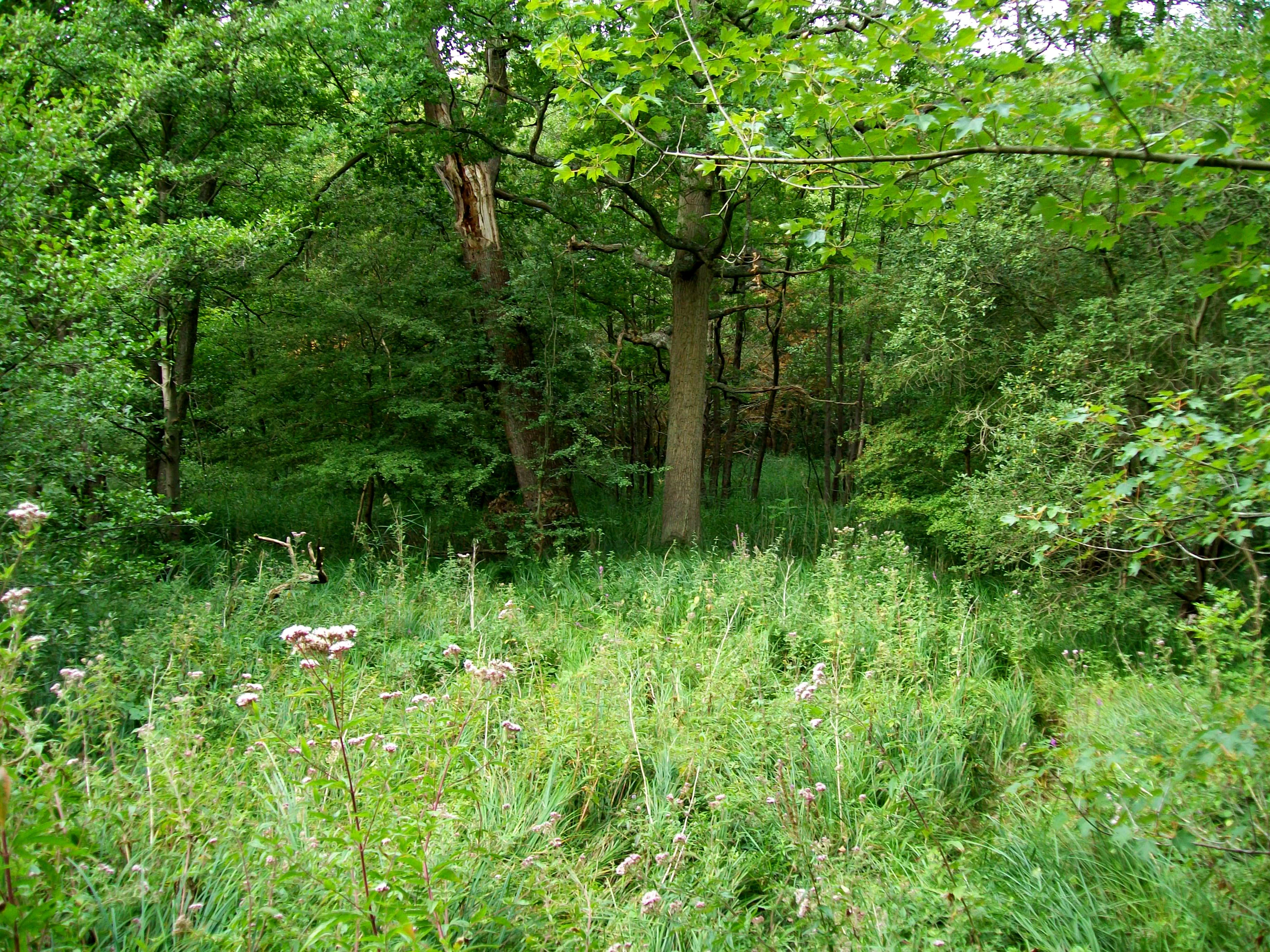
A dense, green forest scene in summer with tall grasses and flowering plants in the foreground, leading into a shaded woodland area.
Lush vegetation and deciduous forest within the Stors marsh area.

Marais de Stors Regional Nature Reserve history and protected-area timeline

The Marais de Stors gained formal protection in 2009, when the regional authorities of Île-de-France classified the site as a regional nature reserve through a deliberation dated 9 July 2009. This classification marked a commitment to long-term protection of the site's wetland character.

In 2012, a subsequent deliberation dated 21 November refined the practical boundary of the reserve by clarifying the specific land parcels included within the protected perimeter. This adjustment reflects typical administrative development for new regional nature reserves in France, where initial designation is often followed by fine-tuning of boundaries and management arrangements.

Since its creation, the reserve has been managed by the Agence des espaces verts de la région d'Île-de-France, a public agency responsible for natural-area stewardship across the region. The relatively recent establishment of the reserve means it is best understood as a young conservation initiative whose significance continues to develop as ecological management efforts mature.

Marais de Stors Regional Nature Reserve landscape and geographic character

The landscape of the Marais de Stors is defined by its character as a small, low-lying wetland within the Vallée de Chauvry. The valley context suggests gently undulating terrain typical of the small tributary valleys found northwest of Paris, with the reserve occupying the flat, waterlogged ground at the bottom of this broader landscape unit.

Wetland features dominate the reserve's physical environment. Marsh soils, seasonal or permanent surface water, and marshland vegetation patterns shape both the scenic character and the hydrological functioning of the site. Surrounding the reserve, the landscape transitions into the mixed agricultural, forested, and suburban land uses typical of the outer Île-de-France, making the marsh an enclave of distinctive wet habitat within a more heavily modified regional setting.

The topography, soils, and water regime of the area together create the conditions that make the site valuable ecologically, differentiating it from the drier, cultivated, or built-up land that surrounds it.

Marais de Stors Regional Nature Reserve ecosystems, habitats, and plant life

As a regional nature reserve, the Marais de Stors is recognized for its ecological importance within the regional context of Île-de-France. The site's value lies in the preservation of wetland habitat, which is increasingly scarce across the heavily developed northern Paris basin.

Marshland environments such as this typically support distinctive vegetation communities adapted to saturated soils, as well as associated invertebrate, amphibian, and bird populations. Although detailed species information for the reserve is not extensively documented in available sources, the site's classification under IUCN Category IV reflects an active management approach aimed at maintaining the habitats and species that depend on the wetland's continued presence.

The reserve's ecological role is also tied to its position within a broader regional landscape that includes agricultural land, woodland fragments, and suburban development. This setting gives the site added significance as a refuge and stepping stone for wetland-associated biodiversity in a region where natural marsh areas have largely disappeared.

Marais de Stors Regional Nature Reserve wildlife and species highlights

The Marais de Stors is protected primarily as a wetland habitat, and its wildlife value is closely tied to the persistence of marshland conditions. Such environments in the Île-de-France context typically support invertebrates adapted to wet soils, amphibians that breed in shallow standing water, and birds associated with marsh and wetland edge habitats.

While detailed species inventories for the reserve are not available in the source material, the site's designation as a managed habitat and species area implies an emphasis on maintaining conditions favorable to these wetland-dependent groups. The reserve's small size and embedded position within a working landscape suggest that its wildlife function also includes supporting local ecological networks, where marshland species can persist in close proximity to more intensively used surrounding land.

This wildlife profile gives the reserve its character as a small but ecologically meaningful refuge for wetland-associated fauna in a region where such habitats are limited.

Marais de Stors Regional Nature Reserve conservation status and protection priorities

The Marais de Stors Regional Nature Reserve was created in 2009 to protect a remaining example of wetland habitat in the Val-d'Oise department of Île-de-France. Within the regional context, where most natural landscapes have been substantially altered by agriculture, forestry, suburban development, and the expansion of the Paris metropolitan area, the reserve represents a deliberate effort to maintain a piece of functioning marshland ecosystem.

The reserve is classified under IUCN Category IV and managed by the Agence des espaces verts de la région d'Île-de-France, a regional agency with responsibility for green space and biodiversity stewardship. This institutional framework supports active management, monitoring, and habitat maintenance, rather than purely passive protection.

Beyond its local value, the reserve contributes to broader regional conservation goals by preserving habitat heterogeneity, supporting wetland-associated species, and providing a small natural area within an otherwise heavily modified landscape. Its existence reflects the role of France's regional nature reserve network in protecting smaller but ecologically important sites that complement the country's larger national parks and nature reserves.

Top sights and standout views in Marais de Stors Regional Nature Reserve

The reserve's standout qualities include its status as a preserved wetland enclave within a heavily urbanized region, its formal establishment under the French regional nature reserve system, and its active management by a dedicated regional agency. Its small scale and focused wetland character make it a representative example of targeted local conservation in continental Europe.

The combination of formal protection, clear institutional stewardship, and a distinct wetland ecological identity gives the Marais de Stors a clearly defined conservation profile within the broader network of French protected areas.
Monthly climate preview

Long-term temperature ranges and monthly precipitation records derived from representative coordinate sampling

Climate Normals and Annual Weather Patterns at Réserve naturelle régionale du marais de Stors

Representative coordinate measurements reveal the multiyear temperature progression and monthly precipitation rhythm across Réserve naturelle régionale du marais de Stors between 1991 and 2020. Examining the complete twelve-month statistical profile provides detailed context for analyzing long-term climate normals at this protected location.
Annual mean11 °C
3 °C19 °C
Jan
Feb
Mar
Apr10°
May14°
Jun17°
Jul19°
Aug19°
Sep16°
Oct11°
Nov
Dec
Warmest month
July

19.3 °C

Coolest month
January

3 °C

Wettest month
December

2.3 mm/day

Driest month
April

1.5 mm/day

Park location guide

Geography guide, regional context, and park location map for Marais de Stors Regional Nature Reserve

Marais de Stors Regional Nature Reserve park geography, regions, and map view in France

Understand where Marais de Stors Regional Nature Reserve sits in France through a broader geographic reading of the surrounding landscape, nearby location context, and its mapped position within the national park landscape.

How Marais de Stors Regional Nature Reserve fits into France

France is a unitary semi-presidential republic and one of the world's largest economies. It borders Belgium, Luxembourg, Germany, Switzerland, Italy, Monaco, Andorra, and Spain, with a maritime border to the United Kingdom. The country is known for its cultural influence, art, cuisine, and political history spanning centuries.

Wider geography shaping Marais de Stors Regional Nature Reserve in France

France is located in Western Europe. Metropolitan France extends from the Rhine to the Atlantic Ocean and from the Mediterranean Sea to the English Channel and North Sea. The country borders Belgium, Luxembourg, Germany, Switzerland, Italy, Monaco, Andorra, Spain, and has a maritime border with the United Kingdom.

Map view of Marais de Stors Regional Nature Reserve

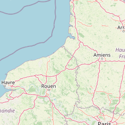
Use this park location map to pinpoint Marais de Stors Regional Nature Reserve in France, understand its exact geographic position, and read its mapped placement within the surrounding landscape more clearly.

Pigeon | © OpenStreetMap contributors

Location context for Marais de Stors Regional Nature Reserve

Île-de-France

Visual reference collection showcasing marshland habitats and valley terrain

Réserve naturelle régionale du marais de Stors Photos and Landscape Scenery

Photographic records capture the distinct wetland environment and waterlogged terrain preserved within the Vallée de Chauvry. Visual exploration reveals the ecological character of this protected marshland enclave situated across northern France.

A dense, green forest scene in summer with tall grasses and flowering plants in the foreground, leading into a shaded woodland area.

Park atlas

Compare surrounding regional reserves and connected wetland conservation landscapes

Explore Protected Areas and Parks Near Réserve naturelle régionale du marais de Stors

Browse other protected areas located near Réserve naturelle régionale du marais de Stors to compare regional wetland habitats and valley ecosystems. Examining these adjacent conservation zones provides broader geographic context across the northern Paris basin.
Nature reserveÎle-de-France
About 22 km away#1 closest

West

Réserve naturelle régionale du site géologique de Vigny-Longuesse: A Geological Reference Site

Protected limestone landscape in the Vexin region of Île-de-France

Protecting a critical paleontological and stratigraphic record, this reserve showcases a unique Tertiary reef complex. The site combines artificial quarry cliffs with natural geomorphological features, including paleolandslides and fossil-bearing limestone plates, providing a comprehensive outdoor archive of the Paris Basin.

Area
0.219 km²
Established
2009
IUCN
IV
Relief
Upland
Nature reserveÎle-de-France
About 36 km away#2 closest

West

Réserve naturelle régionale du site géologique de Limay: Protected Landscapes and Geological Maps

A diverse nature reserve in the Yvelines department of Île-de-France.

Deeply rooted in the geological history of the Paris Basin, this former quarry site in Limay is now a thriving regional nature reserve. Its compact territory features a striking contrast between ancient limestone exposures and rich wetland pockets, providing a vital educational platform for studying biodiversity and land reclamation in north-central France.

Area
0.698 km²
Established
2009
IUCN
IV
Relief
Lowland
A horizontal watercolor illustration showing a calm river winding around small tree-covered islands with low hills in the distance.
Nature reserveÎle-de-France
About 36 km away#3 closest

Southeast

Réserve naturelle régionale des îles de Chelles: Protected River Islands in Île-de-France

Wetland ecosystems and riparian landscape geography

Located on the Marne River, this protected regional nature reserve encompasses a series of river islands known for their rich wetland biodiversity. The site offers a unique geographic perspective on urban-adjacent conservation, featuring a mosaic of riparian thickets and hygrophilous flora that contrasts with the surrounding Seine-et-Marne landscape.

Area
0.05 km²
Established
2008
IUCN
IV
Relief
Lowland
A soft, painterly watercolor illustration depicting a winding river flowing through a green basin with rolling hills, grasses, and scattered trees under a light sky.
Nature reserveÎle-de-France
About 38 km away#4 closest

South

Réserve naturelle régionale du bassin de la Bièvre: Protected Wetland and Basin Geography

A vital urban nature reserve within the Île-de-France region

Located south of Paris, this six-hectare nature reserve demonstrates how an artificial stormwater basin can evolve into a functioning wetland. Its geography is defined by fluctuating water levels and reedbed habitats that provide sanctuary for migratory birds. Examine the protected boundaries and landscape terrain of this significant, compact ecological refuge in the Bièvre valley.

Area
0.06 km²
Established
2009
IUCN
IV
Relief
Lowland
Watercolor painting of a wide, soft green landscape featuring rolling hills, scattered trees, and meadows under a warm sky.
Nature reserveÎle-de-France
About 42 km away#5 closest

West

Réserve naturelle régionale de la boucle de Moisson: Protected Seine Meander and Plain

Regional Nature Reserve in Île-de-France

Located in the Yvelines department, this protected area occupies a striking loop of the Seine river. The reserve preserves a blend of open meadow plains and birch-rich woodlands, offering insight into river valley geography and local landscape patterns within the Île-de-France basin.

Area
3.163 km²
Established
2009
IUCN
IV
Nature reserveÎle-de-France
About 44 km away#6 closest

South

Réserve naturelle régionale du val et coteau de Saint-Rémy: Regional Nature Reserve Geography

A protected river valley and coteau habitat in Île-de-France

Spanning eighty-three hectares across five distinct parcels, this protected area serves as a vital ecological corridor along the Yvette river. Analyze the site's unique habitat distribution, ranging from moist bottomlands to dry, calcareous slopes, and trace its role in preserving regional biological diversity near Saint-Rémy-lès-Chevreuse.

Area
0.83 km²
Established
2008
IUCN
IV
A watercolor painting showing a rolling rural landscape with green hills, scattered trees, and a light sky.
Nature reserveHauts-de-France
About 51 km away#7 closest

Northwest

Réserve naturelle régionale des Larris et tourbières de Saint-Pierre-es-Champs Protected Area Geography

Regional nature reserve and limestone promontory in northern France

Understand the ecological and geological significance of the Réserve naturelle régionale des Larris et tourbières de Saint-Pierre-es-Champs. This site showcases a rare juxtaposition of dry chalk slopes and damp peatland habitats that characterize the local geography of the Pays de Bray, offering insight into the preservation of semi-natural landscapes through traditional conservation grazing practices.

Area
0.794 km²
Established
1992
IUCN
IV
Watercolor painting of a gentle, winding river or pond flowing through a green meadow with soft, rolling hills in the background under a pale sky.
Nature reserveÎle-de-France
About 54 km away#8 closest

South

Réserve naturelle régionale des étangs de Bonnelles: Regional Nature Reserve Geography

Wetland ecosystem analysis in the Yvelines department.

Defined by its two core ponds, this regional nature reserve creates a critical mosaic of wetland, marsh, and woodland habitats. It stands out in the Île-de-France area as a concentrated zone of freshwater biodiversity, supporting a variety of avian and invertebrate life in a region where such undisturbed watery terrain is limited.

Area
0.221 km²
Established
1990
IUCN
IV
Relief
Lowland

Common questions about visiting, size, designation, and location context for Marais de Stors Regional Nature Reserve

Marais de Stors Regional Nature Reserve FAQs for park facts, access, geography, and protected area context

Find quick answers about Marais de Stors Regional Nature Reserve, including protected-area facts, park geography, trail and visitor context, and how the park fits into its surrounding country and regional landscape.
MoriAtlas Explorer

Continue Your Protected Areas Search Across the Global Atlas

Deepen your exploration by continuing the structured search for national parks and protected areas worldwide. Utilize the comprehensive filtering capabilities to compare different conservation landscapes and refine your understanding of global park geography. Discover more about the distribution and characteristics of protected natural areas.

Global natural geography