Mori Atlas logo
Nature reserveMarais de Taligny Regional Nature Reserve

A critical study of alluvial terrain and rare alkaline fen habitats in the Négron valley

Mapping Marais de Taligny Regional Nature Reserve and its Protected Wetland Landscapes

(Réserve naturelle régionale du marais de Taligny)

The Marais de Taligny Regional Nature Reserve preserves a unique mosaic of reed beds, peat meadows, and alluvial woodlands along the Négron river basin. This protected area in Centre-Val de Loire showcases the complex geography of rehumidified marshes; offering insights into the ongoing renaturation of historic French wetlands and the recovery of threatened aquatic habitats.

wetlandmarshalkaline fenregional nature reserveIndre-et-LoireLoire valley

Marais de Taligny Regional Nature Reserve

Nature reserve

Park overview

Structured park overview, official facts, and landscape profile for Marais de Taligny Regional Nature Reserve

Marais de Taligny Regional Nature Reserve park facts, protected area profile, and essential visitor context

Review the core facts for Marais de Taligny Regional Nature Reserve, including designation, size, terrain, visitor scale, habitats, and operating context in one park-focused overview.

About Marais de Taligny Regional Nature Reserve

The Marais de Taligny Regional Nature Reserve protects a stretch of wetland in the lower Négron valley, in the rural Indre-et-Loire countryside between Chinon and the Vienne river. Although modest in size, the site represents one of the few remaining places in central France where the original alkaline fen ecosystems of the Loire basin still survive in any recognizable form.

For centuries the valley floor at the Taligny locality held one of the largest marshlands of Touraine. It functioned as a permanent wetland with seasonal flooding, and was occasionally grazed. Early botanical surveys, notably those by Tourlet in the early 1900s, highlighted its rich and unusual flora, with plants typical of bas-marais alcalins, peat meadows, and riverside alluvial woods.

In 1975 the commune of La Roche-Clermault, then the principal landowner, undertook drainage works in partnership with the National Forestry Office to convert the site into a poplar plantation. The Négron was diverted along the edges of the marsh, and its former bed became a central drainage ditch. A 1992 storm destroyed most of the poplar plantation, leaving the wetland in a degraded but still recoverable state. Despite repeated drying episodes, the underlying marsh conditions persisted.

Recognizing the site's continuing biodiversity value and the rarity of its alkaline communities in the region, authorities added layered protections: an Espace Naturel Sensible designation in 2012 covering roughly 85 hectares of valley floor, and a formal Regional Nature Reserve status in 2014 covering the core 19.74 hectares. In 2022 the reserve was enlarged to 35.39 hectares and its regulations were updated. The site is now the focus of an active renaturation program aimed at rewetting the marsh and reopening overgrown habitats.

Quick facts and research context for Marais de Taligny Regional Nature Reserve

The Marais de Taligny Regional Nature Reserve (registry code RNR271) sits in the communes of La Roche-Clermault and Seuilly, at the downstream end of the Négron watershed in Indre-et-Loire. It was created by regional decree in February 2014 and expanded in March 2022 to a current area of about 35 hectares, with the surrounding valley floor protected as an Espace Naturel Sensible covering roughly 85 hectares. Classified under IUCN Category IV as a habitat and species management area, the reserve is also a designated ZNIEFF (240030193).

Protection and recognition

Documented terrestrial protection scope, designation year, and official management records

Marais de Taligny Regional Nature Reserve Protection Status and Designation History

Marais de Taligny Regional Nature Reserve maintains a documented terrestrial protection status established in the year 2022. This structured overview compiles official designation records and management scope details for the protected landscape.

Protection details

Protection scope
Terrestrial
Designated year
2022
Transboundary protection
No
WDPA ID
555597222
Park context

Deeper park guide and search-rich context for Marais de Taligny Regional Nature Reserve

Marais de Taligny Regional Nature Reserve history, landscape, wildlife, and travel context

Explore Marais de Taligny Regional Nature Reserve through its history, landscape character, ecosystems, wildlife, conservation priorities, cultural context, and seasonal travel timing in a structured park guide built for atlas discovery and search intent.

Why Marais de Taligny Regional Nature Reserve stands out

The reserve is best known for surviving alkaline low-marsh formations (bas-marais alcalins), which have become extremely rare in the Centre-Val de Loire region. These calcium-rich wetlands, originally described by botanist E. Tourlet in the early twentieth century, support a distinctive plant community dominated by marisque (Cladium mariscus) and historically by Molinia caeruleae meadows. The site also stands out for its dense reed beds, diverse dragonfly and butterfly populations, and the presence of regionally threatened mammals such as the European beaver and the water vole.

Marais de Taligny Regional Nature Reserve history and protected-area timeline

Until the mid-twentieth century, the valley of the Négron at the Taligny locality supported one of the largest marshes of Touraine. It was a permanent marsh used at times for grazing, and noted at the turn of the century by the botanist E. Tourlet for its exceptional flora and fauna, especially bas-marais alcalins and peat meadow communities, habitats that were already rare in what is now Centre-Val de Loire.

The marsh fell into neglect in the following decades and in 1975 the commune of La Roche-Clermault, the principal landowner, began a drainage and plantation project in cooperation with the French National Forestry Office, aiming to convert the wetland to poplar production. The works diverted the Négron along the perimeter of the site, turning its former central bed into a drainage ditch, and changed the hydrology of the whole valley.

A 1992 storm significantly damaged the poplar plantation, and although the periodic drying of the marsh had reduced its ecological richness, the site remained flood-prone and continued to host rare species and a residual alkaline fen. This combination of conservation interest and ongoing environmental pressure led first to an Espace Naturel Sensible designation in September 2012, then to the formal creation of the Regional Nature Reserve in February 2014. A 2022 regional deliberation increased the reserve's area and revised its regulations, and an ongoing renaturation operation seeks to restore natural water flows, rebuild aquatic habitat diversity, and rehabilitate the historic low-marsh vegetation.

Marais de Taligny Regional Nature Reserve landscape and geographic character

The Marais de Taligny lies at the downvalley end of the Négron basin, a small left-bank tributary of the Vienne that flows from south to north. The reserve occupies the flat, low-lying valley floor, where the historic bed of the Négron was converted into a central drainage ditch after 1975, while the diverted modern course runs along the edges of the site, crossing a small bridge-canal.

The terrain is predominantly alluvial, with a mosaic of periodically flooded grasslands, open water channels, and patches of woodland. Reeds and tall sedges dominate much of the central marsh, while the borders are marked by degraded but recovering alluvial formations of alder, ash and willow that stabilize the banks and filter incoming water. The contrast between wide, open wetland and narrow riparian woodland gives the site a visually distinct character within an otherwise gently rolling rural landscape.

Marais de Taligny Regional Nature Reserve ecosystems, habitats, and plant life

The reserve is defined ecologically by its wetland habitats, with reed beds, sedge communities, and patches of alkaline low marsh at its core. Several types of reed bed vegetation dominate large areas, including reed canary grass beds, large sedge stands, tall stands of common reed, and Glyceria maxima reedbeds, which play an important role in purifying water flowing through the site. Aquatic pioneer communities of charophyte algae occupy some of the open water channels.

The original flora of alkaline fens is still partially represented, most notably in a marisque-dominated community classified as having regional heritage value, while the once-extensive Molinia caeruleae low-marsh is reduced to a vestigial state. Eutrophic and mesotrophic megaphorbiaia communities line the watercourses, the latter hosting regionally protected species such as yellow meadow rue (Thalictrum flavum) and hairy spurge (Euphorbia villosa). Although these systems were damaged by drainage and by nutrient enrichment from the Négron, the surviving fragments remain exceptional for the region.

Marais de Taligny Regional Nature Reserve wildlife and species highlights

Despite its small size, the Marais de Taligny supports a wide range of fauna typical of French lowland wetlands. Six amphibian species have been recorded, including the common toad, agile frog, green frog, European tree frog, palmate newt and spiny toad, and six reptile species are known or expected, including the western green lizard, grass snake, and slow worm. No strictly aquatic snakes have been observed in the marsh.

The insect fauna is exceptionally rich for a site of this scale, with roughly 77 recorded species. These include 22 butterflies, 27 dragonflies and damselflies (notably the protected Mercury damselfly, Coenagrion mercuriale), and 28 species of orthopterans and dictyopterans. The reserve is also important for birds, hosting protected or heritage species such as the whinchat, the European kingfisher, the red-backed shrike, the spotted flycatcher, and the purple heron.

Among terrestrial mammals, 19 species have been identified, four of which are considered rare or threatened in Centre-Val de Loire: the European beaver, the stoat, the southwestern water vole, and the Eurasian water shrew. The site serves as a hunting territory for bats, with 17 species recorded; pipistrelles dominate, alongside the western barbastelle and the whiskered bat. In the Négron itself, regionally rare or threatened fish species include pike, bitterling, European eel, and bullhead.

Marais de Taligny Regional Nature Reserve conservation status and protection priorities

The conservation interest of the Marais de Taligny rests on the persistence, despite decades of drainage, of alkalinerich wetland habitats that have largely disappeared elsewhere in the Centre-Val de Loire region. Its surviving bas-marais alcalin formations, peat-influenced plant communities, and dense reed beds give it regional, and in some cases national, heritage significance for wetland biodiversity.

Protection combines overlapping frameworks: a Regional Nature Reserve designation, a departmental Espace Naturel Sensible covering a larger valley footprint, and ZNIEFF recognition for its ecological interest. The management plan emphasizes active rewetting of the marsh, hydraulic works on the Négron and its ditches to restore natural flows without worsening flood risk, the reopening of overgrown spaces, and diversification of the pond network to support aquatic invertebrates and amphibians. The aim is to rebuild a functional wetland mosaic that can support the full range of plant and animal species historically associated with this type of valley.

Marais de Taligny Regional Nature Reserve cultural meaning and human context

The Négron valley at Taligny carries a long history of human use. The river was traditionally used to power watermills, and the surrounding valley served rural and pastoral communities of Touraine for centuries. The transformation of the marsh into a poplar plantation in the late twentieth century was part of a broader pattern of draining French lowland wetlands for forestry, an approach later reversed as their ecological value became clearer. The current reserve reflects the contemporary shift in rural land management in the Loire region, where former modified landscapes are being restored as protected natural heritage.

Top sights and standout views in Marais de Taligny Regional Nature Reserve

What sets the Marais de Taligny apart is the survival of alkaline low-marsh vegetation that has otherwise vanished from much of central France, combined with a dense mosaic of reed beds, alluvial woodland, and open water on a small but intensively managed site. Highlights include the marisque-dominated fen community, regionally protected plants such as Thalictrum flavum and Euphorbia villosa, a thriving dragonfly and butterfly fauna anchored by the Mercury damselfly, and the presence of the European beaver and water vole in the Négron corridor. The reserve is also notable for its layered governance: an Espace Naturel Sensible, a Regional Nature Reserve, and a ZNIEFF designation operated jointly, with parallel management plans guiding its rewetting and renaturation.

Best time to visit Marais de Taligny Regional Nature Reserve

As a wetland reserve, the Marais de Taligny is at its most expressive in late spring and early summer, when reed beds and alluvial meadows are in full growth and dragonflies and amphibians are most active. Spring is generally favorable for observing wetland flora and breeding birds, while summer days offer the best conditions for insect and heron sightings. Autumn through winter tends to bring higher water levels and quieter wildlife, with open landscapes revealing the mosaic of channels and marsh formations. Exact access conditions and any guided opportunities should be checked locally, as public facilities are limited at smaller French regional nature reserves.
Monthly climate preview

Long term temperature ranges and monthly precipitation distributions across representative coordinates

Marais de Taligny Regional Nature Reserve Climate Normals And Annual Weather Patterns

Representative point records capture twelve months of baseline temperature variations and daily precipitation measurements for Marais de Taligny Regional Nature Reserve. Examining the full monthly climatology profile reveals complete seasonal rhythms and detailed long term averages across the protected area.
Annual mean12 °C
4 °C20 °C
Jan
Feb
Mar
Apr10°
May14°
Jun18°
Jul20°
Aug20°
Sep17°
Oct12°
Nov
Dec
Warmest month
August

20 °C

Coolest month
January

4.3 °C

Wettest month
November

2.6 mm/day

Driest month
August

1.5 mm/day

Park location guide

Geography guide, regional context, and park location map for Marais de Taligny Regional Nature Reserve

Marais de Taligny Regional Nature Reserve park geography, regions, and map view in France

Understand where Marais de Taligny Regional Nature Reserve sits in France through a broader geographic reading of the surrounding landscape, nearby location context, and its mapped position within the national park landscape.

How Marais de Taligny Regional Nature Reserve fits into France

France is a unitary semi-presidential republic and one of the world's largest economies. It borders Belgium, Luxembourg, Germany, Switzerland, Italy, Monaco, Andorra, and Spain, with a maritime border to the United Kingdom. The country is known for its cultural influence, art, cuisine, and political history spanning centuries.

Wider geography shaping Marais de Taligny Regional Nature Reserve in France

France is located in Western Europe. Metropolitan France extends from the Rhine to the Atlantic Ocean and from the Mediterranean Sea to the English Channel and North Sea. The country borders Belgium, Luxembourg, Germany, Switzerland, Italy, Monaco, Andorra, Spain, and has a maritime border with the United Kingdom.

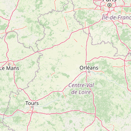
Map view of Marais de Taligny Regional Nature Reserve

Use this park location map to pinpoint Marais de Taligny Regional Nature Reserve in France, understand its exact geographic position, and read its mapped placement within the surrounding landscape more clearly.

Pigeon | © OpenStreetMap contributors

Location context for Marais de Taligny Regional Nature Reserve

Centre-Val de Loire
Park atlas

Compare surrounding valley wetlands and regional nature reserves

Other Protected Areas Near Marais de Taligny Regional Nature Reserve

Continue exploring protected landscapes and river valley reserves located near Marais de Taligny Regional Nature Reserve. Comparing adjacent wetland habitats provides deeper context on the ecological diversity of central France.
Nature reservePays de la Loire
About 23 km away#1 closest

West

Réserve naturelle régionale Champagne de Méron: Geographic and Protected Area Overview

A regional nature reserve within the Maine-et-Loire department.

Located in the heart of the Anjou countryside, Réserve naturelle régionale Champagne de Méron represents a strategic effort to safeguard biodiversity within western France. Covering 146 hectares, this protected area illustrates the intersection of modern conservation goals and historic rural landscapes, offering a clear view of how regional authorities manage and restore fragmented natural habitats.

Area
1.461 km²
Established
2023
IUCN
IV
Scope
Terrestrial
Nature reserveNouvelle-Aquitaine
About 36 km away#2 closest

Southwest

Réserve naturelle nationale du Toarcien: Protected Jurassic Stratotype and Geological Map

A vital paleontological heritage site in the Nouvelle-Aquitaine region

As the smallest national nature reserve in France, Réserve naturelle nationale du Toarcien provides a concentrated, scientifically essential view of Jurassic marine sediments. The protected quarries preserve ammonite-rich strata and complex geological unconformities, serving as the international definition for the Toarcian geological stage within the Thouet valley landscape.

Area
0.006 km²
Established
1987
IUCN
III
Relief
Lowland
Nature reserveNouvelle-Aquitaine
About 37 km away#3 closest

Southwest

Réserve naturelle régionale de la vallée du Pressoir: Protected Limestone Valley and Geoheritage

A rare natural and cultural mosaic in Nouvelle-Aquitaine

Trace the boundaries and natural features of the Réserve naturelle régionale de la vallée du Pressoir. This protected site in the Deux-Sèvres department is defined by thin calcareous soils, the historic Pommiers cascade, and fossil-rich limestone outcrops that form an unusual geoheritage landscape.

Area
0.56 km²
Established
2025
IUCN
IV
Visitors
10K annual
A soft watercolor illustration featuring a calm pond in the foreground, with reeds on the right and a distant treeline and rolling hills in the background.
Nature reservePays de la Loire
About 38 km away#4 closest

Northwest

Réserve naturelle régionale des étang et boisements de Joreau: Protected Area Atlas Profile

Wetland and woodland mosaic in the Pays de la Loire region.

This profile examines the 92-hectare Réserve naturelle régionale des étang et boisements de Joreau, a protected area in the Maine-et-Loire department. The site features a specialized composition of freshwater ponds and mature woodlands, reflecting the traditional riverine landscapes found throughout the broader Loire Valley regional geography.

Area
0.92 km²
Established
2015
IUCN
IV
A soft watercolor painting of a serene natural landscape with rolling hills, a calm body of water, and forested ridges under a pastel sky.
Nature reserveFrance
About 49 km away#5 closest

Southeast

Réserve naturelle régionale du site de Saint-Cyr: Wetland Geography and Protected Landscapes

Mapping a 39-hectare wetland refuge along the Clain river in France.

Located in the Vienne department, this regional nature reserve provides a critical link for waterbirds moving between the Loire valley and the Atlantic coast. The landscape features a mosaic of ponds, small islands, and alluvial forests that highlight the successful transition from former industrial quarry land into a biodiverse wetland ecosystem.

A soft watercolor painting of a calm pond surrounded by green grasses, shrubs, and rolling hills in the background.
Nature reserveNouvelle-Aquitaine
About 53 km away#6 closest

Southeast

Réserve naturelle nationale du Pinail: Protected Pond and Heathland Mosaic in Nouvelle-Aquitaine

Mapped geography of a unique French nature reserve

Located in the Nouvelle-Aquitaine region, Réserve naturelle nationale du Pinail preserves a rare cultural-ecological landscape. The site features an extraordinary concentration of three thousand small acidic ponds created by medieval millstone quarrying, now surrounded by protected heather and dwarf gorse heathland. This structured overview highlights the terrain, habitat connectivity, and regional importance of this internationally recognized Ramsar wetland site.

Area
1.35 km²
Established
1980
IUCN
IV
Relief
Lowland
Nature reservePays de la Loire
About 60 km away#7 closest

North

Réserve naturelle régionale des prairies et roselière des Dureaux: Loir Valley Protected Landscapes

Regional Nature Reserve in Pays de la Loire, France

Spanning the alluvial plains near Vaas, this reserve protects essential wet meadows and reedbed communities shaped by the seasonal rhythm of the Loir River. The landscape features a classic bocage character, offering a distinct example of wetland conservation within the Pays de la Loire region.

Area
0.253 km²
Established
2001
IUCN
IV
Relief
Lowland
Nature reservePays de la Loire
About 64 km away#8 closest

North

Réserve naturelle régionale du coteau et prairies des Caforts: Protected Area and Map Atlas

A diverse protected landscape in the Pays de la Loire region

Situated in the Loir valley, this regional nature reserve combines three distinct landscape types: dry limestone slopes, humid hay meadows, and 910 meters of man-made tuffeau quarry galleries. The site represents a significant pocket of biodiversity, hosting sixteen bat species and rare flora within its compact protected footprint in Sarthe.

Area
0.064 km²
Established
2009
IUCN
IV

Common questions about visiting, size, designation, and location context for Marais de Taligny Regional Nature Reserve

Marais de Taligny Regional Nature Reserve FAQs for park facts, access, geography, and protected area context

Find quick answers about Marais de Taligny Regional Nature Reserve, including protected-area facts, park geography, trail and visitor context, and how the park fits into its surrounding country and regional landscape.
MoriAtlas Explorer

Continue Your Protected Areas Search Across the Global Atlas

Deepen your exploration by continuing the structured search for national parks and protected areas worldwide. Utilize the comprehensive filtering capabilities to compare different conservation landscapes and refine your understanding of global park geography. Discover more about the distribution and characteristics of protected natural areas.

Global natural geography