

Mori Atlas logo
Nature reserveRéserve spéciale d'Andranomena

A vital protected nature reserve characterized by seasonal lakes and towering endemic baobab forests.

Réserve spéciale d'Andranomena: Mapping the Biodiversity and Dry Forest Landscapes of Western Madagascar

Located in the Menabe region of western Madagascar, Réserve spéciale d'Andranomena spans 6,420 hectares of dense, dry deciduous canopy and ephemeral water bodies. This protected area supports a dense concentration of endemic flora and fauna, including rare lemur species and unique tortoise habitats. The landscape is defined by its shifting mosaics of forest margins and seasonal lakes, offering a significant window into the specialized ecology of the region.

dry deciduous forestbaobabslemursendemic speciesseasonal lakeswestern Madagascar

Réserve spéciale d'Andranomena

Nature reserve

Park overview

Structured park overview, official facts, and landscape profile for Andranomena Special Reserve

Andranomena Special Reserve park facts, protected area profile, and essential visitor context

Review the core facts for Andranomena Special Reserve, including designation, size, terrain, visitor scale, habitats, and operating context in one park-focused overview.

About Andranomena Special Reserve

Andranomena Special Reserve occupies a meaningful place within Madagascar's network of protected areas. It lies in the western part of the country, in an area where the dry deciduous forests that once stretched across much of the Menabe region still survive in fragments. The reserve was established in 1958, more than six decades ago, and continues to function as a key refuge for the ecological character that defines this coastal-interior transition zone of western Madagascar.

The protected area sits in a tropical climate with two clearly contrasting seasons. From November through March the area experiences its hot and rainy period, with January and February being the wettest months; from April through October it enters a dry season during which many of the smaller watercourses lose their flow. Annual rainfall averages between roughly 600 and 1,200 millimeters, and the mean annual temperature is around 25 degrees Celsius, with January the hottest month and July the coolest. These conditions strongly shape the rhythm of the forest and the temporary lakes scattered across the reserve.

Within the reserve, a continuous strip of dense dry forest runs roughly north to south, broken up by a series of seasonal lakes and open clearings. Baobabs dominate the skyline, both as solitary specimens and as memorable paired or fused forms, and the understory supports a wide range of woody plants. The combination of dry forest, seasonal wetlands, riparian vegetation around the lakes, and open clearings creates a layered habitat mosaic that sustains a notable vertebrate community as well as 113 inventoried woody plant species. The reserve's access throughout the year, combined with its proximity to Morondava, places it at the intersection of conservation, science, and regional tourism in western Madagascar.

Quick facts and research context for Andranomena Special Reserve

Andranomena Special Reserve is a Malagasy protected area classified under IUCN Category IV and administered through the country's system of special reserves. It was established on 29 October 1958 by decree and occupies approximately 64 square kilometers of dry forest in the Menabe region, northeast of Morondava. The reserve is recorded in the World Database on Protected Areas under WDPA ID 5040. Its flora and fauna are about 80 percent endemic, including multiple species of baobab, seven species of lemur, and the locally endemic flat-tailed tortoise. Local communities within and around the reserve's perimeter are predominantly Sakalava and Korao.

Protection and recognition

Terrestrial conservation framework and documented protection metrics

Réserve spéciale d'Andranomena Protection Status and Designated Area Record

Réserve spéciale d'Andranomena maintains a documented terrestrial protection scope within official conservation databases. Detailed records outline the foundational management parameters and administrative designation history associated with the protected landscape.

Protection details

Protection scope
Terrestrial
WDPA ID
5040
Park context

Deeper park guide and search-rich context for Andranomena Special Reserve

Andranomena Special Reserve history, landscape, wildlife, and travel context

Explore Andranomena Special Reserve through its history, landscape character, ecosystems, wildlife, conservation priorities, cultural context, and seasonal travel timing in a structured park guide built for atlas discovery and search intent.

Why Andranomena Special Reserve stands out

Andranomena is best known for its towering baobabs, especially the iconic Adansonia grandidieri and its rarer relatives, which together form nearly the full set of Bombacaceae species in the area. Botanists have inventoried 113 woody plant species in the reserve's dry dense forest, an unusually rich count for the western Menabe ecosystem. The reserve is equally celebrated for its biodiversity. It shelters seven lemur species, including the locally endemic Madame Berthe's mouse lemur (Microcebus berthae), the rare flat-tailed tortoise (Pyxis planicauda), and the endangered giant jumping rat (Hypogeomys antimena). The combination of seasonal lakes, dry deciduous canopy, and high endemism gives Andranomena a strong identity, distinct from the more touristic baobab landscapes to the south and from Kirindy Mitea further north.

Andranomena Special Reserve history and protected-area timeline

Andranomena Special Reserve was created by decree on 28 October 1958, making it one of the older entries in Madagascar's formal network of protected areas. Its establishment reflected an early recognition of the ecological value of the western Menabe dry forests, which were already understood as harboring a high proportion of endemic species.

The reserve's identity as a site of scientific interest stems from the unusually high level of endemism recorded in its flora and fauna, something later inventories have continued to confirm. Over time, Andranomena has become part of the countrywide system of aires protégées and is administered under IUCN Category IV, a classification reflecting its role as a managed habitat and species conservation area rather than a strict wilderness reserve.

While the surrounding lands have long been inhabited by Sakalava and Korao communities, the reserve itself has functioned as a refuge for native wildlife and native plant communities even as forests elsewhere in the region have come under pressure. Its continuity as a protected area across more than six decades has allowed long-term observations of species such as the flat-tailed tortoise, lemurs, and the rare Hazomalania voyroni tree, contributing to the broader scientific understanding of Madagascar's western dry-forest ecosystems.

Andranomena Special Reserve landscape and geographic character

The landscape of Andranomena is shaped by a continuous block of dense dry forest running from north to south, interrupted by clearings, seasonal lakes, and patches of more open vegetation. Within the reserve, travelers move beneath a high canopy dominated by monumental baobabs, which give the area a striking visual signature. The most familiar form is the massive, column-trunked Adansonia grandidieri, often standing in scattered clearings, but the reserve also harbors Adansonia rubrostipa and the locally significant Adansonia za.

Several of the baobabs have grown into unusual shapes; some grow closely paired and appear fused, producing the characteristic so-called 'baobabs amoureux' (lover baobabs) and other distinctive forms that have become emblematic of the region. Reading the reserve on foot, one moves through cathedral-like stands of canopy trees, around grassy lake margins, and across more open dune-influenced terrain near the coast.

The reserve's network of temporary lakes, including locally named features such as Angongo, Vivy, Vano, and Kapi-drano, contributes further character to the landscape. These lakes fill during the rainy season and contract or dry out during the long dry months, creating shifting mosaics of open water, marshy fringes, and saturated forest margins. This seasonal hydrology shapes the experience of the reserve, influencing not only what one sees but also which bird and mammal species are most visible during a given time of year.

Andranomena Special Reserve ecosystems, habitats, and plant life

Andranomena's ecological identity is rooted in the dry deciduous forest of western Madagascar, an ecosystem type that has been reduced to fragments across much of its former range. The reserve preserves a relatively continuous block of this habitat, with 113 woody plant species inventoried to date. The flora is dominated by baobabs of the Bombacaceae family, with three species (Adansonia grandidieri, Adansonia rubrostipa, and Adansonia za) accounting for an overwhelmingly large share of the family's representation in the area.

Beyond the baobabs, the forest hosts a rich mix of dry-forest trees and shrubs suited to seasonal drought, including the rare and threatened Hazomalania voyroni. The combination of closed-canopy dry forest, periodically inundated lake margins, and very open clearings supports a layered vegetation structure, with different microhabitats occurring across short distances.

This habitat diversity in turn underpins the reserve's unusually high level of endemism, estimated at around 80 percent for its combined flora and fauna. The interplay between the dry-forest matrix and the seasonal wetlands, together with the area's long history of isolation from mainland Africa, gives Andranomena a distinct ecological character within Madagascar's broader protected-area network, despite its relatively modest size.

Andranomena Special Reserve wildlife and species highlights

Wildlife is one of the reserve's main draws. Inventories have recorded 11 reptile species, 48 bird species, 7 lemur species, and 4 rodent species. Together with numerous plant species, these groups support the reserve's reputation as a living laboratory of western Malagasy biodiversity.

Among reptiles, the flat-tailed tortoise Pyxis planicauda, known locally as Kapi-dolo, is a notable endemic of the local area. The reserve also hosts two species of typically Malagasy chameleons and other reptiles adapted to the dry-forest mosaic.

Lemurs are a particular highlight. Two diurnal species, Verreaux's sifaka (Propithecus verreauxi verreauxi) and the reddish-brown lemur (Eulemur fulvus rufus, locally Gidro), are relatively easy to observe. Five nocturnal species round out the community: Madame Berthe's mouse lemur (Microcebus berthae), Berthe's mouse lemur being a local endemic and one of the smallest primates in the world; the red-tailed sportive lemur (Lepilemur ruficaudatus); the gray mouse lemur (Microcebus murinus); the fork-marked lemur (Phaner furcifer); and Coquerel's dwarf lemur (Mirza coquereli). Rodents include the endangered giant jumping rat (Hypogeomys antimena, locally Vositse), a Malagasy endemic restricted to a small portion of the Menabe region.

Andranomena Special Reserve conservation status and protection priorities

Andranomena's conservation significance runs deeper than its formal protected status. Although only about 64 square kilometers in extent, the reserve preserves a relatively intact example of the dry deciduous forest ecosystem that once covered far larger portions of western Madagascar, including the drier, baobab-rich formations that have been heavily degraded elsewhere.

The reserve's flora and fauna are estimated at roughly 80 percent endemic, including both Malagasy endemics and narrowly local endemics such as Microcebus berthae, Pyxis planicauda, and parts of the rodent community represented by Hypogeomys antimena. This level of endemism places the reserve in the same general category of conservation importance as the larger Kirindy Mitea National Park to its north and the protected forests surrounding the Avenue of the Baobabs to its south.

Classified under IUCN Category IV, the reserve is managed to maintain habitat and species populations while allowing some regulated use. The presence of rare tree species such as Hazomalania voyroni underscores the importance of continuing forest cover protection. Organizations supporting Madagascar's protected areas, including the Fondation pour les Aires Protégées et la Biodiversité de Madagascar, work in conjunction with national authorities to sustain funding and management for the country's system of aires protégées, of which Andranomena is a part.

Andranomena Special Reserve cultural meaning and human context

The reserve sits within a landscape shaped by longstanding human presence. The communities living within the vicinity of the reserve are predominantly composed of two ethnic groups: the Sakalava, who are the dominant cultural group across much of western Madagascar, and the Korao, a smaller community also established in the Menabe region.

These communities have long coexisted with, and drawn livelihoods from, the dry-forest environment around Andranomena. Their presence has influenced land use patterns at the edges of the reserve and contributes to the broader Menabe regional identity, which combines coastal livelihoods around Morondava, traditional Sakalava political and cultural heritage, and intimate familiarity with the local baobab-and-forest landscape.

Although the core of the reserve is protected, the surrounding human context remains an integral part of the area's character. Conservation management in the region increasingly recognizes the importance of these communities, and the reserve's long-term viability depends on relationships between local populations, national authorities, and supporting conservation organizations.

Top sights and standout views in Andranomena Special Reserve

Andranomena offers a compelling combination of accessible dry-forest exploration, dramatic baobab scenery, and a high concentration of endemic wildlife. The reserve's continuous stretch of dense dry forest, scattered with unusual baobab forms and set against a backdrop of seasonal lakes, gives the area an unmistakable Menabe character. Seven lemur species, including Madame Berthe's mouse lemur, and the locally endemic flat-tailed tortoise distinguish it from many other western Madagascar reserves.

Best time to visit Andranomena Special Reserve

The reserve is accessible year-round, but the character of a visit shifts significantly with the seasons. The hot, rainy season from November to March brings the seasonal lakes to their fullest extent, supporting abundant waterbird activity and lush undergrowth, though humid and hot conditions can make exploration more demanding. January and February typically receive the heaviest rainfall.

The dry season from April to October, with cooler temperatures in July and clearer skies, tends to draw visitors who want to appreciate the baobabs at their most sculptural and to walk through the open, more accessible forest. Many watercourses recede during this period, so wildlife observation shifts more toward dry-forest species such as lemurs, reptiles, and ground-dwelling rodents. Either season offers a different but rewarding experience of the reserve's landscapes and fauna.
Monthly climate preview

Long-term temperature and precipitation averages across the representative coordinate

Réserve spéciale d'Andranomena Climate Normals and Monthly Weather Patterns

Historical measurements from 1991 to 2020 outline a consistent annual rhythm of average temperatures and monthly precipitation levels at Réserve spéciale d'Andranomena. Reviewing the complete twelve-month climatology profile provides deeper insight into measured meteorological patterns across the protected landscape.
Annual mean26 °C
23 °C29 °C
Jan28°
Feb28°
Mar28°
Apr27°
May25°
Jun24°
Jul23°
Aug24°
Sep26°
Oct27°
Nov28°
Dec29°
Warmest month
December

28.6 °C

Coolest month
July

23.3 °C

Wettest month
January

10.5 mm/day

Driest month
August

0.2 mm/day

Park location guide

Geography guide, regional context, and park location map for Andranomena Special Reserve

Andranomena Special Reserve park geography, regions, and map view in Madagascar

Understand where Andranomena Special Reserve sits in Madagascar through a broader geographic reading of the surrounding landscape, nearby location context, and its mapped position within the national park landscape.

How Andranomena Special Reserve fits into Madagascar

Madagascar is an island nation in the Indian Ocean, positioned off the southeastern coast of Africa. As the world's fourth-largest island and second-largest island country, it stands out for its exceptional biodiversity, over 90% of its wildlife is endemic, making it one of 17 megadiverse countries. The population is approximately 32 million, with Antananarivo as both the capital and largest city.

Wider geography shaping Andranomena Special Reserve in Madagascar

Madagascar lies in the Indian Ocean off the southeastern coast of Africa, separated from the mainland by the Mozambique Channel. The island is situated approximately 400 km from the African continent. As the world's fourth-largest island, it also includes numerous smaller peripheral islands.

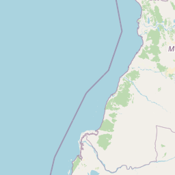
Map view of Andranomena Special Reserve

Use this park location map to pinpoint Andranomena Special Reserve in Madagascar, understand its exact geographic position, and read its mapped placement within the surrounding landscape more clearly.

Pigeon | © OpenStreetMap contributors
Park atlas

Compare adjacent dry deciduous forests and regional protected areas across western Madagascar

Exploring Parks Near Réserve spéciale d'Andranomena and Surrounding Protected Landscapes

Browsing other protected areas near Réserve spéciale d'Andranomena reveals connected dry forest habitats, seasonal lakes, and rich endemic biodiversity across the Menabe region. Comparing adjacent nature reserves provides deeper geographic context for understanding western Madagascar conservation landscapes and regional wilderness patterns.
Nature reserveToliara Province
About 81 km away#1 closest

Southwest

Kirindy Forest Nature Reserve: Protected Dry Deciduous Forest in Western Madagascar

Geography, protected boundaries, and unique dry forest ecosystems

Kirindy Forest offers a detailed look into the ecology of western Madagascar. As a protected nature reserve, it shelters three species of baobab trees and diverse primate populations. Its terrain ranges from flat to gently undulating, creating a distinct visual rhythm through alternating dry and rainy seasons within the Menabe region.

Area
125 km²
Relief
Lowland
Climate
Tropical
Access
Moderate access
National parkMadagascar
About 81 km away#2 closest

Southwest

Kirindy Mitea National Park: Madagascar National Park with Distinct Protected Landscape Identity

Explore the mapped geographic context of Kirindy Mitea National Park.

Kirindy Mitea National Park serves as a notable protected area, holding national park status within Madagascar's distinctive island geography. This entry focuses on understanding the park's unique protected landscape and its charted boundaries, offering essential context for atlas-driven exploration. Discover the geographic elements that define Kirindy Mitea National Park and its place within the broader conservation map of the region.

Area
1,563.5 km²
Established
1997
IUCN
IV
Relief
Mixed relief
National parkMelaky
About 116 km away#3 closest

North

Tsingy de Bemaraha National Park: A Protected Landscape within Melaky, Madagascar

Explore mapped boundaries and regional geography for atlas discovery.

Tsingy de Bemaraha National Park is a designated national park offering profound opportunities for geographic discovery. As a key protected area in the Melaky region, its mapped boundaries and natural landscape characteristics are vital for understanding Madagascar's conservation geography. This resource facilitates detailed atlas exploration, providing structured insights into the park's terrain and its position within the broader regional context, enabling a focused study of its protected land identity.

Area
723.4 km²
Established
1997
IUCN
II
Visitors
10.1K annual
Marine protected areaMelaky
About 167 km away#4 closest

North

Barren Isles Marine Protected Area: Geographic Overview and Island Chain Mapping

Exploration of the nine islands in the Mozambique Channel.

The Barren Isles comprise a distinct chain of nine islands and sand banks stretching across the Mozambique Channel in Madagascar. This marine protected area offers a look into a complex coastal system that balances sensitive wetland habitats with seasonal maritime migration. Gain geographic perspective on this isolated archipelago located within the Melaky region, where shifting marine environments create a unique natural landscape.

Water
Water-dominated
Nature reserveMelaky
About 193 km away#5 closest

North

Tsingy de Bemaraha Strict Nature Reserve: Karst Pinnacles and Protected Landscapes

Exploration of Madagascar karst geography and Melaky forest zones

Tsingy de Bemaraha Strict Nature Reserve is recognized for its unique labyrinth of stone needles and extensive canyon systems carved into the limestone plateau. The protected area preserves a rich variety of habitats, including dry tropical forests and riverine corridors that support a high concentration of endemic species. Delve into the mapped boundaries and topographical complexity of this iconic Madagascar landscape to understand its vital role in regional conservation.

Area
1,577.1 km²
Established
1927
IUCN
Ia
Relief
Highland
National parkIhorombe Region
About 235 km away#6 closest

South

Isalo National Park: Explore Madagascar's Sandstone Canyons and Protected Landscape Geography

Discover unique geology, tapia woodlands, and regional park context.

Isalo National Park is a prominent protected area in Madagascar's Ihorombe Region, celebrated for its spectacular sandstone landscape. This national park features deep canyons, eroded rock domes, and striking runiform mountains, formed from ancient sedimentary deposits. The park preserves significant tapia woodlands and remarkable plant endemism, offering a rich context for understanding protected land distribution and Madagascar's unique geography. Its mapped terrain provides a visual atlas of natural wonders.

Area
815.4 km²
Established
1962
IUCN
II
Visitors
32.7K annual
Marine protected areaMadagascar
About 249 km away#7 closest

Southwest

Velondriake Marine Protected Area: Coastal Geography and Conservation Landscape in Madagascar

A large-scale community marine reserve in southwestern Madagascar.

Velondriake protects 64,000 hectares of marine and terrestrial environment, spanning coral reefs, extensive mangroves, and inland baobab-rich spiny forests. As a focal point for regional marine management, the area showcases the intersection of coastal ecology and community governance in the western Indian Ocean. Explore the geographic boundaries and habitat features that define this significant marine protected territory along the coast of Madagascar.

Area
640 km²
Established
2006
Relief
Lowland
Climate
Tropical
Natural monumentAtsimo-Andrefana
About 288 km away#8 closest

South

Analavelona Natural Monument: An Isolated Montane Forest Refuge in Southwestern Madagascar

Mapping a sacred and biodiverse massif in the Atsimo-Andrefana region

Analavelona Natural Monument represents a striking geographic contrast, standing as an elevated montane forest massif surrounded by arid plains. This protected landscape contains a complex ecological mosaic, ranging from humid evergreen forests to rocky sclerophyllous slopes. Recognized for its sacred status and high level of narrow-range endemism, the massif serves as an essential ecological island within the broader topography of southwestern Madagascar.

Area
44.87 km²
Established
2015
Relief
Mountain
Climate
Tropical

Common questions about visiting, size, designation, and location context for Andranomena Special Reserve

Andranomena Special Reserve FAQs for park facts, access, geography, and protected area context

Find quick answers about Andranomena Special Reserve, including protected-area facts, park geography, trail and visitor context, and how the park fits into its surrounding country and regional landscape.
MoriAtlas Explorer

Continue Your Protected Areas Search Across the Global Atlas

Deepen your exploration by continuing the structured search for national parks and protected areas worldwide. Utilize the comprehensive filtering capabilities to compare different conservation landscapes and refine your understanding of global park geography. Discover more about the distribution and characteristics of protected natural areas.

Global natural geography